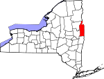
Washington County, New York Basics:


Washington County New York - Government Site

Population: 63,331
Area: 831 square miles
County seat: Fort Edward
Area code(s) in use: 518
Time zone: EST
High school graduate or higher: 86.7%
Bachelor's degree or higher: 17.0%
Median household income: $50,864
Persons in poverty: 12.7%
Home ownership rate: 74.6%
Mean travel time to work: 26.4 minutes


Adjacent counties:
Addison (VT)  Bennington (VT)  Essex  Rensselaer  Rutland (VT)  Saratoga  Warren  
Find in New York

Map of the Washington County area


Our detail map of Washington County shows the Washington County, New York boundary lines and other interesting items.

Places in Washington County, New York

  Airports     show all on map

Archdale Meadows Airport, Argyle Airport, Chapin Field Airport, Granville Airport, Harris Airport, Meerwarth Airport, Mountain View Airport, Tracy Field Airport

  Bays     show all on map

Barret Bay, Cooks Bay, Echo Bay, Mill Bay, South Bay, Weeds Bay

  Bends     show all on map

Chilson Bend, The Elbow

  Bridges     show all on map

Baldwin Corners Road Bridge, Batten - Dugan Road Bridge, Batten Kill Bridge, Batten Kill Bridge, Buskirks Covered Bridge, Champlain Canal Bridge, Clay Hill Road Bridge, Deweys Bridge Road Bridge, Eagleville Covered Bridge, Fort Miller Road Bridge, New Swamp Road Bridge, North River Road Bridge, Rexleigh Bridge, Shushan Covered Bridge, South Bay Causeway

  Buildings     show all on map

All Saints Hall (historical), Argyle Emergency Squad, Argyle Fire and Rescue, Argyle Free Library, Bancroft Public Library, Cambridge Public Library, Cambridge Valley Rescue Squad, Capitol Theatre (historical), Carey Camp Post Light, Chilson Bend Lighthouse, Easton Greenwich Rescue Squad, Easton Library, Easton Volunteer Fire Company, Fort Ann Rescue Squad, Fort Ann Volunteer Fire Company, Fort Edward Free Library, Fort Edward Rescue Squad, Fort Edward Village Fire Department, Fort Hudson Nursing Home, Granville Fire Station Number 1 (historical), Granville Hook and Ladder Company, Granville Municipal Building, Granville Rescue Squad, Great Meadow State Correctional Facility, Greenwich Fire Department, Greenwich Free Library, Hampton Volunteer Fire Company, Hartford Volunteer Fire Company, Henry Hose Company 1, Holbrook's Adult Home, Hudson Falls Free Library, Hudson Falls Hose Company Number 2, Hudson Falls Village Offices, Hudson Falls Volunteer Fire Department, Indian River Rehabilitation and Health Care Center, Isaac C Griswold Library, J A Barkley Hose Company, Kingsbury Volunteer Hose Company, Middle Falls Fire Department, New Arlington Hotel (historical), Niagara-Mohawk Power Corporation Middle Falls Hydro Station, North Granville Fire Company, Old Fort Museum, Pastime Theatre, Pember Library And Museum, Pilot Knob Volunteer Fire Company, Pleasant Valley Adult Home, Putnam Volunteer Fire Company, Salem Rescue Squad, Skenesborough Emergency Squad, The Orchard, Town of Whitehall Offices, Washington County Court House (historical), Washington County Home For Aged Women (historical), Washington County Jail, Washington State Correctional Facility, West Fort Ann Volunteer Fire Company, Whitehall Free Library, Whitehall Village Office, Whitehall Volunteer Fire Company

  Canals     show all on map

Champlain Canal, Old Champlain Canal

  Capes     show all on map

Flat Rock, Gourlie Point, Pulpit Point, Sixmile Point

  Cemeteries     show all on map

Adamsville Cemetery, Argyle Cemetery, Baker Cemetery, Binninger Cemetery, Boardman Cemetery, Braymer Cemetery, Brown Cemetery, Brownell Cemetery, Burch Cemetery, Camden Cemetery, Cleveland Cemetery, Comstock Cemetery, Congregational Cemetery, Cossayuna Cemetery, East Hebron Cemetery, Elmwood Cemetery, Evergreen Cemetery, Fort Ann Village Cemetery, Gillette Cemetery, Glasier Cemetery, Greenmont Cemetery, Greenwich Protestant Cemetery, Griswold Cemetery, Hampton Flats Cemetery, Holy Cross Cemetery, Hooker Cemetery, Meadow Knoll Cemetery, Mettawee Valley Cemetery, Miller Cemetery, Moorehouse Cemetery, Moss Street Cemetery, Mount Carmel Cemetery, Neddo Cemetery, North Argyle Cemetery, North Granville Cemetery, Old North Argyle Cemetery, Orcutt Cemetery, Our Lady of Angels Cemetery, Parish Cemetery, Prospect Hill Cemetery, Putnam Cemetery, Quaker Cemetery, Quaker Cemetery, Revolutionary War Cemetery, Reynolds Cemetery, Rodd-Elbow Cemetery, Rosewood Cemetery, Saint Josephs Cemetery, Saint Pauls Cemetery, Sciota Cemetery, Sheldon Cemetery, Smith Cemetery, South Argyle Cemetery, Tanner Cemetery, Taylor Hill Cemetery, Union Cemetery, Warren Cemetery, Welch Hollow Cemetery, Williams Street Cemetery, Woodland Cemetery

  Churches     show all on map

Adamsville Baptist Church, Advent Christian Church, All Saints Roman Catholic Church (historical), Argyle United Methodist Church, Argyle United Presbyterian Church, Bottskill Baptist Church, Calvary Baptist Church, Cambridge United Presbyterian Church, Centenary United Methodist Church, Church of Our Lady of the Angels, Coila Church, Cornerstone Full Gospel Church, Durkeetown Baptist Church, Embury Methodist Church, First Baptist Church, First Baptist Church, First Baptist Church, First Presbyterian Church, First Presbyterian Church, First Presbyterian Church, Friends Church, Fruitful Vine Christian Church, Gospel Lighthouse Church, Grace Baptist Church, Granville Baptist Church, Greater Glens Falls Bible Baptist Church, Hartford Baptist Church, Hebron Church, Holy Cross Catholic Church, Hudson Falls United Methodist Church, Jerusalem Welsh Congregational Church, Kingdom Hall of Jehovahs Witnesses, Kingdom Hall of Jehovahs Witnesses, Kingsbury Wesleyan Church, Log Chapel, New Life Baptist Church, North Argyle Community Church, Open Bible Baptist Church, Our Lady of Hope Church, Peniel Presbyterian Church, Putnam Church, River Church, Saint Ann's Catholic Church, Saint James Episcopal Church, Saint Joseph's Roman Catholic Church, Saint Joseph's Roman Catholic Church, Saint Lukes Church, Saint Mary's Church, Saint Mary's Roman Catholic Church, Saint Marys Roman Catholic Church, Saint Patrick's Church, Saint Paul's Episcopal Church, Saint Paul's Roman Catholic Church, Saint Peter And Saint Paul Greek Catholic Church, Salem Methodist Church, Sanfords Ridge United Methodist Church, Seventh Day Adventist Church, South Granville Congregational Church, Trinity Episcopal Church, Trinity Episcopal Church, Truthville Baptist Church, United Presbyterian Church, United Protestant Church, Village Baptist Church, West Fort Ann Methodist Church, West Hebron Presbyterian Church, Whitehall United Methodist Church, Whiteside Church, William Miller Chapel, Zion Episcopal Church

  Cliffs     show all on map

Anthonys Nose, Rogers Slide

  Dams     show all on map

Carver Falls Dam, Lock Number 6, Lock Number 7, Lock Number 8, Lock Twelve

  Falls     show all on map

Bakers Falls, Buttermilk Falls, Kane Falls

  Gaps     show all on map

Big Notch, The Notch

  Guts     show all on map

East Bay, Wood Creek, Wood Creek

  Harbors     show all on map

Fort Edward Yacht Basin

  Hospitals     show all on map

Emma Lang Stevens Hospital (historical), Mary Mc Clellan Hospital (historical)

  Islands     show all on map

Big Island, Galusha Island, Juniper Island, Maple Bend Island, Rogers Island, Turtle Rocks

  Lakes     show all on map

Bacon Pond, Barkley Pond, Beaver Pond, Black Mountain Ponds, Browns Pond, Bumps Pond, Carter Pond, Cat Den Bay, Clark Pond, Clear Pond, Copeland Pond, Cossayuna Lake, Crossett Pond, Crystal Lake, Dead Lake, Dolph Pond, Dunbar Pond, Fishbrook Pond, Gillespie Pond, Green Pond, Greenland Pond, Halls Pond, Hedges Lake, Hills Pond, Inman Pond, Lake Lauderdale, Lake Nebo, Lake Pond, Lapland Pond, Lily Pond, Martins Pond, McDougall Lake, Melvin Pond, Millman Pond, Mud Pond, Mud Pond, Mud Pond, Pine Lake, Rathbun Pond, Ryan Pond, Sawmill Pond, Schoolhouse Lake, Scott Lake, Sheltered Lakes, Sly Pond, Smith Pond, Spectacle Pond, Spectacle Ponds, Spruce Pond, Summit Lake, The Old Fly, The Three Ponds, Thurber Pond, Thurber Pond, Vanderburg Pond

  Locales     show all on map

B and C Farms, Batten Kill Country Club, Battenkill Railroad Station, Battenkill Riversports and Campground, Beech Hill Farm, Birch Hill Farm, Borden's Orchard, Brookefield Farm, Butternut Ridge Farms, Camp Adirondack, Camp Endion, Camp Little Notch, Camp Mohican, Camp Wakpominee, Chamberlin Mills, Chambers Valley Farms, Chubbs Dock, Chubbs Dock Light, Dix Drive-In (historical), Double Bar D Ranch, Dunham Basin, Edgewood Farm, Elihu Farm, Elm Spring Farm, Ewetopia Farm, Fairview Orchard, Fannicap Gardens, Flying Pigs Farm, Fort Edward Landfill, Goodmanor Farms, Goose Island Farm, Grand Union Plaza Shopping Center, Green Hill Organic Orchard, Green Thumb Nursery, Hampton Flats, Happenchance Farm, Happy Hill Farm, Head of Lake Champlain, Hemlock Grove Farm, Hicks Orchard, Highland Maple Farm, Holstein Heaven Farm, Hudson Falls Sewage Disposal Plant, Hulett's Golf Course, Kingsbury Landfill, Kingswood Golf Club, Lake Lauderdale Campground, Lock Twelve Marina, M And A Farm, MacClan Farms, Manx Station Farm, Mapleland Farm, McWhorters Orchard, Mettawee Valley Farm, Milton Farms, Moses Creek Farm, New England Farms, Niagara-Mohawk Power Corporation Hudson Falls Sub-Station, Ottenburgs Ramp, Perrys Orchard, Pine Meadow Farm, Pleasant Valley Farm, Pole Valley Players Club, Post Corners, R And R Farms, Rainbows End Farm, River Edge Farm, Shelving Rock, Silver Eagles Farm, Skene Valley Country Club, Skiff Farm, Smiths Basin, Snody Dock, Stannard Farm, Star Ridge Farm, Sunny Crest Tree Farm, Sunrise Mountain Buffalo Ranch, The Hook, Valley View Golf Course, Walker Farms, Warren-Washington County Industrial Park, Washington County Fairgrounds, Washington Square, Wedgewood Golf Club, White Feather Farm, Whitehall Drive-In (historical), Whitehall Marina, Windy Hills Golf Course, Windy River Farm, Yorkmont Farm

  Military     show all on map

Whitehall Armory

  Mines     show all on map

Deweys Bridge Quarry, Elvell Quarry, Fort Ann Quarry, Hartford Quarry, Hooper Mine, Penrhyn Hill Vein Slate Quarry, Phillips Quarry, Sheldon Slate Quarry, South Bay Quarry, Western Slate Quarry

  Parks     show all on map

Cambridge Historic District, Carters Pond State Wildlife Management Area, Derby Park, Hudson Falls Historic District, Lake Lauderdale County Park, Main Street Historic District, Richards Memorial Park, Riverside Park, Rogers Rock Park, Salem Historic District, Underwood Park, Village of Greenwich Historic District

  Pillars     show all on map

Death Rock, Devils Pulpit

  Populated Places     show all on map

Adamsville, Anaquassacook, Archdale, Argyle, Ash Grove, Bald Mountain, Baldwin Corner, Barkers Grove, Battenville, Belcher, Cambridge, Center Cambridge, Center Falls, Center White Creek, Chubbs Dock, Clarks Mills, Clemons, Coila, Comstock, Cossayuna, Country Acres, Crandall Corners, Dix Mobile Home Park, Dresden, Dresden Center, Durkeetown, Eagleville, East Greenwich, East Hartford, East Hebron, East Whitehall, Easton, Fitch Point, Fly Summit, Fort Ann, Fort Edward, Fort Miller, Glenburnie, Goose Island, Granville, Grays Corner, Greenwich, Greenwich Junction, Hampton, Hartford, Hillsdale, Hogtown, Hudson Falls, Huletts Landing, Iron Furnace, King Edward Knolls, Kingsbury, Lee, Lick Springs, Low Hampton, Middle Falls, Middle Granville, Mount Hope, North Argyle, North Cambridge, North Easton, North Granville, North Greenwich, North Hebron, Oak Hill, Pattens Mills, Porter, Pumpkin Hook, Putnam, Putnam Station, Raceville, Ravenwood Estates, Rexleigh, Salem, Shushan, Slateville, Slyboro, South Argyle, South Bay, South Cambridge, South Easton, South Granville, South Hartford, Spraguetown, The Plains, Thomson, Tiplady, Tripoli, Truthville, Vaughns Corners, West Cambridge, West Fort Ann, West Granville, West Hebron, White Creek, Whitehall, Whitehall Mobile Home Park, Wright

  Post Offices     show all on map

Argyle Post Office, Clemons Post Office, Comstock Post Office, Comstock Post Office, Cossayuna Post Office, Dresden Station Post Office, Fort Ann Post Office, Fort Edward Post Office, Granville Post Office, Greenwich Post Office, Hampton Post Office, Hudson Falls Post Office, Huletts Landing Post Office, North Granville Post Office, Putnam Station Post Office, Whitehall Post Office

  Reservoirs     show all on map

Hadlock Pond, Whitehall Reservoir

  Ridges     show all on map

Camden Ridge, Chestnut Ridge, Goose Egg Ridge, Hogback Ridge, Redstone Ridge, Snake Ridge, State Line Ridge

  Schools     show all on map

Adirondack Community College, Argyle Central School, Beech Hill School, Braymer School (historical), Burgoyne Avenue Elementary School, Cambridge Central School, Carlton School, Cary School (historical), Central High School (historical), F E Powers Public School (historical), Fort Ann Central School, Fort Edward Elementary School, Fort Edward High School, Granville Elementary School, Granville High School, Greenwich Central School, Harlow School, Hartford Central School, Hudson Falls Intermediate School, Hudson Falls Middle School, Hudson Falls Primary School, Hudson Falls Senior High School, John Street School (historical), Main Street School, Margaret J O'Donnell Public School, Margaret Murphy Kindergarten Center, Mary J Tanner Elementary School, New Boston School, North Bend School, Pike Brook School, Poultney School, Putnam Central School, Quaker Street School (historical), Rathbunville School, Rock Hill School, Saint Josephs School, Saint Mary's Parochial School, Saint Paul's Parochial School, Salem Central School, Salem School (historical), School Number 1 (historical), School Number 1 (historical), School Number 1 (historical), School Number 11 (historical), School Number 11 (historical), School Number 13 (historical), School Number 13 (historical), School Number 13 (historical), School Number 14 (historical), School Number 2 (historical), School Number 2 (historical), School Number 2 (historical), School Number 2 (historical), School Number 3 (historical), School Number 4 (historical), School Number 4 (historical), School Number 4 (historical), School Number 4 (historical), School Number 5 (historical), School Number 5 (historical), School Number 5 (historical), School Number 6 (historical), School Number 6 (historical), School Number 6 (historical), School Number 6 (historical), School Number 7 (historical), School Number 8 (historical), School Number 9 (historical), Schuylerville Prep School, Sciota School, South Bay School, Truthville Christian Academy, Union School Number 2 (historical), Whitehall Elementary School, Whitehall Junior-Senior High School, Williams Street School (historical)

  Springs     show all on map

Cold Spring

  Streams     show all on map

Batten Kill, Beaver Brook, Big Creek, Bishop Brook, Black Creek, Black House Creek, Blind Buck Stream, Bond Creek, Buttermilk Falls Brook, Cambridge Creek, Camden Creek, Castle Creek, Center White Creek, Charter Brook, Chunks Brook, Dead Creek, Dead Creek, Dry Creek, Ensign Brook, Flately Brook, Flaxmill Brook, Fly Creek, Fryer Brook, Gavettes Brook, Gillis Brook, Greenland Brook, Halfway Creek, Hartshorn Brook, Indian River, Juniper Swamp Brook, Livingston Brook, McAuley Brook, Mettawee River, Mill Brook, Moses Kill, Mount Hope Brook, Mud Brook, Owl Kill, Pencil Brook, Pike Brook, Pine Lake Brook, Poultney River, Pumpkin Hook Creek, Schuyler Brook, Slocum Creek, South Bay Creek, Spectacle Brook, Steele Brook, Sucker Brook, Trout Brook, Van Antwerp Creek, West Beaver Brook, West Branch Black Creek, West Camden Creek, Whipple Brook, White Creek, White Creek, Whiteside Creek, Whittaker Brook, Winchell Creek, Wood Creek

  Summits     show all on map

Bald Mountain, Bald Mountain, Barber Hills, Barkley Mountain, Bartholomew Hill, Battle Hill, Beadle Hill, Becker Hill, Berry Hill, Black Lead Hill, Black Mountain, Black Mountain, Brimstone Hill, Browns Mountain, Buck Mountain, Bull Hill, Cement Mountain, Christian Hill, Dick Hill, Dugway Mountain, Elephant Mountain, Erebus Mountain, Fish Hill, Gavettes Mountain, Grimes Hill, Hampton Hill, Hatch Hill, Hebron Mountain, Herrington Hill, Hogback Mountain, Huckleberry Mountain, Hutton Hill, Little Buck Mountain, Little Diameter, Moore Hill, Morris Hill, Mount Colfax, Mount Rascal, Mount Tom, Mount Tom, Murdock Mountain, Ore Bed Hill, Orebed Hill, Peaked Rock, Pilot Knob, Pine Hill, Profile Rocks, Pumpkin Hill, Putnam Mountain, Record Hill, Round Mountain, Schuyler Mountain, Scotch Hill, Shelving Rock Mountain, Skene Mountain, Sleeping Beauty, South Mountain, Spruce Mountain, Stewart Hill, Sugar Loaf, Sugarloaf, Sugarloaf Mountain, The Cobble, The Diameter, The Knob, The Pinnacle, The Pinnacle, The Saddles, Thorn Hill, Todd Mountain, Tub Mountain, Two Tops, Vail Hill, Vanderburg Mountain, Warner Hill, West Mountain, Wheeler Hill, Whelden Mountain, Willard Mountain

  Swamps     show all on map

Cedar Swamp, Charter Marsh, Duso Marsh, Eldridge Swamp, Finch Marsh, Finch Marsh, Fly Swamp, Hollister Swamp, Negro Marsh, Peat Swamp, Shaw Fly, Tamarack Swamp, Timber Marsh, Ward Marsh

  Towers     show all on map

WNYV-FM (Whitehall), WWSC-AM (Glens Falls)

  Valleys     show all on map

Beattie Hollow, Black Hole Hollow, Blind Buck Hollow, Camden Valley, McKie Hollow, Murray Hollow, Perkins Hollow, Shaftsbury Hollow

  Woods     show all on map

Castle Green, Chestnut Woods,

Washington County, New York Population By Race (2012 estimate)

RacePopulation
WhiteWashington County White population 60,16460,164  
BlackWashington County Black population 2,0272,026
MixedWashington County Mixed population 697696
AsianWashington County Asian population 317316
American IndianWashington County American Indian population 190189
Hawaiian & Pacific IslanderWashington County Hawaiian & Pacific Islander population 00

Additional population tables :
State population table
New York population by county