Vinton County, Ohio Basics:


Vinton County Ohio - Government Site

Population: 13,251
Area: 412 square miles
County seat: McArthur
Area code(s) in use: 740
Time zone: EST
High school graduate or higher: 76.8%
Bachelor's degree or higher: 7.9%
Median household income: $34,432
Persons in poverty: 21.4%
Home ownership rate: 75.7%
Mean travel time to work: 29.9 minutes

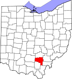
Adjacent counties:
Athens  Gallia  Hocking  Jackson  Meigs  Ross  

Find in Ohio

Map of the Vinton County area


Our detail map of Vinton County shows the Vinton County, Ohio boundary lines and other interesting items.

Places in Vinton County, Ohio

  Airports     show all on map

Vinton County Airport, Zaleski State Forest Landing Strip

  Bridges     show all on map

Cox Bridge, Eakin Mill Bridge, Mount Olive Road Covered Bridge, Ponn Humpback Covered Bridge

  Buildings     show all on map

Dundas Fire Department, Hamden Volunteer Fire Department, Harrison Township Volunteer Fire Department, Herbert Wescoat Memorial Library, Laurelville Fire Department Station 3, McArthur Fire Department, McArthur Police Department, Vinton County Childrens Home, Vinton County Emergency Medical Services, Vinton County Sheriff's Office, Wilkesville Volunteer Fire Department, Zaleski Volunteer Fire Department

  Cemeteries     show all on map

Arbaugh Cemetery, Baker Cemetery, Beard Cemetery, Bell Cemetery, Bethel Cemetery, Bethel Cemetery, Bethel Holiness Mission Cemetery, Blakely Cemetery, Boblett Cemetery, Bolin Cemetery, Bowens Cemetery, Brooks Cemetery, Cassill Cemetery, Centenary Cemetery, Chestnut Grove Cemetery, Clark Cemetery, Creola Cemetery, Cumming Cemetery, Curry Cemetery, Curry Cemetery, Dozer Cemetery, Ebenezer Cemetery, Elk Cemetery, Elk Fork Cemetery, Fairview Cemetery, Fee Cemetery, Garrett Cemetery, Greer Cemetery, Gregory Cemetery, Hamden Cemetery, Harkins Chapel Cemetery, Hixon Cemetery, Keeton Cemetery, Lebanon Cemetery, Locust Grove Cemetery, Log Pile Cemetery, Mace Cemetery, Madison Cemetery, Martindill Cemetery, McGee Cemetery, Mount Olive Cemetery, Mount Pleasant Cemetery, Mount Zion Cemetery, Mount Zion Cemetery, New Plymouth Cemetery, Oak Grove Cemetery, Old Hamden Cemetery, Old McArthur Cemetery, Otterbein Cemetery, Pawpaw Cemetery, Pike Run Cemetery, Pleasant Valley Cemetery, Prattsville Cemetery, Prose Cemetery, Puritan Cemetery, Putnam Chapel Cemetery, Radcliff Cemetery, Randerson Cemetery, Saint Sylvester Cemetery, Salt Spring Cemetery, Scott Cemetery, Shiloh Cemetery, Shoemaker Cemetery, Slagle Cemetery, Slagle Farm Cemetery, Spunk Cemetery, Union Cemetery, Union Ridge Cemetery, Walnut Grove Cemetery, Weaver Chapel Cemetery, Wesley Chapel Cemetery, Wilkesville Cemetery, Williams Cemetery, Wolf Cemetery, Wyckoff Cemetery, Zion Cemetery

  Churches     show all on map

Antioch Church, Bentley Church, Bethel Church, Bethel Church, Bethel Holiness Mission, Boring Church, Centenary Church (historical), Chestnut Grove Church, Church of Jesus Christ, Church of the Nazarene, Corinth Church, Eagle Chapel (historical), Ebenezer Church, Fairview Church, First Christian Church, Friends Church, Hamden United Methodist Church, Harkins Chapel, Hilltop Church, Hope Chapel, Juniper Chapel, Lebanon Church, Log Pile Church, Macedonia Church, Madison Free Will Baptist Church, McArthur Chapel, McArthur United Methodist Church, Minerton Church, Mount Olive Church, Mount Olive Church, Mount Zion Church, Otterbein Chapel, Pike Run Church, Pilgrim Church, Pleasant Chapel (historical), Pleasant Valley Church, Pleasant Valley Church, Pleasant Valley Church, Pleasant Valley Church, Puritan Freewill Baptist Church, Putnam Chapel, Radcliff United Brethren Church, Randerson Church, Saint Pauls Church (historical), Shiloh Church, Trinity Episcopal Church, Union Church, Union Ridge Church, Union Ridge Church, Vinton Chapel, Walnut Grove Church, Weaver Chapel, Welcome Chapel

  Dams     show all on map

Lake Alma Dam, Lake Hope Dam, Lake Rupert Dam, Lankamer Lake Dam, Sproat Lake Dam

  Flats     show all on map

Poplar Flats

  Forests     show all on map

Zaleski State Forest

  Gaps     show all on map

Low Gap

  Lakes     show all on map

Walleye Lake

  Locales     show all on map

Cincinnati Furnace (historical), Eagle Furnace (historical), Hope Furnace, McArthur Junction (historical), Richland Furnace, Vinton Furnace (historical), Wyckoff Crossroads, Zaleski Camp

  Parks     show all on map

Hooper Park, Lake Alma State Park, Lake Hope State Park, Wellston Reservoir State Wildlife Park

  Pillars     show all on map

Lookout Rock

  Populated Places     show all on map

Allensville, Arbaugh, Bee (historical), Bolins Mills, Cintra (historical), Clarion, Cox (historical), Creola, Dundas, Eagle Mills, Ego (historical), Elk Fork, Elko (historical), Fairview (historical), Goosetown (historical), Hamden, Harrison (historical), Hawks, Hope, Hue, Jimtown, Knox, McArthur, Minerton, Mingo (historical), Mount Pleasant, New Plymouth, Oreton, Orland, Ox (historical), Pincher (historical), Prattsville, Puritan, Radcliff, Ratcliffburg, Ray, Red Diamond, Richland, Riley (historical), Royal, Sant (historical), Sheldon (historical), Siverly, Stella, Ural (historical), Vales Mills, Van (historical), Vinton, Washington (historical), Wilkesville, Zaleski

  Reservoirs     show all on map

Lake Alma, Lake Hope, Lake Rupert, Lankamer Lake, Sproat Lake

  Ridges     show all on map

Atkinson Ridge, Bethel Ridge, Cabin Ridge, Fairview Ridge, Furnace Ridge, Garrett Ridge, Irish Ridge, Lake Ridge, Locust Grove Ridge, Log Pile Ridge, Perry Ridge, Pumpkin Ridge, Starrett Ridge, Turner Ridge, Union Ridge

  Schools     show all on map

Allensville Elementary School, Anderson School (historical), Axtel School (historical), Bee School (historical), Beech Grove School (historical), Boblet School (historical), Browns School (historical), Center School (historical), Clark School (historical), Claylick School (historical), Cooney School (historical), Cottrill School (historical), Curry School (historical), Darby School (historical), Dolly School (historical), Eagle School, Ebenezer School (historical), Flat Run School (historical), Greenbrier School (historical), Haburn School (historical), Haburn School (historical), Haggerty School (historical), Hamden Elementary School, Hawk School (historical), Headley School (historical), High Hill School (historical), Jackman School (historical), Kelley School (historical), Miller School (historical), Million School (historical), Mound School (historical), Mount Zion School (historical), Papaw School (historical), Persimmon School (historical), Pine Ridge School (historical), Pleasant Valley School (historical), Ray School (historical), Riley School (historical), Robb School (historical), Seldom Seen School (historical), Shively School (historical), Smallwood School (historical), Swan School, Tar Farm School (historical), Timmons School (historical), Vandiford School (historical), Vinton County Consolidated High School, Whiteoak School (historical), Wilton Elementary School, Zaleski Elementary School

  Streams     show all on map

Alman Run, Brush Fork, Brushy Creek, Brushy Fork, Cox Run, Dry Branch, Dunkle Creek, East Branch Raccoon Creek, Elk Fork, Flat Run, Flat Run, Flatlick Run, Hewett Fork, Hog Run, Indiancamp Run, Johnson Run, Karr Run, Kelley Branch, Laurel Run, Little Sandy Run, Long Run, McConnel Run, Merritt Run, Middle Fork Salt Creek, North Branch Pretty Run, North Fork Brush Fork, Onion Creek, Pierce Run, Pigeon Creek, Pike Run, Pretty Run, Puncheon Fork, Riley Run, Rockcamp Run, Rocky Branch, Russell Run, Sandy Run, Siverly Creek, Speed Run, Stevens Branch, Sugar Run, Tedroe Run, Tripp Run, Twomile Run, West Branch Raccoon Creek, Wheelabout Creek, Wolf Run, Zinns Run

  Summits     show all on map

Dixon Hill, Peck Hill, The Pinnacle

  Towers     show all on map

Atkinson Lookout Tower, Oreton Lookout Tower, WXMF-FM (McArthur)

  Trails     show all on map

Acorn Trail, King Hollow Trail, Old Pine Trail

  Tunnels     show all on map

Moonville

  Valleys     show all on map

Bear Hollow, Big Four Hollow, Black Hollow, Bolster Hollow, Bray Hollow, Brewer Hollow, Brown Hollow, Butler Hollow, Buttermilk Hollow, Clark Hollow, Coalmont Hollow, Conway Hollow, Devils Den Hollow, Fielder Hollow, George Hollow, Good Hollow, Habron Hollow, Harbargar Hollow, Headleg Hollow, Hoagland Hollow, Honeycomb Hollow, Hull Hollow, Jones Hollow, Keeton Hollow, King Hollow, Lipscomb Hollow, Loper Hollow, Mine Hollow, Mitchell Hollow, Mizner Hollow, Morgan Hollow, Ogg Hollow, Parks Hollow, Penrod Hollow, Pierce Hollow, Ponetown Hollow, Reeves Hollow, Rich Hollow, Skunk Hollow, Stony Hollow, Walter Hollow, Webb Hollow, Wildcat Hollow, Wolf Pen Hollow,

Vinton County, Ohio Population By Race (2012 estimate)

RacePopulation
WhiteVinton County White population 12,95912,959  
MixedVinton County Mixed population 159159
American IndianVinton County American Indian population 5353
AsianVinton County Asian population 2726
Hawaiian & Pacific IslanderVinton County Hawaiian & Pacific Islander population 00

Additional population tables :
State population table
Ohio population by county