Crook County, Oregon Basics:


Crook County Oregon - Government Site

Population: 20,666
Area: 2979 square miles
County seat: Prineville
Area code(s) in use: 541
Time zone: PST
High school graduate or higher: 85.4%
Bachelor's degree or higher: 14.4%
Median household income: $40,263
Persons in poverty: 17.4%
Home ownership rate: 72.2%
Mean travel time to work: 21.0 minutes

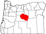
Adjacent counties:
Deschutes  Grant  Harney  Jefferson  Wheeler  

Find in Oregon

Map of the Crook County area


Our detail map of Crook County shows the Crook County, Oregon boundary lines and other interesting items.

Places in Crook County, Oregon

  Airports     show all on map

Cold Spring Guard Station Landing Field, Dry Creek Airpark, Goering Ranches Airport, Pioneer Memorial Hospital Heliport, Prineville Airport, Prineville Bureau of Land Management Heliport, Rager Airstrip, River Run Ranch Airport, Shotgun Ranch Airstrip, Tailwheel Airport

  Basins     show all on map

Conant Basin, Lower Pocket, Rabbit Valley, Sand Hollow, Smith Basin, Trail Basin, Upper Pocket

  Bays     show all on map

Powder House Cove, Roberts Bay

  Buildings     show all on map

A R Bowman Memorial Museum, Bureau of Land Management Prineville District Office, Central Oregon Helitak Prineville Helibase, Crook County Courthouse and Circuit Court, Crook County Fairgrounds Carey Foster Hall, Crook County Fire and Rescue - Juniper Canyon, Crook County Fire and Rescue Main Station, Crook County Fire and Rescue Powell Butte Station, Crook County Health Department, Crook County Jail, Crook County Library, Crook County Sheriff's Office, Department of Motor Vehicles Prineville, Lookout Mountain Ranger Station, Ochoco National Forest Headquarters, Ochoco National Forest Paulina Ranger District, Ochoco National Forrest Ranger Station, Oregon State Forestry District Headquarters, Prineville City Hall, Prineville Police Department, Prineville Public Works Department Office, Prineville Ranger Station (historical), Rimrock Trails Adolescent Treatment Services Treatment Center, United States Forest Service Rager Ranger Station

  Canals     show all on map

Baldwin Ditch, Gill Ditch, Hoffman Ditch, Ochoco Distribution Canal, Ochoco Main Canal, Palmer Ditch, Peoples Irrigation Company Ditch, Pilot Butte North Canal, Pilot Butte South Canal, Ryegrass Ditch, Smith Ditch, Stearns Ditch

  Cemeteries     show all on map

Barnes Cemetery, Beaver Creek Cemetery, Howard Cemetery, Juniper Haven Cemetery, Knox Cemetery, Maury Mountain Cemetery, Mill Creek Cemetery, Roberts Cemetery

  Cliffs     show all on map

Brennan Palisades, Cordella Rim, Dahlgren Rim, Dick Bluff, Grindstone Rim, Hawk Rim, Henry Rim, Juniper Point, Orr Point, Rodman Rim, Rodman Rim, Sherman Rim, Stockade Point, Windy Point, Yreka Rim

  Dams     show all on map

Allen Creek Dam, Antelope Flat Dam, Baldwin Dam, Barnes Butte Dam, Bonnieview Dam, Bowman Dam, Brennan Dam, Camp Creek Dam, Dick Dam, Dry Creek Number Two Dam, Fisher Dam, Gale-Merwin Dam, Grindstone Dam, Hoffman Dam, Johnson Creek Dam, King Dam, Klootchman Creek Dam, Layton Dam Number 2, Lillard Dam, Logan Butte Dam, Long Hollow Dam, Mainline Dam Number 1, Mainline Dam Number 2, Mainline Dam Number 3, Marks Lake Dam, Merwin Dam Number 1, Merwin Dam Number 2, Merwin Dam Number 3, Newsome Creek Dam Number 1, Ochoco Dam, Palmer Dam, Peterson Creek Dam, Pine Creek Dam, Pringle Flat Dam, Rickmans Camp Creek Number 2 Dam, Stearns Dam, Twelve Mile Dam, Twelvemile Dam, Watson Dam

  Falls     show all on map

Lower Falls, Upper Falls

  Flats     show all on map

Alkali Flat, Antelope Flat, Antler Prairie, Big Summit Prairie, Bingham Prairie, Boston Sink, Christiansen Lake, Coffee Lake, Coggins Flat, Combs Flat, Deadline Flat, Dixie Meadows, Dutchman Flat, Flag Flat, Flat Lake, Grant Meadows, Gray Prairie, Grimes Flat, Hickey Meadow, Highland Flat, Horse Prairie, Jake Lakes, Lillie Flat, Little Round Prairie, Little Summit Prairie, Lone Pine Flat, Long Prairie, Lookout Pasture, Lytle Prairie, Miners Flat, Moccasin Prairie, Morris Meadows, Muhly Lake, Porkchop Lake, Roland Lake, Round Prairie, Sandy Lake, Soda Lake, Spears Meadow, Speck Lake, Telephone Flat, Toggle Meadows, Trail Meadow, Wiley Flat, Williams Prairie, Windmill Flat

  Gaps     show all on map

Axtell Gap, Harvey Gap, Kelly Gap, McKay Saddle, Newsome Saddle, Ochoco Pass

  Guts     show all on map

McAllister Slough

  Harbors     show all on map

Prineville Reservoir Resort Marina, Prineville Reservoir State Park Marina

  Hospitals     show all on map

Pioneer Memorial Hospital Prineville

  Islands     show all on map

Big Bend Island

  Lakes     show all on map

Dagus Lake, Double Cabin Pond, Hillside Reservoir, Houston Lake, Jacks Camp Reservoir, Little Houston Lake, Marg Lake, Meadow Reservoir, Miller Lake, Pats Reservoir, Pickett Lake, Spencer Reservoir

  Lava     show all on map

Jones Lava

  Locales     show all on map

Adams Ranch, Allen Creek Horse Camp, Angell Ranch, Antelope Flat Reservoir Boat Launch, Arrow Wood Camp (historical), Badger Cabin, Baker Ranch, Bandit Spring Safety Rest Area, Barney, Barney Ranch, Beoletto Ranch, Bernard Ranch, Big Springs Recreation Site, Biggs Spring Recreation Site, Bingham Prairie Campground, Black Mountain Lookout (historical), Bonnieview Ranch, Bootan Ranch, Breese Ranch, Brennan Ranch, Cabin Guard Station, Canyon Creek Campground, Carey Ranch, Cascades East Transit Prineville Park and Ride, Cayuse Forest Camp, Chimney Rock Campground, Cofelt Ranch, Coffelt Ranch, Cold Spring Ranch, Cold Springs Guard Station, Congleton Ranch, Cougar Forest Camp, Cow Camp, Cow Camp, Cow Camp Cabin, Crook County Fairgrounds, Crook County Fairgrounds Indoor Arena, Crook County Fairgrounds Outdoor Arena, Deep Creek Recreation Site, Demaris Place, Dick Ranch, Divide Cabin, Double Cabin Recreation Site, Durgan Ranch, Elkhorn Recreation Site, Elliot Ranch, Ferian Ranch, G I Ranch, Gill Ranch, Glenn Ranch, H Bernard Ranch (historical), Hackleman Ranch, Hardin (historical), Hardin Ranch, Houston Ranch, Houston Ranch, Howard, Howard Ranch, Humphrey Ranch, Isadore Ranch, Jacks Camp, Jasper Point Boat Ramp, Joe Fisher Ranch, Keystone Ranch, Kizer Ranch, Klaus Ranch, Kuhn Ranch, Lakin Place, Laughlin Ranch, Lister Ranch, Lonesome Spring Campground, Lower Sherman Ranch, Marks Creek Lodge, Maury Guard Station (historical), Mayfield Ranch, Mayflower Mining Settlement (historical), McCormack Ranch, McIntosh Ranch, McKay Creek Forest Camp, Miller Ranch, Miller Ranch, Mills Upper Ranch, Minifie Ranch, Montgomery Spur (historical), Mud Springs Recreation Site, Myers Ranch, Negus Ranch, Nelson Monument, Nye Ranch, O'Neil (historical), Ochocco Lake County Park Boat Ramp, Ochoco Recreation Site, Ochoco Relift Pumping Plant, Ochoco West Sanitary District Sewage Treatment Lagoons, Oregon State Forestry District Headquarters, Palmer Ranch, Paulina Rodeo Grounds, Pine Creek Campground, Ponderosa Substation, Porfily Ranch, Powder House Cove Boat Ramp, Powell Ranch, Prineville and Crooked River National Grassland Headquarters (historical), Prineville Golf and Country Club, Prineville Reservoir County Boat Ramp, Prineville Reservoir Resort, Prineville Reservoir Resort Boat Ramp, Prineville Sewage Treatment Facility, Prinville Reservoir State Park Boat Ramp, Puett Ranch (historical), R Knox Ranch, Red Cloud Ranch, Rickman Ranch, Riverside Ranch, Roberts Bay Boat Launch, Robertson Ranch, Ryegrass Ranch, Sartain Ranch, Saunders Place, Scissorsville, Scotts Recreation Site, Severance Ranch, Sheep Shooter Tree (historical), Shorty Davis Ranch, Slayton Corral, Slayton Spur (historical), Stearns Ranch, Sugar Creek Recreation Site, Symons Wood Camp, Teaters Ranch, Three Spring Ranch, Trail Cabin, Twin Springs Campground, Verges Ranch, Walton Lake Boat Ramp, Walton Lake Campground, Walton Lake Recreation Site, Ward Rhoden Stadium, Way Ranch, Whistler Recreation Site, White Rock Recreation Site, Wildcat Recreation Site, Wiley Flat Recreation Site, Wilton (historical), Windy Acres Dairy Farm, Wolf Creek Recreation Site

  Military     show all on map

Camp Dahlgren (historical), Camp Gibbs (historical), Camp Maury (historical)

  Mines     show all on map

Amity Mine, Bear Creek Agate Beds, Blue Ridge Mine, Independent Mine, Lucky Strike Mine, Maury Mountain Mines, Ochoco Agate Beds, Ochoco Mine, Round Mountain Mine, Valley View Mine

  Parks     show all on map

Antelope Reservoir Recreation Site, Bottero Park, Crooked River Park, Davidson Park, Gary A Ward Park, Harwood Park, Kilowatt Park, Library Park, Lookout Mountain Management Area, Mini Park, Mountain View Park, Ochoco Creek Park, Ochoco Lake State Park, Ochoco State Park, Pioneer Park, Prineville Reservoir State Park, Rimrock Park, Stryker Park

  Pillars     show all on map

Cougar Rock, Eagle Rock, Skookum Rock, Steins Pillar, Twin Pillars

  Populated Places     show all on map

Forest Crossing, Paulina, Post, Powell Butte, Prineville, Roberts, Suplee

  Post Offices     show all on map

Barnes Post Office (historical), Barney Post Office (historical), Coldspring Post Office (historical), Crescent Post Office (historical), Crook Post Office (historical), Drylake Post Office (historical), Fife Post Office (historical), Hardin Post Office (historical), Hat Rock Post Office (historical), Held Post Office (historical), Howard Post Office (historical), Ibex Post Office (historical), Manse Post Office (historical), Meadow Post Office (historical), Mowry Post Office (historical), O'Neil Post Office (historical), Ochoco Post Office (historical), Paulina Post Office, Perham Post Office (historical), Post Post Office, Powell Butte Post Office, Price Post Office (historical), Prineville Post Office, Roberts Post Office (historical), Silver Wells Post Office (historical), Suplee Post Office (historical), Upper Ochoco Post Office (historical)

  Ranges     show all on map

Buck Mountain, Hampton Buttes, Maury Mountains, Ochoco Mountains

  Reserves     show all on map

Mill Creek Wilderness

  Reservoirs     show all on map

Allen Creek Reservoir, Amber Reservoir, Ammons Reservoir, Antelope Flat Reservoir, Antelope Reservoir, Aspen Reservoir, Barnes Butte Reservoir, Battle Ridge Reservoir, Bear Butte Reservoir, Beaverdam Reservoir, Bee Reservoir, Bellworm Reservoir, Bench Reservoir, Bentonite Reservoir, Biddle Reservoir, Blue Jay Reservoir, Bone Reservoir, Boundary Reservoir, Boundary Reservoir, Boundary Reservoir, Brennan Reservoir, Bruner Spring Reservoir, Buck Reservoir, Camp Reservoir, Cary Reservoir, Charity Reservoir, Cinch Reservoir, Clayton Reservoir, Clover Creek Reservoir, Connell Reservoir, Corner Reservoir, Corral Reservoir, Cox Reservoir, Cram Reservoir, Crawford Reservoir, Cross Reservoir, Crossroads Reservoir, Crow Reservoir, Dead End Reservoir, Dick Reservoir, Divide Waterhole, Division Waterhole, Doe Reservoir, Dry Creek Number Two Reservoir, Dry Creek Reservoirs, Dry Reservoir, Duck Puddle Reservoir, Dutch Reservoir, Eagle Reservoir, Eowyn Reservoir, Faith Reservoir, Fawn Reservoir, Flat Reservoir, Fly Reservoir, Foster Reservoir, Fox Reservoir, Frank Reservoir, Freezeout Reservoir, Frog Reservoir, Furnace Waterhole, Gate One Reservoir, Geodetic Reservoir, Gill Reservoir, Gollum Reservoir, Grindstone Reservoir, Halfway Waterhole, Hawk Reservoir, Heisler Reservoir Number One, Heisler Reservoir Number Two, Hickey Reservoir, Hole-in-the-Ground Reservoir, Hook Reservoir, Hope Reservoir, Hornet Reservoir, Horse Heaven Reservoir, Horseshoe Reservoir, Houston Reservoir Number One, Houston Reservoir Number Three, Houston Reservoir Number Two, Ibex Waterhole, Indian Creek Reservoir, Indian Spring Reservoir, Jade Reservoir, Joe Fisher Reservoir, Johnson Creek Reservoir, Jumbuck Reservoir, Juniper Canyon Reservoir, Klootchman Creek Reservoir, Koch Reservoir, Lame Dog Reservoir, Layton Reservoir Number 2, Lillard Lake, Lillard Reservoir, Little Basin Reservoir, Little Juniper Reservoir, Little Lake Waterhole, Logan Butte Reservoir, Long Hollow Reservoir, Long Prairie Reservoir, Looney Reservoir, Lost Spring Reservoir, Lower Coyote Reservoir, Lucky Reservoir, Lutsey Reservoir, Mainline Reservoir Number 1, Mainline Reservoir Number 2, Mainline Reservoir Number 3, Marble Reservoir, Marks Lake, Marshy Reservoir, Meadow Reservoir, Merwin Reservoir Number 1, Merwin Reservoir Number 2, Merwin Reservoir Number Three, Miles Reservoir, Mills Reservoir, Mills Waterhole, Morgan Reservoir, Mud Reservoir, Mudhole Reservoir, Newsome Creek Reservoir Number 1, North Fork Reservoir, O'Henry Reservoir, Ochoco Reservoir, Old Faithful Reservoir, Old Lakebed Waterhole, Owl Reservoir, Packsaddle Reservoir, Palmer Reservoir, Partnership Reservoir, Paulina Reservoir, Peterson Creek Reservoir, Peterson Reservoir, Pine Creek Reservoir, Pine Reservoir, Pine Tree Reservoir, Poley Reservoir, Porcupine Reservoir, Prineville Reservoir, Pringle Flat Reservoir, Reams Reservoir, Reservoir Number Six, Reservoir Twenty-eight, Rickmans Camp Creek Reservoir Number Two, Rimrock Reservoir, Ritch-Fayne Reservoir, Roadside Reservoir, Roadside Reservoir, Robin Reservoir, Rock Spring Reservoir, Ross Reservoir, Rough Canyon Reservoir, Round Prairie Reservoir, Roundtree Lake, Ruby Reservoir, Ryegrass Reservoir, Santry Waterhole, Sartain Reservoir Number Two, Scab Reservoir, Section Eight Reservoir, Shale Reservoir, Sheep Reservoir, Sheep Rock Reservoir, Sheepcamp Reservoir, Shoun Reservoir, Shovel Reservoir, Shumway Lake, South Dagus Reservoir, South Fox Reservoir, Stump Waterhole, Sugar Creek Reservoir, Summit Reservoir, Tamarack Butte Reservoir, Tansy Reservoir, Thompson Reservoir, Thumbtack Reservoir, Tohatin Reservoir, Township Reservoir, Trails End Reservoir, Twelve Mile Reservoir, Twelvemile Reservoir, Twelvemile Reservoir Number Four, Twelvemile Reservoir Number One, Twelvemile Reservoir Number Three, Twelvemile Reservoir Number Two, Twin Springs Reservoir, Upper Coyote Reservoir, Walton Lake, Wasp Reservoir, Watson Reservoir, Westlake Waterhole, Whitney Reservoir, Yancey Reservoir, Yellowjacket Reservoir

  Ridges     show all on map

Ashley Ridge, Barnes Butte, Battle Point, Bradford Ridge, Claypool Ridge, Duck Ridge, Freezeout Ridge, Funeral Ridge, Lakeside Ridge, Logan Ridge, Long Ridge, Lookout Mountain, Lutsey Point, Minifie Ridge, Moccasin Ridge, Mule Deer Ridge, Oberg Ridge, Payne Ridge, Remington Ridge, Rooster Comb, Sabre Ridge, Salem Ridge, Sheepshooter Ridge, South Point, Squirrel Ridge, Steens Ridge, Treichel Ridge, Walker Ridge, Willow Ridge, X X Ridge

  Schools     show all on map

Bailey School (historical), Bear Creek School (historical), Cecil Sly Elementary School, Crook County High School, Crook County Middle School, Crooked River Elementary School, Howard School (historical), Lone Pine School (historical), Mill Creek School (historical), Mount Bachelor Academy, Ochoco Elementary School, Paulina Elementary School, Pioneer Secondary Alternative High School, Post School (historical), Powell Butte Elementary School, Summit Prairie School (historical), Upper McKay School (historical)

  Springs     show all on map

A-Y Spring, Alder Spring, Aldrich Spring, Angus Spring, Antelope Spring, Antelope Spring, Aqua Spring, Aspen Spring, Badger Spring, Bandit Spring, Basin Spring, Bear Spring, Beetle Spring (historical), Berkley Spring, Big Fir Spring, Big Spring, Biggs Spring, Bingham Spring, Blackjoe Spring, Blue Eagle Spring, Board Tree Spring, Bob Spring, Bobcat Spring, Bog Spring, Booton Spring, Bottleneck Spring, Box Spring, Box Spring, Brummer Springs, Bruner Spring, Buck Mountain Spring, Buck Spring, Buck Spring, Bug Spring, Bull Spring, Burnt Corral Spring, Butler Spring, Butte Spring, Cabin Spring, Carwin Spring, Casey Spring, CCC Spring, Cherry Spring, Chev Spring, Chipmunk Spring, Chuckwagon Spring, Claypool Spring, Coin Spring, Colby Spring, Cold Springs, Committee Spring, Cougar Spring, Cox Spring, Coyote Spring, Coyote Spring, Coyote Spring, Cram Spring, Crazy Spring, Crooked Tree Spring, Crow Foot Springs, Crow Spring, Curtis Spring, Cyrus Spring, Daly Spring, Davin Spring, Davis Spring, Delore Spring, Dempsey Spring, Dent Spring, Dingus Spring, Divide Spring, Doby Spring, Dodds Spring, Doe Spring, Donnelly Spring, Dorn Spring, Douthit Springs, Downs Spring, Dozer Spring, Drake Spring, Dublin Spring, Dutchman Spring, East Burnt Log Spring, East Shotgun Spring, East Spring, Federal Spring, Ferguson Spring, Fir Tree Spring, Fisher Spring, Fox Spring, Fox Spring, Frog Spring, Garden Spring, Gerow Spring, Gibson Spring, Gibson Spring, Goldie Spring, Goofy Spring, Grant Spring, Green Spring, Halfway Spring, Hamer Spring, Hamilton Spring, Hammer Creek Spring, Hawthorne Spring, Hegel Spring, Hellebore Spring, Hemp Spring, Hewed Log Spring, Higgins Spring, Hillside Spring, Hon Spring, Horse Spring, Horse Spring, Hunt Spring, Indian Trail Spring, Ingram Spring, J F Spring, Jackalope Spring, Jackson Spring, Jesse Spring, Jones Troughs, Judy Spring, Juniper Basin Spring, Juniper Spring, Juniper Spring, Kemp Spring, Keys Troughs, Kidnap Spring, King Spring, Knox Spring, Knox Spring, Kyle Spring, Lava Point Spring, Lava Spring, Lava Spring, Lightning Spring, Little Happy Spring, Little Horse Spring, Little Spring, Llewelyn Spring, Lodgepole Spring, Lone Pine Spring, Lonesome Spring, Long Spring, Lookout Spring, Lost Spring, Lost Spring, Lower Watson Spring, Lunch Spring, Mahogany Spring, Market Spring, Marks Spring, Maupin Spring, Mayme Spring, McAllister Spring, Monument Spring, Mud Spring, Mud Spring, Mud Spring, Mud Spring, Mule Deer Spring, Noble Garden Spring, O'Neil Spring, Ochillee Spring, Odell Spring, Packsaddle Spring, Paulina Spring, Peter Spring, Picket Spring, Pine Spring, Pipe Spring, Port Spring, Post Spring, Pothole Spring, Price Spring, Quicksand Spring, Rager Spring, Rambo Spring, Rarey Spring, Ray Spring, Rickman Spring, Roba Spring, Rock Spring, Rooster Rock Spring, Rough Spring, Rush Spring, Ruth Spring, Sand Spring, Sand Spring, Sanford Spring, Sawlog Spring, Scab Spring, Scissors Spring, Section 11 Spring, Seeley Spring, Sera Spring, Shangri-la Spring, Shearing Spring, Sheep Rock Spring, Sherwood Spring, Shown Troughs, Skelton Spring, Skull Spring, Slow Spring, Snyder Spring, Soap Spring, Soda Spring, Soda Spring, Statz Spring, Stewart Spring, Stove Spring, Strickland Spring (historical), Stump Spring, Sugar Creek Spring, Sulphur Spring, Sunny Slope Springs, Sunny Slope Springs, Swamp Spring, Swamp Spring, Tamarack Spring, Tamarack Spring, Teater Spring, Telephone Springs, Three C Spring, Tom Spring, Tom Vawn Spring, Tub Spring, Twin Springs, Upper Ray Spring, Veason Spring, Wade Spring, Wasp Spring, Watson Spring, Wells Spring, West Burnt Log Spring, West Shotgun Spring, Whiskey Spring, Whistler Spring, White Fir Spring, White Rock Spring, Whitetail Spring, Wickheiser Spring, Widow Spring, Wildhorse Spring, Williams Spring, Willow Springs, Wilson Spring, Woodin Spring, Yu-ma Spring, Zane Spring

  Streams     show all on map

Ahalt Creek, Alkali Creek, Alkali Creek, Allen Creek, Allen Creek, Ant Creek, Antelope Creek, Bear Creek, Bear Creek, Beaver Creek, Beaverdam Creek, Beetle Creek, Belknap Creek, Benefield Creek, Big Spring Creek, Black Snag Creek, Black Stump Creek, Blevins Creek, Boardtree Creek, Bogue Creek, Brogan Creek, Bronco Creek, Brown Creek, Brush Creek, Buck Creek, Buck Creek, Buck Creek, Buck Hollow Creek, Bull Creek, Burn Creek, Burnt Corral Creek, Cadle Creek, Cady Creek, Camp Branch, Camp Creek, Camp Creek, Camp Creek, Canyon Creek, Cemetery Creek, Cline Creek, Clover Creek, Clover Creek, Coffee Creek, Committee Creek, Conant Creek, Cornez Creek, Cougar Creek, Cow Creek, Coyle Creek, Cram Creek, Crazy Creek, Crosswhite Creek, Crusher Creek, Crystal Creek, Cuitan Creek, Deadman Creek, Deep Creek, Deer Creek, Deer Creek, Deer Creek, Dick Creek, Dipping Vat Creek, Doe Creek, Donnelly Creek, Double Cabin Creek, Douthit Creek, Drake Creek, Dry Creek, Dry Creek, Dry Paulina Creek, Dry Porter Creek, Dry River, Dry Rock Creek, Dudley Creek, Duncan Creek, Dutchman Creek, Eagle Creek, East Fork Elliot Creek, East Fork Foley Creek, East Fork Howard Creek, East Fork Mill Creek, East Porter Creek, Elliot Creek, Elliott Slough, Evans Creek, Fall Creek, Faught Creek, Fawn Creek, Ferguson Creek, Fintcher Creek, Fisher Creek, Florida Creek, Fox Canyon Creek, Fox Creek, Friday Creek, Garden Creek, Gibson Creek, Grant Creek, Gray Creek, Grindstone Creek, Hail Creek, Hamer Creek, Hamilton Creek, Hammer Creek, Hampton Creek, Harvey Creek, Hash Rock Creek, Hedgepath Creek, Heflin Creek, Heisler Creek, Hewed Log Creek, Hickey Creek, Hide Canyon, Home Hollow Creek, Horse Heaven Creek, Howard Creek, Indian Creek, Indian Creek, Indian Creek, Indian Trail Creek, Jackson Creek, Japanese Creek, Jim Elliott Creek, Johnson Creek, Johnson Creek, Judy Creek, Jungle Creek, Juniper Creek, Keeney Creek, Kelly Creek, Keys Creek, Klootchman Creek, Kuiman Creek, Kyle Creek, Lake Fork, Lame Dog Creek, Lawson Creek, Lemon Creek, Little Bear Creek, Little Deer Creek, Little Hay Creek, Little Horse Heaven Creek, Little McKay Creek, Little Summit Creek, Lodgepole Creek, Lofton Creek, Lone Pine Creek, Long Hollow Creek, Long Hollow Creek, Lookout Creek, Looney Creek, Lost Creek, Lucky Creek, Lytle Creek, Lytle Creek, Madison Creek, Marks Creek, Maury Creek, McAllister Creek, McGinnis Creek, McKay Creek, Meadow Branch, Mercury Creek, Merritt Creek, Metal Creek, Middle Fork Camp Creek, Miles Creek, Mill Creek, Mule Creek, Nature Creek, Newsome Creek, Norcross Creek, North Fork Bear Creek, North Fork Beaver Creek, North Fork Crooked River, North Fork Trout Creek, North Fox Canyon Creek, North Wolf Creek, O'Neil Creek, O'Neil Creek, Ochoco Creek, Old Dry Creek, Owl Creek, Parrish Creek, Paulina Creek, Peaslee Creek, Perry Creek, Peterson Creek, Peterson Creek, Pine Creek, Pine Stub Creek, Poison Creek, Pole Creek, Polie Creek, Polly Creek, Poppy Creek, Porter Creek, Powell Creek, Pringle Creek, Rager Creek, Rail Creek, Rail Creek, Reilly Creek, Riley Creek, Roba Creek, Rock Creek, Ross Creek, Rough Canyon Creek, Rush Creek, Salmon Creek, Salt Creek, Sand Creek, Sand Hollow Creek, Sanford Creek, Schoolhouse Creek, Scissors Creek, Scotty Creek, Sealy Creek, Sears Creek, Shady Creek, Shamrock Creek, Sheep Creek, Sheep Rock Creek, Sherwood Creek, Short Creek, Shotgun Creek, Soldier Creek, South Fork Beaver Creek, South Fork Crooked River, South Fork Howard Creek, South Fork Trout Creek, Spring Creek, Spring Creek, Spring Creek, Stewart Creek, Stump Creek, Stupid Creek, Sugar Creek, Swamp Creek, Swamp Creek, Tamarack Creek, Tamarack Creek, Thorn Creek, Thornton Creek, Tom Vawn Creek, Trout Creek, Twelvemile Creek, Veazie Creek, Warm Springs Creek, Watson Creek, West Fork Camp Creek, West Fork Crazy Creek, West Fork Fox Creek, West Fork Howard Creek, West Fork Mill Creek, West Fork Trout Creek, West Thornton Creek, White Butte Creek, Whitney Creek, Wickiup Creek, Widow Creek, Wildcat Creek, Wildcat Creek, Wiley Creek, Williamson Creek, Willow Creek, Winter Creek, Wolf Creek, Wolf Creek, Yellowjacket Creek

  Summits     show all on map

Alkali Butte, Angell Butte, Ann Butte, Arrowwood Point, Bear Butte, Bear Creek Butte, Big Rattlesnake Butte, Big Table, Birdsong Butte, Black Mountain, Bull Mountain, Cabin Butte, Cadle Butte, Chimney Rock, Coffee Butte, Colpitts Butte, Cougar Butte, Cougar Rock, Cougar Rock, Coyle Butte, Coyote Butte, Dorschied Butte, Drake Butte, Duncan Butte, Elkins Butte, Faulkner Butte, Foley Butte, Forbes Butte, Forked Horn Butte, Gerow Butte, Gerry Mountain, Grant Butte, Grass Butte, Grass Butte ck rcd data, Green Mountain, Grizzly Mountain, Hamilton Butte, Hash Rock, Hat Rock, Hawkins Butte, Homestead Butte, Horse Butte, Houston Butte, Howard Butte, Ibex Butte, Indian Butte, Ingram Point, Iron Mountain, Isadore Butte, Joe Butte, Juniper Butte, Kid Peak, Koch Butte, Laughlin Table, Line Butte, Little Table Mountain, Logan Butte, Lucky Butte, Mackey Butte, Magpie Butte, Mahogany Butte, Maupin Butte, Milk Butte, Milliorn Hill, Mills Butte, Moon Mountain, Mud Spring Butte, Myers Butte, North Point, O'Neil Butte, Paulina Butte, Pilot Butte, Pine Mountain, Polk Butte, Pollard Butte, Powell Buttes, Powell Mountain, Powell Valley Butte, Prairie Hill, Rattlesnake Butte, Roba Butte, Rocky Butte, Rooster Rock, Round Butte, Round Mountain, Ruby Butte, Ryegrass Table, Saddle Butte, Salt Butte, Scareoff Point, Shaw Table, Sheep Creek Butte, Sheep Rock, Smoky Butte, Soda Table, South Fork Hill, Speckle Butte, Stearns Butte, Sugarloaf Butte, Sulphur Spring Butte, Tamarack Butte, Taylor Butte, Tower Point, Twelvemile Table, Valpey Butte, View Point, Wade Butte, Weberg Butte, West Butte, Whistler Point, Wildcat Mountain, Willow Butte, Winter Butte, York Butte

  Swamps     show all on map

Logan Reservoir, Timothy Meadow

  Towers     show all on map

Foley Butte Lookout Tower, Gerow Butte Lookout Tower, KIJK-FM, KRCO-AM

  Valleys     show all on map

Allyn Draw, Bedell Canyon, Bellworm Canyon, Birch Canyon, Box Canyon, Bracket Canyon, Buck Hollow, Desolation Canyon, Devils Canyon, Gravy Gulch, Grizzly Mountain Canyon, Hewed Log Hollow, Horse Gulch, Juniper Canyon, Juniper Canyon, Juniper Canyon, Lincoln Canyon, Long Hollow, Monroe Draw, Mud Spring Canyon, Norman Canyon, Odell Hollow, Oscar Canyon, Paulina Valley, Powell Valley, Prineville Valley, Pringle Gulch, Putnam Gulch, Rail Canyon, Rocky Canyon, Rough Canyon, Sage Hollow, Sawtell Canyon, Sheep Head Canyon, Smith Canyon, Swartz Canyon, Taylor Gulch, The Cove, Water Trough Canyon, Watkins Hollow, Yank Gulch

  Wells     show all on map

Government Well, Noble Well, Sand Hollow Well, Sera Well,

Crook County, Oregon Population By Race (2012 estimate)

RacePopulation
WhiteCrook County White population 19,79819,798  
MixedCrook County Mixed population 413413
American IndianCrook County American Indian population 289289
AsianCrook County Asian population 124123
BlackCrook County Black population 4141
Hawaiian & Pacific IslanderCrook County Hawaiian & Pacific Islander population 2120

Additional population tables :
State population table
Oregon population by county