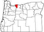
Hood River County, Oregon Basics:


Hood River County Oregon - Government Site

Population: 22,597
Area: 522 square miles
County seat: Hood River
Area code(s) in use: 541
Time zone: PST
High school graduate or higher: 82.3%
Bachelor's degree or higher: 26.4%
Median household income: $56,355
Persons in poverty: 10.1%
Home ownership rate: 68.5%
Mean travel time to work: 16.4 minutes


Adjacent counties:
Clackamas  Klickitat (WA)  Multnomah  Skamania (WA)  Wasco  

Find in Oregon

Map of the Hood River County area


Our detail map of Hood River County shows the Hood River County, Oregon boundary lines and other interesting items.

Places in Hood River County, Oregon

  Airports     show all on map

Cascade Locks State Airport, Green Acres Air Park, Hanel Field Airport, Hood River Fire Department Heliport, Ken Jernstedt Airfield, United Telephone System Airstrip

  Areas     show all on map

Cloud Cap-Tilly Jane Historic Area, Old Wagon Road Historical Area

  Basins     show all on map

Cairn Basin, Devils Kitchen, Dukes Valley, Eden Park, Elk Cove, Middle Valley, Wy'east Basin

  Bays     show all on map

Government Cove, Ruthton Cove

  Beaches     show all on map

Koberg Beach

  Bridges     show all on map

Bridge of the Gods, Dry Run Bridge, Four One Half Mile Bridge, High Bridge, Tucker Bridge

  Buildings     show all on map

Cascade Locks City Hall, Cascade Locks Department of Public Works, Cascade Locks Fire and Emergency Medical Services, Cascade Locks Historical Museum, Cascade Locks Municipal Court, Cloud Cap Inn, Columbia Center for the Arts, Dee Rural Fire Protection District, Department of Motor Vehicles Hood River, Hood River City Hall, Hood River City Police Department, Hood River County Justice Court, Hood River County Library, Hood River County Library Cascade Locks Branch, Hood River County Library Parkdale Branch, Hood River County Public Works Department, Hood River County Sheriff's Office, Hood River Fire and Emergency Medical Services, Hood River Municipal Court, Hood River Public Health Department, Hood River Public Works Department, Huston Museum, Lost Lake Ranger Station, Mount Hood National Forest Hood River Ranger District Hood River Ranger Station, Odell Rural Fire Protection District, Parkdale Rural Fire Protection District, Parkdale Rural Fire Protection District Station 2, Pine Grove Rural Fire Protection District, The History Museum of Hood River County, United States Forest Service Hood River Ranger District, Western Antique Aeroplane and Automobile Museum, Westside Rural Fire Protection District Station 1, Westside Rural Fire Protection District Station 2

  Canals     show all on map

Central Lateral, Dee Flat Ditch, East Fork Main Canal, Farmers Ditch, Glacier Ditch, Highline Lateral, Low Line Ditch, Mount Hood Canal, Neal Creek Lateral, Oak Grove Ditch, Power Canal, Volmer Ditch

  Capes     show all on map

Anderson Point, Mitchell Point, Ruthton Point, Trotter Point

  Cemeteries     show all on map

Cascade Locks Cemetery, Cushman's Pasture Cemetery, Frankton Cemetery, Freddie Masterson Grave, George W Weart Grave, Harry Wollam Grave, Homesteader Grave, Hood River County Cemetery, Idlewilde Cemetery, Jackson Family Cemetery, John G Fischer Grave, McIsaac Ranch Cemetery, Mount Hood Community Cemetery, Mountain View Memorial Cemetery, Oak Grove Cemetery, Pine Grove Butte Cemetery, Saint Mark the Evangelist Church Columbarium, Saint Mary's Cemetery, Shelley Family Cemetery, Upper Valley Cemetery, Viento Cemetery, Wyeth Cemetery

  Census     show all on map

Mount Hood Census Designated Place, Odell Census Designated Place, Parkdale Census Designated Place

  Channels     show all on map

Cook Point Range Channel, Little White Salmon Range Channel, Wind Mountain Lower Range Channel

  Churches     show all on map

Cascade Chapel Assembly Of God, First Baptist Church, Hood River Alliance Church, Immanuel Lutheran Church, Parkdale Baptist Church, Parkdale Church of the Nazarene, Pine Grove-Odell United Methodist Church, Tucker Road Baptist Church

  Cliffs     show all on map

Pulpit Rock, Steel Cliff

  Dams     show all on map

Badger Lake Dam, Clear Branch Dam, Lower Green Point Dam, Powerdale Dam, Upper Green Point Dam

  Falls     show all on map

Lancaster Falls, Loowit Falls, Metlako Falls, Punch Bowl Falls, Punchbowl Falls, Sahale Falls, Switchback Falls, Tamanawas Falls, Tunnel Falls, Umbrella Falls, Wah Gwin Gwin Falls, Wallalute Falls, Warren Creek Falls

  Flats     show all on map

Batts Meadow, Bonney Meadows, Bottle Prairie, Brooks Meadow, Cooks Meadow, Crane Prairie, Dee Flat, Devils Half Acre Meadow, Eightmile Meadow, Elk Meadows, Gibson Prairie, High Prairie, Hood River Meadows, Horkelia Meadow, Horsethief Meadows, Long Prairie, Round Prairie, Willow Flat

  Gaps     show all on map

Barlow Pass, Bennett Pass, Bingen Gap, Gumjuwac Saddle, Lolo Pass

  Glaciers     show all on map

Coalman Glacier, Coe Glacier, Eliot Glacier, Glisan Glacier, Ladd Glacier, Langille Glacier, Newton Clark Glacier, White River Glacier

  Harbors     show all on map

Port of Cascade Locks Marina, Port of Hood River Marina Park, Waucoma Basin Marina

  Hospitals     show all on map

Providence Hood River Memorial Hospital

  Islands     show all on map

Thunder Island, Wells Island

  Lakes     show all on map

Bear Lake, Black Lake, Dollar Lake, Dublin Lake, Hicks Lake, Indian Lake, Koberg Slough, Lost Lake, Mud Lake, North Lake, Ottertail Lake, Oval Lake, Perry Lake, Rainy Lake, Recession Lakes, Scout Lake, Teacup Lake, Thrush Pond, Wahtum Lake, Warren Lake

  Locales     show all on map

Badger Lake Recreation Site, Bald Mountain Shelter, Barlow Guard Station, Bloucher (historical), Blue Grouse Campsite (historical), Bonney Meadows Recreation Site, Boulder Lake Recreation Site, Brooks Meadow Guard Station, C L Lumber Company, Camp 1 (historical), Camp Windy Recreation Site, Camp Yallani, Cascade Locks Waste Water Treatment, Cascade Rapids Lower Range Light, Cedar Swamp Campsite (historical), Clifton, Clinger Campground, Cloud Cap Saddle Recreation Site, Columbia Area Transit Office Dispatch and Garage, Columbia Gorge Work Center, Conway (historical), Cooper Spur Ski Area, Deadwood Camp, Dee Flat Guard Station, Dee Flat Seed Orchard, Devils Half Acre Meadow Recreation Site, Dukes Valley (historical), Farley (historical), Frankton, Gibson Prairie Horse Camp, Grandview (historical), Herman Creek Horse Camp, Holstein (historical), Hood River County Fairgrounds, Hood River Golf Course, Hood River Hatchery, Hood River Waste Water Treatment, Hood River Waterfront Park Amphitheatre, Hunters Camp, Kingley Campground Boat Ramp, Kinnikinnick Recreation Site, Kiyokawa Family Orchards, Ladd Creek Campground, Laurance Lake Boat Ramp, Lindsey (historical), Lost Creek Recreation Site, Lost Lake Boat Ramp, Lost Lake Recreation Site, Meno, Mid Columbia Agricultural Experiment Station, Mohr (historical), Moore Orchards, Mount Hood Meadow Ski Area, Mount Hood Meadows Oregon Wastewater Treatment Plant, Neal Creek Orchard and Gardens, Nottingham Campground, Odell Sanitary District, Oxbow Hatchery, Parkdale Sewer Treatment Plant, Port of Cascade Locks Boat Ramp, Port of Hood River Boat Ramp, Powerdale (historical), Rainy Lake Recreation Site, Rasmussen Farms, Red Hill Guard Station, Reservoir Campground, Ridge Camp, Robinhood Guard Station, Robinhood Recreation Site, Ruthton (historical), Sears (historical), Seven-and-a-Half Mile Campsite (historical), Seven-and-a-Half Mile Campsite (historical), Shell Rock (historical), Sherwood Recreation Site, Sonny (historical), Summit, Switchback, Tenas Camp (historical), The Dalles City Waterworks, Tilly Jane Guard Station, Tilly Jane Recreation Site, Trout Creek, Valley View Cabin, Van Horn, Viento (historical), Wahtum Lake Guard Station, Wahtum Lake Recreation Site, Wasco Light, White River Park Campground, Winans, Windmaster Corner, Woodworth (historical), Wy'East Campsite (historical), Wyeth, Wyeth Recreation Site

  Parks     show all on map

Coe Park, Columbia Gorge Recreation Area, Eliot Park, Historic Columbia River Highway State Trail, Indian Springs Campground (historical), Jackson Park, Kingsley Reservoir County Park, Koberg Beach State Park, Lang Forest State Park, Lindsey Creek State Park, Mann Park, Morrison Park, Oak Grove County Park, Panorama Point County Park, Polallie Campground (historical), Port Marina Park, Routson County Park, Ruthton County Park, Seneca Fouts Memorial State Park, Starvation Creek State Park, Toll Bridge County Park, Tollbridge Park, Tucker County Park, Viento State Park, Vinzenz Lausmann Memorial State Natural Area, Waucoma Park, Wilson Park, Winans Park, Wyeth State Park, Wygant State Natural Area, Ziba Dimmick State Park (historical)

  Pillars     show all on map

Indianhead Rock, Stanley Rock, The Chimney, The Pinnacle

  Plains     show all on map

Benson Plateau

  Populated Places     show all on map

Cascade Locks, Dee, Hood River, Lenz, Lost Lake Resort, Mount Hood, Oak Grove, Odell, Parkdale, Pine Grove, Rockford

  Post Offices     show all on map

Cascade Locks Post Office, Dee Post Office (historical), Fir Post Office (historical), Hood River Post Office, Menominee Post Office (historical), Mount Hood Post Office (historical), Mount Hood-Parkdale Post Office, Odell Post Office, Parkdale Post Office (historical), Shell Rock Post Office (historical), Straightsburg Post Office (historical), Tucker Post Office (historical), Viento Post Office (historical), Wyeth Post Office (historical)

  Reserves     show all on map

Cascade Locks Treaty Fishing Access Site, Mark O Hatfield Wilderness, Stanley Rock Treaty Fishing Access Site

  Reservoirs     show all on map

Aubert Reservoir, Badger Lake, Buehler Pond, Duckwall Reservoir, Emil Creek Reservoir, Green Point Lower Reservoir, Green Point Upper Reservoir, Jean Lake, Laurance Lake, Lindsey Pond, Searra Casa Reservoir

  Ridges     show all on map

Bald Mountain Ridge, Barlow Ridge, Barrett Spur, Blowdown Ridge, Blue Ridge, Bluegrass Ridge, Booth Hill, Butcher Knife Ridge, Cathedral Ridge, Cooper Spur, Ghost Ridge, Gnarl Ridge, Inspiration Point, Langille Crags, Middle Mountain, Mill Creek Buttes, Nick Eaton Ridge, Rim Rock, Stranahan Ridge, Surveyors Ridge, Triangle Moraine, Trout Creek Ridge, Viento Ridge, Vista Ridge, Waucoma Ridge, Woolly Horn Ridge

  Schools     show all on map

Cascade Locks School, Frankton School (historical), Hood River Middle School, Hood River Valley High School, Horizon Christian School, May Street Elementary School, Mid Valley Elementary School, Mid-Columbia SDA School, Parkdale Elementary School, Pine Grove Elementary School, Westside Elementary School, Wy'East Middle School

  Springs     show all on map

Agnes Spring, Bear Wallow Springs, Beaver Spring, Big Cedar Springs, Birdseye Spring, Blue Bucket Spring, Capron Spring, Cascade Spring, Clinger Spring, Cold Springs, Crystal Spring, Crystal Spring, Crystal Springs, Dago Spring, Davis Spring, Dead Point Spring, Dog River Springs, East Spring, Elk Bed Springs, English Spring, Gibson Spring, Government Spring, Graham Spring, Guttery Spring, Hakel Spring, Hannum Spring, Ice Fountain Spring, Indian Springs, Jack Springs, Japanese Springs, Johnson Spring, Kane Springs, Lava Springs, Lone Pine Spring, McGuire Spring, Minott Spring, Moody Spring, Old Schoolhouse Spring, Parkdale Cold Spring, Parker Springs, Perham Creek Spring, Poplar Spring, Powder Springs, Rhoades Spring, Roaring Camp Spring, Rogers Spring, Salvation Spring, Sanford Spring, Savage Springs, Senecal Spring, Shelley Springs, Shellrock Spring, Shinners English Spring, Smith Spring, Smokey Spring, Sparks Spring, Stone Spring, Stroud Springs, Teakettle Spring, Tucker Spring, White Horse Spring, Winan Spring

  Streams     show all on map

Alder Brook, Alder Creek, Ash Creek, Baldwin Creek, Bear Creek, Beaver Creek, Birdie Creek, Boomer Creek, Buck Creek, Buck Point Creek, Cabin Creek, Camp Creek, Camp Creek, Campbell Creek, Casey Creek, Cat Creek, Cedar Branch, Cedar Creek, Clark Creek, Clear Branch, Coe Branch, Cold Spring Creek, Collins Creek, Compass Creek, Crystal Spring Creek, Culvert Creek, Dead Point Creek, Ditch Creek, Ditch Creek, Divers Creek, Doe Creek, Dog River, Drop Creek, Dry Creek, Dry Run, East Fork Eagle Creek, East Fork Herman Creek, East Fork Hood River, Eliot Branch, Elk Creek, Emil Creek, Engineers Creek, Evans Creek, Fall Creek, Ferguson Creek, Flume Creek, Fret Creek, Gate Creek, Goat Creek, Gorton Creek, Graham Creek, Grays Creek, Green Apple Creek, Green Point Creek, Griswell Creek, Gumjuwac Creek, Harphan Creek, Hazel Creek, Hellroaring Creek, Henderson Creek, Herman Creek, Hood River, Indian Creek, Indian Creek, Inlet Creek, Iron Creek, Jalland Creek, Jones Creek, Kershaw Creek, Ladd Creek, Lake Branch, Laurel Creek, Lenz Creek, Lindsey Creek, Little Creek, Little Herman Creek, Long Branch Creek, Lunch Creek, Marco Creek, McGee Creek, Meadows Creek, Middle Fork Hood River, Midget Creek, Mine Creek, Mineral Creek, Mitchell Creek, Moody Creek, Mosquito Creek, Mullinix Creek, Neal Creek, Newton Creek, No Name Creek, North Fork Cold Spring Creek, North Fork Green Point Creek, North Fork Iron Creek, North Fork Mineral Creek, Odell Creek, Opal Creek, Palmateer Creek, Perham Creek, Phelps Creek, Pine Creek, Pine Creek, Pinnacle Creek, Pocket Creek, Polallie Creek, Puppy Creek, Red Hill Creek, Rhoades Creek, Rimrock Creek, Robinhood Creek, Rock Creek, Rogers Creek, Ruckel Creek, Rudolph Creek, Shelley Creek, Shelly Creek, Shingle Creek, Simmons Creek, Skipper Creek, Slide Creek, Snakehead Creek, Sorenson Creek, South Fork Cold Spring Creek, South Fork Iron Creek, South Fork Mineral Creek, South Pine Creek, Spring Creek, Squeegee Creek, Starvation Creek, Stump Creek, Summit Creek, Tilly Jane Creek, Tish Creek, Tolo Creek, Tony Creek, Trout Creek, Tumble Creek, Tumbledown Creek, Viento Creek, Ward Creek, Warren Creek, Washout Creek, West Fork Evans Creek, West Fork Hood River, West Fork Neal Creek, Whiskey Creek, Whisky Creek, Wisehart Creek, Wonder Creek, Yellowjacket Creek

  Summits     show all on map

Badger Butte, Bald Butte, Bald Mountain, Barlow Butte, Bonney Butte, Butcher Peak, Chinidere Mountain, Davidson Hill, Dead Point, Devils Pulpit, Echo Point, Elk Mountain, Erk Hill, File Butte, Fir Mountain, Green Point Mountain, Gunsight Butte, Hood River Mountain, Indian Mountain, Lamberson Butte, Lenz Butte, Lookout Mountain, Lost Lake Butte, Mount Defiance, Mount Hood, Panorama Point, Perry Point, Raker Point, Red Hill, Sawtooth Mountain, Sentinel Peak, Shellrock Mountain, Shellrock Mountain, Sunshine Rock, Tomlike Mountain, Van Horn Butte

  Towers     show all on map

KCGB-FM, KIHR-AM

  Trails     show all on map

Blue Bucket Trail, Boulder Lake Trail, Boulder Lake Way Trail, Cooper Spur Ski Trail, Dog River Trail, Eagle Creek Trail, Eagle Tanner Trail, Elk Grove Trail, Elk Meadows Trail, Flag Point Trail, Gnarl Ridge Trail, Herman Creek Trail, Huckleberry Mountain Trail, Lamberson Butte Spur Trail, Lookout Mountain Trail, Lost Lake Butte Trail, Pine Creek Trail, Pinnacle Ridge Trail, Stump Creek Trail, Tilly Jane Trail, Timberline Trail, Umbrella Falls Trail, Vista Ridge Trail, Wyeth Trail, Wygant Trail, Zigzag Trail

  Valleys     show all on map

Hood River Valley, Hutson Gulch, Post Canyon, Sand Canyon, Upper Hood River Valley, Weygandt Canyon,

Hood River County, Oregon Population By Race (2012 estimate)

RacePopulation
WhiteHood River County White population 21,26421,263  
MixedHood River County Mixed population 542542
AsianHood River County Asian population 339338
American IndianHood River County American Indian population 249248
BlackHood River County Black population 158158
Hawaiian & Pacific IslanderHood River County Hawaiian & Pacific Islander population 4545

Additional population tables :
State population table
Oregon population by county