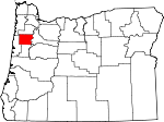
Polk County, Oregon Basics:


Polk County Oregon - Government Site

Population: 76,331
Area: 741 square miles
County seat: Dallas
Area code(s) in use: 503
Time zone: PST
High school graduate or higher: 89.9%
Bachelor's degree or higher: 28.5%
Median household income: $52,365
Persons in poverty: 14.6%
Home ownership rate: 66.8%
Mean travel time to work: 24.3 minutes


Adjacent counties:
Benton  Lincoln  Linn  Marion  Tillamook  Yamhill  

Find in Oregon

Map of the Polk County area


Our detail map of Polk County shows the Polk County, Oregon boundary lines and other interesting items.

Places in Polk County, Oregon

  Airports     show all on map

Andersons Airfield, Cascade Airstrip, Faust Field Airport, George Airport, Independence State Airport, Joe Cards Airpark, JPM Airport, Marr Field Airport, Morlan Airfield, S and E Farms Independence Airstrip, Steel Systems Airstrip, Vineyard Airport, Wigrich Airfield

  Bars     show all on map

Darrow Bar, Darrow Rocks, Judson Rocks, Lincoln Rocks, Murphy Bar, Whiteman Bar, Windsor Bar

  Basins     show all on map

Socialist Valley

  Bridges     show all on map

Davidson Bridge, Ritner Creek Bridge, Wallace Bridge

  Buildings     show all on map

American Red Cross Willamette Chapter Headquarters, Amity Fire District, Confederated Tribes of Grand Ronde, Dallas City Hall, Dallas Fire Department, Dallas Municipal Courthouse, Dallas Police Department, Dallas Public Library, Dallas Public Works, Department of Motor Vehicles Dallas, Falls City City Hall, Falls City Community Building and Municipal Courthouse, Falls City Fire Department, Falls City Public Works, Farmers Union Hall, Heritage Museum, Independence City Hall, Independence Municipal Courthouse, Independence Police Department, Independence Public Library, Independence Public Works, Jensen Artic Museum, Monmouth City Hall, Monmouth Municipal Courthouse, Monmouth Police Department, Monmouth Public Library, Monmouth Public Works, Pentacle Theatre, Polk County Courthouse, Polk County Fire District 1 Station 40 Buena Vista, Polk County Fire District 1 Station 70 Pedee, Polk County Fire District 1 Station 80, Polk County Fire District 1 Station 90, Polk County Jail, Polk County Museum, Polk County Public Health Department, Polk County Public Works, Polk County Sheriff's Office, Salem Fire Department Station 5, Sheridan Fire District Substation Ballston, Sheridan Fire District Substation Buell, Southwest Polk County Rural Fire Protection District Station 110, Southwest Polk County Rural Fire Protection District Station 120, Southwest Polk County Rural Fire Protection District Station 130, Wagner Community Library, West Salem Branch Library, West Valley Fire District Substation, Western Oregon University Rice Auditorium

  Cemeteries     show all on map

Ball Cemetery, Bethel Cemetery, Brown Cemetery, Buena Vista Cemetery, Butler Davidson Cemetery, Cemetery Hill Cemetery, Claremont Cemetery, Dallas Cemetery, Edwards Pioneer Cemetery, Embree Cemetery, Etna Cemetery, Falls City Cemetery, Falls City Odd Fellows Cemetery, Fast Cemetery, Fircrest Cemetery, Hart Riggs Cemetery, Hubbard Cemetery, Hussey Cemetery, Indian Cemetery, Mennonite Cemetery, Montgomery Cemetery, Pedee Cemetery, Pleasant Hill Cemetery, Rest Lawn Memory Gardens, Salt Creek Cemetery, Schrag Cemetery, Smith Cemetery, Taylor Cemetery, Union Baptist Cemetery, Willamina Cemetery, Williams Cemetery, Womer Cemetery, Zena Cemetery

  Census     show all on map

Eola Census Designated Place, Fort Hill Census Designated Place, Grand Ronde Census Designated Place, Rickreall Census Designated Place

  Channels     show all on map

Darrow Chute, Windsor Island Reach

  Churches     show all on map

Bethel Community Church, Buena Vista Community Church, Dallas Alliance Church, Faith Evangelical Free Church, Kingwood Bible Church, Living Word Faith Fellowship, Monmouth Evangelical Church, Old German Brethren Church, Saint Patricks Church, West Hills Community Church

  Dams     show all on map

Croft Dam, Dejong Dam, Earl Kennel Dam, Ingebrand Dam, Joe Crow Dam, Martin Brothers Flashboard Dam, Marvin Fast Dam, Marx Dam, Mercer Dam, Morgan Brothers Dam, Mountain Springs Ranch Dam, Oak Crest Farm Dam, Ornoname 21 Dam, Ornoname 9 Dam, Reimer Dam, Rohde Dam, Valsetz Lake Dam (historical), Walker Dam Number Two, Wendell Kreder Dam

  Falls     show all on map

Berry Creek Falls, Silver Falls

  Flats     show all on map

American Bottom, Buckskin Flat, Red Prairie

  Forests     show all on map

George T Gerlinger State Experimental Forest

  Gaps     show all on map

Big Saddle, Boulder Pass, Chandler Pass, Holmes Gap, Indian Gap, Millers Gap

  Hospitals     show all on map

West Valley Hospital

  Islands     show all on map

Hayden Island, Rice Rocks, Wells Island

  Lakes     show all on map

Crider Pond, Downing Pond, Hayden Lake, Humbug Lake, Jones Pond, Lamer Pond, Lewis Pond, Osborn Pond, Peters Pond, Solle Ponds

  Locales     show all on map

Arell (historical), Blooming Dales Pony Farm, Boulder Camp, Brophy (historical), Brunks Corner, Buena Vista Ferry Landing West, Buman, Buman Quarry (historical), Burns Corner, Butler (historical), Byerley Corner, Calvert (historical), Camp 2 (historical), Camp Kilowan, Camp Russell, Camp Tapawingo, Camp Walker (historical), Cherriots Rickreall Park and Ride, Cherriots Wallace Road Park and Ride, Clay Pit (historical), Clow Corner, Cottle (historical), Crisp (historical), Crowley, Dallas Sewage Treatment Plant, Dallas Water Treatment Plant, Derry, Derry Orchard (historical), Dolph (historical), Dolph Corner, Dutch Creek (historical), Eagle Crest Corner, Elk Horn (historical), F C Branch Crossing (historical), Falls City Wastewater Treatment Plant, Falls City Water Treatment Plant, Fern Corner, Finns Corner, Fir Grove School, First Fruits Farm, Fisherman Camp, Gerlinger, Gilliams (historical), Gold Creek, Gooseneck School, Grand Ronde Sanitary District, Greenwood (historical), Guthrie (historical), Helmick (historical), Holman (historical), Hosford (historical), Independence Sewage Treatment Plant, Judson Landing, K Junction, Knowles (historical), Ledford (historical), Lees Farm (historical), Link (historical), Luckiamute (historical), Maple Grove (historical), McNary (historical), Mitchell (historical), Monmouth Sewage Treatment Plant, Mulkey (historical), N and E Farms, Neahr (historical), Nesmith (historical), Nesmith Mills (historical), O'Brien Place (historical), Oak Grove, Oak Knoll Golf Course, Olson (historical), Orrs Corner, Partridge (historical), Pinckney (historical), Polk County Fairgrounds, Polk County Fairgrounds, Polk County Park Public Boat Ramp, Polk Station, Ritner, Riverview City Park Boat Ramp, Rock Creek Hideout, Salt Creek (historical), Seekay (historical), Sheridan Junction (historical), Simpson (historical), Simpsons Camp, Smithfield, South Yamhill (historical), Spirit Mountain Rodeo Grounds, Spring Valley Community Center, Summit Siding (historical), Superior (historical), Suver Junction, Tarter (historical), Teats (historical), Thielsen, Thurston (historical), V & S Junction, V and S Crossing (historical), Valsetz Guard Station, Walkers Corner, Wallace Marine Park Boat Ramp, Wallace Marine Park Softball Complex, Wallinch (historical), Wells Landing, Western Camp, Western Oregon University Baseball Stadium, Western Oregon University Leinwand Outdoor Stage, Western Oregon University McArthur Field Stadium, Western Oregon University New Physical Education Building, Wigrich, Wigrich Landing, Wigrich Spur (historical), Willamette Biomass Processor's, Winona (historical), Worden (historical), WVRR Junction (historical), Wye (historical)

  Military     show all on map

Fort Yamhill (historical)

  Parks     show all on map

Ballston County Park, Baskett Slough National Wildlife Refuge, Birch Street Park, Bridge Park, Brush College City Park, Buell County Park, Buena Vista County Park, Cherry Lane Park, Clarmount Park, College Heights City Park, Dallas City Park, East Dallas Community Park, Eola Heights County Park, Fran Wilson Riverside Park, Gala Park, Gentle Woods Park, George Kitchen Upper Park, Gerlinger County Park, Guthrie Community Park, Henry Hill Park, Holman State Park, Huddleston Pond Park, Kingsborough Park, LaCreole Sports Complex, Le Mesa Park, Lyle Sports Complex, Madrona Park, Main Street Park, Marr Court Park, Michael Harding Park, Mill Creek County Park, Mill Creek Recreation Site, Monmouth Recreational Park, Mountain Fir Park, Nesmith County Park, Orchard Heights City Park, Pfaff Park, Pioneer Park, Ritner Creek County Park, Riverview City Park, Rotary Park, Sarah Helmick State Park, Social Security Hole, Southgate Park, Triangle Park, Wallace Marine City Park, West Salem City Park, Whitesell Park, Whitworth Sports Complex, Wild Fawn Park, Winegar Park

  Populated Places     show all on map

Airlie, Ballston, Bethel, Bethel Heights, Black Rock, Bowersville (historical), Bridgeport, Broadmead, Brush College, Buell, Buena Vista, Carey (historical), Chapman Corner, Cochrane (historical), Dallas, Ellendale, Eola, Falls City, Ferns (historical), Fir Villa, Fort Hill Census Designated Place, Grand Ronde, Hopville, Independence, Kingwood Park (historical), Lewisville, Lincoln, McCoy, Modeville, Monmouth, Oakdale, Parker, Pedee, Perrydale, Putnam (historical), Rickreall, Salemtowne, Stapleton, Suver, Tucker (historical), Valley Junction, Valsetz (historical), West Salem, Zena

  Post Offices     show all on map

Airlie Post Office (historical), Ballston Post Office (historical), Bethel Post Office (historical), Black Rock Post Office (historical), Bloomington Post Office (historical), Bridgeport Post Office (historical), Broadmead Post Office (historical), Buell Post Office (historical), Buena Vista Post Office (historical), Butler Post Office (historical), Chandler Post Office (historical), Crowley Post Office (historical), Dallas Post Office, Elk Horn Post Office (historical), Eola Post Office (historical), Etna Post Office (historical), Falls City Post Office, Firholm Post Office (historical), Grand Ronde Post Office, Independence Post Office, Kingwood Post Office (historical), Lackemute Post Office (historical), Lawn Arbor Post Office (historical), Lewisville Post Office (historical), Lincoln Post Office (historical), Maple Grove Post Office (historical), McCoy Post Office (historical), Monmouth Post Office, Nesmiths Post Office (historical), Parker Post Office (historical), Pedee Post Office (historical), Perrydale Post Office (historical), Plum Valley Post Office (historical), Polk Post Office (historical), Polk Post Office (historical), Rickreall Post Office, Rocca Post Office (historical), Salt Creek Post Office (historical), Smithfield Post Office (historical), South Yamhill Post Office (historical), Spring Valley Post Office (historical), Sugarloaf Post Office (historical), Suver Post Office (historical), Valfontis Post Office (historical), Valsetz Post Office (historical), West Salem Post Office, Zena Post Office (historical)

  Rapidss     show all on map

Keizer Rapids

  Reservoirs     show all on map

Aaron Mercer Reservoir, Aebi Reservoir, Alsip Reservoir, Bailey Reservoir, Bass Reservoir, Bauman Reservoir, Beyers Pond, Blanchard Reservoir, Boeder Pond, Bowen Reservoir, Bowles Reservoir, Boyle Lakes, Branson Reservoir, Brier Pond, Bruinsma Reservoir, Brydon Reservoir, Buchanan Reservoir, Buhler Reservoir, Burns Reservoir, Campbell Reservoir, Case Reservoirs, Christianson Reservoir, Classen Reservoir, Copp Reservoir, Cottonwood Pond, Couter Reservoir, Croft Reservoir, De Jong Reservoir, Dejong Reservoir, Domaschofsky Reservoir, Drazdoff Reservoir, Dyer Reservoir, Eagle Crest Reservoir, Earl Kennel Reservoir, Ediger Reservoir, Eliander Reservoir, Emerson Reservoir, Falls City Reservoir, Fast Reservoir, Feldman Reservoir, Fisher Reservoir, Flickinger Reservoir, Four H Reservoir, Friesen Reservoir, Frink Reservoir, Garber Reservoir, Garrison Reservoir, Gibson Reservoir, Goffrier Pond, Green Acres Reservoir, Haines Reservoir, Halstead Reservoir, Hamilton Reservoir, Hart Reservoir, Harvstack Reservoir, Hidden Lake Reservoir, Hidout Reservoir, Hiebenthal Reservoir, Hills Reservoir, Hoekstre Reservoir, Ingebrand Reservoir, Interstate Log Pond, Jahn Reservoir, Joe Crow Reservoir, Johnson Reservoir, Kenney Reservoir, Kester Pond, Kinsey Reservoir, Kinsey Reservoir, Larson Reservoir, Lenhard Reservoir, Letteken Ponds, Lewis Reservoirs, Libolt Reservoir, Lundeen Reservoir, Maddux Reservoir (historical), Maple Mound Reservoir, Markee Reservoir, Martin Brothers Flashboard Reservoir, Martin Reservoir, Marvin Fast Reservoir, Marx Reservoir, McBee Reservoir, McCrae Reservoir, McGuire Reservoir, Monmouth Reservoir, Morgan Lake, Morgan Reservoir, Mountain Springs Ranch Reservoir, Muller Ponds, Muller Reservoir, Murray Reservoir, Myers Reservoir, Neighbors Reservoir, Neuschwanger Reservoir, Nisly Reservoir, Oak Crest Farm Reservoir, Oakshire Reservoir, Oberg Reservoir, Olge Reservoir, Parks Lake Reservoir, Phoenix Reservoir, Pond A, Ratzlaff Reservoir, Reimer Reservoir, Riverbed Pond, Rohde Reservoir, Ross Reservoir, Scharf Reservoir, Schierling Reservoir, Sexton Reservoir, South Slough Pond, Staats Reservoir, Stamy Reservoir, Stapleton Reservoir, Steen Reservoir, Stevens Reservoir, Stewart Reservoir, Stiles Reservoir, Suttner Reservoir, Swearingen Reservoir, Sweet Reservoir, Tellin Reservoir, Trom Reservoir, Valsetz Lake (historical), Villwock Reservoir, Walker Reservoir Number Two, Wall Reservoir, Wendell Kreder Reservoir, Willamette Log Pond, Willamina Reservoir, Wilson Reservoir, Wilson Reservoir, Winegar Reservoir

  Ridges     show all on map

Cougar Ridge, Fanno Ridge, Middle Ridge, Mill Creek Ridge, Mule Tail Ridge, Rickreall Ridge, Steer Divide, Sugarloaf Mountain, Thomas Hill

  Schools     show all on map

Academy Junior High School (historical), Ash Creek Elementary School, Ballston Community School, Brush College Elementary School, Buell School (historical), Campus Elementary School (historical), Central High School, Dallas High School, Dallas High School Morrison Campus (historical), Faith Christian School, Falls City Elementary School, Falls City High School, Greenwood School (historical), Henry Hill Elementary School, Independence Elementary School, LaCreole Middle School, Luckiamute Valley Charter School, Lyle Elementary School, Mid Valley Christian Academy, Monmouth Elementary School, Morrison Campus Alternative Program, Mountain View School (historical), Oakdale Heights Elementary School, Oakdale School (historical), Oakhurst School (historical), Pedee School (historical), Perrydale School, Popcorn School (historical), Riviera Christian School, Salem Academy, Talmadge Middle School, Walker Middle School, Western Mennonite School, Western Oregon University, Whitworth Elementary School, Wildwood School (historical)

  Springs     show all on map

Boulder Springs, Cold Springs, Eagle Crest Spring, Nelson Spring, Rattling Springs, Teal Spring

  Streams     show all on map

Airlie Creek, Applegate Creek, Ash Creek, Athey Creek, Baskett Slough, Bear Creek, Beaver Creek, Beaver Creek, Bend Creek, Berry Creek, Berry Creek, Black Rock Creek, Blogett Creek, Bluff Creek, Boughey Creek, Boulder Creek, Boulder Creek, Bridge Forty Creek, Brush College Creek, Callahan Creek, Camp Creek, Camp Creek, Canyon Creek, Canyon Creek, Carter Creek, Cedar Creek, Cedar Creek, Central Line Creek, Chatnicka Creek, Clayton Creek, Cockerham Creek, Coffee Creek, Coldwater Creek, Cooper Creek, Cougar Creek, Cow Creek, Crowley Creek, Crowley Mine Creek, Doane Creek, Drift Creek, Dry Creek, Duck Slough, Dutch Creek, Dutch Creek, Eagle Creek, Ellendale Creek, Everz Creek, Fall Creek, Fanno Creek, Fern Creek, Folk Creek, Found Creek, Fourth of July Creek, Glaze Creek, Glenbrook Creek, Glenn Creek, Gold Creek, Goodwin Branch Mud Slough, Gooseneck Creek, Grant Creek, Handy Creek, Harland Slough, Harris Creek, Hartman Slough, Hayden Slough, Hays Creek, Hoekstre Slough, Hughs Creek, Jackass Creek, Joe Day Creek, Jont Creek, King Creek, Kinsey Creek, Lady Creek, Lafollett Creek, Laurel Creek, Lauterman Creek, Link Creek, Little Boulder Creek, Little Luckiamute River, Little Rowell Creek, Lost Creek, Love Creek, Lucas Creek, Luckiamute River, May Creek, McFall Creek, McMahan Branch, McNary Branch, McNary Creek, McSheery Creek, McTimmonds Creek, Meadow Creek, Middle Fork Ash Creek, Miller Creek, Mineral Creek, Mud Slough, Mule Tail Creek, North Fork Ash Creek, North Fork Pedee Creek, North Fork Siletz River, North Fork Teal Creek, Oak Point Creek, Panther Creek, Pedee Creek, Peterson Creek, Pheasant Creek, Pigeon Creek, Pine Creek, Potter Creek, Red Prairie Creek, Richards Creek, Rickreall Creek, Ritner Creek, Rock Creek, Rock Pit Creek, Rockhouse Creek, Rogers Creek, Rogue River, Rowell Creek, Rowell Creek, Sams Creek, Sand Creek, Sheythe Creek, Short Creek, Shumway Creek, Skid Creek, Slate Creek, Slick Creek, Slide Creek, Soap Creek, South Branch Mill Creek, South Fork Ash Creek, South Fork Pedee Creek, South Fork Rickreall Creek, South Fork Siletz River, South Fork Teal Creek, Teal Creek, Tillotson Creek, Walker Creek, Warnicke Creek, Waymire Creek, West Branch Ash Swale, Whiskey Creek, Wind Creek, Wolf Creek, Young Creek

  Summits     show all on map

Bald Hill, Bald Mountain, Cadle Hill, Cemetery Hill, Chandler Mountain, Chapman Hill, Condenser Peak, Crescent Hill, Cupids Knoll, Davidson Hill, Dorn Peak, Fanno Peak, Fishback Hill, Fort Hill, Grant Hill, Green Mountain, Grice Hill, Helmick Hill, Holmes Hill, Hubbard Hill, Johnson Hill, Laurel Mountain, Little Grass Mountain, Mount Baldy, Mount Brown, Mount Pisgah, Mount Sykes, Murphy Hill, Riley Peak, Rooster Rock, Tater Hill, Wallace Hill

  Swamps     show all on map

Brush Lake

  Towers     show all on map

KBZY-AM, KSKD-FM, KSLM-AM, KWIP-AM

  Valleys     show all on map

Athey Canyon, Cooper Hollow, Gibson Gulch, Gilliam Swale, Gorge Canyon, McTimmonds Valley, Plum Valley, Spring Valley, Staats Hollow, Winslow Gulch,

Polk County, Oregon Population By Race (2012 estimate)

RacePopulation
WhitePolk County White population 69,53869,537  
MixedPolk County Mixed population 2,5952,595
American IndianPolk County American Indian population 1,8321,831
AsianPolk County Asian population 1,5271,526
BlackPolk County Black population 534534
Hawaiian & Pacific IslanderPolk County Hawaiian & Pacific Islander population 305305

Additional population tables :
State population table
Oregon population by county