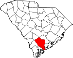
Colleton County, South Carolina Basics:


Colleton County South Carolina - Government Site

Population: 38,211
Area: 1056 square miles
County seat: Walterboro
Area code(s) in use: 843
Time zone: EST
High school graduate or higher: 76.7%
Bachelor's degree or higher: 13.7%
Median household income: $31,289
Persons in poverty: 21.6%
Home ownership rate: 74.1%
Mean travel time to work: 33.0 minutes


Adjacent counties:
Allendale  Bamberg  Beaufort  Charleston  Dorchester  Hampton  Orangeburg  

Find in South Carolina

Map of the Colleton County area


Our detail map of Colleton County shows the Colleton County, South Carolina boundary lines and other interesting items.

Places in Colleton County, South Carolina

  Airports     show all on map

Airy Hall Airport, Broxton Bridge Plantation Airport, Hannah Rhea Field Airport, Lowcountry Regional Airport

  Bars     show all on map

Combahee Bank

  Basins     show all on map

Parkers Bay

  Beaches     show all on map

Edisto Beach

  Bends     show all on map

Hole-in-the-Wall

  Bridges     show all on map

Broxton Bridge, Fishpond Bridge, Horseshoe Bridge, Ivanhoe Bridge, Price Bridge, Raysor Bridge, Saltketcher Bridge, Stokes Bridge

  Buildings     show all on map

Canadys Steam Electric Generating Plant, Colleton County Courthouse, Colleton County Emergency Preparedness Agency, Colleton County Fire - Rescue Adnah Church, Colleton County Fire - Rescue Ashton, Colleton County Fire - Rescue Bells, Colleton County Fire - Rescue Bennett's Point, Colleton County Fire - Rescue Bonnie Doon, Colleton County Fire - Rescue Canadys, Colleton County Fire - Rescue Canadys Substation, Colleton County Fire - Rescue Cane Branch, Colleton County Fire - Rescue Cottageville, Colleton County Fire - Rescue Edisto Beach, Colleton County Fire - Rescue Edisto Island, Colleton County Fire - Rescue Foxfield, Colleton County Fire - Rescue Green Pond, Colleton County Fire - Rescue Headquarters, Colleton County Fire - Rescue Hendersonville, Colleton County Fire - Rescue Industrial Park, Colleton County Fire - Rescue Intercommunity, Colleton County Fire - Rescue Islandton, Colleton County Fire - Rescue Jacksonboro, Colleton County Fire - Rescue Lodge, Colleton County Fire - Rescue Maple Cane, Colleton County Fire - Rescue Mt Carmel, Colleton County Fire - Rescue Neyles, Colleton County Fire - Rescue Ritter, Colleton County Fire - Rescue Ruffin, Colleton County Fire - Rescue Smoaks, Colleton County Fire - Rescue Station 1 South Waterboro, Colleton County Fire - Rescue Station 27, Colleton County Fire - Rescue Station 31 Breland Hill, Colleton County Fire - Rescue Venice Point, Colleton County Fire - Rescue White Hall, Colleton County Fire - Rescue Williams, Colleton County Fire / Rescue Green Pond Rural, Colleton County Memorial Library, Colleton County Sheriff's Office, Colleton Museum, Colleton Place, Cottageville Fire Department, Cottageville Police Department, Edisto Beach Police Department, Slave Relic Museum, South Carolina Highway Patrol Troop 6 Post B, University of South Carolina Salkehatchie East Library Building, Walterboro Fire Department, Walterboro Fire Department Substation, Walterboro Police Department

  Canals     show all on map

Matthews Canal

  Capes     show all on map

Bennetts Point, Fields Point

  Cemeteries     show all on map

Ackerman Cemetery, Adams Cemetery, Adnah Cemetery, Ashton Cemetery, Bethel Cemetery, Breland Cemetery, Bridge Cemetery, Buckhead Cemetery, Buzzard Roost Cemetery, Canadys Cemetery, Carter Ford Cemetery, Church Hill Cemetery, Colonel Joseph Risher Cemetery, Community Cemetery, Connor Cemetery, Cross Swamp Cemetery, Doctors Creek Cemetery, Evergreen Cemetery, Ferguson Cemetery, Grace Cemetery, Green Pond Cemetery, Gruber Cemetery, Hagan Cemetery, Haynes Cemetery, Hiott Cemetery, Hughes Cemetery, Isaac Hayne Tomb, John Herndon Cemetery, Jones Cemetery, Liveoak Cemetery, Lodge Cemetery, May Cemetery, May-Stokes-Raysor Cemetery, Mount Carmel Cemetery, Old Field Creek Cemetery, Old Miss Cemetery, Patrick Cemetery, Peniel Cemetery, Pine Grove Cemetery, Providence Cemetery, Rice Path Cemetery, Rizer Cemetery, Round O Cemetery, Ruffin Cemetery, Sanders Cemetery, Shiloh Cemetery, Smith Cemetery, Smith Cemetery, Smoaks Cemetery, Smyly Cemetery, Spell Cemetery, Spell-Risher Cemetery, Strickland Cemetery, Tabernacle Cemetery, Tabor Cemetery, Trinity Cemetery, Ulmer Cemetery, Warren-Key Cemetery, Wesley Cemetery, White Meeting Cemetery, Williams Cemetery, Williams Cemetery, Zion Cemetery

  Census     show all on map

Islandton Census Designated Place, Jacksonboro Census Designated Place

  Channels     show all on map

Ashepoo Coosaw Cutoff, Bull Cut, Fenwick Cut, Otter Creek

  Churches     show all on map

Abraham Church, Adnah Church, Aimwell Church, Airy Hall Church (historical), Ashton Church, Bachelor Hill Church, Bedons Baptist Church, Berea Advent Church, Bethany Church, Bethel Church, Bethel Church, Bethel Church, Bethel Church, Bethel Presbyterian Church, Bethel United Methodist Church, Bethel United Methodist Church, Bethlehem Church, Beulah Church, Black Creek Church, Bosom Bottom Church, Buckhead Church, Calvary Church, Calvary Church, Canaan Church, Canaan Church, Cannan Church, Carter Ford Church, Catholic Hill Church, Church of God, Church of God and Prophecy, Combahee Church (historical), Community Church, Cottageville Baptist Church, Cottageville Church, Cross Swamp Church, Cumberland Church, Cypress Pond Church, Deep Creek Church, Doctors Creek Church, Ebenezer Church, Ebenezer Church, Ebenezer Church, Edgewood Baptist Church, Edisto Church, Evergreen Church, First Baptist Church, First Christian Church, Friendship Church, God of Prophesy Church, Good Shepherd Lutheran Church, Grace Church, Great Swamp Church, Greater Saint James Holiness Church, Green Pond Church, Green Pond Church, Hendersonville Baptist Church, Heyward Church, Hickory Hill Church, Holiness Tabernacle Church, Hunters Chapel, Indian Creek Church, Isaiah Church, Jacksonboro Church, Jericho Church, Jones Swamp Holiness Church, Joshua Church, Little Rock Church, Lodge Methodist Church, Lovely Hill Church, Macedonia Church, Manuel Church, Maple Cane Church, Marys Church, McCuren Branch Church, Mount Carmel Church, Mount Nebo Church, Mount Nebo Church, Mount Nevo Church, Mount Olive Church, Mount Olive Church, Mount Pleasant Church, Mount Sina Church, New Hope Church, New Hope Church (historical), Oak Grove Church, Oak Grove Church, Oakman Church, Pemel Church, Peniel Baptist Church, Peniel Church, Peoples Church, Pine Grove Number 1 Baptist Church, Piney Grove Church, Piney Grove Church, Pleasant Grove Church, Providence Church, Red Bank Church, Red Oak Church, Rehoboth Church, Rice Patch Christian Church, Ruffin Baptist Church, Ruffin Church, Saint Johns Church, Saint Judes Episcopal Church, Saint Marks Church, Saint Marys Church, Saint Pauls Church, Saint Peters Church, Salem Church (historical), Samaritan Church, Sand Hill Baptist Church, Sandy Dam Church, Shiloh Church, Smoaks Baptist Church, Springhill Church, Springtown Church, Sykes Savannah Church, Tabernacle Church, Tabor Methodist Church, The Church of Jesus Christ of Latter Day Saints, Tobys Bluff Church, Trinity Church, Trinity Church, Trinity Methodist Church, Wesley Chapel, Wesley Church, Wesley United Methodist Church, White Hall Church, Zion Baptist Church, Zion Church, Zion Church, Zion Church

  Cliffs     show all on map

Toby Bluff

  Crossings     show all on map

Ashepoo Ferry (historical), Combahee Ferry (historical), Interchange 42, Interchange 53, Interchange 57, Interchange 62, Interchange 68, Millers Ford, Parkers Ferry (historical)

  Dams     show all on map

Ashepoo Plantation Pond Dam D-2387, Bennetts Pond Dam D-0643, Big Survey Lake Dam D-2547, Cokers Pond Dam D-0649, Crosbys Pond Dam D-2546, Fishbourne Reservoir D-2386 Dam, South Carolina Noname 15007 D-2384 Dam, South Carolina Noname 15008 D-2385 Dam, South Carolina Noname 15028 D-2383 Dam, South Carolina Noname 15033 D-2388 Dam, Westglow Haven Lake Dam D-2389

  Hospitals     show all on map

Colleton Ambulatory Surgery Center, Colleton Medical Center

  Islands     show all on map

Ashe Island, Bay Island, Bear Island, Beet Island, Big Island, Bluff Islands, Bowles Island, Cattle Island, Fenwick Island, Gunboat Island, Hutchinson Island, Minkey Island, Musselboro Island, Oakhurst Island, Otter Islands, Pine Island, Pine Island, Prospect Hill Island, Sampson Island, Sawyers Island, Settlement Islands, Tilly Island, Warren Island

  Lakes     show all on map

Bryans Lake, Green Pond, Hickory Hill Lake, Jones Lake, Parker Hole

  Locales     show all on map

Airy Hall, Airy Hall Plantation, Blake Siding, Bluefield Hunting Club, Camp Buddy, Cherokee Plantation, Coe Plantation, Colleton Square Shopping Center, Combahee Plantation, Dodge Plantation, Dogwood Hills Country Club, Fishburne Plantation, H and B Junction, Hope Plantation, Ivanhoe Shopping Center, Laurel Springs Plantation, Lavington Plantation, Longbrow Plantation, Maybank Plantation, Myrtle Grove Plantation, Pendergrass Cross Roads, Poco Sabo Plantation, Rose Hill Plantation, Smokes Corners, Walterboro Plaza Shopping Center, Walterboro Wastewater Treatment Facility, Walters Store, White Hall Plantation, Whitehouse Plantation

  Military     show all on map

Walterboro Army Air Field (historical)

  Parks     show all on map

Bear Island Game Management Area, Colleton State Park, Givhans Ferry State Park, Hickory Valley Historic District, Walterboro Historic District

  Populated Places     show all on map

Ashepoo, Ashepoo Crossing, Ashepoo Siding, Ashton, Beck Landing, Bells Crossroads, Bennetts Point, Blake, Bluehouse Corners, Burnt Church Crossroads, Burr Hill, Caldwell, Canadys, Catholic Hill, Colleton, Combahee (historical), Cottageville, Davis Hill, Drawdy, Drigger Crossroads, Edisto Beach, Fenwick, Gloverville, Goodhope Landing, Green Pond, Hendersonville, Hickory Hill, Hiotts, Holly Ridge, Hudsons Mill, Iron Crossroads, Islandton, Jacksonboro, Johnsville, Jonesville, Kelsey Cove Landing, Lodge, Long Creek Landing, Lowndes Landing, Mas Old Field Landing, Metz Store (historical), Moselle, Neyles, Padgett Landing, Padgetts, Parkers Ferry Landing, Pattillo (historical), Pine Hill Landing, Prices Landing, Pringle Bend, Red Bank (historical), Red Oak Corner, Rhodes Crossroads, Ritter, Round O, Ruffin, Salkehatchie, Seabrook, Sidney, Smoaks, Smyly, Sniders Crossroads, Springtown, Stokes, Thayer, Tobys Bluff, Varntown (historical), Walterboro, Weeks, White Hall, Wiggins, Williams

  Post Offices     show all on map

Canadys Post Office, Cottageville Post Office, Green Pond Post Office, Islandton Post Office, Jacksonboro Post Office, Lodge Post Office, Round O Post Office, Ruffin Post Office, Smoaks Post Office, Walterboro Post Office, Williams Post Office

  Reservoirs     show all on map

Bennetts Pond, Big Survey Lake, Cokers Pond, Crosbys Pond, Fenders Mill Pond (historical), Hudson Mill Pond (historical), J J Padgett Pond, Lake Lucious, Reservoir Pond, Westglow Haven Lake

  Schools     show all on map

Ashton School (historical), Bedons School (historical), Bells Elementary School, Bennetts Point School, Benton Mill School (historical), Benton's Mill School, Bertha School (historical), Bethel School, Bethel School, Bethel School (historical), Bethlehem School, Bethlehem School (historical), Big Gate School (historical), Black Street Elementary School, Blue House School (historical), Burr Hill School (historical), Cane Branch School (historical), Caney Branch School, Catholic Hill School (historical), Cavern Branch School, Cedar Branch School, Cedar Grove School (historical), Cherokee School (historical), Colleton Annex Learning Center, Colleton County Education Center, Colleton County High School, Colleton Elementary School, Colleton Middle School, Cottageville Elementary School, Cross Swamp School, Deep Creek School (historical), Dryer School, Ebenezer School, Edisto Beach Elementary School, Edisto School, Elbow School (historical), Fields Point School (historical), Fire Hill School, First Baptist Kindergarten, Folk School, Forest Circle Middle School, Forest Hills Elementary School, Friendship School, Fuller School, Gloverville School (historical), Hall School, Hampton Street Elementary School (historical), Hendersonville Elementary School, Hendersonville School (historical), Heyward School (historical), Heyward School (historical), Hickory Hill School (historical), Hudson Mill School (historical), Irons Cross Roads School (historical), Islandton School (historical), Ivenia Brown Elementary School (historical), Jacksonboro School (historical), Jericho School (historical), Jonesville Elementary School, Koger School, Linder School, Little Rock School, Little Rock School (historical), Maple Cane School, Mashawville School, Mission School (historical), Mount Carmel School, Mount Carmel School (historical), Mount Pleasant School (historical), New Hope School, Newville School, Neyles School (historical), Neyles School (historical), Northside Elementary School, Oak Grove School, Oak Grove School, Oak Grove School (historical), Oakgrove School (historical), Oakman Branch School (historical), Old Bethel School (historical), Omega School, Pemel School, Peniel School (historical), Peoples School, Pine Hill School (historical), Piney Grove School, Piney Grove School, Pleasant Grove School (historical), Polly Bottom School, Providence School, Red Root School (historical), Redbank School, Redoak School (historical), Rehoboth School (historical), Rehoboth School (historical), Ricepatch School (historical), Ritter School (historical), Roadside School, Roadside School (historical), Roadside School (historical), Ruffin High School, Ruffin Middle School, Rum Gully School, Rum Gully School (historical), Saint Peters School (historical), Sandhill School (historical), Seabrook School (historical), Sheridan School (historical), Simmons Johnsville School (historical), Skull Branch School, Smoaks Middle School, Sniders School (historical), Snipe School, Snipe School (historical), Springtown School, Stokes School (historical), Stone Branch School (historical), Strickland School, Tabor School, Tabor School (historical), Thunderbolt Career and Technology Center, Tobys Bluff School (historical), Trinity School (historical), University of South Carolina Salkehatchie - Walterboro Campus, University of South Carolina Salkehatchie East Gymnasium, University of South Carolina Salkehatchie East Liberal Arts Building, University of South Carolina Salkehatchie East Main Building, University of South Carolina Salkehatchie East Science Building, Wards Cross School (historical), Welch Green School (historical), Wesley School (historical), White Hall School (historical), Wiggins School (historical), Wolf Creek School (historical), Zion School (historical)

  Streams     show all on map

Allen Creek, Alligator Creek, Ashe Creek, Ashepoo River, Ashton Branch, Bank Creek, Baptist Church Branch, Bear Branch, Black Creek, Boston Branch, Brickhouse Branch, Buckhead Creek, Bull Creek, Cedar Branch, Chehaw River, Chessey Creek, Cold Water Branch, Combahee River, Coosaw River, Craven Branch, Crooked Creek, Cuckolds Creek, Deep Bottom Creek, Deep Creek, Deep Creek, Deer Creek, Doctors Creek, Dry Branch, Fender Creek, Fish Creek, Folly Creek, Fuller Swamp Creek, Hog Branch, Hope Creek, Horse Pen Branch, Horseshoe Creek, Horseshoe Lead Creek, Indian Creek, Ireland Creek, Jefford Creek, Johno Creek, Jones Swamp Creek, Little Salkehatchie River, Long Ashepoo Creek, Long Branch, McCuren Branch, Mosquito Creek, Musselboro Creek, New Chehaw River, Old Chehaw River, Oldfield Creek, Perry Creek, Pine Island Creek, Pringle Creek, Redbank Drain, Reevestown Branch, Ricepatch Creek, Rock Creek, Rum Gully, Sampson Island Creek, Sandy Dam Branch, Sandy Run, Sandy Run, Savannah Creek, Shereau Branch, Skull Branch, Social Hall Creek, South Edisto River, Steedley Branch, Two Sisters Creek, Willow Swamp, Wolf Creek

  Swamps     show all on map

Allen Meadow, Big Bay, Big Bay Swamp, Big Swamp (historical), Bluehouse Swamp, Burden Swamp, Calfpen Swamp, Cross Swamp, Deep Bottom Bay, Elliot Swamp (historical), Fosters Bay, Great Swamp, Green Meadow, Henry James Swamp (historical), Horse Bay, Jenkins Swamp (historical), Jones Creek, Logging Savanna, Maple Cane Swamp, Moselle Swamp, Oats Hole, Remick Swamp, Saint Johns Swamp (historical), Snuggedy Swamp, Tupelo Swamp, Warrens Savanna

  Towers     show all on map

Cane Branch Lookout Tower, Cottageville Lookout Tower, Lodge Lookout Tower, Stokes Lookout Tower, WALD-FM (Walterboro), WJWJ-FM (Beaufort), WJWJ-TV (Beaufort), WPOG-AM (Walterboro)

  Woods     show all on map

White House Woods,

Colleton County, South Carolina Population By Race (2012 estimate)

RacePopulation
WhiteColleton County White population 22,31522,315  
BlackColleton County Black population 14,86414,864
MixedColleton County Mixed population 535534
American IndianColleton County American Indian population 306305
AsianColleton County Asian population 191191
Hawaiian & Pacific IslanderColleton County Hawaiian & Pacific Islander population 00

Additional population tables :
State population table
South Carolina population by county