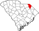
Marlboro County, South Carolina Basics:


Marlboro County South Carolina - Government Site

Population: 28,141
Area: 480 square miles
County seat: Bennettsville
Area code(s) in use: 843
Time zone: EST
High school graduate or higher: 70.3%
Bachelor's degree or higher: 9.8%
Median household income: $28,612
Persons in poverty: 29.2%
Home ownership rate: 64.5%
Mean travel time to work: 21.7 minutes


Adjacent counties:
Anson (NC)  Chesterfield  Darlington  Dillon  Florence  Richmond (NC)  Robeson (NC)  Scotland (NC)  

Find in South Carolina

Map of the Marlboro County area


Our detail map of Marlboro County shows the Marlboro County, South Carolina boundary lines and other interesting items.

Places in Marlboro County, South Carolina

  Airports     show all on map

Clio Crop Care Airport, Mack Lamar Airport, Marlboro County Jetport - HE Avent Field

  Basins     show all on map

McLaurin Bay, Newton Bay, Sandhill Bay

  Bridges     show all on map

Cheraw Bridge (historical)

  Buildings     show all on map

Bennettsville City Hall, Bennettsville Fire Department Downtown, Bennettsville Fire Department Northside, Bennettsville Police Department, Blenheim Fire Department Blenheim, Blenheim Fire Department Brownsville, Blenheim Fire Department Drake, Blenheim Fire Department Monroe Crossroad, Blenheim Fire Department Stoneaway, Brightsville Fire Department, Clio City Hall, Clio Police Department, Clio Rescue Squad, Clio Rural Fire Department Clio, Clio Rural Fire Department Eastside, Evans Correctional Institution, Federal Correctional Institution Bennettsville, Marlboro County Courthouse, Marlboro County Public Library, Marlboro County Rescue Squad, McColl Fire Department, Wallace Fire Department Hair Town, Wallace Fire Department Smithville, Wallace Fire Department Wallace, Wallace Rescue Squad

  Capes     show all on map

Welsh Neck

  Cemeteries     show all on map

Beauty Spot Cemetery, Beaverdam Cemetery, Brigman Cemetery, Brownsville Cemetery, Colonel Kolbs Tomb, Ebenezer Cemetery, Ebenezer Cemetery, English Cemetery, Evergreen Cemetery, Hebron Cemetery, Hubbard Cemetery, Ideal Cemetery, Level Green Cemetery, Lucas Cemetery, McCall Cemetery, McLaurin Cemetery, McQuage Cemetery, Newton Cemetery, Oak Ridge Cemetery, Parnassus Graveyard, Peele Cemetery, Pleasant Hill Methodist Church Cemetery, Quick Cemetery, Quick Cemetery, Quick Cemetery, Sunset Memorial Park, White Creek Free Will Baptist Cemetery, White Oak Cemetery

  Census     show all on map

Pee Dee State Designated Tribal Statistical Area, Wallace Census Designated Place

  Churches     show all on map

Aaron Temple Methodist Church, Annarate Church (historical), Antioch Church, Antioch Church, Asbury Church, Beaverdam Church, Berea Church, Bethel Church, Bethel Church, Bethlehem Church, Beulah Church (historical), Beulah Church (historical), Beulah Methodist Church, Boykin Church, Boykin Church (historical), Breedens Chapel (historical), Bristow Freewill Church, Brownsville Church, Brownsville Church (historical), Brutons Fork Church, Calvary Church, Cedar Falls Church, Church of God, Community Chapel, Driggers Chapel, Dunbar Presbyterian Church (historical), Dyers Hill Church, Eastside Baptist Church, Ebenezer Church, Ebenezer Church, Ebenezer Church, Emmanuel Church, Evans Church, Fairplain Church, First Baptist Church, First Baptist Church, First Church of the Nazarene, First Presbyterian Church, First Presbyterian Church, First United Methodist Church, Fletcher Grove Church, Fletchers Chapel, Free Will Church, Friendship Church, Galilee Church, Goodwins Chapel, Hebron Church, Hickory Grove Church, Holiness Church, Holiness Tabernacle (historical), Hopewell Church, Level Green Church, Macedonia Missionary Church, Main Street Methodist Church, McCall Church, McColl Church of God, Mount Elohim Church, Mount Tabor Church, Mount Zion Church, New Hill Church, New Hope Church, Oak Grove Church, Oak Grove Church, Oak Grove Church, Old Clio Church, Old Gailee Church, Old Smyrna Church, Parnassus Church, Pee Dee Church, Pine Grove Church, Piney Plain Church, Pleasant Hill Church, Pleasant Hill Church, Prevatts Chapel, Red Bluff Presbyterian Church (historical), Reedy Branch Church, Reedy Branch Church (historical), Saint Denis Church, Saint James Church, Saint Lukes Church, Saint Marks Church, Saint Matthews Church, Saint Michael Methodist Church, Saint Pauls Church, Saint Pauls Church, Saint Pauls Church, Salem Church, Sandy Grove Church, Sardis Church, Sarion Church, Sawmill Church, Shiloh Church, Shiloh Church, Shiloh Church, Spears Church, Symrna Church, Thomas Memorial Church, Trinity Church, Victory Temple, Wallace Church, Washington Temple, Wesley Church, Wesley Church (historical), Wesleyan Church, White Creek Church, Whites Creek Church, Zion Church, Zion Church

  Cliffs     show all on map

Gardners Bluff, Hunts Bluff

  Crossings     show all on map

Parkers Ferry (historical), Sparks Ferry (historical)

  Dams     show all on map

Adams Pond Dam D-3439, Ballard Pond Dam D-3442, Becker Pond Dam D-3449, Bel Acres Pond Dam D-3451, Camp Pee Dee Pond Number One Dam D-3434, Camp Pee Dee Pond Number Two Dam D-3435, Camp Sandy Ridge Pond Dam D-3433, Canal Industries Pond Dam D-2950, Carraway Pond Dam D-3447, Curtis Pond Dam D-3436, Delta Pond Dam D-3462, Grants Mill Pond Dam D-3429, Grey Pond Dam D-3460, Haire Pond Dam D-3431, Honeysucker Pond Dam D-2959, McCall Pond Dam D-3448, McInnis Pond Dam D-3434, McMeekin Pond Dam D-3430, Pusser Pond Dam D-3425, Quick Pond Dam D-3437, Rivers Pond Dam D-3438, Rollins Pond Dam D-2945, South Carolina Noname 35001 D-3426 Dam, South Carolina Noname 35002 Dam, South Carolina Noname 35003 D-3411 Dam, South Carolina Noname 35004 D-3450 Dam, South Carolina Noname 35006 Dam, South Carolina Noname 35007 D-3459 Dam, South Carolina Noname 35008 Dam, South Carolina Noname 35009 D-3444 Dam, South Carolina Noname 35011 D-3446 Dam, South Carolina Noname 35012 D-3455 Dam, South Carolina Noname 35013 D-3453 Dam, South Carolina Noname 35015 Dam D-3427, South Carolina Noname 35016 D-3455 Dam, South Carolina Noname 35017 D-3428 Dam, South Carolina Noname 35020 D-3432 Dam, South Carolina Noname 35024 D-2946 Dam, South Carolina Noname 35025 D-3452 Dam, South Carolina Noname 35029 D-3456 Dam, South Carolina Noname 35030 D-3458 Dam, South Carolina Noname 35034 D-2947 Dam, South Carolina Noname 35036 D-3443 Dam, South Carolina Noname 35039 D-3461 Dam, South Carolina Noname 35040 D-2944 Dam, South Carolina Noname 35041 D-2949 Dam

  Guts     show all on map

Lake Creek, Machine Branch, Riggins Branch

  Hospitals     show all on map

Evans Correctional Institution Infirmary, Marlboro County General Hospital, Marlboro Park Hospital

  Islands     show all on map

Stag Rock

  Lakes     show all on map

Goodwins Millpond, Henegan Lake, Mathesons Millpond, McCalls Millpond, McLaurins Millpond, Rogers Lake, The Little Lakes

  Locales     show all on map

Aarons Temple, Bi-Lo Shopping Center, Bullards Mill (historical), Camp Pee Dee, Covington Mill (historical), Davids Mill (historical), Goodwins Mill (historical), Grants Mill (historical), Mathesons Mill (historical), McCalls Mill (historical), McLaurins Mill (historical), McLaurins Mill (historical), McNairs Mill (historical), Moores Mill (historical), Pine Hill Baptist Retreat, Quicks Mill (historical), Sawyers Mill (historical), Smiths Mill (historical)

  Parks     show all on map

Bennettsville Historic District, Clio Historic District

  Populated Places     show all on map

Adamsville Crossroads, Argyle, Ayers (historical), Beauty Spot (historical), Bennettsville, Blenheim, Boykin, Breeden, Bristow, Brownsville, Brutons Fork, Burnt Factory (historical), Century Acres, Chavistown, Clio, Country Club Heights, Drake, Dunbar, Dundee Acres, Dyers Hill, Everetts (historical), Five Forks, Fletcher, Fulton, Genoa, Grace Heights, Hebron, Hickson (historical), Irby (historical), Islay (historical), Lake Terrace, Lakeside, Lester, Little Mountain (historical), Madeline, Marlboro, McColl, McDonalds, McInnis (historical), Monroe Crossroads, Newtonville, Parnassus, Quick Crossroads, Red Bluff, Reedy Creek Springs (historical), Salem, Scott, Sunnybrook Heights, Tatum, Wallace, Welsh Neck (historical)

  Post Offices     show all on map

Bennettsville Post Office, Clio Post Office, McColl Post Office

  Reservoirs     show all on map

Adams Pond, Anderson Millpond, Andersons Millpond, Becker Pond, Bennett Pond, Bullards Millpond, Burnt Factory Pond, Camp Pee Dee Pond Number One, Camp Pee Dee Pond Number Two, Camp Sandy Ridge Pond, Canal Industries Pond Dam, Carraway Pond, Couingtons Millpond, Covington Millpond, Curtis Pond, Dailys Pond, Davids Millpond, Davids Millpond, Doctor Mays Pond, Drakes Millpond, Drakes Pond, Everette Mill Pond, Gillespies Pond (historical), Girl Scout Pond, Grants Mill Pond, Grants Millpond, Grey Pond, Haire Pond, Honeysucker Pond, Hugh Driggers Pond, J E Powe Pond, J P Stevens Pond, L E Pence Pond, Lake Wallace, Lake Wallace, Mabry Searcy Pond, Marvin Adams Pond, McCalls Millpond, McLaurins Millpond, McMeekin Pond, McNairs Millpond, Moore Pond, NcNairs Millpond, Paul Wallace Pond, Poston Pond, Pusser Pond, Quick Pond, Red Bluff Lake, Red Bluff Pond, Rivers Pond, Rollins Pond, Smith Pond, Usher Pond, Wallace Pond

  Ridges     show all on map

Ballast Ridge

  Schools     show all on map

Adamsville School, Beaver Dam School (historical), Bennettsville Middle School, Bennettsville Primary School, Berea School (historical), Blenheim Elementary School, Blenheim Middle School, Blenheim School, Boykin School (historical), Brightsville School (historical), Brightville School (historical), Brownsville School (historical), Brownsville School (historical), Clio Elementary School, Clio Middle School, Coulter Mission School (historical), Cross Roads School (historical), Cross Roads School (historical), Dargan School (historical), Drake School (historical), Dry Branch School (historical), Dudley School (historical), Dunbar School (historical), Dyers Hill School, Eastside Junior High School, Ebenezer School (historical), Ebenezer School (historical), Fletcher Grove School (historical), Fletcher Memorial School, Harmony School (historical), Hebron Academy (historical), Hebron School (historical), Hopewell School (historical), Hunts Bluff School (historical), Hunts Bluff School (historical), Irby School (historical), Key School (historical), Key School (historical), Kollocks School, Lester School (historical), Level Green School (historical), Lincoln School (historical), Macedonia School (historical), Marlboro Academy, Marlboro County Industrial and High School (historical), Marlboro School, McCall School (historical), McColl Elementary School, McColl Middle School, McColl-Fletcher Memorial High School, Murchison School (historical), New Galilee School (historical), New Hope School (historical), Oak Grove School (historical), Oak Ridge School, Palmetto Creek School (historical), Parnassus School (historical), Pegues School (historical), Pineville School, Pineville School, Reedy Branch School (historical), Roper Grove School (historical), Saint Marks School (historical), Saint Paul School (historical), Salem School (historical), Sandhill School (historical), Smiths School (historical), Wallace Elementary School, Wallace Middle School, Wesley School (historical), White Creek School (historical), Willis School (historical), Wilson School (historical)

  Streams     show all on map

Bear Creek, Beaverdam Creek, Beaverdam Creek, Beverly Creek, Big Branch, Brownsville Creek, Carters Branch, Cottingham Creek, Crooked Creek, Gulley Branch, Gum Swamp Creek, Hagins Prong, Herndon Branch, Hicks Creek, Husbands Creek, Lightwood Knot Creek, Lilly Quick Creek, Marks Creek, Marsnip Branch, Monroe Branch, Muddy Creek, Naked Creek, Panther Creek, Parker Branch, Phils Creek, Reedy Branch, Rogers Creek, Tarkiln Creek, Three Creeks, White Oak Branch, Whites Creek, Wolf Creek

  Summits     show all on map

Beattie Hill

  Swamps     show all on map

Burnt Bay, Goose Marsh, Hilson Bay, Juniper Bay, Mossy Bay, Sandy Ocean

  Towers     show all on map

Ballast Ridge Lookout Tower, Bennettsville Lookout Tower, Blenheim Lookout Tower, WBSC-AM (Bennettsville),

Marlboro County, South Carolina Population By Race (2012 estimate)

RacePopulation
BlackMarlboro County Black population 14,35214,351  
WhiteMarlboro County White population 11,90411,903
American IndianMarlboro County American Indian population 1,2941,294
MixedMarlboro County Mixed population 478478
AsianMarlboro County Asian population 113112
Hawaiian & Pacific IslanderMarlboro County Hawaiian & Pacific Islander population 00

Additional population tables :
State population table
South Carolina population by county