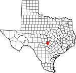
Blanco County, Texas Basics:
Blanco County Texas - Government Site
Population: 10,673
Area: 709 square miles
County seat: Johnson City
Area code(s) in use: 830
Time zone: CST
High school graduate or higher: 88.6%
Bachelor's degree or higher: 27.7%
Median household income: $46,881
Persons in poverty: 9.3%
Home ownership rate: 79.8%
Mean travel time to work: 26.2 minutes
Adjacent counties:
Burnet Comal Gillespie Hays Kendall Llano Travis
Places in Blanco County, Texas
Bamberger Ranch Airport,
Blanco Landing Airport,
Byram Ranch Airport,
Charlie Thomas Ranch Airport,
Cross Triangle Ranch Airport,
Danz Ranch Airport,
Fall Creek Air Ranch Airport,
Harris Ranch Airport,
Keller Ranch Airport,
Kennedy Ranch Airport,
Moursund Ranch Airport,
Pippen-York Ranch Airport,
Rocky Top Ranch Airport,
Tatum Ranch Airport,
West Ranch Airport Adrian Edwards Conn House,
Blanco County Jail, Blanco Library,
Blanco Volunteer Ambulance,
Blanco Volunteer Fire Department,
Happy Old Folks Home, Johnson City Library,
Johnson City Volunteer Fire Department,
North Blanco County Emergency Medical Services,
Round Mountain Stage-Coach Inn and Stable,
Round Mountain Volunteer Fire Department Blanco Cemetery,
Comanche Cemetery,
Davis Cemetery,
Henly Cemetery,
Jonas Cemetery,
McKinney Cemetery,
Miller Creek Cemetery,
Payton Cemetery,
Round Mountain Cemetery,
Sandy Cemetery,
Twin Sisters Cemetery,
Wegner Cemetery Mount Horebe Church,
Rocky Community Church,
Saint Mary Church,
Walnut Hill Church Red Bluff Blanco City Dam Number 1,
Lake Johnson City Dam,
Soil Conservation Service Site 1 Dam,
Tatum Lake Dam,
Wayne Smith Dam Pedernales Falls Rattlesnake Flat Casner Gap,
Naumans Gap,
Porter Gap,
Stubbins Gap Mustang Lake,
Taylor Lake Blanco Historic District,
Circle Bar Ranch,
Dead Mans Ford,
Deike Ranch,
Harvey Ranch,
Hereford Hills Ranch,
Kilborn Ranch,
Peese Ranch,
Robinson Community Hall,
Rocky Creek Ranch,
Voyles Lazy V Ranch,
WE Four Ranch,
West Ranch Blanco State Park,
Blanco State Park,
Pedernales Falls State Park Blanco,
Blowout, Boon, Colony (historical),
Cypress Mill,
Flugrath,
Hye,
Johnson City,
Payton,
Post Oak,
Rocky Creek,
Round Mountain,
Sandy,
Twin Sisters,
Westbrook (historical) Blanco Post Office,
Hye Post Office,
Johnson City Post Office, Westbrook Post Office (historical)
Blanco City Lake Number 1,
Lake Johnson City,
Soil Conservation Service Site 1 Reservoir,
Tatum Lake,
Wayne Smith Lake Middle Ridge Blanco Elementary School, Blanco High School, Blanco Middle School, Lyndon B Johnson Elementary School, Lyndon B Johnson High School, Lyndon B Johnson Middle School,
Payton School,
Pleasant Hill School,
Rocky School Beckman Springs,
Boardhouse Spring,
Boardhouse Springs,
Buffalo Springs, Cold Spring,
Comanche Spring,
Crofts Springs, Cypress Mill Springs (historical),
Duncan Spring, Epps Springs,
Hobbs Spring, Honeycut Springs, Jones Springs,
Koch Springs, Lewis Springs, Pedernales Springs,
Rocky Creek Springs, Salter Springs, Sharp Springs,
Sultemeier Springs, Three Springs, Uecker Springs,
Walnut Spring Bates Creek,
Big Branch,
Blasingame Creek,
Boardhouse Creek,
Buffalo Creek,
Calohan Creek,
Cedar Creek,
Cleveland Branch,
Cottonwood Creek,
Cottonwood Creek,
Cove Branch,
Crabapple Creek,
Cypress Branch,
Deer Creek,
Durham Branch,
East Fork Hinds Branch,
East Fork Rocky Creek,
East Prong Big Creek,
Falls Creek,
Flat Creek,
Flat Creek,
Flat Creek,
Hagerman Branch,
Hardin Russell Creek,
Hickory Creek,
Hinds Branch,
Iron Rock Creek,
Kentucky Branch,
Koch Branch,
McCall Creek,
McKinney Creek,
Middle Creek,
Middle Creek,
Middle Fork Rocky Creek,
Miller Creek,
Millseat Branch,
North Cypress Creek,
North Grape Creek,
Pecan Creek,
Post Oak Creek,
Rochou Creek,
Rocky Creek,
Rocky Creek,
Rogers Branch,
Salter Spring Creek,
Schuetz Creek,
Smith Spring Branch,
Spring Creek,
Stribling Creek,
Sycamore Creek,
Tank Water Creek,
Towhead Creek,
Town Creek,
Turkey Creek,
Walker Branch,
Wallace Branch,
Walnut Creek,
West Fork Hinds Branch,
West Fork Rocky Creek,
White Oak Creek,
Williams Creek,
Yeager Creek,
Zigzag Creek Big Mountain,
Brushy Top,
Buffalo Peak,
Cave Mountain,
Cedar Mountain,
Coon Mountain,
Howell Mountain,
Indian Head,
Indian Peak,
Long Mountain,
Martin Mountain,
Monument Hill,
Pond Mountain,
Rattlesnake Mountain,
Round Mountain,
Shovel Mountain,
Tabletop Mountain,
Tater Hill,
Twin Sisters KLNO-TV (Llano) Blanco State Park Trail,
Falls Trail,
Fou Mile Loop,
Pedernales Falls State Park Equestrian Trails,
Wolf Mountain Trail Anderson Hollow,
Brock Hollow,
Brock Hollow,
Greens Hollow,
Pond Hollow,
Potts Hollow,
Rough Hollow,
Russell Hollow,
The Cove,

