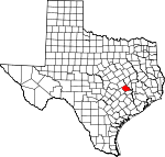
Burleson County, Texas Basics:
Burleson County Texas - Government Site
Population: 17,316
Area: 659 square miles
County seat: Caldwell
Area code(s) in use: 979
Time zone: CST
High school graduate or higher: 75.8%
Bachelor's degree or higher: 11.4%
Median household income: $43,976
Persons in poverty: 14.4%
Home ownership rate: 79.8%
Mean travel time to work: 28.4 minutes
Adjacent counties:
Brazos Lee Milam Robertson Washington
Places in Burleson County, Texas
Burleson County Hospital Heliport,
Caldwell Municipal Airport,
Weber Ranch Airport Beaver Creek Volunteer Fire Department,
Birch Creek Area Volunteer Fire Department,
Blackjack Volunteer Fire Department,
Burleson County Constable's Office Precinct 2,
Burleson County Constable's Office Precinct 3,
Burleson County Czech Heritage Museum,
Burleson County Historical Museum,
Burleson County Jail,
Caldwell Police Department,
Caldwell Volunteer Fire and Rescue Department,
Cooks Point Volunteer Fire Department,
Deanville Volunteer Fire Department,
Harrie P Woodson Memorial Library,
Medic 22,
Reeves-Womack House,
Snook Volunteer Fire Department,
Somerville Historical Museum,
Somerville Police Department,
Sommerville Volunteer Fire Department Koontz Bayou Drain Beaird Cemetery,
Belltown Cemetery,
Birch Cemetery,
Carr Cemetery,
Chriesman Cemetery,
Chriesman Cemetery,
Clay Cemetery,
Cox Cemetery,
Draper Cemetery,
Elizabeth Cemetery,
Elizabeth Chapel Cemetery,
Graveyard Crossing Cemetery,
High Prairie Cemetery,
Hix Cemetery,
Khrone Cemetery,
Kramer Cemetery,
Lawrence Cemetery,
Lyons Cemetery,
Masonic Cemetery,
Mexican Cemetery Association Cemetery,
Mount Zion Cemetery,
New Tabor Cemetery,
Oak Grove Cemetery,
Oak Lawn Cemetery,
Old Bethlehem Cemetery,
Pillow Cemetery,
Rollin Cemetery,
Salem Cemetery,
San Antonio Prairie Cemetery,
Schoppe Cemetery,
Shiloh Cemetery,
Slovak Cemetery,
Snock Cemetery,
Thomas Cemetery,
Woodfork Cemetery Bare Branch Church,
Black Jack Church,
Calvary Church,
Cooks Point Church,
Czech Church,
Dabner Hill Church,
Friendship Church,
Gallilee Church,
Hoskins Church,
John the Baptist Church,
Liberty Church,
Little Flock Church,
Lone Oak Church,
Macedonia Church,
Money Chapel,
New Hope Church,
New Jerusalem Church,
New Tabor Brethren Church,
Old Bethlehem Church,
Oldham Church,
Pleasant Grove Church,
Porters Chapel,
Providence Church,
Providence Church,
Saint Marys Church,
Saint Mathews Church,
San Salvador Church,
Seven Star Church,
Sweet Home Church,
Zion Hill Church Jones Ferry (historical)
Baker Lake Dam,
Balcar Lake Dam,
Beaver Creek Development Dam Number 1,
Beaver Creek Development Dam Number 3,
Bowers Lake Dam,
Cade Dam Number 3,
East-West Lake Dam,
Edwards Lake Dam,
Garwood Lake Dam,
Gerland Lake Dam,
Gibbs Lake Dam,
Giesensclag Lake Dam,
Glover Lake Dam,
Hutchings Dam,
Lake Woodrow Dam,
Lamb Lake Dam,
Matcek Lake Dam,
Newman Lake Dam,
Palmer Lake Dam,
Sanders Lake Dam,
Schindler Lake Dam,
Schumacher Lake Dam,
Schutte Lake Dam,
Somerville Dam,
Spring Lake Dam,
Ward Lake Dam,
Wilkins Lake Dam,
Williams Lake Dam Teal Prairie Butler Bayou,
Buzzard Bayou,
Cottonwood Bayou,
Red Cut Burleson Saint Joseph Health Center Black Lake,
Garwood Lake,
Middle Bayou,
Moelhman Slough,
Sand Lake,
Schumacher Lake Center Line,
Chances Store,
Fosters Store,
Grant,
Little Flock Big Creek Park,
Birch Creek State Park,
Lake Somerville State Park,
Rocky Park,
Welch Park Big Creek,
Birch, Cade Lake,
Caldwell,
Center Line,
Chances Store,
Chriesman,
Clay,
Cooks Point,
Davidson,
Deanville,
Frenstat,
Goodwill,
Gus,
Harmony,
Hix,
Hogg,
Lyons,
Merle, Myers (historical),
Parker,
Rita,
San Antonio Prairie, Sand Hill (historical),
Scofield,
Snook,
Somerville, Tenoxtitlan (historical),
Tunis,
Wilcox Caldwell Post Office,
Chriesman Post Office,
Deanville Post Office,
Lyons Post Office, Myers Post Office (historical),
Snook Post Office,
Somerville Post Office Baker Lake,
Balcar Lake,
Beaver Lake,
Bowers Lake,
Cade Lake Number 3,
Cade Lakes,
East-West Lake,
Edwards Lake,
Garwood Lake,
Gerland Lake,
Gibbs Lake,
Giesensclag Lake,
Glover Lake,
Hutchings Lake,
Lamb Lake,
Mallard Lake,
Matcek Lake,
Newman Lake,
Palmer Lake,
Sanders Lake,
Schlindler Lake,
Schumacher Lake,
Schutte Lake,
Somerville Lake,
Spring Lake,
Ward Lake,
Wilkins Lake,
Williams Lake,
Woodrow Lake Burleson County Alternative School, Caldwell Alternative School,
Caldwell Elementary School, Caldwell High School, Caldwell Intermediate School,
Caldwell Middle School,
Cooks Point School,
Hus School,
Jones High School,
Shiloh School,
Smith School, Snook School, Somerville Elementary School, Somerville High School, Somerville Junior High School,
Spot Taylor School,
Sulphur Spring School Scotts Spring,
Spring Lake Bare Branch,
Bell Creek,
Berry Creek,
Bethel Creek,
Big Creek,
Birch Creek,
Blackhawk Branch,
Briar Branch,
Bridge Creek,
Brushy Creek,
Brushy Creek,
Buffalo Creek,
Carrington Creek,
Cedar Creek,
Copper Creek,
Copperas Branch,
Cottonwood Creek,
Damn Branch,
Davidson Creek,
Dead Creek,
Dean Branch,
Deep Creek,
Denton Valley Branch,
Dry Creek,
Dry Creek,
Dry Hollow Creek,
Elm Branch,
Frost Branch,
Garner Branch,
Gourd Branch,
Grassy Slough,
Harvey Branch,
Hickory Creek,
Hills Branch,
Hogpen Branch,
Hooker Creek,
Hoskins Branch,
Jim Branch,
Koontz Bayou,
Lewis Creek,
Little Big Creek,
Little Cedar Creek,
Long Branch,
Old River,
Panther Branch,
Pecan Hollow Creek,
Pin Oak Creek,
Porter Branch,
Porter Branch,
Reed Creek,
Rocky Branch,
Rough Bayou,
Ryan Creek,
Sandy Branch,
Sandy Creek,
Second Davidson Creek,
Sessums Branch,
Sewell Branch,
Storm Branch,
Sugar Mill Branch,
Sweet Water Creek,
Sweetgum Branch,
Thompson Branch,
Thompson Creek Mockingbird Hill KHEN-FM (Caldwell) Lake Somerville Trailway Devils Hollow,
Rail Hollow,
Wolphen Hollow,

