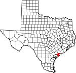
Calhoun County, Texas Basics:
Calhoun County Texas - Government Site
Population: 21,609
Area: 507 square miles
County seat: Port Lavaca
Area code(s) in use: 361
Time zone: CST
High school graduate or higher: 76.0%
Bachelor's degree or higher: 15.2%
Median household income: $45,122
Persons in poverty: 17.4%
Home ownership rate: 71.5%
Mean travel time to work: 20.2 minutes
Adjacent counties:
Aransas Jackson Refugio Victoria
Places in Calhoun County, Texas
Aransas National Wildlife Refuge Airport,
Big Duke's Place Airport,
Calhoun County Airport,
CIG 806 Heliport,
Green Lake Ranch Airport,
HHI-Port O'Connor Heliport,
Memorial Medical Center Heliport,
Phi Heliport,
Port O'Connor Base,
Port O'Connor Private Airport,
Sterling Airport,
Tanner's Airport,
Whatley Flying Service Airport Bill Days Reef,
Everett Reef,
Gallinipper Reef (historical),
Huisache Cove,
Josephine Reef,
Panther Reef,
Sand Point Reef Barroom Bay,
Big Pocket,
Bray Cove,
Cedar Lake,
Chocolate Bay,
Corey Cove,
Cox Bay,
Espiritu Santo Bay,
Guadalupe Bay,
Hynes Bay,
Keller Bay,
Lavaca Bay,
Lighthouse Cove,
Long Lake,
Mission Lake,
Panther Point Lake,
Pats Bay,
Rahal Bayou,
San Antonio Bay,
Shoalwater Bay,
South Pass Lake,
Twin Lakes,
Whitakers Bayou A C Louwien Bakery,
Calhoun County Courthouse,
Calhoun County Emergency Medical Service,
Calhoun County Jail,
Calhoun County Museum,
Calhoun County Public Library,
Calhoun County Sheriff's Office,
Magnolia Beach Volunteer Fire Department,
Olivia - Port Alto Volunteer Fire Department / Emergency Medical Service,
Point Comfort Police Department,
Point Comfort Volunteer Fire Department,
Port Lavaca Fire Department Station 1,
Port Lavaca Fire Department Station 2,
Port Lavaca Fire Marshal's Office,
Port Lavaca Police Department, Port O'Connor Branch Library,
Port O'Connor Volunteer Fire and Emergency Medical Service,
Seadrift Area Volunteer Emergency Medical Services, Seadrift Branch Library,
Seadrift Police Department GBRA Diversion Canal,
Victoria Barge Canal Ayres Point,
Bayucos Point,
Bendewald Point,
Bennett Point,
Cedar Point,
Cox Point,
Dagger Point,
False Live Oak Point,
Foster Point,
Gallinipper Point,
Grassy Point,
Indian Point,
Keeran Point,
Live Oak Point,
Mailboat Point,
Marsh Point,
Mosquito Point,
Mud Point,
Noble Point,
Panther Point,
Point Comfort,
Rhodes Point,
Rupert Point,
Sand Point,
Schicke Point,
Schicke Point,
Swan Point,
Teller Point,
West Point Clark Family Cemetery,
Hatch Cemetery,
Indianola Cemetery,
Little Marys Grave,
Old Town Cemetery,
Port Lavaca Cemetery,
Ranger Cemetery,
Seadrift Cemetery,
Six Mile Cemetery,
Stiernberg Cemetery Port O'Connor Census Designated Place Carancahua Pass,
Fishermans Cut,
Little Marys Cut,
Mailboat Channel,
Mitchells Cut,
Panther Reef Cut,
Pass Cavallo,
Powderhorn Bayou,
South Pass,
Steamboat Pass,
Taylor Cut Alamo Heights Baptist Church,
Christ Community Church,
Cornerstone First Assembly of God Church,
Episcopal Church Grace Parish,
First Baptist Church,
First Presbyterian Church,
New Life Apostolic Church,
Olivia Eden Church,
Our Lady of the Gulf Catholic Church,
Parkway by the Bay Baptist Church,
Saint Joseph Baptist Church,
Second Baptist Church,
Sixmile Church Clear Lake Levee,
Coxs Creek Dam,
Dredge Spoil Lake Levee,
Evaporation Lake Dam,
Evaporation Lake Number 1 Levee,
Evaporation Lake Number 2 Levee,
Evaporation Lake Number 3 Levee,
Mud Lake Number 4 Levee,
Operating Basin Number 1 Levee,
Operating Basin Number 31 Levee,
Operating Basin Number 4 Levee,
Operating Basin Number 5 Levee,
Raw Water Lake Levee,
Station 1888 Dam,
Storm Lake Levee Big Bayou,
Boggy Bayou,
Broad Bayou,
Fishermans Cut,
LaSalle Bayou,
Little Marys Cut,
Mitchells Cut,
Mule Slough,
Redfish Slough,
Saluria Bayou,
Varnum Bayou Harbor of Refuge,
Storm Harbor Memorial Medical Center Bayucos Island,
Big Bird Island,
Blackberry Island,
Dewberry Island,
Farwell Island,
First Chain of Islands,
Grass Island,
Grass Island,
Indianola Island,
Kamey Island,
Kenyon Island,
Little Bird Island,
Long Island,
Matagorda Island,
Pelican Island,
Second Chain of Islands,
South Pass Island,
Steamboat Island,
Turnstake Island,
Vanderveer Island Alligator Slide Lake,
Big Brundrett Lake,
Big Dam Bayou,
Big Tree Lake,
Blind Bayou,
Buffalo Lake,
Contee Lake,
Cottonwood Bayou,
Fish Pond,
Goff Bayou,
Green Lake,
Huckleberry Bayou,
Jones Bayou,
Jones Lake,
McMullen Lake,
Mud Lake,
Mustang Lake,
Old Town Lake,
Powderhorn Lake,
Power Lake,
Pringle Lake,
Redfish Lake,
Salt Lake,
Shell Reef Bayou,
Swan Lake,
Wild Hog Lake Alamo Beach,
Alligator Head Boat Sheds Marina,
At Last Marina,
Indianola Fishing Center Marina,
Lavaca Causeway Marina,
Matagorda,
Matagorda Island Lighthouse,
Nautical Landing Marina,
Port Alto Boat Shed Marina,
S and S Marina,
Saluria,
Wynne Ranch Heyser Oil Field,
Long Mott Oil Field,
Powderhorn Lake Oil Field Aransas National Wildlife Refuge,
Fishing Pier Park,
Matagorda Island State Park,
Matagorda Island Wildlife Management Area,
Swan Point Park,
Tilley Park,
Welder Flats Wildlife Management Area Alamo Beach, Caballo (historical), Calhoun (historical),
Clark Station, Crescent Village (historical), Dimmits Landing (historical),
El Campo Club Community,
Green Lake,
Heyser,
Indianola, Indianola (historical),
Kamey, La Salle (historical), La Salle Fort (historical),
Long Mott,
Magnolia Beach,
North Seadrift,
Olivia,
Point Comfort,
Port Alto,
Port Lavaca,
Port O'Connor, Saluria (historical),
Schicke Point Community,
Seadrift,
Sixmile Port Lavaca Post Office,
Port O'Connor Post Office Clear Lake,
Coxs Creek Reservoir,
Dredge Spoil Lake,
Evaporation Lake,
Evaporation Lake Number 1,
Evaporation Lake Number 2,
Evaporation Lake Number 3,
Mud Lake Number 4,
Operating Basin Number 1,
Operating Basin Number 31,
Operating Basin Number 4,
Operating Basin Number 5,
Raw Water Lake,
Storm Lake Calhoun County Juvenile Justice Alternative Education Program, Calhoun High School,
Calhoun High School,
Cornerstone Christian Academy,
Harrison Jefferson Madison Elementary School,
Hope High School,
Jackson - Roosevelt Elementary School,
Olivia School,
Our Lady of the Gulf Catholic School, Point Comfort Elementary School,
Port Comfort Elementary School, Port O Connor Elementary School,
Port O'Connor Elementary School,
Roemerville School,
Seadrift Elementary School, Seadrift School,
Six Mile A / G Christian School,
Travis Middle School,
Wilkins School El Agua Dulce Spring,
Johnson Spring, Kabela Springs, Ojos de Aguas Dulce Spring (historical),
San Luis Springs, Walker Springs (historical)
Black Bayou,
Boggy Bayou,
Chocolate Bayou,
Coloma Creek,
Cox Creek,
East Coloma Creek,
Guadalupe River,
Hog Bayou,
Kuy Creek,
Little Chocolate Bayou,
Lynn Bayou,
Mamie Bayou,
North Guadalupe River,
San Antonio River,
Schwings Bayou,
Sixmile Creek,
South Guadalupe River,
Swimming Pen Slough,
Townsend Bayou,
West Coloma Creek Josephine Motte Live Oaks Bayou KGUL-AM (Port Lavaca),
KPLV-FM (Port Lavaca) Matagorda Island State Park Trail,

