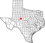
Coke County, Texas Basics:
Coke County Texas - Government Site
Population: 3,223
Area: 911 square miles
County seat: Robert Lee
Area code(s) in use: 325
Time zone: CST
High school graduate or higher: 85.5%
Bachelor's degree or higher: 16.1%
Median household income: $40,844
Persons in poverty: 13.4%
Home ownership rate: 72.4%
Mean travel time to work: 23.1 minutes
Adjacent counties:
Mitchell Nolan Runnels Sterling Tom Green
Places in Coke County, Texas
Robert Lee Airport Bee Hollow,
Butterfield Draw,
Hudson Draw,
Murph Draw,
Perry Draw,
Shoonover Draw,
T F Draw Fox Hollow,
Humble Neck Elm Bend Bronte Volunteer Fire Department,
Coke County Jail, Coke County Library, Coke County Museum,
East Coke County Ambulance Service,
Perkins Plant,
Robert Lee Volunteer Fire Department,
West Coke County Emergency Medical Services Bonner Point,
Gulf Peninsula,
Hendry Point,
McDowell Point,
Pace Point,
Rocky Point,
Scenic Point,
Stone Point Cedar Hill Cemetery,
Fairview Cemetery,
Fort Chadbourne Cemetery,
Fort Chadbourne Cemetery,
Hayrick Cemetery,
Indian Creek Cemetery,
Mule Creek Cemetery,
Paint Creek Cemetery,
Ross Cemetery Bronte Church of Christ,
Pecan Church Shelving Rock Bluff,
Wiley Bluff Edward Rawling Lower Tank Dam,
Edward Rawling Upper Tank Dam,
Mountain Creek Dam,
Nan Hatty Tank Dam,
Oak Creek Dam,
Old City Lake Dam,
Old City Lake Dam,
Robert Lee Dam,
Soil Conservation Service Site 1 Dam,
Soil Conservation Service Site 2 Dam,
Soil Conservation Service Site 3 Dam,
Soil Conservation Service Site 4 Dam,
Soil Conservation Service Site 5 Dam,
Soil Conservation Service Site 6 Dam,
W D Coleman Lake Dam Coxs Gap,
Panther Gap,
Panther Gap Big Windmill,
Bull Pasture Windmill,
Divide,
Green Mountain Community Center,
Hatley Windmill,
Head of the Creek Windmill,
Holiman Ranch,
Munn Ranch,
Peter L Windmill,
Schooler Windmill,
Scrub Oak Ranch,
Sterman Windmill,
Turner Ranch Headquarters,
Valley View,
Whiteside Ranch,
Williams Windmill Bronte Oil Field,
I A B Oil Field,
Jameson-Strawn Oil Field,
Lygay Oil Field,
McCuthen Oil Field,
Millican Oil Field,
Munn Oil Field,
Rawlings Oil Field,
South Lygay Oil Field,
Wendland Oil Field Fort Chadbourne,
Gladney Field,
Lake View Park,
Paint Creek Park,
Rough Creek Park,
Wildcat Creek Park Bronte, Cedar Hill (historical),
Edith, Flint Hill (historical),
Fort Chadbourne, Hayrick (historical), Mule Shoe (historical),
Pecan Mott,
Robert Lee,
Sanco,
Shawville,
Silver,
Tennyson Bronte Post Office,
Robert Lee Post Office,
Tennyson Post Office E V Spence Reservoir,
E V Spence Reservoir,
Edward Rawling Lower Tank,
Edward Rawling Upper Tank,
Helfer Creek Tank,
Lake E V Spence,
Mountain Creek Reservoir,
Nan Hatty Tank,
Oak Creek Reservoir,
Old City Lake,
Old City Lake,
Oscar Tank,
Pyramid Tank,
Scudday Tank,
Soil Conservation Service Site 1 Reservoir,
Soil Conservation Service Site 2 Reservoir,
Soil Conservation Service Site 3 Reservoir,
Soil Conservation Service Site 4 Reservoir,
Soil Conservation Service Site 5 Reservoir,
Soil Conservation Service Site 6 Reservoir,
W D Coleman Lake,
Wildcat Tank Liveoak Ridge Bronte Early Childhood Center,
Bronte Elementary School,
Bronte High School,
Fairview Accelerated Learning Center,
Fairview Behavior Adjustment School, Miles Vocational Training, Robert Lee Elementary School, Robert Lee High School, Water Valley Vocational School,
Wildcat School Buffalo Spring,
Cosby Spring,
Dripping Springs,
Hidden Spring,
Houston Springs,
Mule Creek Spring Antelope Creek,
Antelope Creek,
Bitter Creek,
Bouzier Creek,
Buffalo Creek,
Cement Creek,
Cobb Creek,
Cow Creek,
Cow Creek,
Double Barrel Creek,
Dry Creek,
East Kickapoo Creek,
Gasconades Creek,
Gobbler Creek,
Indian Creek,
Jack Miles Creek,
Juniper Creek,
Kaiser Creek,
Kates Creek,
Kickapoo Creek,
Little Walnut Creek,
Live Oak Creek,
Liveoak Creek,
Machae Creek,
Meadow Creek,
Messbox Creek,
Middle Kickapoo Creek,
Mountain Creek,
Mule Creek,
North Pecan Creek,
Paint Creek,
Pecan Creek,
Ross Creek,
Rough Creek,
Rough Creek,
Rough Creek,
Salt Creek,
Sand Creek,
Storey Creek,
Turkey Creek,
Walnut Creek,
West Kickapoo Creek,
Wildcat Creek,
Williams Branch,
Willmo Sand Creek,
Yellow Wolf Creek Brooks Hill,
Butterfield Peak,
Buttermilk Hill,
Cedar Mountain,
Cement Mountain,
Dead Indian Mountain,
Deadman Hill,
Durham Peak,
Goat Mountain,
Gobbler Hill,
Green Mountain,
Hayrick Mountain,
Hog Mountain,
Horse Mountain,
Jones Peak,
Juniper Peak,
Kickapoo Mountain,
Kiser Mountain,
Little Round Mountain,
Lone Mountain,
Meadow Mountain,
Millican Mountains,
Mount Margaret,
Nipple Peak,
Nipple Peak,
Sand Hill,
Shaggy Peak,
Silver Peak,
Wildcat Mountain,
Wilson Mountain KTEO-FM (San Angelo) Butterfield Canyon,
Cemetery Draw,
Deadman Canyon,
Grubs Canyon,
Hog Canyon,
Horse Canyon,
Lock Canyon,
Long Canyon,
Natural Well Draw,
Panther Draw,
Spring Canyon,
Sterman Canyon,
Wildcat Canyon,
Williams Draw,

