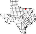
Cooke County, Texas Basics:


Cooke County Texas - Government Site

Population: 38,726
Area: 875 square miles
County seat: Gainesville
Area code(s) in use: 940
Time zone: CST
High school graduate or higher: 82.6%
Bachelor's degree or higher: 17.4%
Median household income: $49,735
Persons in poverty: 13.9%
Home ownership rate: 69.9%
Mean travel time to work: 24.5 minutes


Adjacent counties:
Denton  Grayson  Love (OK)  Marshall (OK)  Montague  Wise  

Find in Texas

Map of the Cooke County area


Our detail map of Cooke County shows the Cooke County, Texas boundary lines and other interesting items.

Places in Cooke County, Texas

  Airports     show all on map

Bucker Field Airport, Comet Landing Strip, Dreamland Airport, Edgington Ranch Airport, Flying R Ranch Airport, Freedom Field Airport, Gainesville Municipal Airport, Hardy Field Airport, Hayesport Airport, Melody Ranch Airport, Robotek Airport, Ruby Field Airport, Tailwheel Acres Airport, The 88 Airport, Three Acres Airport, Tightwaad Air Ranch Airport

  Bends     show all on map

Delaware Bend, Frog Bottom, Horseshoe Bend, Sivells Bend, Tyas Bend, Walnut Bend, Warrens Bend

  Buildings     show all on map

Callisburg Volunteer Fire Department, Cloud-Stark House, Cooke County Constable's Office Precinct 4, Cooke County Emergency Medical Service, Cooke County Highway Patrol, Cooke County Jail, Cooke County Library, Cooke County Sheriff's Department, Era Volunteer Fire Department, Gainesville Fire Department Station 1, Gainesville Fire Department Station 2, Gainesville Fire Department Station 3, Gainesville Police Department, Lake Kiowa Volunteer Fire Department, Lake Kiowa Volunteer Fire Department Station 2, Lindsay Police Department, Lindsay Volunteer Fire Department, Morton Museum of Cooke County, Moss Lake Volunteer Fire Department, Muenster Police Department, Muenster Public Library, Muenster Volunteer Fire Department, Myra Volunteer Fire Department, Oak Ridge Police Department, Oak Ridge Volunteer Fire Department, Rosston Volunteer Fire Department, Thomason-Scott House, Valley View Police Department, Valley View Volunteer Fire Department, William and Anna Davis House

  Cemeteries     show all on map

Able Cemetery, Akers Cemetery, Bacon Cemetery, Barlow Cemetery, Barron Cemetery, Bear Head Cemetery, Bewley Cemetery, Black Cemetery, Bloomfield Cemetery, Brushy Mound Cemetery, Callisburg Cemetery, Center Hill Cemetery, Clark County Cemetery, Cogburn Cemetery, Coker Cemetery, Dervin Cemetery, Era Cemetery, Este Cemetery, Fairview Cemetery, Gunter Cemetery, Hayes Cemetery, Herod-Morris Cemetery, High Point Cemetery, Hood Cemetery, Johnson Cemetery, Liberty Hill Cemetery, Morris Cemetery, Moss Cemetery, Mount Olive Cemetery, Mount Zion Cemetery, Nelson Grove Cemetery, New Hope Cemetery, Newell Cemetery, Oak Grove Cemetery, Oak Hill Cemetery, Red River Cemetery, Redmond Cemetery, Reed Cemetery, Rest Haven Memorial Cemetery, Roberts Cemetery, Scanland Cemetery, Shiloh Cemetery, Turner Cemetery, Union Hill Cemetery, Valley View Cemetery, Van Syke Cemetery, Walling Cemetery, Weaver Cemetery, Williams Cemetery

  Census     show all on map

Lake Kiowa Census Designated Place

  Churches     show all on map

Antioch Baptist Church, Bible Baptist Church, Calvary Church, Church of Christ, Concord Church, Corinth Baptist Church, Cornerstone Baptist Church, Dixon Creek Church, Dye Church, Faith Temple Church, First Baptist Church, First Church of the Nazarene, First Presbyterian Church, First United Pentecostal Church, Garden Valley Church, Grand Avenue Baptist Church, Grand Avenue Church, Harvest Time Church of God, Harvey Street Baptist Church, Hibbit Church, House of Prayer Assembly of God Church, Indian Creek Church, Jehovahs Witnesses Church, Mission United Methodist Church, Mount Hope Church, Mount Hope Church, Mount Lebanon Church, Mount Olive Baptist Church, Mount Pleasant Church, Mount Zion Church, Mount Zion Number 2 Church, Muller Street Church of Christ, New Hope Church, Old Mount Olive Baptist Church, Prairie Grove Baptist Church, Prairie Grove Church, Saint James Church, Saint Marys Catholic Church, Saint Peters Roman Catholic Church, Shady Grove Church, Shiloh Church, Southside Baptist Church, Spring Creek Church, Spring Grove Church, Temple Baptist Church, Temple Church, Tipton Chapel, Trinity Temple Church of God in Christ, Violott Church, Westview Church

  Cliffs     show all on map

Rock Bluff, Tyler Bluff, White Bluff

  Dams     show all on map

B and L Ranch Dam, Bing Lake Dam, Collums Lake Dam, Fish Creek Dam, Harville Lake Dam, Lake Dealey Dam, Lake Kiowa Dam, North Club Lake Dam, Sarles Lake Dam, Soil Conservation Service Site 11b Dam, Soil Conservation Service Site 12 Dam, Soil Conservation Service Site 15 Dam, Soil Conservation Service Site 16 Dam, Soil Conservation Service Site 16b Dam, Soil Conservation Service Site 17 Dam, Soil Conservation Service Site 18 Dam, Soil Conservation Service Site 19 Dam, Soil Conservation Service Site 19 Dam, Soil Conservation Service Site 2 Dam, Soil Conservation Service Site 21 Dam, Soil Conservation Service Site 3 Dam, Soil Conservation Service Site 32 Dam, Soil Conservation Service Site 33 Dam, Soil Conservation Service Site 34 Dam, Soil Conservation Service Site 35 Dam, Soil Conservation Service Site 36 Dam, Soil Conservation Service Site 4 Dam, Soil Conservation Service Site 43a Dam, Soil Conservation Service Site 45 Dam, Soil Conservation Service Site 46 Dam, Soil Conservation Service Site 47 Dam, Soil Conservation Service Site 48 Dam, Soil Conservation Service Site 52 Dam, Soil Conservation Service Site 5a Dam, Soil Conservation Service Site 5b Dam, Soil Conservation Service Site 60 Dam, Soil Conservation Service Site 61cc Dam, Soil Conservation Service Site 61d Dam, Soil Conservation Service Site 61f Dam, Soil Conservation Service Site 61g Dam, Soil Conservation Service Site 61k Dam, Soil Conservation Service Site 61l Dam, Soil Conservation Service Site 61q Dam, Soil Conservation Service Site 61t Dam, Soil Conservation Service Site 61u Dam, Soil Conservation Service Site 61v Dam, Soil Conservation Service Site 61w Dam, Soil Conservation Service Site 61x Dam, Soil Conservation Service Site 6a1 Dam, Soil Conservation Service Site 6b Dam, Soil Conservation Service Site 6e Dam, Soil Conservation Service Site 6h Dam, Soil Conservation Service Site 6i Dam, Soil Conservation Service Site 6j2 Dam, Soil Conservation Service Site 6k2 Dam, Soil Conservation Service Site 6l Dam, Soil Conservation Service Site 6m Dam, Soil Conservation Service Site 6n Dam, Soil Conservation Service Site 7a Dam, Soil Conservation Service Site 7b Dam, Soil Conservation Service Site 7c Dam, Soil Conservation Service Site 7d Dam, Soil Conservation Service Site 7f Dam, Soil Conservation Service Site 7g Dam, Soil Conservation Service Site 9 Dam, Tipps Lake Dam

  Hospitals     show all on map

Gainesville Memorial Hospital, Muenster Memorial Hospital, North Texas Medical Center

  Locales     show all on map

Camp Sweeney, Santa Fe Passenger Depot

  Military     show all on map

Gainesville Army Air Field (historical)

  Oilfields     show all on map

Anderson-Kerr Oil Field, Brewer Oil Field, Bundy Oil Field, Callisburg Oil Field, Dangel Oil Field, Dove Oil Field, Ellenburger Oil Field, Gatewood Oil Field, Gruber Oil Field, Jacobs Oil Field, Ranbalm Oil Field, Sivells Bend Oil Field, South Dove Oil Field, The Wilson Pool, Timber Creek Oil Field, Underwood Oil Field, Voth Oil Field, Walnut Bend Oil Field, Woodbine Oil Field

  Parks     show all on map

Edison Park, Hornet Stadium, Horseshoe Bend Recreation Area, Leeper Stadium, Leonard Park, Leopard Stadium, Lindsey Park, Moffitt Park, Muenster High School Football Stadium, Sacred Heart High School Football Field, Site of Fort Fitzhugh

  Populated Places     show all on map

Balm, Bloomfield, Bulcher, Bulcher (historical), Burns City, Callisburg, Coesfield, Cook, Custer City, Custer City (historical), Dexter, Era, Freemound, Gainesville, Hemming, Hood, Hope, Lake Kiowa, Leo, Lindsay, Lois, Marysville, Mountain Springs, Muenster, Myra, Oak Ridge, Orlena (historical), Prairie Point, Rosston, Shady Grove, Sivells Bend, Sturgeon, Valley View, Walnut Bend, Woodbine

  Post Offices     show all on map

Era Post Office, Gainesville Post Office, Lindsay Post Office, Muenster Post Office, Myra Post Office, Rosston Post Office, Valley View Post Office

  Reservoirs     show all on map

B and L Ranch Lake, Bing Lake, Collums Lake, Harville Lake, Hubert M Moss Lake, Lake Dealey, Lake Kiowa, North Club Lake, Sarles Lake, Soil Conservation Service Site 11b Reservoir, Soil Conservation Service Site 12 Reservoir, Soil Conservation Service Site 15 Reservoir, Soil Conservation Service Site 16 Reservoir, Soil Conservation Service Site 16b Reservoir, Soil Conservation Service Site 17 Reservoir, Soil Conservation Service Site 19 Reservoir, Soil Conservation Service Site 19 Reservoir, Soil Conservation Service Site 2 Reservoir, Soil Conservation Service Site 21 Reservoir, Soil Conservation Service Site 3 Reservoir, Soil Conservation Service Site 32 Reservoir, Soil Conservation Service Site 33 Reservoir, Soil Conservation Service Site 34 Reservoir, Soil Conservation Service Site 35 Reservoir, Soil Conservation Service Site 36 Reservoir, Soil Conservation Service Site 4 Reservoir, Soil Conservation Service Site 43a Reservoir, Soil Conservation Service Site 45 Reservoir, Soil Conservation Service Site 46 Reservoir, Soil Conservation Service Site 47 Reservoir, Soil Conservation Service Site 48 Reservoir, Soil Conservation Service Site 52 Reservoir, Soil Conservation Service Site 5a Reservoir, Soil Conservation Service Site 5b Reservoir, Soil Conservation Service Site 60 Reservoir, Soil Conservation Service Site 61cc Reservoir, Soil Conservation Service Site 61d Reservoir, Soil Conservation Service Site 61f Reservoir, Soil Conservation Service Site 61g Reservoir, Soil Conservation Service Site 61k Reservoir, Soil Conservation Service Site 61l Reservoir, Soil Conservation Service Site 61q Reservoir, Soil Conservation Service Site 61t Reservoir, Soil Conservation Service Site 61u Reservoir, Soil Conservation Service Site 61v Reservoir, Soil Conservation Service Site 61w Reservoir, Soil Conservation Service Site 61x Reservoir, Soil Conservation Service Site 6a1 Reservoir, Soil Conservation Service Site 6b Reservoir, Soil Conservation Service Site 6e Reservoir, Soil Conservation Service Site 6h Reservoir, Soil Conservation Service Site 6i Reservoir, Soil Conservation Service Site 6j2 Reservoir, Soil Conservation Service Site 6k2 Reservoir, Soil Conservation Service Site 6l Reservoir, Soil Conservation Service Site 6m Reservoir, Soil Conservation Service Site 6n Reservoir, Soil Conservation Service Site 7a Reservoir, Soil Conservation Service Site 7b Reservoir, Soil Conservation Service Site 7c Reservoir, Soil Conservation Service Site 7d Reservoir, Soil Conservation Service Site 7f Reservoir, Soil Conservation Service Site 7g Reservoir, Soil Conservation Service Site 9 Reservoir, Soil Conservation Service Site Number 18 Reservoir, Tipps Lake

  Ridges     show all on map

Nubbin Ridge, The Backbone, Wolf Ridge

  Schools     show all on map

Burton School, Callisburg High School, Callisburg Junior High School, Cooke County Junior College, Edison Elementary School, Era School, Franklin School, Gainesville Alternative School, Gainesville High School, Gainesville Junior High School, Gainesville State School for Girls, J M Lindsay Elementary School, Lindsay Elementary School, Lindsay High School, Lindsay School, McMurray Elementary School, McMurray School, Muenster Elementary School, Muenster High School, Rad Ware Elementary School, Rad Ware School, Robert E Lee Intermediate School, Robert E Lee School, Saint Mary School, Saint Peter School, Sivells Bend Elementary School, Sivells Bend School, Valley View Elementary School, Valley View High School, Walnut Bend Elementary School, Walnut Bend School, Washington School

  Springs     show all on map

Bluff Springs, Brothers Springs, Cove Springs, Cox Springs, Davidson Springs, Dripping Spring, Fitzhugh Springs (historical), Indian Springs, Mountain Springs (historical), Pecan Spring, Rour Springs, Spring Grove Springs, Tartar Springs, Valley View Springs (historical)

  Streams     show all on map

Bear Head Creek, Bingham Creek, Bircham Creek, Blocker Creek, Brewster Creek, Brushy Elm Creek, Buck Creek, Buck Creek, Buck Creek, Camp Creek, Cedar Creek, Coons Creek, Cove Hollow Creek, Davenport Branch, Dixon Creek, Dozier Creek, Dry Elm Creek, East Mountain Creek, Fannin Creek, Fish Creek, Flat Creek, Gibbons Branch, Hackley Creek, Hickory Creek, Hunter Branch, Indian Creek, Indian Creek, Jenny Creek, Johns Branch, Landers Branch, Lick Creek, Little Indian Creek, Long Branch, Long Branch, Loring Branch, Mass Creek, Montague Creek, North Fish Creek, Pecan Creek, Pecan Creek, Persimmon Creek, Pierce Spring Branch, Pitman Branch, Redmond Branch, Rio Branch, Rock Creek, Rock Creek, Scott Creek, South Fish Creek, Spring Creek, Squirrel Creek, Sycamore Creek, Timber Creek, Tonkawa Creek, Townsend Creek, Tuttle Branch, Valley Branch, Valley Creek, Waller Creek, Walnut Branch, Wheat Creek, Wheeler Creek, Wilburn Branch, Wildcat Creek, Williams Creek, Willow Creek, Wolf Creek

  Summits     show all on map

Mount Olive, Terrapin Hill, Three Mounds

  Towers     show all on map

KDGE-FM (Gainesville), KDGE-FM (Gainesville), KGAF-AM (Gainesville), KXGM-FM (Muenster)

  Trails     show all on map

Leonard Park Trail

  Valleys     show all on map

Birchum Hollow, Black Hollow, Blue Hollow, Cove Hollow, Norfleet Hollow, Opossum Hollow, Owl Hollow,

Cooke County, Texas Population By Race (2012 estimate)

RacePopulation
WhiteCooke County White population 35,93835,937  
BlackCooke County Black population 1,2391,239
MixedCooke County Mixed population 620619
American IndianCooke County American Indian population 503503
AsianCooke County Asian population 387387
Hawaiian & Pacific IslanderCooke County Hawaiian & Pacific Islander population 00

Additional population tables :
State population table
Texas population by county