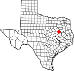
Freestone County, Texas Basics:


Freestone County Texas - Government Site

Population: 19,483
Area: 878 square miles
County seat: Fairfield
Area code(s) in use: 254 903
Time zone: CST
High school graduate or higher: 78.8%
Bachelor's degree or higher: 12.9%
Median household income: $45,510
Persons in poverty: 15.1%
Home ownership rate: 77.0%
Mean travel time to work: 24.8 minutes


Adjacent counties:
Anderson  Henderson  Leon  Limestone  Navarro  

Find in Texas

Map of the Freestone County area


Our detail map of Freestone County shows the Freestone County, Texas boundary lines and other interesting items.

Places in Freestone County, Texas

  Airports     show all on map

Big Brown Creek Airstrip, Moore HX Ranch Airport, Pyramid Ranch Airport, Teague Municipal Airport

  Bends     show all on map

Chandler Bottom

  Buildings     show all on map

Burlington-Rock Island Railroad Museum, Butler Volunteer Fire Department, Daniel Memorial Childrens Home, Dew Volunteer Fire Department, Fairfield City Fire Department, Fairfield Emergency Medical Service Ambulance, Fairfield Library, Fairfield Police Department, Fairfield Volunteer Fire Department, Freestone County Constable's Office Precinct 1, Freestone County Constable's Office Precinct 3, Freestone County Historical Museum, Freestone County Jail, Freestone County Sheriff's Office, Southern Oaks Volunteer Fire Department, Teague District Emergency Medical Services, Teague Police Department, Teague Public Library, Teague Volunteer Fire Department, Texas Department of Criminal Justice Region 2 William R Boyd Unit, Trinity and Brazos Valley Railroad Depot and Office Building, Wortham Police Department, Wortham Volunteer Fire Department

  Cemeteries     show all on map

Antioch Cemetery, Brooke Cemetery, Cedar Grove Cemetery, Chancellor Cemetery, Day Cemetery, Driver Cemetery, Edwards Cemetery, George Cemetery, Greenbriar Cemetery, Greenwood Cemetery, Grove Island Cemetery, Harrison Chapel Cemetery, Hickory Grove Cemetery, Holly Grove Cemetery, Hopewell Cemetery, Johnson Cemetery, Kendrick Cemetery, Lakes Chapel Cemetery, Lee Cemetery, Long Bottom Cemetery, Mayes Cemetery, Miller Cemetery, Mount Zion Cemetery, New Hope Cemetery, Oak Grove Cemetery, Oak Island Cemetery, Old Anglon Cemetery, Old Zion Cemetery, Philpott Cemetery, Plum Creek Cemetery, Post Oak Cemetery, Post Oak Cemetery, Red Cemetery, Rehobath Cemetery, Salem Cemetery, Sand Hill Cemetery, Session Cemetery, Shanks Cemetery, Spillers Cemetery, Tyus Cemetery, Varnell Cemetery, Webb-Branch Cemetery, Willis Cemetery, Wilsons Chapel Cemetery, Woodland Cemetery

  Churches     show all on map

Antioch Church, Antioch Church, Bethel Church, Brown Chapel, Calvary Baptist Church, Caney Church, Cedar Creek Church, Church of Christ, Clay Hill Church, Crescent Chapel, Faith Hope Love Baptist Church, First Baptist Church, Friendship Church, Gibson Chapel, Greenbriar Church, Harp Church, Hillery Chapel, Hopewell Church, Jehovahs Witnesses Church, Jerusalem Church, Jerusalem Church, Lebanon Church, Little Star Church, Longs Church, Mount Pleasant Church, Mount Zion Church, Mount Zion Church, New Hope Church, New Spring Seat Church, Owens Chapel, Pilgrim Rest Church, Pine Hill Church, Pine Top Church, Pleasant Grove Church, Post Oak Church, Rhode Island Church, Rocky Branch Church, Rocky Mount Church, Round Prairie Baptist Church, Round Prairie Church, Saint James United Methodist Church, Saint Marys Catholic Church, Salem Church, Salem Church, Sand Hill Church, Shiloh Church, Shiloh Church, Spring Seat Church, Tehuacana Grove Church, Tidus Chapel, Trinity Lutheran Church, Union Chapel, Union Church, Union Prim Church, Waymon Chapel, Wesley Church, Westside Church of Christ, Wilson Chapel

  Cliffs     show all on map

Walker Bluff

  Dams     show all on map

Blackbird Lake Dam, Blue Lake Dam, Burleson Lake Dam, City Lake Dam, Connolly Lake Dam, Couch Lake Dam, Emerson Dam Number 1, Emerson Dam Number 2, Fairfield Dam, Harding Lake Dam, Hogshead Lake Dam, Hunt Ranch Lake Dam Number 1, Hunt Ranch Lake Dam Number 2, Indian Creek Lake Dam, Jones Lake Dam, Lipsey Lake Dam, Lipsey Lake Dam Number 2, Little Red Lake Dam, Loper Lake Dam, Lower Club Lake Dam, Morse Lake Dam, Pearson Lake Dam, Plum Creek Ranch Dam, Red Lake Dam, Red Lake Number 3 Dam, Richards Lake Dam, S C Pickins Dam, Snider Lake Dam, Streetman Lake Dam, T B Pickens Dam, Texas No Name Number 12 Dam, Upper Club Lake Dam, Wilson Lake Dam, Wortham Lake Number 1 Dam, Wortham Lake Number 2 Dam

  Guts     show all on map

Hogpen Slough, Lindsey Slough

  Hospitals     show all on map

East Texas Medical Center

  Lakes     show all on map

Cook Lake, Hillside Slough, Lake Port, Little Lake, Long Lake, Lost Lake, Patterson Lake, Pea Patch Lake, Smith Lake, Snag Lake, Sneed Lake, Snyder Lake, Timber Lake, Walker Lake, Yonker Pin Slough

  Locales     show all on map

Amerada Camp, Banks Stop, Gude, Hodge Podge Lodge, Sand Hill

  Oilfields     show all on map

Bi-Stone Oil Field, Oakwood Dome Oil Field, Stewards Mill Oil Field, Wortham Oil Field

  Parks     show all on map

Fairfield Arena, Fairfield Lake State Park, Gregory Field, Mount Zion Park, Richland Creek Wildlife Management Area

  Populated Places     show all on map

Avant Prairie, Bonnerville, Butler, Concord, Cotton Gin, Dew, Donie, Fairfield, Freestone, Kirvin, Lanely, Luna, Marshy Springs, Plum Creek, Red Lake, Rhode Island, Saint Elmo, Simsboro, Stewards Mill, Streetman, Teague, Troy (historical), Turlington, Ward Prairie, Winkler, Wortham, Young

  Post Offices     show all on map

Donie Post Office, Fairfield Post Office, Kirvin Post Office, Streetman Post Office, Teague Post Office, Wortham Post Office

  Reservoirs     show all on map

Blackbird Lake, Blue Lake, Burleson Lake, Connolly Lake, Couch Lake, Donie Reservoir, Emerson Lake Number 1, Emerson Lake Number 2, Evans Lake, Fairfield Lake, Harding Lake, Hogshead Lake, Hunt Ranch Lake Number 1, Hunt Ranch Lake Number 2, Indian Creek Lake, Jones Lake, Lipsey Lake, Lipsey Lake Number 2, Little Red Lake, Loper Lake, Lower Club Lake, Morse Lake, Pearson Lake, Plum Creek Ranch Lake, Red Lake, Red Lake Number 3, Richards Lake, S C Pickins Lake, Snider Lake, Streetman Lake, T B Pickens Lake, Teague City Lake, Upper Club Lake, Wilson Lake, Wortham Lake, Wortham Lake Number 1, Wortham Lake Number 2

  Ridges     show all on map

High Ridge

  Schools     show all on map

Booker T Washington School, Butler High School, Dew Elementary School, Dogan Elementary School, Dogan High School, Fairfield Elementary School, Fairfield High School, Fairfield Intermediate School, Fairfield Junior High School, Furney-Richardson School, Sallie Mounger Elementary School, Teague High School, Teague Intermediate School, Teague Junior High School, Trahin School, Trinity Chapel School, Wheeler High School, Wortham Elementary School, Wortham High School, Wortham Middle School

  Springs     show all on map

Big Spring, Cold Springs

  Streams     show all on map

Alligator Creek, Alum Branch, Alum Branch, Ball Branch, Batsmith Creek, Bear Branch, Bear Creek, Bee Branch, Bell Branch, Big Brown Creek, Blain Dugout, Bob Branch, Bow Branch, Brinkley Creek, Brook Spring Branch, Camp Creek, Camphouse Dugout, Caney Creek, Caroline Creek, Cash Branch, Cat Creek, Cedar Creek, Cedar Creek, Cedar Creek, Cedar Creek, Cedar Creek, Cedar Dugout, Church Creek, Cold Springs Branch, Cottonwood Creek, Cox Creek, Dottie Branch, Dowdy Branch, Dry Branch, Dry Branch, Dry Creek, Dry Creek, Edwards Creek, Elm Creek, Enloe Slough, Folsom Creek, Fulks Dugout, Gaston Branch, Graveyard Branch, Greenbriar Creek, Grindstone Creek, Grove Island Creek, Hanna Branch, Harpers Branch, Hausler Creek, Hayes Branch, Hog Creek, Hog Creek, Holly Branch, Indian Creek, Jackson Branch, Jelly Slough, Joe Creek, Linn Creek, Little Brown Creek, Little Sandy Creek, Little Tehuacana Creek, Malone Branch, Mill Branch, Mims Creek, Myrtal Branch, Negro Creek, North Fork Buffalo Creek, Patton Creek, Pin Oak Branch, Pin Oak Creek, Pine Branch, Pinoak Creek, Plum Creek, Powell Branch, Prairie Creek, Rena Branch, Richland Creek, Rock Springs Branch, Rocky Branch, Rocky Branch, Saline Branch, Sandy Creek, Self Creek, Silver Creek, Sistern Branch, Sloan Creek, Sneed Creek, Spring Branch, Tan Yard Branch, Tanbark Branch, Tanyard Branch, Taylor Springs Branch, Tehuacana Creek, Toms Creek, Waldrom Branch, Walnut Creek, Walthall Creek, White Rock Creek, White Rock Creek, Whitney Branch, Wilkerson Spring Branch, Willow Creek, Willow Creek, Wolf Creek

  Summits     show all on map

Burleson Hill, Folsom Hills, Pilot Knob

  Towers     show all on map

KNES-FM (Fairfield)

  Trails     show all on map

Fairfield Lake State Park Trails

  Wells     show all on map

Riley Springs Well,

Freestone County, Texas Population By Race (2012 estimate)

RacePopulation
WhiteFreestone County White population 15,58615,586  
BlackFreestone County Black population 3,1953,195
MixedFreestone County Mixed population 292292
American IndianFreestone County American Indian population 273272
AsianFreestone County Asian population 136136
Hawaiian & Pacific IslanderFreestone County Hawaiian & Pacific Islander population 00

Additional population tables :
State population table
Texas population by county