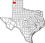
Hartley County, Texas Basics:


Hartley County Texas - Government Site

Population: 6,165
Area: 1462 square miles
County seat: Channing
Area code(s) in use: 806
Time zone: CST
High school graduate or higher: 80.1%
Bachelor's degree or higher: 19.8%
Median household income: $63,407
Persons in poverty: 7.3%
Home ownership rate: 68.5%
Mean travel time to work: 13.4 minutes


Adjacent counties:
Dallam  Moore  Oldham  Potter  Quay (NM)  Sherman  Union (NM)  

Find in Texas

Map of the Hartley County area


Our detail map of Hartley County shows the Hartley County, Texas boundary lines and other interesting items.

Places in Hartley County, Texas

  Airports     show all on map

Castleberry Ranch Airport, Dalhart Municipal Airport

  Buildings     show all on map

Channing Volunteer Fire Department and Emergency Service, Dalhart Emergency Medical Services, Hartley County Courthouse, Hartley Emergency Medical Services, Hartley Volunteer Fire Department, Texas Department of Criminal Justice Region 5 Dalhart Unit, XIT General Office

  Cemeteries     show all on map

Hartley Cemetery

  Census     show all on map

Hartley Census Designated Place

  Churches     show all on map

First Presbyterian Church, Lakeview United Methodist Church, Saint Anthonys Catholic Church

  Dams     show all on map

Martha Houghton Lake Number 1 Dam, Martha Houghton Lake Number 2 Dam, Martha Houghton Lake Number 3 Dam, Martha Houghton Lake Number 4 Dam, Rita Blanca Creek Reservoir Dam

  Hospitals     show all on map

Coon Memorial Hospital, Coon Memorial Hospital and Home

  Lakes     show all on map

Bass Hole, Catfish Hole, Lake Windmill, Mildred Lake

  Locales     show all on map

Antelope Windmill, Banks Windmill, Beale Queen Ranch, Beck Ranch, Bird Ranch Store, Bishop Camp, Bivins Channing Farm, Bivins Channing Ranch, Bryant Ranch, Camp Windmill, Castleberry Ranch, Cattail Windmill, Coldwater Community House, Coots Ranch, Cow Pasture Windmill, Cruz Windmill, Dammier Ranch, East Punta de Agua Windmill, East Windmill, Edlin Ranch, Flats Windmill, Full Blood Windmill, Green Tower Windmill, Hackberry Windmill, Hanbury Windmill, High Windmill, Houghton Ranch, Line Windmill, Little Nelson Windmill, Lone Tree Windmill, Low Draw Windmill, Martin Ranch, McCrory Ranch, McMordie Pens, Moran Ranch, New Full Blood Windmill, Northeast Red White and Blue Windmill, Northwest Red White and Blue Windmill, Oil Well Windmill, Ortiz Windmill, Pardue Camp, Partition Windmill, Pedarosa Camp, Pen Windmill, Proctor Ranch, Red Windmill, Ridge Windmill, River Windmill, Sand Windmill, Sand Windmill, Sandhill Windmill, Shipping Pasture Windmill, Sinclair Windmill, Smith Windmill, Soda Windmill, South Center Windmill, South Windmill, Southeast Windmill, Spring Creek Ranch, Steel Windmill, Taylor Ranch, Three-Way Windmill, Top East Windmill, Trujillo Windmill, U Bar Camp, Wallace Windmill, Wells Ranch, Whiteaker Ranch

  Military     show all on map

Dalhart Army Air Field (historical)

  Parks     show all on map

Rita Blanca State Park

  Populated Places     show all on map

Channing, Exum, Hartley, King, Middle Water, Rehm, Romero, Twin Mill, Wilco

  Post Offices     show all on map

Channing Post Office, Hartley Post Office

  Reservoirs     show all on map

Buttermilk Tank, Martha Houghton Lake Number 1, Martha Houghton Lake Number 2, Martha Houghton Lake Number 3, Martha Houghton Lake Number 4, New Tank, Rita Blanca Creek Reservoir, Rita Blanca Lake, Spring Dam

  Schools     show all on map

Channing School, Hartley School

  Springs     show all on map

Antelope Spring, Bull Spring, Bull Springs, Hay Meadow Springs, Punta de Agua Springs, Red Spring, Red Springs, Spring Creek Springs, XIT Springs (historical)

  Streams     show all on map

Antelope Spring Creek, Cramer Creek, Los Redos Creek, Monia Creek, Rita Blanca Creek, Romero Creek, West Fork East Cheyenne Creek, West Fork Romero Creek

  Summits     show all on map

Bennett Sand Hills, Red White and Blue Sand Hills, Sand Hills, Syndicate Hills

  Trails     show all on map

Lake Rita Blanca State Park Trail

  Valleys     show all on map

Cottonwood Draw

  Wells     show all on map

Antelope Well, Benny Well, Big Well, Bishop Well, Blade Well, Bonner Camp Well, Bottom Pasture Well, Brasso Well, Bull Pasture Well, Bull Well, Camp Creek East Well, Camp Creek West Well, Camp Well, Caprock Well, Cedar Well, Center Well, Clark Well, Coots Well, Corral Well, Cottonwood Well, Deadman Well, Dipping Vat Well, Dump Ground Well, East Creek Well, East Well, Field Well, Finger Well, Four Corner Well, Four Way Well, Gray Well, Green Well, Greenhouse Well, Heifer Well, High Well, Horn Well, House Pasture Well, House Well, House Well, Kelley Well, Leader Well, Line Well, Little Sandy Well, Lower Road Well, Middle Canyon Well, Middle Creek Well, Middle Pasture Well, Middle Pasture Well, Middle Red Well, Middle Well, Middle Wells, Mission San Francisco De La Espada, Munn Well, New Reynolds Well, North Bennett Well, North Canyon Well, North Jog Well, North Pollack Well, North Red Well, North Sampson Well, North Summerour Well, Northeast Park Hill Well, Park Hill Well, Petition Well, Red Well, Red White and Blue Camp Well, Reynolds Well, Road Well, Salthouse Well, Sand Camp Well, Sand Hills Well, Sand Well, Sandfield Well, Sandhill Well, Sells Well, Shipping Pasture Well, Soil Bank Well, South Canyon Well, South Jog Well, South Pollack Well, South Sampson Well, South Sand Well, South Summerour Well, Southeast Well, Southwest Well, Steele Well, T O Well, Thousand Acre Well, Top West Pasture Well, Town Well, Trap Well, Trap Well, Twin Well, Two Line Well, Valley Well, Well Number Eight, Well Number Fiftynine, Well Number Forty, Well Number Fourteen, Well Number One, Well Number Seven, Well Number Thirteen, Well Number Thirtynine, Well Number Thirtysix, Well Number Three, Well Number Twentyfive, Well Number Twentyfour, Well Number Twentyseven, West Bennett Well, West Creek Well, West Pasture Well, West Well, West Yellowhouse Well, XIT Bennett Well,

Hartley County, Texas Population By Race (2012 estimate)

RacePopulation
WhiteHartley County White population 5,6045,603  
BlackHartley County Black population 432431
MixedHartley County Mixed population 4343
AsianHartley County Asian population 3736
Hawaiian & Pacific IslanderHartley County Hawaiian & Pacific Islander population 00

Additional population tables :
State population table
Texas population by county