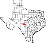
Kimble County, Texas Basics:


Kimble County Texas - Government Site

Population: 4,547
Area: 1251 square miles
County seat: Junction
Area code(s) in use: 325
Time zone: CST
High school graduate or higher: 81.2%
Bachelor's degree or higher: 17.9%
Median household income: $46,786
Persons in poverty: 15.8%
Home ownership rate: 72.7%
Mean travel time to work: 15.6 minutes


Adjacent counties:
Edwards  Gillespie  Kerr  Mason  Menard  Schleicher  Sutton  

Find in Texas

Map of the Kimble County area


Our detail map of Kimble County shows the Kimble County, Texas boundary lines and other interesting items.

Places in Kimble County, Texas

  Airports     show all on map

F-6 Ranch Air Field, J R Ranch Airport, Kimble County Airport, Robinson Ranch Airport

  Bridges     show all on map

State Highway 27 Bridge, State Highway 27 Bridge

  Buildings     show all on map

Brambletye House, Junction Volunteer Fire Department, Kimble County Courthouse, Kimble County Emergency Medical Services, Kimble County Jail, Kimble County Library, Kimble Historical Museum

  Cemeteries     show all on map

Bannowsky Cemetery, Bear Creek Cemetery, Big Paint Creek Cemetery, Cedar Hill Cemetery, Gentry Creek Cemetery, London Cemetery, Noxville Cemetery, Red Creek Cemetery, Schrier Cemetery, Sunset Cemetery, Woaten Cemetery

  Churches     show all on map

Church of Christ, First Baptist Church, Goodwill Baptist Church, Hill Country Baptist Church, Ivy Chapel, Murr Church, Northside Church of Christ, Sunset Church, Trinity Episcopal Church

  Cliffs     show all on map

Cloud Point, Lovers Leap, Sanders Bluff, White Bluff

  Dams     show all on map

Lake Junction Dam, Moody Lake Dam, Paint Creek Ranch Lake Dam

  Falls     show all on map

The Falls

  Gaps     show all on map

Cedar Gap, Mexican Gap, Reichenau Gap

  Hospitals     show all on map

Kimble County District Hospital

  Locales     show all on map

A Murr Ranch, Back Pasture Windmill, Baker Ranch, Baldy Windmill, Bierschwale Windmill, Big West Windmill, Bolt Ranch, Bruns Ranch, Bur Oak Windmill, Daisy Windmill, Dicks Hollow Windmill, Dutton Ranch, East Windmill, Eclipse Windmill, Falls Prong Windmill, Field Windmill, Gerhart Ranch, Graham Ranch, Hill Ranch, Hilltop Windmill, Holland Ranch, Holland Ranch, Johnston Ranch, Lopez Ranch, Mansfield Ranch, Maynard Ranch, New Windmill, North Trap Windmill, North Williams Windmill, North Windmill, North Windmill, Old Noxville, Other Windmill, Paint Creek Ranch, Ridenhower Ranch, Rocky Ridge Ranch, Rose Ranch, Rust Ranch, Rusty Windmill, South Trap Windmill, South Williams Windmill, South Windmill, Spiller Ranch, Tecaboca Camp, Trails End Ranch, Triple Tanks Windmill, West Windmill, West Windmill, Windmill Number Two

  Parks     show all on map

Schreiner Park, Schrier Park, South Llano River State Park, Walter Buck Wildlife Management Area

  Populated Places     show all on map

Bear Creek Settlement (historical), Buck Hollow, Cleo, Junction, Kimbleville (historical), London, Noxville, Roosevelt, Segovia, Telegraph, Wilson Place, Yates

  Post Offices     show all on map

Junction Post Office, London Post Office, Roosevelt Post Office, Telegraph Post Office

  Reservoirs     show all on map

Cedar Lake, Kimble County WCID Lake, Lake Junction, Moody Lake, Paint Creek Ranch Lake, Roach Lake, White Oak Creek Reservoir

  Ridges     show all on map

Patterson Ridge

  Schools     show all on map

Junction Elementary School, Junction High School, Junction Middle School, Texas Technical University Center

  Springs     show all on map

Bur Oak Spring, Burnt Branch Spring, Cave Hollow Spring, Chimney Hollow Spring, Christmas Canyon Spring, Coleman Springs, Cracked Spring, East Spring, Elm Spring, Flat Rock Spring, Gentry Springs, Gorman Spring, Headquarters Springs, Hollow Pasture Spring, Iona Springs, James River Spring, Old Ranch Spring, Parker Spring, Rock Springs, Scott Springs, Shin Oak Spring, South Pasture Spring, The Big Springs, Tobe Spring, Trough Spring, Walker Spring, Walton Spring, West Spring

  Streams     show all on map

Bailey Creek, Bear Creek, Big Hog Creek, Big Saline Creek, Bois d'Arc Creek, Bowie Creek, Burnt Branch, Byas Branch, Cajac Creek, Calf Creek, Cedar Branch, Cedar Creek, Cedar Creek, Cedar Hollow Creek, Chalk Creek, Contrary Creek, Copperas Creek, Dry Cedar Creek, East Prong Calf Creek, East Sycamore Creek, Elm Slough, Falls Creek, Falls Prong, Fessenden Branch, Frog Creek, Gentry Creek, Grays Branch, Hog Creek, Indian Branch, Johnson Fork, Joy Creek, Joy Creek, Little Devils River, Little Hog Creek, Little Paint Creek, Little Saline Creek, Maynard Creek, Middle Copperas Creek, Middle Sycamore Creek, Nixon Creek, North Creek, North Llano River, Paint Creek, Potter Creek, Ratliff Creek, Red Creek, Salina Creek, Salty Creek, Salty Creek, Shin Oak Creek, South Llano River, South Saline Creek, Spring Creek, Stark Creek, Sycamore Creek, Sycamore Creek, The Bogs, Tobe Branch, West Bear Creek, West Dry Branch, West Fork Maynard Creek, West Prong Calf Creek, West Sycamore Creek, White Oak Creek

  Summits     show all on map

Allison Mountain, Black Mountain, Cedar Knob, Joes Point, Round Top, Steamboat Mountain, Teacup Mountain

  Towers     show all on map

KLFO-FM (Junction), KMBL-AM (Junction)

  Trails     show all on map

South Llano River State Park Trail, Walter Buck Wildlife Management Area Trail

  Valleys     show all on map

Allison Draw, Bear Hollow, Bear Hollow, Bee Cave Hollow, Bell Hollow, Big Draw, Brewer Hollow, Buck Hollow, Buck Spring Hollow, Bur Oak Draw, Cedar Hollow, Cedar Hollow, Chimney Hollow, Christmas Hollow, Coon Hollow, Cougar Hollow, Crisp Hollow, Deep Hollow, Dry Hollow, Earwood Draw, East Prong Indian Hollow, Edwards Draw, Eli Hollow, Elm Hollow, Fleming Draw, Ford Canyon, Fox Hollow, Frog Springs Draw, Gilliam Draw, Gorman Draw, Holden Hollow, House Hollow, Indian Hollow, Jim Little Draw, Johnson Hollow, Kits Hollow, Kountz Draw, Levels Hollow, Long Hollow, Monroe Hollow, Mudge Draw, Ox Hollow, Pole Hollow, Rabbit Hollow, Rattlesnake Draw, Reick Draw, Rock House Hollow, Rock Springs Hollow, Rough Hollow, Snake Draw, Spring Hollow, Stewart Gulch, Stroope Canyon, Telegraph Canyon, Turkey Draw, Turkey Draw, Turkey Hollow, Turkey Hollow, Wagon Bed Draw, Walnut Canyon, Walton Draw, Walton Draw, West Draw, Wolf Draw, Wood Hollow,

Kimble County, Texas Population By Race (2012 estimate)

RacePopulation
WhiteKimble County White population 4,4154,415  
American IndianKimble County American Indian population 5050
AsianKimble County Asian population 3636
BlackKimble County Black population 2322
MixedKimble County Mixed population 1818
Hawaiian & Pacific IslanderKimble County Hawaiian & Pacific Islander population 54

Additional population tables :
State population table
Texas population by county