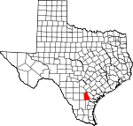
Live Oak County, Texas Basics:
Live Oak County Texas - Government Site
Population: 11,669
Area: 1040 square miles
County seat: George West
Area code(s) in use: 361 830
Time zone: CST
High school graduate or higher: 79.0%
Bachelor's degree or higher: 13.1%
Median household income: $42,182
Persons in poverty: 15.9%
Home ownership rate: 80.4%
Mean travel time to work: 23.8 minutes
Adjacent counties:
Atascosa Bee Duval Jim Wells Karnes McMullen San Patricio
Places in Live Oak County, Texas
Arrowhead Airport,
Beefmasters Best Airport,
Live Oak County Airport,
Los Ebanos Ranch Airport,
Rossler Ranch Airport Cactus Park Musueum,
Federal Correctional Institution Three Rivers Facility,
George West Fire Department,
George West Police Department,
Grace Armantrout Museum,
Lagarto Volunteer Fire Department, Live Oak County Branch Library,
Live Oak County Jail, Live Oak County Library,
Live Oak County Sheriff's Office,
Live Oak County Station 1,
Swinney Switch Volunteer Fire Department,
Three Rivers Volunteer Fire Department Pernitas Point Balania Cemetery,
Clegg Cemetery,
Gussettville Cemetery,
Lagarto Cemetery,
Latham Cemetery,
Lebanon Cemetery,
Nell Cemetery,
Old Gussettville Cemetery,
Ray Point Cemetery,
Saint George Cemetery,
Simmons Cemetery,
Wright Cemetery Good Hope Church Millers Bluff Alamo Tank Dam,
Arnold Lake Dam,
Esse Lake Number 7 Dam,
Esse Lake Number 8 Dam,
Harris Dam,
House Lake Dam,
James Esse Lake Dam,
Katzfey Lake Dam,
Lagarto Trib Dam,
Lillian Esse Lake Dam,
Raschke Lake Dam,
Susquehanna Western Lake Dam,
Taylor Lake Number 1 Dam,
Taylor Lake Number 2 Dam,
Taylor Lake Number 3 Dam,
Three Rivers Dam Lake Comanche,
Long Lake,
Sinclair Lake,
Yarbrough Lake Anna Rose,
Aqua Sola Windmill,
Aqua Verde Windmill,
Benada Windmill,
Brushy Windmill,
Cara Windmill,
Clegg Ranch,
Clegg Windmill,
Crystal Windmill,
Debisadero Windmill,
Fort Ramirez Ruins,
Fuste Windmill,
Garza Ranch,
House Windmill,
Huisache Windmill,
Iley Ranch,
Jaboncillo Windmill,
Jack West Windmill,
Jacobs Windmill,
Javelina Windmill,
Lease Windmill,
Lyne Ranch,
Mala Suerte Windmill,
Morris Windmill,
Muerto Windmill,
Mulos Hills Ranch,
Oil Well Windmill,
Old Turkey Windmill,
Preza Windmill,
Rincon Windmill,
Salt Well Windmill,
Suniland,
Swinney Switch,
The Tubs Windmill,
Twin Oaks Ranch,
Walter Windmill,
Zephyr Encampment Burnett Oil and Gas Field,
Christensen Oil Field,
Clay West Oil Field,
Clayton Oil Field,
Coquat Gas Field,
Ezzell River Oil Field,
Hall Ranch Oil Field,
Harris Oil Field,
Hinnant Oil Field,
Hinnant Oil Field,
Karon Gas Field,
Karon South Oil Field,
Maxine East Oil Field,
Maxine Oil Field,
McNeil Oil Field,
McNeil South Oil Field,
Oakville Gas Field,
Oakville-Wilcox Gas Field,
Piasano Oil Field,
Ramirena Oil Field,
West George West Oil Field James E Daughtrey Wildlife Management Area,
Tips Park Argenta,
Clegg,
Dinero,
Esseville,
George West, Gussett (historical),
Hideaway Hill,
Ike,
Karon,
La Para,
Lagarto,
Los Lomas,
Mikeska,
Mount Lucas,
Nell,
Oakville, Paesta (historical),
Peace Valley Harbor,
Ray Point,
River Creek Acres,
Simmons,
Three Rivers,
Whitsett George West Post Office,
Three Rivers Post Office,
Whitsett Post Office Mulos Hills Agarita Tank,
Alamo Tank,
Alamo Tank,
Arnold Lake,
Bass Tank,
Caliche Tank,
Dino Tank,
Dumont Tank,
Esse Lake Number 7,
Esse Lake Number 8,
Harris Lake,
House Lake,
Huisache Tank,
Jacobs Tank,
James Esse Lake,
Javelina Tank,
Katzfey Lake,
Lake Corpus Christi,
Lillian Esse Lake,
Palo Blanco Tank,
Raschke Lake,
Sulphur Tank,
Susquehanna Western Lake,
Taylor Lake Number 1,
Taylor Lake Number 2,
Taylor Lake Number 3,
Three Rivers Lake,
Twin Tanks,
Willow Hollow Tank Buck Ridge,
Crater Ridge George West Elementary School, George West High School,
George West High School,
George West Junior High School,
George West Primary School, Three Rivers Alternative Campus, Three Rivers Elementary School, Three Rivers High School, Three Rivers Middle School
McGloin Water Hole Spring (historical), Oakville Springs (historical), Ojo de Agua Ramirena Spring (historical), San Christoval Springs
Atascosa River,
Best Branch,
Charquitas Creek,
Comanche Branch,
East Fork Salt Creek,
Elm Creek,
Frio River,
Gilden Creek,
Hackberry Creek,
Hackberry Creek,
Hot Well Creek,
La Para Creek,
Lagarto Creek,
Lang Creek,
Leopard Branch,
Leopard Creek,
Little Creek,
Live Oak Creek,
Longoria Creek,
McKimzey Creek,
Mustang Creek,
Mustang Creek,
Olds Slough,
Olmos Creek,
Paisano Creek,
Paisano Creek,
Ramirena Creek,
Rex Cabaniss Creek,
Rock Quarry Branch,
Salt Branch,
Salt Branch,
Salt Branch,
Salt Branch,
Salt Branch Ramirena Creek,
Salt Creek,
South Fork Salt Branch,
Spring Creek,
Sulphur Creek,
Tepecate Creek,
Timon Creek,
Weedy Creek,
West Weedy Creek,
White Creek Balania Hill,
Carmel Hills,
Comanche Hills,
Odom Hill KYTX-FM (Beeville) Beldon Hollow,
Brush Pen Hollow,
Charley York Hollow,
Dix Hollow,
Friday Hollow,
Gamble Gully,
Garcia Hollow,
Gerhard Hollow,
Graveyard Hollow,
Hailey Hollow,
Hog Hollow,
Lavena Hollow,
Little Gamble Gully,
Live Oak Hollow,
Long Hollow,
McCoy Hollow,
Merriman Hollow,
Mustang Hollow,
Odom Hollow,
Opossum Hollow,
Prairie Hollow,
Ramie Hollow,
Rufe Williams Hollow,
Sand Hollow,
Scuffle Hollow,
Sinclair Hollow,
Smith Hollow,
Ursher Hollow,
Vatoss Gully,
Waller Gully,
Weathersby Hollow,
Willow Hollow Coma Well,
Green Pump Well,
New Well,
Salt Well,

