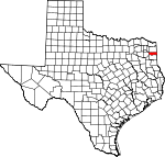
Marion County, Texas Basics:


Marion County Texas - Government Site

Population: 10,320
Area: 381 square miles
County seat: Jefferson
Area code(s) in use: 903
Time zone: CST
High school graduate or higher: 80.2%
Bachelor's degree or higher: 10.9%
Median household income: $32,226
Persons in poverty: 21.9%
Home ownership rate: 75.2%
Mean travel time to work: 27.4 minutes


Adjacent counties:
Caddo (LA)  Camp  Cass  Harrison  Morris  Upshur  

Find in Texas

Map of the Marion County area


Our detail map of Marion County shows the Marion County, Texas boundary lines and other interesting items.

Places in Marion County, Texas

  Airports     show all on map

Cypress River Airport, Manning Field Airport, Mc Kenzie Field Airport

  Areas     show all on map

Lake Ferrell Oil Field

  Basins     show all on map

Ames Spring Basin

  Buildings     show all on map

Alley-Carlson House, Beard House, Captain William E Singleton House, Captain William Perry House, Epperson-McNutt House, Excelsior Hotel, Freeman Plantation, Freeman Plantation House, Gray Volunteer Fire Department, Hodge-Taylor House, House of the Seasons Museum, Jackson Volunteer Fire Department, Jefferson Carnegie Library, Jefferson Historical Museum, Jefferson Independent School District Police Department, Jefferson Playhouse, Jefferson Police Department, Jefferson Volunteer Fire Department, Magnolias house, Marion County Constable's Office Precinct 1, Marion County Constable's Office Precinct 2, Marion County Jail, Marion County Sheriff's Office, Mims Volunteer Fire Department and Ambulance Service, Old United States Post Office and Courts Building, Perry M Woods House, Presbyterian Manse, Sedberry House, Smithland Volunteer Fire Department, South Shore Volunteer Fire Department, Texas Heritage Library, Texas History Museum

  Canals     show all on map

Clinton Ditch

  Cemeteries     show all on map

Beamer - Davis Cemetery, Brantly Cemetery, Burks-Hart Cemetery, Cedar Grove Cemetery, Cedar Grove Cemetery, Core Cemetery, Core Cemetery, Douglas Cemetery, Gray Cemetery, Judea Cemetery, Lockett Cemetery, Macedonia Cemetery, Meadows Cemetery, Monterey Cemetery, Moseley Cemetery, Mount Sinai Cemetery, Oakwood Cemetery, Old Foundry Cemetery, Pyland Cemetery, Rand Cemetery, Simmons Cemetery, Valley Plains Cemetery, Webb Cemetery, Whatley Cemetery

  Census     show all on map

Pine Harbor Census Designated Place

  Channels     show all on map

Lone Pine Stretch

  Churches     show all on map

Adams Chapel, Belview Church, Bethel Church, Bethlehem Church, Christ Episcopal Church, Church of the Nazarene, Conners Chapel, Corinth Church, Cypress Chapel, Douglas Chapel, First Baptist Church, Immaculate Conception Church, Judea Church, Lewis Chapel, Liberty Church, Lodwick Church, Logan Chapel, Lone Oak Church, Mims Chapel, Moores Chapel, Morning Star Church, Mount Carmel Church, Mount Maria Church, Mount Olive Church, Mount Pilgrim Church, Mount Pleasant Church, New Zion Church, Savannah Church, Shady Grove Church, Shady Grove Church, Sunview Church, Trinity Church, Union Church, Union Church

  Cliffs     show all on map

Annie Glade Bluff, Pine Bluff, Potters Point

  Dams     show all on map

Felix A Smith Lake Dam, Ferrells Bridge Dam, Johnson Creek Dam, Lone Star Steel Lake Dam

  Guts     show all on map

Blind Slough, Britts Gap, Carters Chute, Gravier Slough, Jenkins Slough, Old House Slough, Patterson Slough, Perch Gap, Smiths Slough, Whangdoodle Pass, Whistleberry Slough

  Islands     show all on map

Big Green Break, Goat Island, Horse Island, Watts Island

  Lakes     show all on map

Back Lake, Carter Lake, Clinton Lake, Dixon Pond, Monterey Lake, Stratford Lake

  Locales     show all on map

Brushy Creek Campground, East Abutment Recreation Area, Jackson Community Building, Jefferson Historic District, Kellyville Siding, Pine Hill Picnic Ground, Pops Landing Campground, Robertson Boys Camp, Warners Landing Campgrounds, Wilkes Powerplant

  Oilfields     show all on map

Lassater Gas Field, Potter Oil Field, Rodessa Oil Field, Vickie Lynn Oil Field, Vivian Oil Field

  Parks     show all on map

Alley Creek Park, Alley Creek Recreation Area, Buckhorn Creek Park, Caddo Lake Wildlife Management Area, Copeland Creek Recreation Area, Hurricane Creek Recreation Area, Johnson Creek Recreation Area, Lakeside Park, Oak Valley Park, West Abutment Recreational Area

  Populated Places     show all on map

Berea, Burford, Gethsemane, Gray, Hall, Jackson, Jefferson, Kellyville, Lassater, Lodi, Macedonia, Mims Chapel, Monterey, Orrs, Payne, Prospect, Rock Island, Rock Springs, Sarber, Smithland, Victory, Warlock, White Oak

  Post Offices     show all on map

Jefferson Post Office, Lodi Post Office

  Reservoirs     show all on map

Caddo Lake, Clear Lake, Felix A Smith Lake, Hope Springs Lake, Johnson Creek Reservoir, Lake By-Heck, Lake O' the Pines, Littletons Lake, Railroad Pond, Sarber Lake, Taylors Lake, Upper Clear Lake

  Schools     show all on map

Central High School, Jefferson Elementary School, Jefferson High School, Jefferson Middle School, Jefferson Rural Academy

  Springs     show all on map

Jefferson Springs (historical), Kelley Springs, Old Foundary Spring, Potter Springs, Rock Springs, Rogers Springs, Sulphur Springs

  Streams     show all on map

Alley Creek, Arms Creek, Big Cypress Bayou, Big Cypress Creek, Black Cypress Bayou, Cattail Creek, Copeland Creek, Frazier Creek, French Creek, Hasty Creek, Hunts Creek, Hurricane Creek, James Bayou, Johnson Creek, Kitchen Creek, Little Creek, Little Cypress Bayou, Maddox Branch, Mill Creek, Mill Creek, Scotts Creek, Smithland Branch, White Oak Creek

  Summits     show all on map

Locks Mountain

  Swamps     show all on map

Hells Half Acre

  Towers     show all on map

KJTX-FM (Jefferson), Mims Chapel Lookout Tower,

Marion County, Texas Population By Race (2012 estimate)

RacePopulation
WhiteMarion County White population 7,6377,636  
BlackMarion County Black population 2,3012,301
MixedMarion County Mixed population 217216
American IndianMarion County American Indian population 103103
AsianMarion County Asian population 5251
Hawaiian & Pacific IslanderMarion County Hawaiian & Pacific Islander population 00

Additional population tables :
State population table
Texas population by county