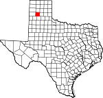
Randall County, Texas Basics:
Randall County Texas - Government Site
Population: 125,022
Area: 912 square miles
County seat: Canyon
Area code(s) in use: 806
Time zone: CST
High school graduate or higher: 91.3%
Bachelor's degree or higher: 29.9%
Median household income: $57,509
Persons in poverty: 9.7%
Home ownership rate: 69.3%
Mean travel time to work: 19.0 minutes
Adjacent counties:
Armstrong Carson Castro Deaf Smith Oldham Potter Swisher
Places in Randall County, Texas
Airsport Skyranch,
Blue Sky Airfield,
Buffalo Airport,
Canam Airport,
Flying K Airport,
Maples Field Airport,
Osage Airpark,
Palo Duro Airport,
River Falls Airport,
Tradewind Airport Judys Arch Devils Kitchen Amarillo Fire Department Station 2,
Amarillo Fire Department Station 3,
Amarillo Fire Department Station 5,
Amarillo Fire Department Station 9,
Amarillo Globe Dream House,
Amarillo Medical Services,
Canyon Fire Department Station 1,
Canyon Fire Department Station 2, Canyon Public Library,
L T Lester House,
Lake Tanglewood Fire Department and Emergency Medical Service,
Panhandle-Plains Historical Museum,
Randall County Correctional Center, Randall County Courthouse (historical),
Randall County Fire and Rescue Station 1,
Randall County Fire and Rescue Station 2, Southwest Branch Library,
Timbercreek Canyon Volunteer Fire Department Wesley Point Dreamland Cemetery,
Llano Cemetery,
Memory Gardens,
Palo Duro Wildorado Cemetery,
Saint Paul Cemetery North Randall Division (historical) Beautiful Savior Lutheran Church,
Bell Avenue Baptist Church,
Christ Covenant Presbyterian Church,
Church of Christ - University,
Church of Christ Olsen Park,
Coulter Road Baptist Church,
Fairview Church,
First Baptist Church of Canyon,
First Temple Assembly of God Church,
Grace Baptist Church,
Highland Baptist Church,
Lamount Drive Baptist Church,
Paramount Baptist Deaf Church,
Presbyterian Church of Canyon,
Prince of Peace Lutheran Church,
Saint Georges Episcopal Church,
Saint Marys Catholic Church,
Saint Paul Lutheran Church,
Seventh Day Adventist Church,
South Georgia Baptist Church,
South Lawn Baptist Church,
South Lawn Church,
Southlawn Assembly of God Church,
Southwest Church of Christ,
Trinity Church,
Trinity United Methodist Church,
United Pentecostal Church of Canyon,
Valleyview Church of the Nazarene Fortress Cliff,
The Palisades Bivins Lake Dam,
Frog Dam,
Lake Tanglewood Dam,
McSpadden Lake Dam,
Palo Duro Club Lake Dam,
Roy Gwyn Ranch Lake Dam,
Stanley Schaeffer Dam,
Tom Gerald Ranch Lake Dam,
Umbarger Dam Little Falls Sunday Flats Northwest Texas Surgery Center McSpadden Lake Black Camp,
Camp Harrington,
Canyon City Club,
Canyon Pumping Station,
Cita Canyon Methodist Camp,
Cita Glen Christian Camp,
Currie Ranch,
Forrester Ranch,
Haney,
Irvin Ranch,
Krahn Ranch,
Llano Cemetery Historic District,
McSpadden Pumping Station,
Nanace Ranch,
Owens Ranch,
Reynolds Ranch,
Smoot Ranch,
Sorelle Ranch,
Stevens Ranch,
Thomas Ranch,
Upshaw Ranch Amarillo Dillas Pro Baseball Field,
Amarillo Trinity Fellowship School Stadium,
Buffalo Lake National Wildlife Refuge,
Buffalo Stadium,
Conner Park,
Mesquite Park,
Palo Duro State Park,
Paramount Park,
South Lawn Park,
Southeast Park,
Southeast Park,
Southwest Park Devils Tombstone Elbow Plateau,
Swan Plateau Canyon, Cita (historical),
Cleta,
Lake Tanglewood,
Ogg,
Palisades,
Timbercreek Canyon,
Umbarger,
Zita Umbarger Post Office Bivins Lake,
Buffalo Lake,
Currie Lake,
Frog Lake,
Lake Tanglewood,
McSpadden Lake,
Palo Duro Club Lake,
Roy Gwyn Ranch Lake,
Stanley Schaeffer Lake,
Tom Gerald Ranch Lake Arden Road Elementary School,
Canyon High School,
Canyon Junior High School,
Crestview Elementary School,
David Crockett Junior High School,
Gene Howe Elementary School,
Highland School,
Lakeview Elementary School,
Lamar School,
Landergrin School,
Nance Ranch - West Texas State University,
Olsen Park School,
Oscar Hinger Elementary School,
Paramount Terrace School,
Randall High School,
Rex Reeves Elementary School,
Saint Josephs School,
South Lawn School,
Sundown Lane Elementary School,
Valleyview Junior High School,
West Texas State College, Westover Park Intermediate School,
Youth Center of High Plains Carruth Springs (historical), CCC Springs, Dean Springs (historical), Little Sunday Spring, Long Springs (historical), North Cita Springs (historical), South Cita Springs, T-Anchor Springs (historical), Thompson Springs (historical),
Tub Springs Dry Creek,
Hackberry Creek,
Little Sunday Creek,
North Cita Creek,
Palo Duro Creek,
South Cita Creek,
Spring Branch,
Sunday Creek,
Tierra Blanca Creek,
Timber Creek,
West Fork Prairie Dog Town Fork Red River Brushy Butte,
Capitol Mesa,
Capitol Peak,
Castle Peak,
Cooley Butte,
Goodnight Peak,
Lighthouse Peak,
Red Mesa,
Timber Mesa KAKS-AM (Canyon),
KIXZ-AM (Amarillo),
KLMN-FM (Amarillo),
KPUR-AM (Amarillo),
KPUR-FM (Canyon),
KWTS-FM (Canyon) Buffalo Lake National Wildlife Refuge Trail, Lighthouse Trail
Blue Spring Draw,
Brushy Draw,
Bull Draw,
Burnt Draw,
Capitol Peak Canyon,
Cedar Way Draw,
Chalk Hollow,
Cooley Draw,
Corral Draw,
Curry Draw,
Deep Canyon,
Dugout Draw,
Flat Canyon,
Forked Draw,
Little Draw,
Long Draw,
Nameless Draw,
Negro Arroyo,
North Cita Canyon,
North Spur Valley,
Pin Draw,
Post Draw,
Red Canyon,
Rustlers Draw,
Seep Canyon,
South Brushy Draw,
South Cita Canyon,
Spring Draw,
Stub Draw,
Thomas Draw,
Windmill Draw,
Woody Draw,

