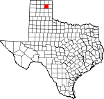
Roberts County, Texas Basics:
Roberts County Texas - Government Site
Population: 852
Area: 924 square miles
County seat: Miami
Area code(s) in use: 806
Time zone: CST
High school graduate or higher: 94.0%
Bachelor's degree or higher: 36.8%
Median household income: $64,688
Persons in poverty: 7.6%
Home ownership rate: 84.4%
Mean travel time to work: 16.2 minutes
Adjacent counties:
Carson Gray Hansford Hemphill Hutchinson Lipscomb Ochiltree Wheeler
Places in Roberts County, Texas
Mesa Vista Ranch Airport,
Miami-Roberts County Airport,
Willis N Clark Airport Miami Roberts County Volunteer Fire Department,
Miami Roberts County Volunteer Fire Department Station 2,
Miami Volunteer Emergency Medical Service, Roberts County Library,
Roberts County Museum Gill Lake Dam,
Jim Waterfield Lake Dam,
Locke Brothers Ranch Lake Dam,
McMordie Lake Dam,
Morrison, Scott and Conrad Lake Number 2 Dam Brainard Ranch,
Cake House Windmill,
East Tallahone Windmill,
Five Tub Windmill,
Hayhook Ranch,
Highland Windmill,
Lake Theis Windmill,
Morrison Ranch,
Morrison Ranch,
New Windmill,
North Camp Windmill,
Pats Creek Camp,
Point Windmill,
Red Windmill,
Sand Hill Windmill,
Sandy Windmill,
Southeast Windmill,
Tree Windmill,
Wayside Community Center Quinpono Gas and Oil Field Codman,
Lora,
Miami,
Parnell (historical),
Wayside Miami Post Office Gill Lake,
Jim Waterfield Lake,
Locke Brothers Ranch Lake,
McMordie Lake,
Morrison, Scott and Conrad Lake Number 2 Miami School Chicken Springs, Cunningham Springs,
Garden Springs, Garden Springs,
Henry Spring, Henry Springs, Home Ranch Springs (historical), Nickels Springs, Polecat Springs, Tallahone Springs, Three Corrals Springs (historical),
Waterfield Springs,
Whitsell Springs Barton Creek,
Bluff Creek,
Cat Creek,
Chicken Creek,
Dry Creek,
Dugout Creek,
East Dry Creek,
East Fork Pats Creek,
Hackberry Creek,
Home Ranch Creek,
Horse Creek,
Indian Creek,
Jocks Creek,
Johns Creek,
Northwest Fork Point Creek,
Pats Creek,
Pickett Ranch Creek,
Picketts Ranch Creek,
Point Creek,
Reynolds Creek,
Sourdough Creek,
Tallahone Creek,
Three Corrals Creek,
West Dugout Creek,
West Fork Reynolds Creek,
Willow Creek Tandy Mesa Government Canyon,

