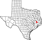
San Jacinto County, Texas Basics:
San Jacinto County Texas - Government Site
Population: 27,083
Area: 569 square miles
County seat: Coldspring
Area code(s) in use: 936
Time zone: CST
High school graduate or higher: 79.4%
Bachelor's degree or higher: 11.8%
Median household income: $46,413
Persons in poverty: 17.6%
Home ownership rate: 83.2%
Mean travel time to work: 40.0 minutes
Adjacent counties:
Liberty Montgomery Polk Trinity Walker
Places in San Jacinto County, Texas
Lake Bay Gall Airport,
Lake Water Wheel Airport Logan League Grama Grass Bottom 980 North Volunteer Fire Department,
Bear Creek Volunteer Fire Department,
Camilla Volunteer Fire Department,
Cold Spring - Oakhurst County Independent School District Police Department, Coldspring Area Public Library,
Coldspring Volunteer Fire Department,
Coldspring Volunteer Fire Department Substation,
Legacy Emergency Medical Services,
Legacy Emergency Medical Services,
Legacy Emergency Medical Services,
Oakhurst Volunteer Fire Department,
Point Blank Volunteer Fire Department,
Punkin - Evergreen Volunteer Fire Department,
San Jacinto County Constable's Office Precinct 1,
San Jacinto County Constable's Office Precinct 2,
San Jacinto County Constable's Office Precinct 3,
San Jacinto County Constable's Office Precinct 4,
San Jacinto County Jail,
San Jacinto County Sheriff's Office,
San Jacinto Old Jail Museum, Shepherd Public Library,
Shepherd Volunteer Fire Department,
Waterwood Volunteer Fire Department Big Creek Cemetery,
Butler Cemetery,
Carter Cemetery,
Center Hill Cemetery,
Cochran Cemetery,
Coley Creek Cemetery,
Community Relief Cemetery,
Ellis Cemetery,
Evergreen Cemetery,
Farley Cemetery,
Hargrove Cemetery,
Harrell Cemetery,
Hoby Cemetery,
Jenkins Cemetery,
Lake Station Cemetery,
Laurel Hill Cemetery,
Lewis Cemetery,
Liberty Hill Cemetery,
Lovett Cemetery,
McGown Cemetery,
Milby Hill Cemetery,
Mitchell Cemetery,
Mount Capers Cemetery,
Mount Zion Cemetery,
Purkerson Cemetery,
Roark Cemetery,
Robinson Cemetery,
Rose Hill Cemetery,
Scott Cemetery,
Spring Hill Cemetery,
Squier Cemetery,
Williams Cemetery,
Youngblood Cemetery Cape Royale Census Designated Place,
Oakhurst Census Designated Place Big Creek Missionary Church,
Calvary Church,
Center Hill Church,
China Grove Church,
County Line Church,
Darby Hill Church,
Enterprise Church,
Farley Chapel,
Hoby Church,
Hopewell Church,
Lake Pool Church,
Lake Station Church,
Laurel Hill Church,
Magnolia Church,
Magnolia Grove Church,
Maple Hill Church,
Montague Church,
Mount Mariah Church,
Mount Pilgrim Church,
New Hope Church,
New Hope Church,
Old Waverly Church,
Paul Horton Memorial Church,
Pine Grove Missionary Church,
Pine Valley Church,
Pine Valley Church,
Pleasant Grove Church,
Pleasant Grove Church,
Pleasant Grove Missionary Church,
Salem Church,
Snow Hill Church,
Spring Hill Church,
Spring Ridge Church,
Sweet Home Church,
White Hill Missionary Church Sulphur Bluffs A and W Ranch Lake Dam,
Andrews Lake Dam,
Double Lake Dam,
Howard Lake Dam,
Lake Run-A-Muck Dam,
Lake Tejas Dam,
Livingston Dam,
Water Wheels Lake Number 1 Dam,
Water Wheels Lake Number 2 Dam,
Williams Lake Dam,
Woodlands Golf Course Lake Dam Sam Houston National Forest Blue Lake,
Brushy Lake,
Chapman Ponds,
Gator Pond,
Henry Lake,
Lost Lake,
Smith Break,
Stock Pen Lake,
Wood Lake,
Woods Lake Big Woods Hunter Camp,
Double Lake Campground,
Liberty Hill Lookout,
Lone Star Trail Primitive Camp Number One,
Lone Star Trail Primitive Camp Number Two,
Nebletts Hunter Camp,
Palmetto Park,
San Jacipto Work Center,
Shell Hunter Camp,
Tarkington Hunter Camp,
Willow Springs Lookout Coldspring Oil Field,
Coline Oil Field,
Mercy Oil Field Big Creek Scenic Area,
Coldspring Memorial Park,
Double Lake Recreation Area,
Palmetto Park,
Raven Hill Historical Monument,
Wolf Creek Park Bear Creek,
Camilla,
Coldspring,
Darby Hill,
Drews Landing,
Evergreen,
Lake Tejas,
Lake Water Wheel,
Laurel Hill,
Liberty Hill,
Magnolia,
Maynard,
Napier,
Oak Grove,
Oakhurst,
Old Waverly,
Palmetto Park,
Pointblank,
Pumpkin, Quail Creek,
Rose Hill,
Shepherd,
Snow Hill,
Spring Hill,
Staley,
Stephen Creek,
Strington,
Urbana,
Waterwood,
Waverly,
Westcott,
Willow Springs,
Wolf Creek, Wonderland Forest
Coldspring Post Office,
Oakhurst Post Office,
Pointblank Post Office,
Shepherd Post Office A and W Ranch Lake,
Andrews Lake,
Double Lake,
Evans Lake,
Howard Lake,
Lake Baygall,
Lake Livingston,
Lake Magnolia,
Lake Run-A-Muck,
Lake Tejas,
Letbetter Lake,
Water Wheels Lake Number 1,
Water Wheels Lake Number 2,
Williams Lake,
Woodlands Golf Course Lake Cain Ridge Coldspring - Oakhurst Intermediate School,
Dixon High School, Jones High School, Lincoln Junior High School,
Oakhurst School,
Pointblank School, Shepherd High School,
Shepherd Intermediate School,
Shepherd Middle School, Shepherd Primary School, Street Elementary School
Bethea Springs, Big Springs, Campground Springs, Cold Springs, Durdin Springs,
Gold Springs, Gully Springs, Hale Springs, Harris Springs, Lewis Springs,
Ragley Spring, Ragsdale Springs, Skinner Springs, Trapp Springs, Williamson Springs (historical), Willow Springs
Bear Creek,
Big Spring Creek,
Black Branch,
Black Branch,
Blue Branch,
Boggy Creek,
Boswell Creek,
Bradley Branch,
Brickyard Branch,
Browns Creek,
Brushy Creek,
Burge Branch,
Caney Creek,
Caney Creek,
Cedar Lick Branch,
Chinquapin Creek,
Clear Creek,
Clear Creek,
Coley Creek,
Davison Bayou,
Deans Creek,
Dobbins Creek,
Double Lake Branch,
Dry Cherry Creek,
Dry Huffman Creek,
East Carolina Creek,
East Fork Caney Creek,
East Fork Pumpkin Creek,
Fish Branch,
Gum Branch,
Henry Lake Branch,
Hickman Branch,
Hopkins Branch,
Huffman Creek,
Indian Creek,
Jayhawker Creek,
Johnson Creek,
Kickapoo Creek,
Little Caney Creek,
Little Creek,
McCombs Creek,
McCombs Creek,
McGee Creek,
Mill Branch,
Mill Creek,
Mill Creek,
Miller Creek,
Morris Creek,
Mussel Shoals,
Nebletts Creek,
Negro Creek,
Newton Branch,
Oil Creek,
Palmetto Creek,
Pools Creek,
Pumpkin Creek,
Reese Branch,
Rocky Branch,
Rocky Creek,
Rocky Creek,
Rocky Creek,
Rocky Creek,
Ross Branch,
Sand Creek,
Shoemake Creek,
Spring Branch,
Stephen Creek,
Sulphur Branch,
Turkey Creek,
West Fork Caney Creek,
West Fork Pumpkin Creek,
Wheatfield Branch,
Williams Creek,
Winters Bayou,
Wolf Creek,
Yates Creek,
Zwickey Creek Camp Hill,
Darby Hill,
Liberty Hill,
Rocky Hill Horse Marsh,
The Break KJZS-FM (Conroe),

