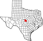
San Saba County, Texas Basics:


San Saba County Texas - Government Site

Population: 6,016
Area: 1135 square miles
County seat: San Saba
Area code(s) in use: 325
Time zone: CST
High school graduate or higher: 82.1%
Bachelor's degree or higher: 17.2%
Median household income: $37,230
Persons in poverty: 19.1%
Home ownership rate: 79.7%
Mean travel time to work: 21.7 minutes


Adjacent counties:
Brown  Burnet  Lampasas  Llano  Mason  McCulloch  Mills  

Find in Texas

Map of the San Saba County area


Our detail map of San Saba County shows the San Saba County, Texas boundary lines and other interesting items.

Places in San Saba County, Texas

  Airports     show all on map

Deep Creek Ranch Airport, San Saba County Municipal Airport, Yates Field Airport

  Areas     show all on map

Lost Section

  Basins     show all on map

Cedar Hollow, Turkey Valley

  Bends     show all on map

Horseshoe Bend, Horseshoe Bend, Shaw Bend

  Buildings     show all on map

Cherokee Volunteer Fire Department, Richland Springs Volunteer Fire Department, Rylander Memorial Library, San Saba County Courthouse, San Saba County Emergency Medical Service, San Saba County Historical Museum, San Saba County Jail, San Saba Volunteer Fire Department, Texas Department of Criminal Justice Region 6 San Saba Transfer Facility, Texas Rehabilitation Center

  Cemeteries     show all on map

Adams Cemetery, Bowser Cemetery, Brown Cemetery, Catclaw Cemetery, China Creek Cemetery, Crawford Cemetery, Davidson Cemetery, Deer Creek Cemetery, Ellis Cemetery, Elmwood Memorial Park, Estep Cemetery, Farr Cemetery, Gray Cemetery, Hanna Cemetery, Harmony Ridge Cemetery, Harris Cemetery, Holt Cemetery, Kuykendall Cemetery, Linn Cemetery, Little Elm Cemetery, Locker Cemetery, McCarty Cemetery, McMillin Cemetery, Mesquite Cemetery, Montgomery Cemetery, Neal Cemetery, Old Algerita Cemetery, Richland Springs Cemetery, Rough Creek Cemetery, San Saba City Cemetery, Shaw Bend Cemetery, Shiloh Cemetery, Spring Creek Cemetery, Terry Cemetery, Vargy Chapel Cemetery, Wallace Creek Cemetery

  Churches     show all on map

Colony Church, Crescent Heights Baptist Church, Crescent Heights Church, Elm Grove Church, Elmwood Church, First Baptist Church, First Presbyterian Church, Grace Church, Grace Lutheran Church, Holt Church, New Hope Church, Pecan Grove Church, Rock Shoals Cumberland Church, Rough Creek Church, Saint Marys Catholic Church, Saint Southwest Park Church, Shiloh Church, Southwest Park Baptist Church, Union Band Church, United Pentecostal Church

  Cliffs     show all on map

Chimney Bluff, Indian Point, Raven Bluff, Red Bluff

  Dams     show all on map

Childress Lake Dam, Deep Creek Ranch Lake Dam, Dyer Lake Dam, Lake Margery Dam, McDaniel Lake Dam, Miller Dam, Ratliff Lake Dam, Renfro Dam, Sofge-Bates Lake Number 1 Dam, Sofge-Bates Lake Number 2 Dam, Soil Conservation Service Site 1 Dam, Soil Conservation Service Site 10 Dam, Soil Conservation Service Site 10 Dam, Soil Conservation Service Site 11 Dam, Soil Conservation Service Site 12 Dam, Soil Conservation Service Site 13a Dam, Soil Conservation Service Site 14a Dam, Soil Conservation Service Site 15 Dam, Soil Conservation Service Site 16 Dam, Soil Conservation Service Site 2 Dam, Soil Conservation Service Site 2 Dam, Soil Conservation Service Site 3 Dam, Soil Conservation Service Site 3 Dam, Soil Conservation Service Site 4 Dam, Soil Conservation Service Site 4 Dam, Soil Conservation Service Site 5 Dam, Soil Conservation Service Site 5 Dam, Soil Conservation Service Site 6 Dam, Soil Conservation Service Site 6 Dam, Soil Conservation Service Site 7 Dam, Soil Conservation Service Site 7 Dam, Soil Conservation Service Site 8 Dam, Soil Conservation Service Site 8a-1 Dam, Soil Conservation Service Site 9 Dam, Soil Conservation Service Site 9 Dam, William Harlow Lake Dam, Wilson Lake Dam

  Falls     show all on map

Gorman Falls, Post Oak Falls

  Flats     show all on map

Lick Flat, Potter Flats, York Flat

  Gaps     show all on map

Hog Pass

  Lakes     show all on map

Bear Water Hole, Blackjack Pond, Glory Hole, High Pond, Little Blackjack Pond, Old Pond, Rattlesnake Pond, Woodward Pond

  Locales     show all on map

Barnes Ranch, Bear Hollow Windmill, Behmes Windmill, Big Windmill, Blackgate Windmill, Blue Sox Sadium, Bull Trap Windmill, Bush Windmill, Camp Billy Gibbons, Campbell Ranch, Camphouse Windmill, Dofflemyer Windmill, East Murray Windmill, Ellis Ranch, Elm Grove Community Center, Flying V Ranch, Flying V Windmill, Hays Windmill, High Lonesome Windmill, High Windmill, High Windmill, Highway Windmill, Indian Hill Windmill, Indian Mound Windmill, Javelina Windmill, Jenkins Windmill, Jones Windmill, Kelley Windmill, Lakeview Community Hall, Lemons Springs Camp, Little Windmill, Martin Lease Windmill, Mesquite Windmill, Middle Pens Windmill, Mining House Windmill, New Windmill, New Windmill, Nine-Bar Ranch, Nored Ranch, North Windmill, North Windmill, Parks Mill, Pole Pen Ranch, Pool Ranch, Robinson Ranch, Sloan Sisters Ranch, Sorrell Ranch, South Windmill, Taylor Ranch, West Windmill

  Parks     show all on map

Colorado Bend State Park, Fair Park, Historical Monument, Indian Stadium, San Saba City Park

  Populated Places     show all on map

Algerita, Bend, Bend, Bolt (historical), Bomar (historical), Bowser, Chappel, Cherokee, China Creek, Elm Grove, Fairview, Hall, Harkeyville, Hicks Crossing, High Valley, Holt, Knobb (historical), Locker, McMillan, Pecan Springs, Red Bluff (historical), Richland Springs, Rough Creek Crossing, San Saba, Skeeterville, Sloan, Spring Creek

  Post Offices     show all on map

Cherokee Post Office, San Saba Post Office

  Reservoirs     show all on map

Barker Tank, Big Sally Tank, Bull Trap Tank, Childress Lake, Click Tank, Deep Creek Ranch Lake, Denison Tank, Dunbar Tank, Dyer Lake, Evans Tank, Flemming Tank, Hubbard Tank, Jim Ned Tank, Lake Margery, Larremore Tank, Little Silly Tank, Lower San Saba Watershed Reservoir, Lower San Saba Watershed Reservoir, Lower San Saba Watershed Reservoir Number 10, Lower San Saba Watershed Reservoir Number 11, Lower San Saba Watershed Reservoir Number 12, Lower San Saba Watershed Reservoir Number 16, McDaniel Lake, Miller Lake, Post Oak Tank, Ratliff Lake, Red Tank, Red Tank, Section Tank, Sofge-Bates Lake Number 1, Sofge-Bates Lake Number 2, Soil Conservation Service Site 1 Reservoir, Soil Conservation Service Site 10 Reservoir, Soil Conservation Service Site 10 Reservoir, Soil Conservation Service Site 11 Reservoir, Soil Conservation Service Site 12 Reservoir, Soil Conservation Service Site 13a Reservoir, Soil Conservation Service Site 14a Reservoir, Soil Conservation Service Site 15 Reservoir, Soil Conservation Service Site 16 Reservoir, Soil Conservation Service Site 2 Reservoir, Soil Conservation Service Site 2 Reservoir, Soil Conservation Service Site 3 Reservoir, Soil Conservation Service Site 3 Reservoir, Soil Conservation Service Site 4 Reservoir, Soil Conservation Service Site 4 Reservoir, Soil Conservation Service Site 5 Reservoir, Soil Conservation Service Site 5 Reservoir, Soil Conservation Service Site 6 Reservoir, Soil Conservation Service Site 6 Reservoir, Soil Conservation Service Site 7 Reservoir, Soil Conservation Service Site 7 Reservoir, Soil Conservation Service Site 8 Reservoir, Soil Conservation Service Site 8a-1 Reservoir, Soil Conservation Service Site 9 Reservoir, Soil Conservation Service Site 9 Reservoir, Southeast Laterals Watershed Number Six, Southeast Laterals Watershed Reservoir Number 1, Southeast Laterals Watershed Reservoir Number 10, Southeast Laterals Watershed Reservoir Number 2, Southeast Laterals Watershed Reservoir Number 3, Southeast Laterals Watershed Reservoir Number 4, Southeast Laterals Watershed Reservoir Number 5, Southeast Laterals Watershed Reservoir Number 7, Southeast Laterals Watershed Reservoir Number 8, Southeast Laterals Watershed Reservoir Number 9, Thousand Dollar Tank, Tripp Tank, Watson-Miller Tank, William Harlow Lake, Wilson Lake

  Ridges     show all on map

Lemons Ridge, Shiloh Mountain Chain, Wolf Ridge

  Schools     show all on map

Bonham School, Cherokee Elementary School, Cherokee High School, Crocket School, Fair Park School, Fannin School, Pleasant Hill School, Richland Springs School, Richland Springs School, San Saba Alternative School, San Saba Elementary School, San Saba High School, San Saba Intermediate School, San Saba Junior High School, Sloan School, Wallace Creek School

  Springs     show all on map

Baker Spring, Barnett Springs, Blue Pool Spring, Boiling Springs, Cold Spring, Deep Creek Spring, Deep Creek Spring, Flemming Spring, Flemming Springs, Gorman Spring, Hall Springs, Hart Springs, Heck Springs, Hext Spring, Jennings Springs, Parker Springs, Pecan Pool Spring, Post Oak Spring, Richland Springs, Sloan Pool Spring, Sulphur Spring, Sycamore Springs, Turkey Roost Springs, Walker Spring, Wallace Springs, Woodward Springs

  Streams     show all on map

Antelope Creek, Barnett Springs Creek, Bee Branch, Bee Cave Creek, Billie Branch, Black Branch, Bluff Creek, Brady Creek, Browns Branch, Buffalo Creek, Burnt Branch, Buzzard Creek, Cat Claw Creek, Cedar Branch, Cherokee Creek, China Creek, Cottonwood Creek, Deep Creek, Deer Creek, Dick Hooten Branch, Dry Creek, Dry Simpson Creek, East Deep Creek, East Fork Dick Hooten Branch, East Goens Creek, Elm Branch, Elm Creek, Fall Creek, Flat Branch, Flatrock Branch, Flemming Springs Branch, Goens Creek, Gorman Creek, Gregg Branch, Gregory Creek, Hickory Creek, Hinton Creek, Hog Creek, Hog Creek, Hogg Branch, Honey Creek, Horse Creek, Horse Creek, Horse Creek, Indian Creek, Jackson Branch, Jennings Creek, Jerrys Branch, Jim John Creek, Kemp Creek, King Creek, Klondike Branch, Lambert Branch, Latham Creek, Limekiln Creek, Little Elm Creek, Long Waterhole Branch, Lost Branch, Lost Creek, Lynch Creek, Marley Creek, McAnelly Creek, McDonald Branch, Merriman Branch, Mesquite Creek, Middle Deep Creek, Middle Prong Horse Creek, Mill Creek, Mountain Creek, North Fork Cherokee Creek, North Goens Creek, North Prong Horse Creek, Panther Creek, Pool Branch, Post Oak Creek, Rabbit Creek, Red Mountain Branch, Richland Springs Creek, Robbins Branch, Rock Lick Branch, Rocky Creek, Rook Creek, Rough Branch, Rough Creek, Salt Branch, Salt Creek, San Saba River, Sand Branch, Simpson Creek, South Prong Horse Creek, Spicewood Creek, Spring Creek, Tie Slide Creek, Traywick Branch, Turkey Creek, Turkey Roost Creek, Waco Creek, Wadsworth Creek, Wallace Creek, West Deep Creek, West Fork Dick Hooten Branch, West Goens Creek, Wilbarger Creek, Wild Boar Creek, Woodward Branch, Yates Branch

  Summits     show all on map

Barnett Hill, Blackjack Hill, Brady Mountain, Brushy Mountain, Buffalo Knob, Bunker Hill, Burger Hill, Buzzard Mountain, Cat Knob, Chapel Hill, Corn Knob, Ellenburger Hills, Fivemile Hill, Fourmile Hill, Harkey Knobs, High Point, High Pond Mountain, Horse Mountain, Indian Hills, Linn Hill, Locker Hill, Marley Peaks, Mauldin Hills, Round Mountain, Round Mountain, Round Mountain, Round Mountain, Sand Rock, Shin Oak Mountain, Wildhorse Mountain

  Towers     show all on map

KBAL-AM (San Saba), KFRJ-FM (San Saba)

  Trails     show all on map

Colorado Bend State Park Trail, Mill Pond Park Trail, River Trail, Spicewood Spings Trail, Windmill Trail

  Valleys     show all on map

Bannister Hollow, Bear Hollow, Big Blackjack Hollow, Brushy Hollow, Cedar Creek, Cedar Hollow, Ceder Hollow, Chamberlain Hollow, Clements Hollow, Cowhorn Hollow, Davis Hollow, Devils Hollow, Fort Hollow, Fox Hollow, Hall Valley, Harky Hollow, Hogg Hollow, Hooten Hollow, Indian Hollow, Lick Hollow, Molasses Hollow, Plum Hollow, Rabbit Hollow, T F Hollow, Whey Hollow, Windmill Hollow

  Woods     show all on map

Woodward Grove,

San Saba County, Texas Population By Race (2012 estimate)

RacePopulation
WhiteSan Saba County White population 5,6375,636  
BlackSan Saba County Black population 211210
MixedSan Saba County Mixed population 7878
American IndianSan Saba County American Indian population 7272
AsianSan Saba County Asian population 1818
Hawaiian & Pacific IslanderSan Saba County Hawaiian & Pacific Islander population 00

Additional population tables :
State population table
Texas population by county