Somervell County, Texas Basics:


Somervell County Texas - Government Site

Population: 8,624
Area: 186 square miles
County seat: Glen Rose
Area code(s) in use: 254
Time zone: CST
High school graduate or higher: 83.8%
Bachelor's degree or higher: 30.3%
Median household income: $51,618
Persons in poverty: 10.3%
Home ownership rate: 72.4%
Mean travel time to work: 27.4 minutes

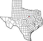
Adjacent counties:
Bosque  Erath  Hood  Johnson  

Find in Texas

Map of the Somervell County area


Our detail map of Somervell County shows the Somervell County, Texas boundary lines and other interesting items.

Places in Somervell County, Texas

  Airports     show all on map

Circle Eight Ranch Airport, Circle P Ranch Airport, Little 'L' Ranch Airport, Running M Ranch Airport, Wright Ranch Airport, Wyatt 3-Rivers Airport

  Bends     show all on map

Mitchell Bend, Turner Bend

  Buildings     show all on map

Barnards Mill, Commanche Peak Nuclear Power Plant Ambulance, Dinosaur Valley State Park, Fossil Rim Wildlife Center, Glen Rose Fire Department, Happy Hill Farm Academy Gymnasium, LifeStar 5 - Southwest Helicopters - Glen Rose, Somervell County Constable's Office Precincts 1 and 2, Somervell County Courthouse, Somervell County Fire Rescue Emergency Medical Services, Somervell County Jail, Somervell County Library, Somervell County Museum, Somervell County Sheriff's Office

  Cemeteries     show all on map

Lanham Mill Cemetery, Nancy Smith Cemetery, Oldham Cemetery, Post Oak Cemetery, Squaw Creek Cemetery, Ward Branch Cemetery

  Churches     show all on map

Chalk Mountain Church, Cottonwood Church, Oden Church, Rock Creek Church, Saint Rose of Lima Catholic Church, White Church

  Dams     show all on map

Arena Lake Dam, Drechsel Lake Dam, McCann Lake Dam, Russell Lake Dam, Safe Shutdown Impoundment Dam, Shipman Dam, Squaw Creek Dam, Twin Arena Lake Dam

  Hospitals     show all on map

Glen Rose Medical Center

  Locales     show all on map

Camp Arrowhead, Camp Tres Rios, Cedar Brake, Glen Lake Camp, Rainbow Camp

  Parks     show all on map

Dinosaur Valley State Park, Happy Hill Farm Academy Baseball Field, Happy Hill Farm Academy Football Field, Tiger Stadium

  Populated Places     show all on map

Chalk Mountain (historical), Cottonwood, Georges Creek, Glass, Glen Rose, Nemo, Rainbow, Rock Creek, Seven Knobs

  Post Offices     show all on map

Glen Rose Post Office, Rainbow Post Office

  Reservoirs     show all on map

Arena Lake, Drechsel Lake, Glen Lake, Lake Reed, McCann Lake, Russell Lake, Safe Shutdown Impoundment, Seals Lake, Shipman Lake, Squaw Creek Reservoir, Twin Arena Lake

  Schools     show all on map

Glen Rose Elementary School, Glen Rose High School, Glen Rose Intermediate School, Glen Rose Junior High School

  Streams     show all on map

Barker Branch, Bowden Branch, Buck Creek, Cross Branch, Denio Branch, Eddy Branch, Georges Creek, Ice Branch, Ice Creek, Million Branch, Montgomery Branch, Opossum Branch, Paluxy River, Panther Branch, Panther Creek, Prairie Creek, Rock Creek, Rough Creek, Rough Creek, Squaw Creek, Taylor Branch, Van Zant Branch, Wheeler Branch, White Bluff Creek

  Trails     show all on map

Cedar Break Trail, Dinosaur Valley State Park Trail

  Valleys     show all on map

Big Kid Hollow, Little Kid Hollow, Opossum Hollow, Wildcat Hollow,

Somervell County, Texas Population By Race (2012 estimate)

RacePopulation
WhiteSomervell County White population 8,1768,175  
MixedSomervell County Mixed population 164163
American IndianSomervell County American Indian population 112112
BlackSomervell County Black population 8686
AsianSomervell County Asian population 6968
Hawaiian & Pacific IslanderSomervell County Hawaiian & Pacific Islander population 98

Additional population tables :
State population table
Texas population by county