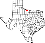
Wichita County, Texas Basics:


Wichita County Texas - Government Site

Population: 131,488
Area: 628 square miles
County seat: Wichita Falls
Area code(s) in use: 940
Time zone: CST
High school graduate or higher: 84.5%
Bachelor's degree or higher: 20.0%
Median household income: $45,589
Persons in poverty: 13.7%
Home ownership rate: 64.3%
Mean travel time to work: 15.8 minutes


Adjacent counties:
Archer  Baylor  Clay  Cotton (OK)  Tillman (OK)  Wilbarger  

Find in Texas

Map of the Wichita County area


Our detail map of Wichita County shows the Wichita County, Texas boundary lines and other interesting items.

Places in Wichita County, Texas

  Airports     show all on map

4-Shipp Airport, Cactus Hill Airport, Kickapoo Downtown Airport, Klinkerman Airport, Lucky G Airport, Mc Alister Farm Airport, Sheppard Air Force Base/Wichita Falls Municipal Airport, Wichita Valley Airport

  Bridges     show all on map

Beaver Creek Bridge

  Buildings     show all on map

Air - Evac Lifeteam 34 Wichita Falls, American Medical Response, Burkburnett Fire Department Station 1, Burkburnett Fire Department Station 3, Burkburnett Library, Cameron Gardens Volunteer Fire Department, Electra Fire Department, Electra Public Library, Friberg - Cooper Fire Department, Grand Theater, Hodges-Hardy-Chambers House, Iowa Park Volunteer Fire Department, Kamay Volunteer Fire and Emergency Medical Services, Kell House Museum, Lake Kickapoo Volunteer Fire Department, Texas Department of Criminal Justice Region 5 James V Allred Unit, Tom Burnett Memorial Library, Trans Star Ambulance, Weeks House, Wichita County Jail, Wichita County Jail Annex Facility, Wichita Falls Fire Department Station 1, Wichita Falls Fire Department Station 2, Wichita Falls Fire Department Station 3, Wichita Falls Fire Department Station 4, Wichita Falls Fire Department Station 5, Wichita Falls Fire Department Station 6, Wichita Falls Fire Department Station 7, Wichita Falls Fire Department Station 8, Wichita Falls Museum and Art Center, Wichita Falls Public Library, Wichita Falls Route Building, Wichita Valley Community House, Wichita West Volunteer Fire Department, William Benjamin Hamilton House

  Canals     show all on map

C D Lateral, C E Lateral, C G Lateral, C H Lateral, Call Field Canal, N F Lateral, NB Lateral, North Side Canal, P M Lateral, P O Lateral, R R B Lateral, R R G Lateral, R R Lateral, SE Lateral, SJ Lateral, SK Lateral, SL Lateral, SQ Lateral, SZ Lateral, W J Four Lateral, W J Lateral, W P Lateral

  Capes     show all on map

Turkey Hill

  Cemeteries     show all on map

Beaver Creek Cemetery, Clara Cemetery, Crestview Cemetery, Crestview Memorial Park, East Lawn Cemetery, Evart Cemetery, Highland Cemetery, Highland Memorial Gardens, Lakeview Cemetery, Mount Carmel Cemetery, Rest Cemetery, Riverside Cemetery, Rosemont Cemetery, Sacred Heart Cemetery

  Churches     show all on map

Anderson Chapel African Methodist Episcopal Church, Antioch Baptist Church, Apostolic Faith United Pentecostal Church, Assumption of Mary Catholic Church, Barnett Road Baptist Church, Bethel Baptist Church, Bethlehem Missionary Baptist Church, Beverly Drive United Methodist Church, Burkburnett Church of Christ, Burkburnett Church of God, Camp Chaparral Baptist Assembly Church, Central Baptist Church, Central Church of Christ of Burkburnett, Christ the King Catholic Church, Christ United Presbyterian Church, Church of Christ, Church of Christ, Church of Christ Gardens Edge, Church of Christ North Fourth, Church of Christ of Iowa Park, Church of God, Church of God of Prophecy, Church of the Nazarene, Clara Church, Cornerstone Pentecostal Church of God, Eastside Church of Christ, El Buen Pastor United Methodist Church, Electra Community Church, Emmanual Baptist Church, Emmanuel Seventh Day Adventist Church, Episcopal Church Saint Stephens, Fain Presbyterian Church, Fairview Assembly of God Church, Fairway Baptist Church, Faith Baptist Church, Faith Church, Faith Freewill Baptist Church, Faith Lutheran Church, First Assembly of God Iowa Park Church, First Assembly of God of Burkburnett Church, First Baptist Church of Iowa Park, First Church of Christ, First Church of God, First Mexican Baptist Church, First Pentecostal Church, First Pentecostal Church of God, First Pentecostal Holiness Church, First Presbyterian Church of Iowa Park, First Primitive Baptist Church, First Seventh Day Baptist Church, First United Methodist Church of Burkburnett, First United Methodist Church of Iowa Park, Floral Heights Assembly of God Church, Friberg Cooper Church, Full Gospel Powerhouse Church of God in Christ, Grace Baptist Church, Grace Lutheran Church of Burkburnett, Grant Street Church of Christ, Greater Saint Mark Baptist Church, Highland Church of God, Hillside Baptist Church, Iglesia Bautista Emanuel Church, Iglesia Libertad Bautista Church, Iowa Park Church of God, Janlee Baptist Church, Jefferson Street Baptist Church, Jehovahs Witnesses North Congregation Church, Liberty Baptist Church, Lutheran Church Good Shepherd, Messiah Baptist Church, Metropolitan Community Church of Wichita Falls, Miracle Church of God in Christ, Mitchells Chapel Church, Morning Star Baptist Church, Mount Calvary United Methodist Church, Mount Pleasant Baptist Church, North Side Baptist Church, Pacific Avenue Missionary Baptist Church, Pecanway Baptist Church, Pentecostal Church of God in Christ, Pilgrims Rest Baptist Church, Pillar Ground Truth Church of God, Pleasant Valley Baptist Church, Primera Iglesia Asamblea de Dios Church, Progressive Baptist Church, Sacred Heart Catholic Church, Saint John the Divine Episcopal Church of Burkburnett, Saint Jude Catholic Church, Saint Marks United Methodist Church, Saint Matthews Baptist Church, Saint Paul Lutheran Church, Saint Paul Missionary Baptist Church, Scotland United Methodist Church, Shasta Baptist Church, Shiloh Baptist Church, Southside Baptist Church, Southwest Baptist Church, Thornberry Baptist Church, Trinity Baptist Church, Trinity Presbyterianchurch, United Methodist Church - Wichita Falls, United Pentecostal Church, United Pentecostal Church, Unity Missionary Baptist Church, Welch Street Church of Christ, Wesley United Methodist Church, Westminster Presbyterian Church

  Dams     show all on map

Barbour-Kitchell Lake Dam, Beaver Creek Lake Dam, Burnett Lake Dam, City of Wichita Falls Lake Dam, Continental Oil Company Lake Dam, Crumpler Lake Dam, Denver Tank Dam, Dickinson Lake Dam, Kay-Bub Lake Dam, Lake Gordon Dam, Lake Iowa Park Dam, Lake Wichita Dam, Netherly Lake Dam, North Fork Buffalo Creek Dam, Old Electra City Dam, Preston Lake Dam, Reilly Lake Dam, Secondary Reservoir Levee, Seventy-Seven Ranch Lake Dam, Sikes Lake Dam, Texas No Name Number 41 Dam, Waggoner Estate Lake Number 1 Dam

  Hospitals     show all on map

Bethania Hospital, Electra Memorial Hospital, HealthSouth Rehabilitation Hospital of Wichita Falls, Kell West Regional Hospital, North Texas State Hospital, Red River Behavioral Services, Texas Specialty Hospital at Wichita Falls, United Regional Health Care System, United States Air Force Regional Hospital

  Islands     show all on map

McFarland Island

  Locales     show all on map

Burkburnett Water Supply, Cook Ranch, Electra Water Supply, Milam School, Morningside Historic District, Oildom, Oklahoma Yards, Parker Square Shopping Center, Rathgeber Ranch, Sikes Senter Shopping Center, Skyline Country Club, Sunshine Yard, Twin Falls Drive-In (historical), Vogtsberger Ranch

  Military     show all on map

Sheppard Air Force Base

  Oilfields     show all on map

Clara Oil Field, Davidson Oil Field, Electra Oil Field, K M A Oil Field, Northwest Oil Field, Sunshine Hill Oil Field, Texhoma Oil Field, West Oil Field, West Oil Field

  Parks     show all on map

Antelope Park, Barwise Junior High School Field, Bellevue Park, Birdwell Park, Bridwell Park, Bulldog Stadium, Burnett Park, City View Park, Coyote Stadium, D L Ligon Coliseum, Donnell Park, Electra City Park, Freeman Park, Grant Street Park, Hamilton Park, Harrell Park, Hoskins Field, Hursh Park, Indian Heights Park, Jalonic Park, Jaycee Park, Jefferson Park, Kiwanis Park, Lakeview Park, Lamar Park, Lincoln Park, Lions Park, Loch Lomond Park, Lucy Park, Lynwood East Park, Martin Plaza Park, McNiel Junior High School Field, Morningside Park, Notre Dame Catholic School Baseball Field, Notre Dame Catholic School Football Field, O'Reilly Park, Perkins Reservation, Permian Park, Roselawn Park, Rotary Park, Scotland Ball Field, Scotland Park, Southern Hills Park, Spudder Park, Sunrise Optimist Fields, Sunset Terrace Park, Tesco Park, Weeks Park, Westover Hills Park, Wichita Falls High School Track, Wichita Falls Memorial Stadium, Williams Park

  Populated Places     show all on map

Allendale, Bacon, Burkburnett, Cashion Community, Clara, Clara (historical), Electra, Fowlkes, Haynesville, Iowa Park, Kadane Corner, Kamay, Nesterville (historical), Pleasant Valley, Thrift, Valley View, Wichita Falls

  Post Offices     show all on map

Burkburnett Post Office, Electra Post Office, Iowa Park Post Office, Kamay Post Office, Wichita Falls Post Office, Windthorst Post Office

  Reservoirs     show all on map

Barbour-Kitchell Lake, Beaver Creek Lake, Burnett Lake, City of Wichita Falls Lake, Continental Oil Company Lake, Crumpler Lake, Denver Tank, Dickinson Lake, Gordon Lake, Horseshoe Lake, Kay-Bub Lake, Lake Iowa Park, Netherly Lake, North Fork Buffalo Creek Reservoir, Old Electra City Lake, Preston Lake, Reilly Lake, Secondary Reservoir, Seventy-Seven Ranch Lake, Sikes Lake, Twin Lakes, Waggoner Estate Lake Number 1

  Schools     show all on map

Alamo Elementary School, Alamo School, Austin Elementary School, Austin School, Barwise Junior High School, Benjamin Frankin School, Bonham Elementary School, Bonham School, Booker T Washington Junior High School, Bowie School, Bradford Elementary School, Bradford School, Bright Ideas Charter School, Brook Village Early Childhood, Burgess Elementary School, Burgess School, Burkburnett Alternative Education Center, Burkburnett High School, Burkburnett Junior High School, Carrigan School, City View Elementary School, City View School, Crockett Elementary School, Crockett School, Cunningham School, Dinsmore Elementary School, Dinsmore School, Electra High School, Electra Junior High School, Fain Elementary School, Fain School, Fannin Elementary School, Fannin School, Fowler Elementary School, Franklin Elementary School, Hanes School, Hardin School, Harrell Learning Center, Harrell School, Haynes Elementary School, Hirschi High School, Hirschi School, Holland Education Center, Holland School, Houston Elementary School, Huey Elementary School, Huey School, I C Evans Elementary School, Iowa Park High School, Jefferson Elementary School, John G Hardin Elementary School, John G Tower Elementary School, Kidwell Elementary School, Kidwell School, Kirby Math - Science Center, Lamar Elementary School, Lamar School, McGaha Elementary School, McGaha School, McNiel Junior High School, Midwestern University, Milam Elementary School, Notre Dame High School, Our Lady Queen of Peace School, Regan School, Rider High School, Saint Paul School, Sam Houston School, Sheppard Air Force Base School, Sheppard Burkburnett School, Southside School, Travis School, W F George Middle School, Ward School, Washington - Jackson Math - Science Center, Washington School, West Foundation Elementary School, Wichita Falls High School, Wichita Falls Special Education Center, Zundelowitz Junior High School

  Springs     show all on map

Burke Burnett Springs, China Springs, Holtzen Spring, Marcy Springs, McCreary Springs, McFarland Spring, Sand Springs (historical), Tenth Cavalry Springs, V-Bar Springs, Wichita Springs (historical)

  Streams     show all on map

Antelope Creek, Bear Creek, Beaver Creek, Bluff Creek, Buffalo Creek, Burnett Creek, Cole Creek, Coon Creek, Deep Creek, Deer Creek, East Fork Antelope Creek, East Fork Bluff Creek, East Fork Pond Creek, Flat Creek, Holliday Creek, Horse Creek, Long Creek, Lost Creek, Middle Fork Pond Creek, North Fork Buffalo Creek, Plum Creek, Pond Creek, Rough Creek, Short Creek, Short Creek, South Fork Buffalo Creek, Stevens Creek, Tenth Cavalry Creek, Turkey Creek, Turkey Creek, West Fork Pond Creek, Whisky Creek, Wildhorse Creek, Wolf Creek

  Summits     show all on map

Bare Butte, Floral Mound, Sunshine Hill, Temple Hill, Twin Mountain

  Towers     show all on map

KAUZ-TV (Wichita Falls), KCRN-FM (Wichita Falls), KFDX-TV (Wichita Falls), KKCR-AM (Wichita Falls), KLLF-AM (Wichita Falls), KLUR-FM (Wichita Falls), KMOC-FM (Wichita Falls), KNIN-FM (Wichita Falls), KTLT-FM (Wichita Falls), KTLT-FM (Wichita Falls), KWFS-FM (Wichita Falls), KWFS-FM (Wichita Falls), KWFT-AM (Wichita Falls), KWTA-FM (Electra), KWTA-FM (Electra), KYYI-FM (Burkburnett)

  Trails     show all on map

Holliday Creek Trail, Lucy Park Trail, Riverbend Nature Works Trail, Wee - Chi - Tah Trail, Wichita River Trail

  Valleys     show all on map

Bolivar Hollow,

Wichita County, Texas Population By Race (2012 estimate)

RacePopulation
WhiteWichita County White population 109,530109,529  
BlackWichita County Black population 14,33214,332
MixedWichita County Mixed population 3,0243,024
AsianWichita County Asian population 2,7612,761
American IndianWichita County American Indian population 1,7091,709
Hawaiian & Pacific IslanderWichita County Hawaiian & Pacific Islander population 131131

Additional population tables :
State population table
Texas population by county