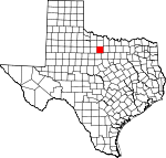
Young County, Texas Basics:
Young County Texas - Government Site
Population: 18,299
Area: 914 square miles
County seat: Graham
Area code(s) in use: 940
Time zone: CST
High school graduate or higher: 79.9%
Bachelor's degree or higher: 15.4%
Median household income: $42,008
Persons in poverty: 15.2%
Home ownership rate: 68.7%
Mean travel time to work: 15.7 minutes
Adjacent counties:
Archer Baylor Jack Palo Pinto Stephens Throckmorton
Places in Young County, Texas
Graham Municipal Airport,
Olney Municipal Airport,
Rob Airport,
Rosser Ranch Airport Brier Bend,
Gooseneck Bend,
Herron Bend,
Johnson Bottom,
Long Bend,
Miller Bend,
Ming Bend,
Salem Bend,
Waco Bend,
Wild Bend Gooseneck Bridge Graham Fire and Rescue Department, Library of Graham,
National Theater, Olney Community Library,
Olney Fire Department,
Spencer Boyd Street Houses,
Young County Jail,
Young County Rural Volunteer Fire Department Station 1,
Young County Rural Volunteer Fire Department Station 2,
Young County Rural Volunteer Fire Department Station 3,
Young County Rural Volunteer Fire Department Station 4,
Young County Rural Volunteer Fire Department Station 5 Belknap Cemetery,
Brooks Cemetery,
Center Ridge Cemetery,
Donnell Cemetery,
Farmer Cemetery,
Gooseneck Cemetery,
Hawkins Chapel Cemetery,
Huffstuttle Cemetery,
Indian Mound Cemetery,
Loving Cemetery,
Medlan Cemetery,
Ming Bend Cemetery,
Mountain Home Cemetery,
Murray Cemetery,
Oak Grove Cemetery,
Orth Cemetery,
Padgett Cemetery,
Peveler Cemetery,
Pioneer Cemetery,
Proffitt Cemetery,
Reynolds Cemetery,
Saint Luke Cemetery,
South Bend Cemetery,
Tonk Valley Cemetery,
Tyra Cemetery,
Woolfolk Cemetery,
Wray Cemetery Bethel Baptist Church,
Church of Christ,
Church of Christ,
Church of God,
Church of God,
Church of the Nazarene,
Cumberland Presbyterian Church,
Faith Baptist Church,
Faith Lutheran Church,
Flint Creek Mission,
Grace Chapel Church,
Holy Spirit Episcopal Church,
Immanuel Baptist Church,
Loving Highway Church of Christ,
Medlan Chapel,
Morningside Baptist Church,
Olney Assembly Church,
Pleasant Valley Church,
Plum Grove Church,
Saint Luke Church,
Saint Luke Lutheran Church,
Saint Marys Catholic Church,
Salem Methodist Church,
Tonk Valley Church Deer Head Bluff Campbell Lake Dam,
Clayton Lake Dam,
Graham Lake Dam,
Johnston Lake Dam,
Lake Eddleman Dam,
Lake Graham Dam,
Manning Vick Dam 1,
Manning Vick Lake Number 2 Dam,
Newcastle Dam,
Newman Lake Dam,
Old Eureka Mill Reservoir Dam,
Scott Lake Dam,
Whiskey Creek Dam,
Woodward Lake Dam Coffee Flat Graham Regional Medical Center,
Hamilton Hospital Drummond,
Flatrock Community Center,
Graham Power Plant Belknap Mine Number 1,
Belknap Mine Number 2,
Belknap Mine Number 3,
Belknap Mine Number 4,
Belknap Mine Number 5 Benson Oil Field,
Graham Oil Field,
James Oil Field,
Knox Oil Field,
Larimore Oil Field,
Ligon Oil Field,
Prideaux Oil Field,
Wilton Oil Field Firemens Park,
Fort Belknap State Park,
Fort Belknap State Park,
Griffin Park,
Newton Field,
Shawnee Park,
Sports Park,
Victory Park Belknap (historical), Brazos Indian Reservation (historical),
Bunger,
Eliasville,
Farmer,
Graham, Herron City (historical),
Jean,
Loving,
Markley,
Murray,
Newcastle,
Old Caseyville Crossing,
Olney,
Padgett,
Proffitt,
Proffitt Crossing,
Red Top,
South Bend,
True,
Twin Mountains Graham Post Office,
Loving Post Office,
Newcastle Post Office,
Olney Post Office,
South Bend Post Office Belknap Mountains Bait Tank,
Clayton Lake,
Graham Lake,
Johnston Lake,
Lake Eddleman,
Lake Graham,
Manning Vick Lake 1,
Manning Vick Lake Number 2,
Newcastle Lake,
Newman Lake,
Old Eureka Mill Reservoir,
Red Tank,
Scott Lake,
Tub Tank,
Whiskey Creek Reservoir,
Woodward Lake Crestview Elementary School,
East Ward Junior High School,
Graham High School,
Graham Junior High School,
Graham Learning Center,
Lincoln School, Newcastle Elementary School, Newcastle High School,
Olney Elementary School,
Olney High School,
Olney Junior High School,
Shawnee Elementary School,
Shawnee School,
Woodland Elementary School Agency Springs, Baylor Springs, Belknap Springs, Caddo Springs, Cottonwood Springs, Flat Top Springs, Herndon Springs (historical), Indian Springs, Kay Springs, Live Oak Springs (historical), Shawnee Springs, Sloan Springs, Spring Branch Springs, Steele Springs, Thompson Springs, Tonk Springs, Turkey Springs (historical), Whiskey Springs
Big Skid Creek,
Bitter Creek,
Boggy Creek,
Briar Creek,
Brier Branch,
Brushy Creek,
Bull Branch,
California Creek,
Camp Creek,
Clear Fork Brazos River,
Coal Branch,
Connor Creek,
Coon Branch,
Cove Creek,
Cribb Station Creek,
Dead Horse Creek,
Dry Branch,
Dry Creek,
Dry Creek,
Elm Creek,
Farmers Branch,
Filibuster Creek,
Fish Creek,
Flatrock Creek,
Flint Creek,
Gage Creek,
Gibbens Creek,
Hamby Branch,
Huffstuttle Creek,
Jim Anderson Creek,
Kickapoo Creek,
Little Dry Creek,
Little Salt Creek,
Little Skid Creek,
McCumber Branch,
McMillan Branch,
Medlan Branch,
Mud Creek,
Mule Pen Branch,
North Fork Fish Creek,
North Tonk Branch,
Oak Creek,
Peacock Creek,
Peveler Creek,
Phillip George Branch,
Post Oak Creek,
Rabbit Creek,
Ratliff Branch,
Rattlesnake Creek,
Red Haw Creek,
Salt Branch,
Salt Creek,
South Fork Gage Creek,
South Tonk Branch,
Spring Branch,
Timmons Creek,
Tonk Branch,
Turtle Hole Creek,
Whiskey Creek,
White Water,
Willow Branch,
Willow Pond Creek Bare Mountain,
Bass Mountain,
Beehive Mountain,
Cement Mountain,
Crow Peak,
Dobbs Hill,
Flag Mountain,
Haynes Mountain,
Indian Mountain,
Kisinger Mountain,
Rattlesnake Mountain,
Round Mountain,
Shin Oak Mountain,
Sidney Mountain,
Skid Mountain,
Spy Knob,
Tackett Mountain,
Wolf Mountain KSWA-AM (Graham),
KWKQ-FM (Graham) Buck Hollow,

