Garfield County, Utah Basics:


Garfield County Utah - Government Site

Population: 5,102
Area: 5175 square miles
County seat: Panguitch
Area code(s) in use: 435
Time zone: MST
High school graduate or higher: 91.1%
Bachelor's degree or higher: 21.2%
Median household income: $44,345
Persons in poverty: 12.3%
Home ownership rate: 80.3%
Mean travel time to work: 12.2 minutes
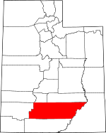
Adjacent counties:
Beaver  Iron  Kane  Piute  San Juan  Wayne  

Find in Utah

Map of the Garfield County area


Our detail map of Garfield County shows the Garfield County, Utah boundary lines and other interesting items.

Places in Garfield County, Utah

  Airports     show all on map

Bryce Canyon Airport, Bryce Canyon Heliport, Bryce Woodland Estates Landing Strip, Bullfrog Basin Airport, Escalante Municipal Airport, Hite Airport, Panguitch Municipal Airport, Panguitch Municipal Airport, Pfeiler Ranch Airport, Simplot Airstrip, United States Forest Service Clinic Heliport

  Arches     show all on map

Ant Knolls, Bowington Arch, Brimhall Bridge, Cave Arch, Cedar Wash Arch, Escalante Natural Bridge, Fairview Natural Bridge, Horizon Arch, Lamanite Arch, Mano Arch, Maverick Bridge, Metate Arch, Phipps Arch, Promise Rock Arch, Serenity Natural Bridge, Two Bridges, Whitmore Arch

  Areas     show all on map

Bryce Amphitheater, Deer Creek Recreation Area, Devils Garden, Devils Garden Outstanding Natural Area, Egypt, Ernies Country, Fairyland, North Escalante Canyon Outstanding Natural Area, Phipps-Death Hollow Outstanding Natural Area, Queens Garden, Raggy Draws, Shurtz Bush, Sin-av-to-weap, Star Seep, The Doll House, The Doll House, The Gulch Outstanding Natural Area, The V, Twin Trees, Wolverine Petrified Wood Area

  Bars     show all on map

Anderson Bar (historical), Maidenwater Sands, Moqui Bar, Oyster Shell Reef

  Basins     show all on map

Black Hole, Blue Basin, Bromide Basin, Bulldog Hole, Cons Hole, Copper Basin, Dougherty Basin, Edmunds Hole, Emery Valley, Fiddler Cove, Garden Basin, Granite Hole, Granite Valley, Horse Valley, Horse Valley, Horseshoe Basin, Little Creek Valley, Little Valley, Little Valley, Mossy Dell, Potato Valley, Pyserts Hole, Red Cove, Sawmill Basin, The Cove, The Cove, The Cove, The Pockets, Tropic Valley, Woodruff Hole

  Bays     show all on map

Glencove

  Benches     show all on map

Antimony Bench, Asay Bench, Baker Bench, Big Bown Bench, Black Ledge, Bowington Bench, Brigham Tea Bench, Bulldog Bench, Cedar Creek Bench, Choprock Bench, Clark Bench, Coal Bench, Copper Creek Benches, Coyote Benches, Dark Valley Shelf, Dry Bench, Dry Bench, East Baker Bench, East Bench, Four Mile Bench, Haymaker Bench, Horse Bench, Indian Spring Benches, Johnson Bench, King Bench, King Bench, King Bench, Little Bown Bench, Little Creek Wood Bench, McGath Point Bench, Middle Bench, Mud Spring Bench, New Home Bench, Pennell Creek Bench, Pete Steele Bench, Poison Creek Bench, Poison Spring Benches, Pretty Tree Bench, Rattlesnake Bench, Red Benches, Sand Wash Bench, Sandy Creek Benches, Sawmill Bench, Showalter Bench, Silver Falls Bench, Slickrock Saddle Bench, Star Creek Benches, Steep Creek Bench, Thompson Ledge, Walt Bench, Whiteman Bench, Wolverine Bench

  Bends     show all on map

Elbow of the Sandy, Holbys Bottom, John Allen Bottom, Mille Crag Bend, Sink Holes

  Bridges     show all on map

Hite Crossing, Tower Bridge

  Buildings     show all on map

Antimony Volunteer Fire Department, Beck Electronic Site, Boulder Volunteer Fire Department, Bryce Canyon National Park Fire Department, Bryce Canyon National Park Visitors Center, Escalante Police Department, Escalante Volunteer Fire Department, Garfield County Ambulance, Garfield County Sheriff's Office Panquitch, Garkane Hydroelectric Plant, Hatch Volunteer Fire Department, Henrieville Volunteer Fire Department, Mammoth Creek Volunteer Fire Department, Panguitch Volunteer Fire Department, Sawmill, Tropic Volunteer Fire Department

  Canals     show all on map

Antelope Ditch, Barton Tebbs LaFevre Canal, Dalley Ditch, East Bench Canal, East Fork Canal, East Panguitch Canal, Long Canal, Lossee Canal, Marshall Ditch, McEwen Ditch, Old State Ditch, Panguitch Canal, South Ditch, Tailrace Canal, Tropic Ditch, West Ditch

  Capes     show all on map

Bowns Point, Bryce Point, Buckacre Point, Cave Point, Chokecherry Point, Clay Point, Fault Point, Good Hope, Inspiration Point, Long Neck, Middle Point, Powell Point, Saleratus Point, Sawmill Point, Sawyer Point, Short Neck, South Point, Trail Point

  Cemeteries     show all on map

Antimony Cemetery, Boulder Cemetery, Cannonville Cemetery, Escalante Cemetery, Georgetown Cemetery, Hatch Cemetery, Henrieville Cemetery, Panguitch City Cemetery, Spry Cemetery, Tropic Cemetery, Widtsoe Cemetery

  Churches     show all on map

First Baptist Church, The Church of Jesus Christ of Latter Day Saints, The Church of Jesus Christ of Latter Day Saints, The Church of Jesus Christ of Latter Day Saints, The Church of Jesus Christ of Latter Day Saints, The Church of Jesus Christ of Latter Day Saints, The Church of Jesus Christ of Latter Day Saints, The Church of Jesus Christ of Latter Day Saints, The Church of Jesus Christ of Latter Day Saints, The Church of Jesus Christ of Latter Day Saints

  Cliffs     show all on map

Black Jump, Casto Bluff, Chinese Wall, Circle Cliffs, Deer Point, Fairyland Point, Farview Point, Fish Creek Point, Hindu Temples, Jump-up, Liberty Castle, Mud Springs Point, Ormand Point, Piracy Point, Red Breaks, Schoolhouse Ledge, Shakespear Point, Snowbank, South Rim, Sunrise Point, Sunset Cliffs, Sunset Point, Table Cliff, Tar Cliff, The Terrace

  Dams     show all on map

Barker Dam, Jacobs Valley Dam, Johnson Storage Dam, Long Willow Bottom Dam, Lower Barker Dam, Lower Bowns Dam, North Creek Dam, Oak Creek Dam, Pacer Lake Reservoir Dam, Panguitch Lake Dam, Pine Creek Dam, Pollywog Lake Dam, Round Willow Bottom Dam, Roundy Reservoir Dam, Spectacle Lake Dam, Tropic Reservoir Dam, Wide Hollow Dam

  Falls     show all on map

Lower Calf Creek Falls, Marys Veil, Pillings Cascade, Upper Calf Creek Falls

  Flats     show all on map

Andy Miller Flats, Antone Flat, Apple Brush Flat, Baker Pasture, Basin Flats, Bear Flat, Bear Flat, Beef Meadows, Big Flat, Big Spencer Flats, Blue Grass, Boulder Meadows, Bowery Flat, Buckaroo Flat, Bull Flat, Burrows Flat, Butterfly Flat, Camp Flat, Canaan Bottom, Cave Flat, Cherry Flat, Chokecherry Meadow, Corral Flat, Cow Flat, Dandelion Flat, Dandelion Flat, Davis Flat, Dry Lake Flat, Dugout Flat, Flint Flat, Hancock Flat, Haws Pasture, Hay Lakes Flat, Houston Flat, Jorgenson Flat, Judd Pasture, Kings Pasture, Liston Flat, Little Beef Meadows, Little Desert, Little Egypt, Little Spencer Flat, Log Flat, Lone Cedar Flat, Lonesome Pine Flat, Main Flat, Marshall Meadow, Marts Pasture, Mud Lake Flat, Mule Flat, Nasty Flat, Parks Pasture, Pearl Flat, Pleasant Creek Flats, Pleasant Creek Meadow, Riddle Flat, Rockwell Flat, Roundup Flat, Roundup Flat, Sage Flat, Sand Flat, Seep Flat, Sheep Creek Flat, Slate Flat, Star Flat, Stink Flats, Sunflower Flat, Tantalus Flats, Tenmile Flat, The Flats, Uinta Flat, Washboard Flat, Waterhole Flat, White Canyon Flat, Whites Flat, Whites Flat, Wildcat Pasture, Willow Bottom, Winnemucca Flat, Yankee Meadow

  Forests     show all on map

Dixie National Forest

  Gaps     show all on map

Bull Creek Pass, China Neck, Cottonwood Pass, East Saddle, Fremont Pass, Hall Divide, Pennellen Pass, Sand Pass, Slickrock Saddle, Stanton Pass, Stevens Narrows, Sunset Pass, The Gap, The Narrows, The Pass, Wickiup Pass

  Hospitals     show all on map

Garfield Memorial Hospital, U.S. Forest Service Clinic

  Islands     show all on map

Monte Cristo Island

  Lakes     show all on map

Antimony Lake, Auger Hole Lake, Baker Lake, Bakeskillet Lake, Barney Lake, Bear Lake, Bendder Pond, Bess Lake, Big Lake, Big Lake, Black Lake, Blue Grass Lake, Blue Lake, Blue Lake, Bowns Lake, Bug Lake, Butterfly Lake, Chriss Lake, Chuck Lake, Circle Lake, Coyote Lake, Crater Lake, Cresecent Lake, Cuddyback Lake, Cyclone Lake, Dark Valley Lake, Deer Creek Lake, Deer Lakes, Divide Lake, Dog Lake, Donkey Lake, Dry Lake, Dry Lake, Dry Lake, Dry Lake, Dry Lake, East Boulder Lakes, East Lake, Elbow Lake, Five Lakes, Flat Lake, Four Lakes, Granite Pond, Grass Lake, Grass Lakes, Green Lake, Green Lake, Halfmoon Lake, Hay Lakes, Horse Lake, Horse Lake, Horseshoe Lake, Joes Pond, Judd Pasture Troughs, Lake in the Flat Meadow, Lake Philo, Ledge Lake, Long Lake, Lost Lake, Marks Pond, McGath Lake, Meeks Lake, Mima Lake, Mud Lake, Mud Lake, Mud Lake, Noon Lake, Otter Lake, Pacer Lake, Panguitch Lake, Pelham Lake, Pleasant Lake, Pollywog Lake, Posy Lake, Purple Lake, Rain Lakes, Riddle Lake, Ridge Lake, Riggs Pond, Rim Lake, Rock Lake, Rock Lake, Round Lake, Row Lakes, Sawmill Lake, Scout Lake, Seed Lakes, Slickrock Water, Steep Creek Lake, Surveyors Lake, Trail Lake, Tri-Corner Pond, Tule Lakes, Twin Lakes, Twin Lakes, Twin Lakes, West Lake, Yellow Lake

  Locales     show all on map

Asay Town, Baker Bench Petroglyphs, Barker Reservoir Campground, Beaver Dam Lodge, Best Inscription-1891, Blue Spruce Campground, Boynton Lookout, Bryce Canyon Lodge, Bryce Pioneer Village, Bryce Point Overlook, Bullfrog Creek Overlook, Calf Creek Campground, Calf Creek Recreation Area, Cedar Mesa Campground, Cowpuncher Guard Station, Daves Hollow Forest Service Station, Deer Creek Campground, Deer Trail Logde, Desert Overlook, Devils Garden Campground, Eagle City, Eddy Inscription-1927, Escalante District Ranger Station, Escalante Petrified Forest Campground, Fairyland Point Overlook, Farview Point Overlook, Flint Trail Overlook, Garfield County Fairgrounds, Griffin Ranch, Hall Ranch, Heaps Ranch, Hitch-N-Post Campground, Hog Spring Picnic Area, Hog Springs Campground, Hog Springs Picnic Area, Inspiration Point Overlook, Johnson Mill, Johnson Ranch, Johnsonville Site, Jones Corral Guard Station, Jubilee Guard Station, King Creek Campground, King Ranch, King Ranch, Kolb Inscription-1911, Lake Powell Overlook, Little Egypt Geologic Site, Lonesome Beaver Campground, Long Canyon Overlook, Long Neck Cabin, Losee, Lower Bown Campground, Mammoth Springs Campground, McMillan Springs Campground, Merrill Ranch, Mogui Motel Campground, Nature Center, North Campground, Oak Creek Campground, Oak Creek Forest Camp, Ott Ranch, Panguitch Fish Hatchery, Panguitch Lake North Campground, Panguitch Lake South Campground, Panquitch Lake Forest Service Station, Paria View Overlook, Pine Creek Campground, Pine Lake Campground, Piracy Point Overlook, Pleasant Creek Campground, Posy Lake Campground, Powell District Ranger Station, Powell Survey Cairn, Red Canyon Campground, Riddle Ranch, Rim View, Riverside Campground, Roundy Ranch, Rubys Inn, Rustic Lodge, Sandy Ranch, Spry, Star Springs Campground, Strike Valley Overlook, Sunrise Point Overlook, Sunset Campground, Sunset Point Overlook, Swamp Canyon Overlook, The Post, The Triangle, Trachyte Ranch, Twentyfive Mile Corral, Twentymile Corral, Twin Trees Campground, Upper Valley Guard Station, White Bridge Campground, White Ranch, Wildcat Ranger Station

  Mines     show all on map

Bromide Mine, Cherry Creek Mine, Corn Creek Mine, Del Mont Mine, Hotshot Prospect, Shakespeare Mine, Shootaring Mine, Sneaky Prospect, Stanton Mine

  Parks     show all on map

Anasazi Historical Site, Bryce Canyon National Park, Butch Cassidy Home, Escalante Petrified Forest State Park, George Hobbs Historical Site, Mountain Ridge RV Park, Panguitch KOA, Pink Cliffs Village

  Pillars     show all on map

Alley Oop and Dinny, Carmel and Wiseman, Castle Rock, Coliseum, Fairy Castle, Grainery Rock, Gullivers Castle, Happy Family, Hat Shop, Hoskinnini Monument, Jiggs, Joseph and Mary, Katzenjammer Kids, Mutt and Jeff, Organ Grinders Monkey, Pagoda, Palace of the Fairy Queen, Pans Pinnacle, Queen Victoria, Queens Castle, Sadies Nipple, Silent City, Temple of Osiris, Temples of the Gods, The Alligator, The Button, The Fins, The Gossips, The Mother and Child, The Pinnacle, The Pope, The Sentinel, The Sewing Machine, Thors Hammer, Three Wiseman, Turtle, Wall of Windows, Wall Street, White Face

  Plains     show all on map

Aquarius Plateau, Cane Spring Desert, Sevier Plateau, Table Cliff Plateau

  Populated Places     show all on map

Antimony, Bear Valley Junction, Bone Valley, Boulder Town, Bryce Canyon, Bryce Canyon City, Cannonville, Eggnog, Escalante, Hatch, Henrieville, Hillsdale, Hite (historical), Juniper Park Resort, Lake View Resort, Osiris, Panguitch, Panguitch Lake Resort, Spry, Three Forks, Ticaboo, Tropic, Widtsoe, Widtsoe Junction

  Post Offices     show all on map

Boulder Post Office, Bryce Canyon Post Office (historical), Panguitch Post Office

  Ranges     show all on map

Black Hills, Escalante Mountains, Henry Mountains, Little Rockies, Mount Ellen, Purple Hills, The Potholes

  Rapidss     show all on map

Dark Canyon Rapids, Mile Long Rapids, Ticaboo Number 1 Rapids, Ticaboo Number 2 Rapids

  Reserves     show all on map

Box-Death Hollow Wilderness

  Reservoirs     show all on map

Barker Reservoir, Barney Reservoir, Bastian Reservoir, Big Swale Reservoir Number 1, Big Swale Reservoir Number 2, Bowns Reservoir, Bucket Hollow Reservoir, Cameron Wash Reservoir Number 1, Cass Creek Reservoir, Corner Reservoir, Corral Flat Reservoir, Cottonwood Tanks, Coyote Hollow Reservoir, Coyote Reservoir, Dan Day Reservoir, Death Hollow Reservoir Number 1, Death Hollow Reservoir Number 2, Death Ridge Reservoir, Indian Spring Reservoir, Jacobs Reservoir, Joe Lay Reservoir, Johnson Storage Reservoir, Jones Corral Reservoir, Kings Pasture Reservoir, Lone Cedar Reservoir, Long Willow Bottom Reservoir, Lost Spring Reservoir, Lost Spring Reservoir, Lower Barker Reservoir, Lower Bowns Reservoir, Maidenwater Reservoir, Milk Creek Reservoir, Moki Tank, Moosman Reservoir, Mountain Spring Reservoir, Mule Flat Reservoir, Muley Tanks, North Creek Reservoir, North Creek Reservoir, Oak Creek Reservoir, Pacer Lake, Panguitch Lake, Pelham Hollow Reservoir, Pine Lake, Poison Creek Reservoir Number 1, Poison Creek Reservoir Number 2, Pollywog Lake, Poulas Tanks (historical), Red Tanks, Reynolds Spring Reservoir, Rim Reservoir, Road Hollow Reservoir, Robs Reservoir, Rock Hollow Reservoir, Rockwell Reservoir, Rocky Ford Reservoir, Round Willow Bottom Reservoir, Round Willow Bottom Reservoir, Roundy Reservoir, Spectacle Lake, Tall Four Reservoir, Ticaboo Reservoir, Ticaboo Reservoir, Tropic Reservoir, Tropic Reservoir, West Fork Reservoir, Wide Hollow Reservoir, Wide Hollow Reservoir, Wildcat Reservoir, Willow Tanks

  Ridges     show all on map

Barnhurst Ridge, Big Ridge, Big Ridge, Bitter Creek Divide, Black Ridge, Burned Ridge, Cedar Point, Copper Ridge, Cougar Ridge, Deadman Ridge, Death Ridge, Freds Ridge, Ghost Ridge, Granite Ridges, Head of Bullfrog, Hells Backbone, Hells Backbone Ridge, Hogs Back, Horseshoe Ridge, Mammoth Ridge, Mud Spring Ridge, North Summit Ridge, Ocean Point, Park Ridge, Pistol Ridge, Red Point, Rock Spring Ridge, South Creek Ridge, South Summit Ridge, Taylor Ridges, The Backbone, The Big Ridge, The Hogback, Trachyte Point, Water Pocket Fold, Wickiup Ridge, Windmill Ridge

  Schools     show all on map

Antimony School, Boulder School, Bryce Valley High School, Escalante High School, Escalante School, Panguitch High School-Middle School, Panguitch School, Ticaboo High School, Ticaboo School

  Slopes     show all on map

Allen Dump, Devils Slide, Stairs Slope

  Springs     show all on map

Airplane Spring, Antelope Spring, Asay Spring, Aspen Spring, Beebe Spring, Benson Springs, Berry Spring, Big Point Spring, Bill Pinney Spring, Billy Spring, Billy Spring, Birch Spring, Birch Spring, Birch Spring, Birch Spring, Birch Spring, Birch Springs, Blind Spring, Blue Spring, Blue Spring, Boiling Spring, Bowers Spring, Box Spring, Bull Rush Spring, Burnt Spring, Burro Spring, Cameron Troughs, Camp Spring, Cane Spring, Carry Water Spring, Casto Springs, Cellar Spring, Center Creek Spring, Chipmunk Spring, Chucker Spring, Clarence Creek Spring, Clay Seep, Clayton Spring, Coal Pit Springs, Colt Spring, Colt Spring, Copper Basin Spring, Copper Spring, Cottonwood Spring, Cougar Spring, Cougar Spring, Cove Spring, Coyote Spring, Dave Teeples Spring, Deep Creek Spring 1, Deep Creek Spring 2, Dipping Vat Spring, Dipping Vat Spring, Dripping Rock Seep, Dripping Spring, Fivemile Spring, Flint Seep, Garden Spring, Gates Spring, Gibbons Springs, Gibbons Springs, Gold Creek Spring, Grassy Troughs, Gresham Spring, Griffin Spring, Hancock Spring, Hog Ranch Spring, Hog Spring, Hole Spring, Hole Spring, Horse Spring, Hunter Spring, Indian Spring, Indian Spring, Indian Spring, Iron Spring, Jackass Spring, Jackass Spring, Jones Corral Spring, Judd Spring, Lake Hollow Spring, Lava Spring, Lecleed Spring, Limerock Spring, Lost Spring, Lost Spring, Lyle Spring, Maidenwater Spring, Maidenwater Spring, Mammoth Spring, McClellan Spring, Miller Seep, Mitchell Spring, Mossy Dell Spring, Mountain Spring, Mud Seep, Mud Spring, Mud Spring, Mud Spring, Mud Spring, Mud Spring, Mud Spring, Oak Spring, Onion Flats Seep, Papoose Spring, Paradise Spring, Pine Spring, Poison Spring, Pole Spring, Posy Spring, Quaking Aspen Spring, Redcedar Spring, Rock Spring, Rock Spring, Rock Spring, Roundy Spring, Serviceberry Spring, Shaker Spring, Skull Spring, Spruce Spring, Squaw Spring, Squaw Spring, Star Spring, Stump Spring, Sulphur Spring, Taylor Spring, Tebbs Spring, Tenmile Spring, The Gap Spring, Thompson Seep, Three Springs, Ticaboo Shelf Spring, Ticaboo Shelf Spring, Tom Best Spring, Trough Spring, Twin Seeps, Two Pipe Springs, Upper Spring, Whiteman Spring, Wild Horse Spring, Wild Horse Spring, Willow Spring, Willow Spring, Willow Spring, Wilson Spring, Winnemucca Spring, Wolf Spring, Woodruff Spring, Yellow Spring, Yellowjacket Spring

  Streams     show all on map

Allen Creek, Antimony Creek, Asay Creek, Badger Creek, Bear Creek, Bear Creek, Behanin Creek, Benson Creek, Berry Spring Creek, Birch Creek, Birch Creek, Birch Creek, Bitter Creek, Bitter Spring Creek, Black Creek, Blubber Creek, Blue Fly Creek, Blue Spring Creek, Blue Spring Creek, Boulder Creek, Brady Creek, Browns Creek, Bryce Creek, Bull Rush Creek, Bulldog Creek, Bullfrog Creek, Bunker Creek, Butler Creek, Calf Creek, Campbell Creek, Canaan Creek, Carter Creek, Cass Creek, Castle Creek, Cedar Fork, Center Creek, Center Creek, Cherry Creek, Cherry Creek, Chokecherry Creek, Chokecherry Creek, Chokecherry Creek, Clarence Creek, Clay Creek, Copper Creek, Copper Creek, Corn Creek, Cottonwood Creek, Cow Creek, Coyote Creek, Crescent Creek, Deep Creek, Deep Creek, Deer Creek, Deer Creek, Delong Creek, Dirty Devil River, Dry Creek, Dry Creek, Dry Creek, Dry Fork, Dry Fork, Dry Fork, Dry Fork, Dry Fork, Dry Fork, Dry Fork Rock Creek, Dugout Creek, Dunfey Creek, Durfey Creek, East Creek, East Deer Creek, East Fork Boulder Creek, East Fork Hunt Creek, East Fork North Creek, Echard Creek, Forest Creek, Frisky Creek, Gold Creek, Granite Creek, Griffin Creek, Grimes Creek, Hall Creek, Halls Creek, Hancock Creek, Hancock Fork, Hansen Creek, Haycock Creek, Henderson Creek, Henderson Creek, Henrieville Creek, Heward Creek, Hoodle Creek, Horse Creek, Hungry Creek, Hunt Creek, Ipson Creek, Judd Creek, King Creek, Lake Creek, Left Fork Blue Fly Creek, Left Fork Haycock Creek, Left Fork Sanford Creek, Left Fork Slate Creek, Left Hand Allen Creek, Limekiln Creek, Limestone Creek, Little Cottonwood Creek, Little Cow Creek, Little Creek, Little Forest Creek, Lizzie Creek, Lost Creek, Lost Creek, Lost Creek, Lost Spring Wash, Maidenwater, Mamie Creek, Mammoth Creek, Middle Deer Creek, Middle Fork Ticaboo Creek, Middle Fork Ticaboo Creek, Middle Fork Ticaboo Creek, Milk Creek, Milk Creek, Millers Creek, Miry Creek, Moody Creek, Mount Ellen Creek, Mountain Spring Fork, Mud Creek, Mud Spring Creek, Mud Spring Creek, Muley Creek, North Creek, North Creek, North Creek, North Fork Bullfrog Creek, North Fork Cottonwood Creek, North Fork Deep Creek, North Fork Deer Creek, North Fork Limekiln Creek, North Fork Pistol Creek, North Fork Prospect Creek, North Fork Silver Falls Creek, North Fork South Creek, North Fork Ticaboo Creek, North Fork Ticaboo Creek, North Fork Ticaboo Creek, Oak Creek, Panguitch Creek, Pass Creek, Pennell Creek, Peshliki Fork, Peshliki Fork Ticaboo Creek, Pine Creek, Pine Creek, Pine Creek, Pistol Creek, Poison Creek, Prospect Creek, Quaking Aspen Creek, Ranch Creek, Right Fork Blubber Creek, Right Fork Blue Fly Creek, Right Fork Haycock Creek, Right Fork Sanford Creek, Road Draw Creek, Rock Creek, Rocky Ford Creek, Sand Creek, Sandy Draw, Sanford Creek, Sevenmile Creek, Shitamaring Creek, Showalter Creek, Shurtz Bush Creek, Silver Falls Creek, Skunk Creek, Slate Creek, Smith Fork, South Creek, South Creek, South Fork Cottonwood Creek, South Fork Deep Creek, South Fork Deer Creek, South Fork Limekiln Creek, South Fork Oak Creek, South Fork Pistol Creek, South Fork Prospect Creek, South Fork Swett Creek, South Fork Ticaboo Creek, South Fork Ticaboo Creek, Speck Creek, Spring Branch, Spring Creek, Spring Creek, Star Creek, Steep Creek, Straight Creek, Sweetwater Creek, Sweetwater Creek, Swett Creek, Tantalus Creek, Thompson Creek, Threemile Creek, Ticaboo Creek, Trachyte Creek, Twitchell Creek, Upper Valley Creek, West Branch Pine Creek, West Deer Creek, West Fork Asay Creek, West Fork Boulder Creek, West Fork Hunt Creek, West Fork North Creek, White Creek, Wildcat Creek, Wildcat Creek, Willow Creek, Willow Creek, Willow Patch Creek, Willow Spring Creek, Wilson Creek, Wolverine Creek

  Summits     show all on map

Adams Head, Ant Knoll, Ant Knolls, Antimony Knoll, Asay Knoll, Aspen Point, Balancing Rock, Barney Top, Barton Peak, Bartons Peak, Battle Mountain, Bert Mesa, Big Point, Big Thomson Mesa, Birch Spring Knoll, Black Butte, Black Mesa, Black Mountain, Black Table, Blind Spring Mountain, Boat Mesa, Boulder Mountain, Bowers Knoll, Bristlecone Point, Browns Knoll, Buck Knoll, Buck Knoll, Bull Mountain, Bull Rush Peak, Bulldog Peak, Bulldog Ridge, Burnt Knoll, Burr Top, Canaan Peak, Cass Creek Peak, Cedar Mesa, Coal Bed Mesa, Cocks Comb, Colt Mesa, Cons Knoll, Cooper Knoll, Corral Point, Cottonwood Peak, Crescent Castle (historical), Crescent Castle (historical), Crow Peak, Danish Knoll, Davis Point, Deer Heaven, Deer Mountain, Dials Knob, Dickinson Hill, Dry Lakes Peak, Durfey Butte, Durffey Mesa, Farmers Knob, Fiddler Butte, Fivemile Ridge, Flake Mountain, Flat Top, Flat Top, Good Hope Mesa, Granite Knolls, Gravel Hill, Green Hill, Griffin Point, Griffin Top, Gunsight Butte, Hall Mesa, Hancock Peak, Hatch Mountain, Haycock Mountain, Henderson Point, Henrie Knolls, Horse Creek Top, Horse Pasture Mesa, Horse Valley Peak, Hoskinnini Mesa, Impossible Peak, Johns Knoll, Juds Knoll, Kaiparowitz Peak, Keller Knoll, Kimble and Turner Peak, Lamp Stand, Lands End, Little Dog Valley Peak, Little Mountain, Lost Knoll, Mahogany Hill, McGath Point, Mormon Temple, Mount Dutton, Mount Ellen Peak, Mount Ellsworth, Mount Hillers, Mount Holmes, Mount Ogden, Mount Pennell, Mount Pierson, Mud Canyon Butte, Nicks Peak, No Man Mesa, Noon Canyon Butte, North Block, Oak Creek Point, Oastler Castle (historical), Peak-a-boo Rock, Pelham Knoll, Pennell Creek Roughs, Pinto Knoll, Pioneer Mesa, Point Lookout, Ragged Mountain, Roger Peak, Roller Mill Hill, Seal Castle, Shootaring Point, Sinking Ship, South Block, Spring Knoll, Steele Butte, Stud Knoll, Studhorse Peaks, Sugarloaf, Swamp Canyon Butte, Swap Mesa, Table Mountain, Tanner Knoll, Tarantula Mesa, Teapot Rock, The Baldys, The Block, The Block, The Blues, The Cathedral, The Hat, The Hat, The Horn, The Horn, The Pine Hills, The Salmon, Ticaboo Mesa, Timbered Knoll, Turkey Knob, Turn of Bullfrog, Wagon Box Mesa, White Mountain, White Rocks, Wildcat Mesa, Wilson Peak, Window Rock

  Swamps     show all on map

Velvet Lake

  Towers     show all on map

Bryce Valley Translator

  Trails     show all on map

Black Burn Trail, Blind Trail, Boulder Mail Trail, Burnt Hollow Trail, Fairyland Loop Trail, Flint Trail, Horse Trail, Indian Trail, Navajo Loop Trail, Peekaboo Loop Trail, Queens Garden Trail, Rim Trail, Rocky Ford Trail, Sheep Creek Connecting Trail, Squaw Trail, Swamp Canyon Connecting Trail, The Golden Stairs, Under-the-Rim Trail, Whiteman Connecting Trail

  Tunnels     show all on map

Cameron Troughs, John Cameron Troughs

  Valleys     show all on map

Adobe Swale, Ahlstrom Hollow, Allen Well Draw, Alvey Wash, Baker Wash, Barker Hollow, Barney Cove, Bear Canyon, Beck Hollow, Big Hollow, Big Hollow, Big Horn, Big Swale, Birch Canyon, Black Canyon, Black Rock Valley, Blind Spring Draw, Blind Trail Wash, Boulder Swale, Box Canyon, Bridge Hollow, Broken Draw, Bromide Canyon, Brush Hollow, Bryce Canyon, Buck Hollow, Bucket Hollow, Bull Run Canyon, Bullberry Hollow, Bulldog Hollow, Burnes Hollow, Burnt Hollow, Burr Canyon, Burro Canyon, Butch Cassidy Draw, Butler Canyon, Butler Wash, Butler Wash, Butt Canyon, Cabin Hollow, Calf Canyon, Calf Canyon, Calf Canyon, Callings Hollow, Cameron Wash, Cameron Wash, Campbell Canyon, Carcass Canyon, Casto Canyon, Casto Wash, Cherry Hollow, Circleville Canyon, Clay Canyon, Clearwater Canyon, Coal Bed Canyon, Coal Canyon, Coal Pit Wash, Coleman Hollow Wash, Cope Canyon, Corral Canyon, Corral Hollow, Cottonwood Canyon, Cottonwood Wash, Cottonwood Wash, Cougar Hollow, Cove Canyon, Coyote Hollow, Coyote Hollow, Creek Canyon, Dark Canyon, Dark Valley, Dave Canyon, Daves Hollow, DD Hollow, Dead Mare Wash, Death Canyon, Death Hollow, Death Hollow, Death Hollow, Death Hollow, Death Hollow, Deer Canyon, Divide Canyon, Divide Canyon, Doc Lewis Hollow, Dog Valley, Dry Canyon, Dry Hollow, Dry Hollow, Dry Hollow, Dry Hollow, Dry Hollow, Dry Lake Swale, Dry Wash, Dry Wash, Dry Wash, East Boulder Draw, East Fork Cope Canyon, East Fork North Canyon, East Moody Canyon, East Valley, Easter Pasture Canyon, Echard Canyon, Egg Canyon, Elephant Hollow, Escalante Canyon, Fairyland Canyon, Fiddler Cove Canyon, Five Canyon, Fivemile Hollow, Fivemile Wash, Flake Swale, Flint Cove, Fourmile Canyon, Fourmile Canyon, France Canyon, Glory Cove, Grand Gulch, Graveyard Hollow, Gussie Draw, Halfway Hollow, Halfway Hollow, Hancock Canyon, Happy Canyon, Harris Wash, Hatch Canyon, Hawkins Canyon, Heaps Canyon, Hell Hole, Henderson Canyon, Hillsdale Canyon, Hog Canyon, Horse Canyon, Horse Spring Canyon, Horse Valley, Horse Valley, Hot Canyon, Hurricane Hollow, Imperial Valley, Indian Gulch, Indian Spring Draw, Ingram Hollow, Iron Spring Draw, Jacobs Valley, Jake Hollow, Jimmie Canyon, John L Swale, Johns Valley, Johnson Canyon, Johnson Hollow, Jolley Hollow, Jones Corral Draw, Lake Draw, Lake Hollow, Larb Hollow, Left Fork Proctor Canyon, Left Hand Collet Canyon, Lightning Draw, Lightning Hollow, Limekiln Draw, Limerock Canyon, Little Coal Pit Wash, Little Dog Valley, Little Henderson Canyon, Little Jake Hollow, Little Valley, Little Valley Canyon, Little Valley Wash, Log Hollow, Long Canyon, Long Canyon, Long Draw, Long Hollow, Losee Canyon, Lost Spring Draw, Lost Spring Wash, Main Canyon, Manning Hollow, Marinus Canyon, Marshall Canyon, Maverick Draw, McCardy Canyon, Meadow Canyon, Meeks Draw, Merrill Hollow, Mexican Hollow, Middle Moody Canyon, Mill Hollow, Mitchell Canyon, Moosman Draw, Mud Canyon, Mud Spring Canyon, Mud Spring Draw, Muley Twist Canyon, Myers Valley, Narrow Canyon, Nazer Draw, Noon Canyon, North Canyon, North Coleman Canyon, North Creek Draw, North Fork Paradise Canyon, North Hall, North Hatch Canyon, North Wash, Norton Hollow, Oak Draw, Pacewell Draw, Paradise Canyon, Pardner Canyon, Paria Amphitheater, Paria Hollow, Pasture Canyon, Pasture Wash, Pat Willis Draw, Peekaboo Canyon, Pelham Hollow, Pet Hollow, Peterson Wash, Phipps Wash, Pine Canyon, Pine Hollow, Pine Hollow, Pipe Spring Canyon, Poison Spring Canyon, Poison Wash, Pole Canyon, Pole Canyon, Pole Canyon, Pole Corral Draw, Pole Hollow, Porter Canyon, Proctor Canyon, Race Hollow, Raggy Canyon, Rainbow Draw, Range Canyon, Range Canyon, Rat Seep Hollow, Red Canyon, Red Canyon, Riggs Canyon, Right Fork Death Hollow, Right Fork Little Jake Hollow, Right Fork Proctor Canyon, Right Fork Wide Hollow, Right Hand Collet Canyon, Road Draw, Road Hollow, Rock Canyon, Rock Canyon, Rock Spring Draw, Russell Hollow, Sage Hen Draw, Sage Hen Hollow, Saleratus Wash, Salt Gulch, Salt Lick Draw, Sand Hollow, Sand Wash, Sarah Ann Canyon, Schumake Hollow, Scratch Canyon, Seep Wash, Seven Canyon, Sheep Hollow, Sheets Draw, Sheets Gulch, Shinglemill Swale, Short Canyon, Side Hollow, Slickrock Canyon, Smith Canyon, South Canyon, South Coleman Canyon, South Fork Happy Canyon, South Fork North Wash, South Hall, South Hatch Canyon, South Hollow, Spencer Canyon, Spring Canyon, Spring Gulch, Spring Hollow, Spring Hollow, Spring Hollow, Stair Canyon, Stair Canyon, Stink Draw, Suprise Valley, Swamp Canyon, Swap Canyon, Syrett Hollow, Teapot Canyon, Tent Hollow, The Box, The Cove, The Gulch, Trail Canyon, Trail Canyon, Trap Canyon Wash, Tropic Canyon, Twentyfive Mile Wash, Twentymile Wash, Twin Hollow, Twomile Canyon, Upper Valley, Wagon Box, Warm Springs Canyon, Water Canyon, Water Canyon, Water Canyon, Water Canyon, Water Hollow, Waterhole Canyon, West Boulder Draw, West Fork North Canyon, White Canyon, Whites Cove, Wide Hollow, Wide Hollow, Wide Valley, Wide Valley, Wildcat Hollow, Wildcat Wash, Williams Hollow, Willow Draw, Wilson Canyon, Wolverine Canyon, Woodruff Canyon, Woodruff Canyon

  Wells     show all on map

Allen Well, Cane Spring Well

  Woods     show all on map

Peterson Grove,

Garfield County, Utah Population By Race (2012 estimate)

RacePopulation
WhiteGarfield County White population 4,8624,862  
American IndianGarfield County American Indian population 102102
MixedGarfield County Mixed population 5656
AsianGarfield County Asian population 4645
BlackGarfield County Black population 3130
Hawaiian & Pacific IslanderGarfield County Hawaiian & Pacific Islander population 1010

Additional population tables :
State population table
Utah population by county