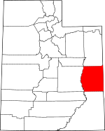
Grand County, Utah Basics:


Grand County Utah - Government Site

Population: 9,347
Area: 3672 square miles
County seat: Moab
Area code(s) in use: 435
Time zone: MST
High school graduate or higher: 87.5%
Bachelor's degree or higher: 25.7%
Median household income: $42,208
Persons in poverty: 13.6%
Home ownership rate: 68.3%
Mean travel time to work: 12.2 minutes


Adjacent counties:
Carbon  Emery  Garfield (CO)  Mesa (CO)  Montrose (CO)  San Juan  Uintah  Wayne  
Find in Utah

Map of the Grand County area


Our detail map of Grand County shows the Grand County, Utah boundary lines and other interesting items.

Places in Grand County, Utah

  Airports     show all on map

Allen Memorial Hospital Heliport, Canyonlands Field Airport, Lemon Airport, Mineral Canyon Strip Airport, Sunbird Airport, Ute Field, Westwater Airport

  Arches     show all on map

Aladdins Lamp Arch, Anniversary Arch, Arch de Triumphe, Arrowhead Arch, Bat Guano Arch, Beckwith Arch, Bench Arch, Black Cave Arch, Box Arch, Box Arch, Broken Arch, Broken Finger Arch, Cliff Arch, Cloister Arch, Clover Canyon Bridge, Coke Oven Arch, Corona Arch, Cove Arch, Crystal Arch, Delicate Arch, Double Arch, Double O Arch, Elephant Arch, Eye of the Whale Arch, Flatiron Arch, Football Arch, Funnel Arch, Gemini Bridges, Gold Bar Arch, Gothic Arch, Hall Bridge, Hole-in-the-Fin Arch, Hole-in-the-Wall, Hunter Arch, Huntress Arch, Indian Head Arch, Jacks Arch, Jewel Tibbetts Arch, Landscape Arch, Little Bridge, Magic Theater Arch, Morning Glory Arch, Navajo Arch, North Window, Ottingers Triple Arch, Oval Canyon Natural Bridge, Parallel Arch, Partition Arch, Piano Leg Arch, Pine Tree Arch, Pinto Arch, Pothole Arch, Pritchett Natural Bridge, Queue Jughandle Arch, Ribbon Arch, Ring Arch, Sand Dune Arch, Schmidt Arch, Shadow Box Arch, Skyline Arch, Slickensides Arch, South Windows, Surprise Arch, Tapestry Arch, The Jug Handle, Top Story Window, Tower Arch, Tunnel Arch, Turban Head Arch, Turret Arch, Twin Arch, Twisted Doughnut Arch, Updraft Arch, Uranium Arch, Wall Arch (historical), Webbing Arch, Window Arch

  Areas     show all on map

Garden of Eden, Herdina Park, Lone Mesa, Maloy Park, Marching Men, Petrified Sand Dunes, Rock Pinnacles, The Biscuits, The Grassies, The Windows Section

  Bars     show all on map

Gold Bar, Nose Bridge

  Basins     show all on map

Bachelor Basin, Beaver Basin, Beaver Hole, Big Hole, Big Hole, Buckhorn Basin, Cub Valley, Gunnison Valley, Hells Hole, Jackson Hole, Kirks Basin, Little Hole, Miners Basin, Nine Hole, Nutters Hole, Richardson Amphitheater, Surveyors Hole, Swedes Hole, The Basin, The Basin, Tom Farrer Valley, Willow Basin

  Benches     show all on map

Bald Mesa, Big Triangle, Coal Canyon Bench, Coal Creek Bench, Corral Canyon Bench, Crescent Bench, Harpole Mesa, Jimmy Keen Flat, Lion Bench, Little Triangle, Poverty Bench, Three Fords Benches

  Bends     show all on map

Beaver Slide Bottom, Big Bend, Bliss Bottom, Hittle Bottom, Horsethief Bottom, Hotel Bottom, Jackson Bottom, Kings Bottom, Lake Bottom, Lake Bottom, McGraw Bottom, Mineral Bottom, Moab Valley, Ninemile Bottom, Point Bottom, Roberts Bottom, Spring Canyon Bottom, Tenmile Bottom, Trin-Alcove Bend, Williams Bottom

  Bridges     show all on map

Courthouse Wash Bridge, Dewey Bridge

  Buildings     show all on map

Castle Valley Fire Department Station 1, Castle Valley Fire Department Station 2, Dan O'Laurie Canyon County Museum, Grand County Courthouse, Grand County Emergency Medical Services, Grand County Public Library, Grand County Sheriff's Office, Moab City Hall, Moab Police Department, Moab Valley Fire Protection District Station 1, Moab Valley Fire Protection District Station 2, Moab Valley Fire Protection District Station 3, Utah Highway Patrol Section 13 Moab Office

  Capes     show all on map

Cnandler Point, Corral Canyon Point, Corral Point, Deadman Point, Horse Point, Mat Martin Point, Mexico Point, Moonwater Point, No Mans Land Point, Split Point, Walker Point, West Point, Westwater Point

  Cemeteries     show all on map

Andy Swenson Gravesite, Elgin Cemetery, Grand Valley Cemetery, Sego Cemetery, Sunset Cemetery, Thompson Cemetery

  Census     show all on map

Thompson Springs Census Designated Place

  Churches     show all on map

Church of God of Prophecy, Community Baptist Church, Espiscopal Church of Saint Francis, First Assembly of God Church, Grace Lutheran Church, Moab Baptist Church, Moab Christian Center, Saint Pius X Catholic Church, Seventh Day Adventist Church, The Church of Jesus Christ of Latter Day Saints, The Church of Jesus Christ of Latter Day Saints, The Church of Jesus Christ of Latter Day Saints

  Cliffs     show all on map

Beaver Slide Rim, Deer Point, Klondike Bluffs, Porcupine Rim, Renegade Point, Spring Creek Point, The Billboard, The Great Wall, Toad Point

  Dams     show all on map

Atlas Mineral Tailings Pond Dam, Crescent Wash Dam, Lake Oowah Dam, Lower Gooseberry Reservoir Dam, Pace Dam, TexasGulf Potash Pond One A Dam, TexasGulf Potash Pond Three A Dam, TexasGulf Potash Pond Three B Dam, TexasGulf Potash Pond Two G Dam, TexasGulf Potash Pond Two N Dam

  Falls     show all on map

Funnel Falls

  Flats     show all on map

Arths Pasture, Bartlett Flat, Big Flat, Courthouse Pasture, Crescent Flat, Crips Hole, Danish Flat, Eagle Park, Elba Flat, Jug Rock Flat, Klondike Flat, May Flat, Pear Park, Sagers Flat, Sand Flat, Spanish Valley, Squaw Park, Squaw Park, Taylor Flat, The Poison Strip, Turper Park, Utah Bottoms, Whipsaw Flat, Wilcox Flat, Willow Flats, Willow Flats, Yellow Cat Flat

  Forests     show all on map

Manti-La Sal National Forest - La Sal Division

  Gaps     show all on map

Burro Pass, Dee Pass, Green River Gap, Red Gap, Thompson Pass

  Hospitals     show all on map

Allen Memorial Hospital, Moab Regional Hospital

  Lakes     show all on map

Beaver Pond, Beaver Ponds, Dead Sheep Pond, Holding Pond, Mud Lake, Strychnine Pond, Tie Pond, Twin Pond

  Locales     show all on map

Arches National Park Visitor Center, Atlas Mineral Plant, Big Sky RV Park, Canyonlands Campark, Castle Rock/Priest and Nuns Point of Interest, Castle Valley Overlook, Castleton, Cato Ranch, Cisco Landing, Cunningham Ranch, Daly, Delicate Arch Viewpoint, Devils Garden Campground, Devils Garden Trailhead, Emkay, Fiery Furnace Viewpoint, Gavin Ranch, Gordon Ranch, Hallet Ranch, Harley Dome, Hatch Ranch, Hill Creek Ranger Station, Hill Creek Youth Camp, Knowles Ranch, La Sal Mountains Viewpoint, McPherson Ranch, Mesa Guard Station, Mill Creek Canyon Overlook, Millers Shopping Center, North Park Avenue Trailhead, Oowah Campground, Panorama Point, Picture Gallery Ranch, Porcupine Ranch, Potash, Revoir Ranch, Richardson, Robidoux Compressor Station, Robidoux Inscription, Ruby Ranch, Salt Valley Overlook, San Arroyo Camp, South Park Avenue Trailhead, Spring Creek Ranch, Stevens Cabin, Titus Ranch, Turnbow Cabin, Valley City, Valley Shopping Center, Warner Campground, Warner Ranger Station, Westwater River Ranger Station and Put In Site, White House, White Ranch, Wolverton Ranch

  Mines     show all on map

Black Ape Mine, Blackstone Incline, Cactus Rat Mine, Crescent Mine, Hey Joe Mine, Jerry Stocks Mine, Johns Incline, Little Eva Mine, Memphis Mines, Parco Mines, Ringtail Mine, Telluride Mines, Yellow Bird Mine

  Oilfields     show all on map

Agate Oil Field, Bar X Gas Field, Book Cliffs Gas Field, Book Cliffs Oil and Gas Field, Bryson Canyon Gas Field, Cisco Springs Gas and Oil Field, Cisco Springs North Gas Field, Danish Wash Gas and Oil Field, Diamond Ridge Gas Field, East Canyon Gas Field, Gravel Pile Oil Field, Harley Dome Gas Field, Horse Point Gas Field, Overlook Gas Field, Pear Park Gas Field, San Arroyo Gas Field, Stateline Gas Field, Westwater Gas Field

  Parks     show all on map

Arches National Park, Dead Horse Point State Park, Dead Horse Point State Park, Fisher Towers Picnic Area, Lions Park, Moab KOA, Moose Park, Old City Park, Pinhook Draw Historical Marker, Slickrock Country Camp

  Pillars     show all on map

Adam and Eve, Balanced Rock, Buccaneer Rock, Castle Rock, Courthouse Towers, Dark Angel, Determination Towers, Devils Garden, Devils Golf Ball, Duck-on-the-Rock, Fiery Furnace, Fisher Towers, Ham Rock, Jacks Mummy, Owl Rock, Parade of Elephants, Priest and Nuns, Queen Nefertiti Rock, Queen Victoria Rock, Rock Settee, Sausage Rock, Sheep Rock, The Lovers, The Organ, The Phallus, The Poodle, The Titan, Three Gossips, Totem Pole

  Plains     show all on map

Dome Plateau

  Populated Places     show all on map

Agate, Brendel, Castle Valley, Cisco, Cottonwood, Crescent Junction, Dewey, Elba, Elgin, Floy, Moab, Sagers, Sego, Solitude, Thompson Springs, Three Pines, Vista, Westwater

  Post Offices     show all on map

Basin Post Office (historical), Moab Post Office, Wilson Post Office (historical)

  Ranges     show all on map

McPherson Range

  Rapidss     show all on map

Coal Creek Rapids, Curry Rapids, J L Eddy, Joe Hutch Canyon Rapids, Last Chance Rapids, Moonwater Rapids, New Rapids, Onion Creek Rapids, Professor Creek Rapids, Red Point Rapids, Rocky Rapids, Saleratus Rapids, Salt Wash Rapids, Skull Rapids, Sock-It-To-Me Rapids, Stateline Rapids, White Rapids

  Reservoirs     show all on map

Atlas Mineral Tailings Reservoir, Big Flat Reservoir, Blue Flat Reservoir, Crescent Wash Reservoir, Dons Lake, Hidden Lake, Jackson Reservoir, Lake Oowah, Pace Lake, Rock Corral Reservoir, Tenmile Wash Reservoir, Valley City Reservoir, Warner Lake, Weaver Reservoir, Yellow Cat Reservoir

  Ridges     show all on map

Amasa Back, Black Horse Ridge, Blue Hills, Bryson Ridge, Cedar Camp Ridge, Cedar Ridge, Christmas Ridge, Deadman Point, Diamond Ridge, Horse Ridge, Horsethief Point, Little Creek Ridge, Mineral Point, Moon Ridge, Mormon Ridge, Overlook Ridge, Picket Corral Ridge, Post Canyon Ridge, Saddle Ridge, San Arroyo Ridge, Sinbad Ridge, Snowshoe Ridge, Spring Canyon Point, Spring Creek Ridge, Steer Ridge, Steer Ridge, Steer Ridge, Tenmile Point, Trough Spring Ridge, Wagon Road Ridge, Went Ridge, Winter Camp Ridge

  Schools     show all on map

Grand County Middle School, Grand High School, Red Rock School, Seventh Day Adventist School

  Springs     show all on map

Anna Laura Spring, Auger Spring, Big Spring, Bolon Spring, BP Spring, Brink Spring, Buck Spring, Burro Seep, Cane Spring, Cato Springs, Caves Spring, Cedar Camp Spring, Chicken Spring, Cisco Springs, Clark Spring, Cold Spring, Cottonwood Spring, Courthouse Spring, Cow Spring, Cowskin Spring, Crib Spring, Crystal Geyser, Crystal Spring, Cub Spring, Deadman Spring, Dewey Spring, Dripping Spring, Dry Oak Spring, Florence Spring, Freshwater Spring, Goat Spring, Hogan Spring, Horseshoe Spring, Horsethief Spring, Jack Spring, Kelly Spring, King Bottom Spring, Little Mountain Spring, Little Mountain Spring, Lost Spring, Lower Courthouse Spring, Marble Spring, Marys Water, Mason Spring, Matrimony Spring, Moonwater Springs, Mud Spring, Oak Spring, Oak Springs, Oak Springs, P R Spring, Peterson Spring, Pinto Springs, Pioche Spring, Post Canyon Spring, Red Spring, Red Spring, Rock Spring, Salt Spring, Salt Spring, Seeley Spring, Shale Spring, Showerbath Spring, Slough Canyon Spring, Stinking Spring, Table Rock Spring, Tar Bucket, Tom Spring, Trough Spring, West Spring, Wilcox Spring, Willow Spring

  Streams     show all on map

Bar A Creek, Bear Creek, Beaver Creek, Bitter Creek, Bluebell Creek, Castle Creek, Chicken Fork, Clear Creek, Coach Creek, Coal Creek, Coates Creek, Corral Creek, Corral Creek, Cow Creek, Deep Creek, Dolores River, Dry Fork, Dry Fork, Dry Fork, Dry Fork, Dry Fork, Dry Fork Mill Creek, East Fork Bitter Creek, East Fork Little Creek, East Willow Creek, Fish Creek, Fisher Creek, Florence Creek, Granite Creek, Harris Fork, Joe Hutch Creek, Left Hand Fish Creek, Little Creek, Little Dolores River, Mason Spring Creek, Meadow Creek, Middle Fork Bitter Creek, Mill Creek, North Fork Mill Creek, Onion Creek, Pack Creek, Pinhook Creek, Pioche Creek, Placer Creek, Potato Creek, Professor Creek, Renegade Creek, Right Hand Fish Creek, Rill Creek, Ryan Creek, Spring Branch, Spring Creek, Spring Creek, Spring Creek, Stearns Creek, Sulphur Creek, Taylor Creek, Tenmile Wash, Thompson Wash, Webb Hollow Creek, West Fork Bitter Creek, West Fork Hill Creek, West Willow Creek, Westwater Creek, Wet Fork Mill Creek

  Summits     show all on map

Adobe Mesa, Andy Mesa, Bear Trap Knoll, Beehive Butte, Big Pinto Mesa, Black Knolls, Blue Chief Mesa, Boren Mesa, Boulder Mesa, Bread Knolls, Buckhorn Mesa, Cherry Mesa, Cisco Mesa, Coffee Pot Rock, Cottonwood Point, Courthouse Rock, Cowhead Hill, Crescent Butte, Dellenbaugh Butte, Dolores Point, Dry Mesa, Duma Point, Elephant Butte, Fisher Mesa, Flatiron Hill, Gold Knob, Grand View, Hat Rock, Hatch Mesa, Hill Creek Point, Horse Mesa, Horse Mountain, Hotel Mesa, Johnsons Up on Top, Jug Rock, Jumping Off Point, La Sal Peak, Little Pinto Mesa, Manns Peak, Memphis Hill, Merrimac Butte, Mollie Hogans, Monitor Butte, Mount Nass, Mount Tomasaki, Mount Waas, Mule Shoe, North Beaver Mesa, Parriott Mesa, Pinnacle Mesa, Poison Spider Mesa, Polar Mesa, Post Canyon Point, Potato Hill, Ray Mesa, Roan Peaks, Roberts Mesa, Rock Spring Mesa, Round Mountain, Santio Knolls, Scharf Mesa, Sevenmile Mesa, Sevenmile Mesa, Slough Canyon Point, Snyder Mesa, South Beaver Mesa, South Mesa, Steamboat Mesa, Suluar Mesa, Survey Point, Taylor Point, Tenmile Butte, Tenmile Knoll, Tepee Point, The Highlands, The Knoll, The Needles, The Portal, Three Penguins, Titan Tower, Tombstone Butte, Tower of Babel, Whitbeck Rock, Wilcox Point, Wilson Mesa, Windy Mesa, Windy Point, Yellow Cat Mesa

  Towers     show all on map

KKLX-FM (Moab), KKLX-FM (Moab), KURA-AM (Moab)

  Trails     show all on map

Delicate Arch Trail, Horsethief Trail, Moab Slickrock Trail, Sunrise Dugway, Sunset Dugway

  Valleys     show all on map

Agate Wash, Agate Wash, Antone Canyon, Antone Wash, Ballard Draw, Bar X Canyon, Bar X Wash, Bartlett Wash, Bear Canyon, Beaver Canyon, Big Hole Wash, Billie Brown Canyon, Black Canyon, Blaze Canyon, Bobby Canyon, Bogart Canyon, Bootlegger Canyon, Bootlegger Wash, Bridge Canyon, Browns Wash, Brusher Canyon, Bryson Canyon, Bryson Wash, Buck Canyon, Buck Canyon, Buck Canyon Wash, Buckhorn Draw, Bull Canyon, Bull Canyon, Bull Canyon, Bull Canyon, Bull Canyon, Bull Canyon, Bunchground Canyon, Burkholder Draw, Burnt Draw, Burro Canyon, Butler Canyon, Cache Valley, Cache Valley Wash, Cain Hollow, Cain Hollow, Calf Canyon, Castle Valley, Cedar Camp Canyon, Cherry Canyon, Cherry Canyon, Cisco Wash, Clover Canyon, Coal Canyon, Coal Canyon, Coal Draw, Corral Canyon, Corral Canyon, Corral Canyon Wash, Corral Wash, Cottonwood Canyon, Cottonwood Canyon, Cottonwood Canyon, Cottonwood Canyon, Cottonwood Canyon, Cottonwood Wash, Cottonwood Wash, Courthouse Wash, Cove of Caves, Cow Canyon, Cow Canyon, Cow Canyon, Crescent Canyon, Crescent Wash, Crooked Wash, Danish Wash, Dark Canyon, Day Canyon, Day Canyon, Death Valley, Deep Canyon, Diamond Canyon, Drinks Canyon, Dripping Springs Canyon, Dry Canyon, Dry Canyon, Dry Canyon Wash, Dry Fork Bull Canyon, Dry Gulch, Dry Wash, Dubinky Wash, Dugout Wash, East Canyon, East Fork Chandler Canyon, Fin Canyon, Fish Seep Draw, Fisher Valley, Fivemile Canyon, Flat Nose George Canyon, Floy Canyon, Floy Wash, Flume Canyon, Freckles Canyon, Freckles Canyon, Gold Bar Canyon, Gray Canyon, Hal Canyon, Halfway Canyon, Harmes Canyon, Hay Canyon, Hell Roaring Canyon, Hellroaring Canyon, Hells Hole Canyon, Hells Hole Canyon, Hey Joe Canyon, Hideout Canyon, Hideout Canyon, Horse Canyon, Horse Canyon, Horse Canyon, Horse Canyon, Horse Canyon, Horse Heaven, Hunt Canyon, Hunters Canyon, Ice Canyon, Ida Gulch, Jackass Canyon, Jennie Canyon, Jim Canyon, Jim Canyon, Jones Canyon, Jones Canyon, Kelly Canyon, Klondike Wash, Laplan Canyon, Left Fork Naylon Canyon, Left Hand Bull Canyon, Left Hand Nash Wash, Left Hand Threeforks Floy Canyon, Left Hand Tusher Canyon, Line Canyon, Lion Canyon, Little Berry Canyon, Little Canyon, Little Grand Wash, Little Jim Canyon, Little Valley, Little Valley, Little Valley, Long Canyon, Long Canyon, Long Canyon, Long Canyon Wash, Long Valley, Lost Spring Canyon, Lower Bear Canyon, Lower Twin Canyon, Marble Canyon, Mary Jane Canyon, Mason Draw, Maverick Canyon, Middle Canyon, Middle Crescent Canyon, Middle Horse Canyon, Mill Canyon, Mine Draw, Mineral Canyon, Miners Basin, Moab Canyon, Monument Wash, Moon Ridge Canyon, Moonwater Canyon, Nash Wash, Naylon Canyon, Negro Bill Canyon, Nelson Draw, North Fork Mineral Canyon, One Eye Canyon, Owl Draw, Park Avenue, Pine Canyon, Pinhook Valley, Pinto Canyon, Pinto Wash, Pipeline Canyon, Pole Canyon, Pole Canyon, Porcupine Canyon, Porcupine Draw, Post Canyon, Poverty Canyon, Preacher Canyon, Pritchett Canyon, Professor Valley, Rattlesnake Canyon, Red Wash, Renegade Canyon, Renegade Draw, Right Fork Naylon Canyon, Right Hand Bull Canyon, Right Hand Crescent Canyon, Right Hand Horse Canyon, Right Hand Thompson Canyon, Right Hand Threeforks Floy Canyon, Right Hand Tusher Canyon, Rock Spring Canyon, Rough Canyon, Ryans Gulch, Sagers Canyon, Sagers Wash, Saleratus Canyon, Saleratus Wash, Sallys Hollow, Salt Valley, Salt Valley Wash, Salt Wash, Salt Wash, San Arroyo, San Arroyo Canyon, San Arroyo Wash, Sego Canyon, Segundo Canyon, Sevenmile Canyon, Sevenmile Canyon, She Canyon, Short Canyon, Showerbath Canyon, Shuman Gulch, Sids Draw, Slough Canyon, Snowshoe Canyon, Solitude Wash, South Fork Mineral Canyon, South Fork Sevenmile Canyon, Spring Canyon, Spring Canyon, Spring Canyon, Spring Wash Canyon, Spruce Canyon, Star Canyon, Steer Gulch, Strychnine Wash, Stub Canyon, Sulphur Canyon, Supply Canyon, Taylor Canyon, Tenmile Canyon, Tenmile Canyon, Tepee Canyon, The Narrows, Thompson Canyon, Thompson Canyon, Three Fords Canyon, Trail Canyon, Trail Canyon, Trail Canyon, Trail Canyon, Trail Canyon, Trap Canyon, Triangle Canyon, Tub Canyon, Tusher Canyon, Tusher Canyon, Tusher Wash, Upper Bear Canyon, Upper Twin Canyon, Ute Canyon, Walker Draw, Waring Canyon, Well Hollow, Westwater Canyon, White Wash, Wild Cow Wash, Wildcow Canyon, Winter Camp Canyon, Winter Camp Draw, Winter Camp Wash, Yellow Cat Wash, Yellow Jacket Canyon

  Wells     show all on map

Bitter Creek Well, Cedar Ridge Well, Dalton Well, Dubinky Well, Levi Well, Queens Well

  Woods     show all on map

The Pines,

Grand County, Utah Population By Race (2012 estimate)

RacePopulation
WhiteGrand County White population 8,6278,627  
American IndianGrand County American Indian population 402401
MixedGrand County Mixed population 178177
AsianGrand County Asian population 8484
BlackGrand County Black population 5656
Hawaiian & Pacific IslanderGrand County Hawaiian & Pacific Islander population 99

Additional population tables :
State population table
Utah population by county