Morgan County, Utah Basics:


Morgan County Utah - Government Site

Population: 9,812
Area: 609 square miles
County seat: Morgan
Area code(s) in use: 801
Time zone: MST
High school graduate or higher: 97.3%
Bachelor's degree or higher: 29.1%
Median household income: $77,159
Persons in poverty: 5.1%
Home ownership rate: 87.9%
Mean travel time to work: 25.7 minutes
Adjacent counties:
Davis  Rich  Salt Lake  Summit  Weber  

Find in Utah

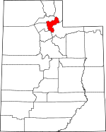
Map of the Morgan County area


Our detail map of Morgan County shows the Morgan County, Utah boundary lines and other interesting items.

Places in Morgan County, Utah

  Airports     show all on map

Francis Peak Heliport, Morgan County Airport

  Basins     show all on map

Strawberry Bowl, The Valleys, Weed Basin

  Buildings     show all on map

Francis Peak Pumping Station, Morgan County Ambulance, Morgan County Fire Department, Morgan County Sheriff Department, Mountain Green Fire Department

  Canals     show all on map

Enterprise Ditch, Gateway Canal, North Morgan Canal, Northwest Bench Ditch

  Cemeteries     show all on map

Croydon Cemetery, Milton Cemetery, Mountain Green Cemetery, North Morgan Cemetery, Peterson Cemetery, Porterville Cemetery, Richville Cemetery, South Morgan Cemetery

  Census     show all on map

Enterprise Census Designated Place, Mountain Green Census Designated Place

  Churches     show all on map

Morgan County Community Church, The Church of Jesus Christ of Latter Day Saints, The Church of Jesus Christ of Latter Day Saints, The Church of Jesus Christ of Latter Day Saints, The Church of Jesus Christ of Latter Day Saints, The Church of Jesus Christ of Latter Day Saints

  Dams     show all on map

Como Diversion, East Canyon Dam, Lost Creek Dam, Richville Diversion Dam, Stoddard Diversion Dam

  Flats     show all on map

Big Flat, Tom Condies Flat

  Forests     show all on map

Wasatch-Cache National Forest

  Gaps     show all on map

Big Mountain Pass, The Narrows, The Narrows

  Guts     show all on map

Stoddard Slough

  Lakes     show all on map

Smith Creek Lakes

  Locales     show all on map

East Canyon Campground, Francis Peak Overlook, Gateway, Grants Grave, Lost Creek Campground, Macfarlane Ranch, Site of Dixie Hollow Pony Express Station

  Mines     show all on map

Robinson Mine, Strawberry Mine

  Parks     show all on map

Bauchmanns Pony Express Station Historical Marker, Camp Clayton Historical Marker, East Canyon State Park, Lost Creek State Park, Mormon Flat Historical Marker, Round Valley Wildlife Management Area

  Pillars     show all on map

China Town, Swallow Rocks

  Populated Places     show all on map

Como Springs, Croydon, Devils Slide, Enterprise, Littleton, Milton, Morgan, Mountain Green, Peterson, Polls, Porterville, Richville, Stoddard, Taggarts, Whites Crossing

  Post Offices     show all on map

Morgan Post Office

  Reservoirs     show all on map

East Canyon Reservoir, Lost Creek Reservoir, Northwest Reservoir, Wilkinson Reservoir

  Ridges     show all on map

Blue Ridge, Condie Ridge, Folley Ridge, Gold Ridge, Horse Ridge, Horse Ridge, Mahogany Ridge, Rocky Ridge, Stark Ridge, The Hogsback

  Schools     show all on map

Morgan High School, Morgan Middle School, Morgan School

  Slopes     show all on map

Devils Slide

  Springs     show all on map

Bear Spring, Clark Spring, Cold Spring, Dixie Hollow Springs, Dixie Spring, Durst Spring, Folley Spring, Oak Spring, Rock Spring, Sulphur Springs, Tom Porter Springs, Trout Springs, Warner Spring, Willow Spring, Willow Spring, Yellowjacket Spring, Yellowstone Spring

  Streams     show all on map

Arthurs Fork, Beaver Creek, Beaver Creek, Belnap Creek, Big Cottonwood Creek, Big Fork, Big Pine Fork, Big Tree Creek, Blue Fork Creek, Bull Nelson Creek, Bybee Creek, Center Fork Deep Creek, Cordwood Creek, Cottonwood Creek, Dalton Creek, Deep Creek, Dry Creek, Dry Creek, Dry Fork, Dry Pine Creek, Durst Creek, East Canyon Creek, Enterprise Slough, Farrells Creek, Freestone Creek, Gorder Creek, Gordon Creek, Hardscrabble Creek, Hunts Meadow Creek, Jacobs Creek, Killfoil Creek, Layton Creek, Left Fork Deep Creek, Left Fork Shingle Mill Creek, Left Hand Fork Arthurs Creek, Left Hand Fork Dalton Creek, Left Hand Fork Peterson Creek, Line Creek, Little Cottonwood Creek, Little Pine Fork, Little Trail Creek, Lost Creek, Maggie Hopkins Cottonwood Creek, Middle Fork Arthurs Creek, Middle Fork Peterson Creek, Monument Creek, Monument Creek, North Fork Deep Creek, Peterson Creek, Quaking Asp Creek, Quarry Cottonwood Creek, Right Fork Dry Creek, Right Fork Shingle Mill Creek, Right Hand Fork Arthurs Creek, Right Hand Fork Bybee Creek, Right Hand Fork Coal Hollow, Right Hand Fork Dalton Creek, Right Hand Fork Peterson Creek, Sawmill Creek, Sawtooth Creek, Schuster Creek, Schuster Creek, Sheep Creek, Shingle Mill Creek, Smith Creek, South Fork Line Creek, Spring Branch, Squaw Creek, Strawberry Creek, Taylor Creek, Tom Condies Creek, Trail Creek, Walton Creek, Wet Fork Schuster Creek, Woods Creek

  Summits     show all on map

Big Mahogany Mountain, Big Mountain, Bolly Knob, Bybee Knoll, Durst Mountain, Elk Mountain, Goat Knoll, Guilder Peak, Haystack Mountain, Herd Mountain, Hogback Summit, Hoodoo Knoll, Little Mahogany Mountain, Middle Peak, Nielsons Peak, Porcupine Peak, Saddle Rock, The Head, Thurston Peak, Windy Knoll

  Trails     show all on map

Route of Donner-Reed Party and Mormon Pioneers

  Valleys     show all on map

Arbuckle Canyon, Beaver Canyon, Beaver Dam Hollow, Berry Gulch, Big Buck Canyon, Big Dutch Hollow, Big Hollow, Black Gulch, Black Hawk Canyon, Blue Bell Hollow, Bohman Hollow, Boiler Hollow, Box Canyon, Branch Canyon, Brewer Canyon, Broad Hollow, Brushy Canyon, Buck Canyon, Bybee Gulch, Cabin Hollow, Cataract Canyon, Cedar Canyon, Cedar Canyon, Chokecherry Hollow, Coal Hollow, Coal Hollow, Cooper Gulch, Corral Canyon, Cottonwood Canyon, Cottonwood Canyon, Cottonwood Canyon, Coyote Canyon, Coyote Canyon, Coyote Hollow, Dead Ox Canyon, Deadman Gulch, Deep Canyon, Deer Fly Hollow, Deer Hollow, Devils Hollow, Devils Hollow, Dip Hollow, Dirty Hollow, Dixie Hollow, Doc Dorlands Hollow, Dry Canyon, Dry Hollow, Dry Hollow, Dry Hollow, Dry Hollow, East Canyon, Fawn Hollow, First Hollow, Folley Canyon, Francis Canyon, Frank Hollow, Geary Hollow, Grassy Canyon, Guildersleeve Canyon, Hay Hollow, Hell Canyon, Henholt Canyon, Hillman Hollow, Hornet Gulch, Horseshoe Canyon, Howard Hollow, Ivory Fork, Joe Durrant Hollow, Joe Hollow, Jones Hollow, Kurzy Hollow, Lake Canyon, Left Fork Beaver Canyon, Left Fork Guilder Sleeve Canyon, Left Fork Little Dutch Hollow, Left Fork Taylor Hollow, Left Hand Fork Coal Hollow, Little Brewer Canyon, Little Buck Canyon, Little Deer Hollow, Little Dutch Hollow, Little Emigration Canyon, Little Hollow, Little Peck Canyon, Long Hollow, Long Hollow, Lost Valley, Mahogany Canyon, Metz Hollow, Middle Fork Coal Hollow, Middle Fork Guilder Sleeve Canyon, Miller Gulch, Mine Hollow, Mine Hollow, Morgan Valley, Norwood Canyon, Oak Spring Canyon, Paradise Canyon, Peck Canyon, Petes Canyon, Phil Shop Hollow, Pine Canyon, Pine Canyon, Pine Canyon, Pipe Hollow, Pole Hollow, Pole Hollow, Powder Hollow, Priest Hollow, Quaking Aspen Hollow, Quarry Cottonwood Canyon, Quarry Hollow, Rabbit Hollow, Raymonds Hollow, Red Cedar Canyon, Red Hollow, Redrock Canyon, Right Fork Beaver Canyon, Right Fork Guilder Sleeve Canyon, Right Fork Taylor Hollow, Right Hand Fork Norwood Canyon, Right Hand Fork Roswells Canyon, Right Hand Fork Sheep Canyon, Road Hollow, Rocky Canyon, Rocky Canyon, Rocky Hollow, Roswells Canyon, Rough Canyon, Round Valley, Sharps Hollow, Sheep Canyon, Shells Hollow, Soldier Canyon, South Fork Francis Canyon, Spring Canyon, Spring Hollow, Spring Hollow, Spring Hollow, Spring Hollow, Spring Hollow, Spring Hollow, Stoddard Canyon, Stokes Canyon, Taggart Hollow, Taylor Hollow, The Gulch, Tom Adams Hollow, Tom Condies Hollow, Tonks Canyon, Toone Canyon, Trough Hollow, Tucker Hollow, Tucson Hollow, Tunnel Hollow, Turner Canyon, Upper Weber Canyon, Wheatgrass Canyon, Wheatgrass Hollow, Wide Canyon, Willow Hollow, Wolf Den Canyon, Yence Hollow,

Morgan County, Utah Population By Race (2012 estimate)

RacePopulation
WhiteMorgan County White population 9,6069,605  
MixedMorgan County Mixed population 8888
AsianMorgan County Asian population 4949
American IndianMorgan County American Indian population 3939
BlackMorgan County Black population 2019
Hawaiian & Pacific IslanderMorgan County Hawaiian & Pacific Islander population 109

Additional population tables :
State population table
Utah population by county