Wasatch County, Utah Basics:


Wasatch County Utah - Government Site

Population: 25,311
Area: 1176 square miles
County seat: Heber City
Area code(s) in use: 435
Time zone: MST
High school graduate or higher: 90.4%
Bachelor's degree or higher: 31.3%
Median household income: $65,012
Persons in poverty: 8.2%
Home ownership rate: 76.8%
Mean travel time to work: 24.6 minutes
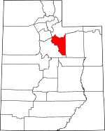
Adjacent counties:
Duchesne  Salt Lake  Summit  Utah  

Find in Utah

Map of the Wasatch County area


Our detail map of Wasatch County shows the Wasatch County, Utah boundary lines and other interesting items.

Places in Wasatch County, Utah

  Airports     show all on map

Heber City Municipal Airport - Russ McDonald Field, Rocky Mountain Helicopters Incorporated Heliport (historical), Wasatch County Hospital Heliport

  Areas     show all on map

Beef Pasture

  Basins     show all on map

Bear Hole, Becky Basin, Bills Basin, Boulder Basin, Buck Basin, Coleman Basin, Devils Hole, Jimmies Basin, Jones Basin, Little Valley, Neeley Basin, Roundy Basin, Sandstone Basin, Scotty Basin, Smith Basin, Soapstone Basin, Strawberry Valley, The Cove, Tims Hole

  Benches     show all on map

Balsam Bench, Row Bench, Weeks Bench

  Buildings     show all on map

Harold P Fabian Visitor Center, Heber City Police Department, Heber Valley Railroad Depot, Jordanelle Fire Station, Midway Town Hall, Utah Highway Patrol Section 7 Heber Office, Wasatch County Emergency Medical Services, Wasatch County Fire District Heber City, Wasatch County Fire District Jordanelle, Wasatch County Fire District Midway, Wasatch County Fire District Wallsburg, Wasatch County Sheriff's Office

  Canals     show all on map

Boren Ditch, Currant Creek Feeder Canal, Currant Tunnel, Epperson Ditch, Highline Canal, Humbug Canal, Indian Creek Diversion Canal, Island Ditch, Layout Tunnel, Lower Charleston Canal, Middle Ditch, North Ditch, River Ditch, Sagebrush and Spring Creek Canal, Strawberry Ditch, Timpanogos Canal, Upper Charleston Canal, Vat Tunnel, Wasatch Canal, Water Hollow Tunnel, West Bench Ditch, Westside Ditch, Willow Creek Ditch

  Capes     show all on map

Chaplain Point, Haws Point, Renegade Point

  Cemeteries     show all on map

Center Creek Cemetery, Charleston Cemetery, Heber City Cemetery, Midway City Cemetery, Mound City Cemetery, Wallsburg Cemetery, William Walter Wilson Burial Site

  Census     show all on map

Heber Division, Timber Lakes Census Designated Place

  Churches     show all on map

First Baptist Church, Heber Valley Baptist Church, Heber Valley Bible Church, Mountain Valley Baptist Chapel, Saint Lawrence Catholic Church, The Church of Jesus Christ of Latter Day Saints, The Church of Jesus Christ of Latter Day Saints, The Church of Jesus Christ of Latter Day Saints, The Church of Jesus Christ of Latter Day Saints, The Church of Jesus Christ of Latter Day Saints, The Church of Jesus Christ of Latter Day Saints, The Church of Jesus Christ of Latter Day Saints, The Church of Jesus Christ of Latter Day Saints, The Church of Jesus Christ of Latter Day Saints

  Cliffs     show all on map

Red Ledge, Red Ledge, The Jumpoff, White Ledge

  Dams     show all on map

Barnes Reservoir Dam, Bennett Lindsay Lower Dam, Center Creek Number Five Dam, Center Creek Number One Dam, Center Creek Number Three Dam, Center Creek Number Two Dam, Clyde Lake Dam, Currant Creek Dam, Dee Mills Dam, Deer Creek Dam, Deer Valley Dam, Jones Dam, Jordanelle Dam, Kenneth Anderson Dam, Lost Lake Dam, Mill Hollow Dam, Silver Lake Dam, Silver Lake Islet Dam, Soldier Creek Dam, Strawberry Dam (historical), Witts Lake Dam

  Falls     show all on map

Smooth Rock Falls

  Flats     show all on map

Big Flat, Big Glade, Bonanza Flat, Broadhead Meadows, Broadwater Meadows, Cummings Flat, Dock Flat, Dockweed Flat, Harvey Meadow, Mill B Flat, Mill Flat, Silver Meadow, Wing Flat

  Gaps     show all on map

Bobby Duke Pass, Daniels Pass, Low Pass, Pole Line Pass, Sandy Baker Pass, Soapstone Pass, The Narrows

  Hospitals     show all on map

Heber Valley Medical Center, Wasatch County Hospital (historical)

  Lakes     show all on map

Blizzard Lake, Blue Lake, Broadhead Lake, Iron Mine Lake, Joan Lake, Lackawaxen Lake, Lake Brimhall, Yellow Lake

  Levees     show all on map

Indian Bay Dike (historical)

  Locales     show all on map

Aspen Grove Campground, Avintaquin Guard Station, Badger Point Campground, Bald Mountain Overlook, Bear Camp, Bryants Fork Campground (historical), Bryants Fork Guard Station, Camp Roger, Camp Strawberry, Chaplain Point Day Use Area, Chaplain Point Fisherman Access, Charleston, Chicken Creek Day Use Area, Chicken Creek Day Use Area, Chicken Creek Day Use Area, Clarks Camp, Cloud Rim Girl Scout Camp, Cobblerest Campground, Cow Camp, Currant Creek Campground, Currant Creek Guard Station, Daniels Ranch (historical), Deer Creek Campground, Diving Rock Fisherman Access, East Portal, Haws Point Day Use Area, Hogsback Exclosure, Hub Guard Station, Keetley Station, Lodge Pole Campground, Lost Creek Campground, Midway Fish Hatchery, Mill Hollow Campground, Mill Hollow Guard Station, Moymer Cabin, Mud Creek Fisherman Access, Murdock Powerhouse, Nobletts Administrative Site, Oakcrest Camp, Piuta Camp, Provo River Falls Overlook, Racetrack Campground, Renegade Point Campground, Sage Creek Fisherman Access, Soapstone Guard Station, Soldier Creek Bay Fisherman Access, Soldier Creek Campground, Soldier Creek Overlook, Strawberry Administrative Site, Strawberry Bay Campground, Upper Provo Bridge Picnic Area, West Portal Fisherman Access, Whiskey Spring Picnic Area, Willow Creek Guard Station, Wolf Creek Campground

  Mines     show all on map

Cunningham Tunnel, East Ontario, East Utah Shaft, Flagstaff Mine, Glencoe Mine, Hawkeye McHenry, Jones Shaft, Keeler Tunnel, Mayflower Mine, McCune Tunnel, Park Heber Tunnel, Park King, Park Konold, Park Premier Shaft, Queen Tunnel, Star Tunnel, Steamboat Tunnel, Valeo Mine, Wasatch

  Parks     show all on map

Deer Creek State Park, Jordanelle State Park, Soldier Creek Dam Day Use Area, Soldier Creek Recreation Complex, Strawberry Bay Recreation Complex, Strawberry River Day Use Area, Wallsburg Wildlife Management Area, Wasatch Mountain State Park

  Populated Places     show all on map

Bryants Fork Summer Home Area, Center Creek, Charleston, Cranmer, Daniel, Hailstone, Heber City, Hideout, Independence, Jordanelle, Keetley, Midway, Mound City, Mountain Spa, Parkview Trailer Court, Soapstone Summer Home Area, Soldier Summit, Three Forks, Timber Lakes, Wallsburg

  Post Offices     show all on map

Heber City Post Office, Midway Post Office, Wallsburg Post Office

  Reservoirs     show all on map

Barnes Reservoir, Bloods Lake, Bown Corral Reservoir, Center Creek Number Five Reservoir, Center Creek Number One Reservoir, Center Creek Number Three Reservoir, Center Creek Number Two Reservoir, Clyde Lake, Currant Creek Reservoir, Dee Mills Reservoir, Deer Creek Reservoir, Deer Valley Reservoir, Harris Reservoir, Heart Lake, Jones Reservoir, Jordanelle Reservoir, Kenneth Anderson Reservoir, Little Pond, Lower Bennett Lindsay Reservoir, Midway Reservoir, Mill Hollow Reservoir, Silver Lake, Silver Lake Islet, Soldier Creek Reservoir, Strawberry Reservoir, Trail Reservoir, Witts Lake

  Ridges     show all on map

Bobby Duke Ridge, Buck Hollow Ridge, Coyote Ridge, Donkey Ridge, Duchesne Ridge, Flat Ridge, Hogsback Ridge, Poison Ridge, Shale Ridge, Strawberry Ridge, Trail Ridge, Trout Creek Ridge, Twelve Hundred Dollar Ridge, Vat Creek Ridge, Wallsburg Ridge, Willow Creek Ridge, Windy Ridge

  Schools     show all on map

Central Elementary School, J R Smith Elementary School, Midway Elementary School, Midway School, Mill Hollow Granite School Center, North Kindergarten School, Wasatch County High School, Wasatch High School, Wasatch Middle School

  Springs     show all on map

Balsam Spring, Banjo Spring, Big Beaver Springs, Big Flat Spring, Big Spring, Big Spring, Bowen Spring, Box Spring, Buck Spring, Bull Spring, Burnt Stump Spring, Cabin Spring, Canyon Spring, Cascade Springs, Chicken Spring, Chicken Spring, Circle Spring, Cold Spring, Cold Spring, Decker Spring, Epperson Spring, Flat Ridge Spring, Foreman Spring, Gerber Spring, Grassy Spring, Indian Spring, Indian Spring, Indian Spring, Indian Spring, Lake Spring, Little Red Spring, Mahogany Spring, Mair Spring, Moynier Spring, Mud Spring, Mule Ear Spring, Second Set Spring, Shady Spring, Shingle Spring, Soldier Springs, Stinking Springs, Sulphur Spring, Tooth Spring, Trail Spring, Warm Ditch Spring, Warm Spring, Willow Spring

  Streams     show all on map

Annie Mae Creek, Balsam Creek, Beaver Creek, Bench Creek, Berkenshaw Creek, Brumley Creek, Bryants Fork, Buckboard Creek, Center Creek, Chicken Creek, Chipman Creek, Clyde Creek, Co-op Creek, Cobble Creek, Crooked Creek, Crooked Creek, Daniels Creek, Decker Creek, Deep Creek, Drain Tunnel Creek, East Fork Little Sand Creek, East Twin Creek, Glen Cabin Creek, Hildas Basin Creek, Hobble Creek, Horse Creek, Indian Creek, Iron Mine Creek, Iron Mine Creek, Johnson Fork, Jones Cabin Creek, Lake Creek, Lake Fork, Lavina Creek, Left Fork Currant Creek, Left Fork Little Hobble Creek, Left Fork Little Red Creek, Left Fork White River, Little Co-op Creek, Little Hobble Creek, Little Red Creek, Little Sand Creek, Little South Fork Provo River, Little West Fork, Low Pass Creek, Lundeen Creek, Main Creek, Maple Creek, Middle Fork White River, Mud Creek, Nobletts Creek, North Fork Deep Creek, North Fork Phelps Brook, Pass Creek, Pass Creek, Penrod Creek, Pine Creek, Provo Deer Creek, Racetrack Creek, Red Pine Creek, Red Pine Creek, Right Fork Currant Creek, Right Fork Little Hobble Creek, Right Fork Little Red Creek, Right Fork White River, Rock Creek, Ross Creek, Sage Creek, Schoolhouse Creek, Snake Creek, Soapstone Creek, Soldier Creek, South Bench Creek, South Fork Currant Creek, South Fork Deer Creek, South Fork Phelps Brook, South Fork Provo River, Spring Creek, Spring Creek, Squaw Creek, Streeper Creek, Trout Creek, Tut Creek, Twin Creek, Vat Creek, West Fork Little Sand Creek, West Twin Creek, Wheeler Fork, Whipstock Creek, Willow Creek, Willow Creek, Willow Creek, Willow Spring Creek, Wolf Creek

  Summits     show all on map

Ant Knolls, Bald Eagle Mountain, Bald Knoll, Bald Mountain, Baldy Mountain, Buck Knoll, Buckhorn Knoll, Burgi Hill, Clayton Peak, Currant Creek Peak, Doe Knoll, Green Knoll, Gremo Hill, Heber Mountain, Homestead Crater Mineral Dome, Iron Mine Mountain, Island Mountain, Jimmies Point, Little Baldy Mountain, Lone Hill, Memorial Hill, Middle Mountain, Mill Canyon Peak, Mount Cardwell, Phosphate Hill, Potters Knoll, Raspberry Knoll, Red Creek Mountain, Soapstone Mountain, Square Top Mountain, Strawberry North Summit, Strawberry Peak, Strawberry Peak, Sunset Peak, The Knolls, The Peak, Twin Peaks, Wolf Creek Peak, Wolf Creek Summit

  Towers     show all on map

KLVR-AM (Heber City)

  Trails     show all on map

Littles Fork Trail, Nobletts Creek Trail, Soldier Creek Campground Loop Trail

  Tunnels     show all on map

Duchesne Tunnel, Ontario Drain Tunnel, Snake Creek Tunnel, Strawberry Tunnel, West Portal Water Hollow Tunnel

  Valleys     show all on map

A Hollow, Averett Canyon, Badger Hollow, Bear Canyon, Bear Canyon, Bear Hole Hollow, Bear Hollow, Bear Hollow, Beaver Canyon, Bellows Hollow, Big Dry Hollow, Big Dutch Pete Hollow, Big Hollow, Big Pole Canyon, Billy Haws Canyon, Bjorkman Hollow, Boiler Canyon, Bone Hollow, Bone Hollow, Bonner Hollow, Boomer Canyon, Boomer Canyon, Bridge Hollow, Broad Hollow, Buck Hollow, Buckley Draw, Buffalo Canyon, Cabin Hollow, Camp Hollow, Camp Hollow, Campbell Hollow, Center Canyon, Center Canyon, Charcoal Canyon, Clegg Canyon, Coal Canyon, Coal Mine Hollow, Corral Hollow, Cottonwood Canyon, Cow Hollow, Coyote Canyon, Coyote Hollow, Cummings Canyon, Daniels Canyon, Dead Man Gulch, Death Hollow, Deep Creek Canyon, Dip Vat Hollow, Dry Canyon, Dry Hollow, Dry Hollow, Dutch Hollow, East Fork Mill Hollow, East Fork Three Forks, Faucett Canyon, Foreman Hollow, French Hollow, Glencoe Canyon, Hanks Canyon, Hay Hollow, Heber Valley, Herd Hollow, Hoovers Hollow, Jackson Hollow, Johns Glen, Jones Hollow, Lady Long Hollow, Lambert Hollow, Layout Canyon, Lime Canyon, Little Dry Hollow, Little Pole Canyon, Log Hollow, Long Hollow, Main Canyon, Maple Canyon, McCune Hollow, McDonalds Little Valley, McGuire Hollow, McHenry Canyon, Mill A Hollow, Mill B Canyon, Mill Hollow, Mill Hollow, Murdock Hollow, Murdock Hollow, North Fork Three Forks, Owens Canyon, Parker Canyon, Pete Canyon, Pine Canyon, Pine Hollow, Pine Hollow, Pine Valley, Pocatello Gulch, Point of Pines Canyon, Pole Canyon, Pot Hollow, Potts Hollow, Racetrack Hollow, Red Ledge Hollow, Rhoades Canyon, Ringwood Hollow, Road Hollow, Road Hollow, Rock Canyon, Round Valley, Row Hollow, Sage Hen Hollow, Sams Canyon, Scotts Hollow, Second Set, Shingle Hollow, Shingle Mill Hollow, Shotgun Draw, Sids Canyon, Sink Hollow, Sleepy Hollow, Slide Hollow, Slipper Hollow, Smooth Hollow, Soldier Hollow, South Fork Three Forks, Spring Hollow, Springer Hollow, Station Hollow, Sugar Spring Canyon, Sunday Canyon, Telephone Hollow, Telephone Hollow, The Narrows, Thomas Canyon, Thornton Hollow, Todd Hollow, Trail Canyon, Trail Hollow, Trail Hollow, Trail Hollow, Trail Hollow, Trail Hollow, Wagon Boss Canyon, Wasatch Gulch, Washout Gulch, Waste Canyon, Watch Canyon, Water Hollow, Webb Hollow, Wide Hollow, Wildcat Canyon, Willow Hollow,

Wasatch County, Utah Population By Race (2012 estimate)

RacePopulation
WhiteWasatch County White population 24,37424,374  
MixedWasatch County Mixed population 329329
AsianWasatch County Asian population 253253
American IndianWasatch County American Indian population 202202
BlackWasatch County Black population 101101
Hawaiian & Pacific IslanderWasatch County Hawaiian & Pacific Islander population 5150

Additional population tables :
State population table
Utah population by county