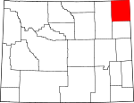
Crook County, Wyoming Basics:


Crook County Wyoming - Government Site

Population: 7,166
Area: 2854 square miles
County seat: Sundance
Area code(s) in use: 307
Time zone: MST
High school graduate or higher: 93.4%
Bachelor's degree or higher: 20.8%
Median household income: $51,319
Persons in poverty: 8.6%
Home ownership rate: 77.7%
Mean travel time to work: 22.2 minutes


Adjacent counties:
Butte (SD)  Campbell  Carter (MT)  Lawrence (SD)  Pennington (SD)  Powder River (MT)  Weston  

Find in Wyoming

Map of the Crook County area


Our detail map of Crook County shows the Crook County, Wyoming boundary lines and other interesting items.

Places in Crook County, Wyoming

  Airports     show all on map

Hulett Municipal Airport, Ipy Ranch Airport, Keyhole Airport, Schloredt Airport, Taylor Field Airport

  Basins     show all on map

Buffalo Basin, Eggie Basin, Oak Creek Basin, The Basin

  Bays     show all on map

Hell Hole

  Buildings     show all on map

Black Hills National Forest Bearlodge Ranger District Fire Engine Crew, Cook County Sheriff's Office Sundance, Crook County Fire Department, Crook County Medical Services - Sundance Emergency Medical Services, Hulett Emergency Medical Services, Hulett Fire Department, Moorcroft Police Department, Moorcroft Volunteer Fire Department, Pine Haven Volunteer Fire Department, Sundance Police Department, Sundance Volunteer Fire Department, Wyoming Highway Patrol District 1 Division Q

  Canals     show all on map

Miller Ditch

  Cemeteries     show all on map

Green Mountain Cemetery, Greenwood Cemetery, Hulett Cemetery, Inyan Kara Cemetery, Miller Creek Cemetery, Moore Hill Cemetery, Mount Moriah Cemetery, New Haven Cemetery

  Census     show all on map

Beulah Census Designated Place

  Churches     show all on map

Pine Grove Chapel, Pine Ridge Church

  Cliffs     show all on map

Lovers Leap

  Dams     show all on map

Antelope Hill Dam, Arrohead Dam, Banks Creek Dam, Barton Dam, Basin Number 1 Dam, Basin Number 2 Dam, Battle Creek Dam, Berger Dam, Betty Dam, Blacktail Dam, Bull Creek Dam, Bush Dam, Bush Ranch Dam, Bute Dam, Buzzer Dam, Cedar Creek Dam, Cedar Creek Irrigation Dam, Clark Dam, Claudie Dam, Cox Dam, Croppie Number 2 Dam, Crow Creek Dam, Deep Creek Dam, Dennis Dam, Driskill Dam, E E Wakeman Dam, Edwards Number 3 Dam, Enlargement Jesse Dam, Enlargement Little Pine Ridge Dam, Foster Dam, Fred Dam, French Dam, Gets Dam, Gose Dam, Graham Dam, H L Dam, Hagerman Dam, Havens Dam, Hawkensmith Dam, Houston Dam, Jensen Dam, Julius Hauber Dam, Kajan Diversion Dam, Keyhole Dam, Keyhole Dam, Kilpatrick Dam, King Dam, King Number 1 Dam, Kruger Creek Dam, Lake Cook Dam, Lone Tree Dam, Louis Dam, Macumba Dam, Mary and Stella Mulholland Dam, Miller Creek Dam, Moore Dam, Mowry Draw Dam, Newby Creek Dam, Newland Number 4 Dam, Oak Creek Dam, Oshoto Dam, Owl Creek Dam, Paxton Dam, Phil Dam, Raudsep Number 1 Dam, Red Arrow Dam, Richard Dam, Road Dam, Rocky Ford Dam, Sommers Dam, Spring Branch Development Company Dam, Steven Dam, Strawberry Hill Dam, Syndicate Dam, T J Maupin Number 1 Dam, T L Dam, Tract 37 Dam, Trout Dam, West Dam, Williams Dam, Yakju Dam

  Flats     show all on map

Black Flats, Ledogar Flats, Massengale Flats, Medicine Flat, Sidner Flats, Stoneville Flats, Stoneville Flats, The Bank Lake

  Hospitals     show all on map

Crook County Medical Services District Hospital, Crook County Nursing Home

  Lakes     show all on map

Bear Lake, Cook Lake, Kruger Lake, Little Keyhole Lake, Lost Lake, Medicine Lake, Missouri Buttes Lake, Montana Lake, Straight Lake, The Lake Bed

  Locales     show all on map

Ames Ranch, Ballou Ranch, Bay Ranch, Bean Ranch, Bear Lodge Campground, Bear Lodge Ranch, Bearing Tree, Belle Ranch, Bentonite Spur, Budmayer Ranch, Bunney Ranch, Bush Ranch, Campstool Ranch, Coburn Ranch, Cochrun Ranch, Crago Ranch, Cross Anchor Ranch, Dewitt Ranch, Edsall Ranch, Fort Ranch, Foster Ranch, Foster Ranch, Four Corners, G Reynolds Ranch, Geisinger Ranch, Graf Ranch, Graham Ranch, Green Hill Ranch, H Reynolds Ranch, Haley Ranch, Hall Ranch, Hall Ranch, Harney Ranch, Harney Ranch, Heetland Ranch, Hegge Ranch, Helmer Ranch, Homestake Lookout, Horse Creek Arena, Hutchinson Ranch, Hyde Ranch, Jackson Ranch, Jenkins Ranch, Jones Ranch, Kara, Keyhole Ranch, Koksh Ranch, Kunath Ranch, Lee Ranch, Leonard Ranch, Lightner Ranch, Lillian Jensen Ranch, Linch Ranch, Lincoln Ranch, Lobban Ranch, Madden Ranch, Mahoney Ranch, Maupin Ranch, Maurer Ranch, McClure Ranch, McDonald Ranch, Miller Ranch, Newland Ranch, Nielsen Ranch, Old HK Ranch, Olson Ranch, Pannell Ranch, Pearson Ranch, Pearson Ranch, PIC Ranch, Pierce Ranch, Plato Ranch, Raber Ranch, Raber Ranch, Ranch A, Ranch A National Fish Genetics Laboratory, Reuter Canyon Campground, Ridinger Junior Ranch, Ridinger Ranch, Ripley Ranch, Robinson Ranch, Robinson Ranch, Schuricht Ranch, Scoggin Ranch, Seely Ranch, Snook Ranch, Storm Ranch, Storm Ranch, Sundance District Ranger Station, Svoboda Ranch, T Cross T Ranch, Terhune, The Forks, Thompson Ranch, Thompson Ranch, Thorval Jensen Ranch, Tope Ranch, VVV Ranch, Welcome, Wenande Ranch, Whitney Ranch, Wolfe Ranch, Wonder View, Zimmerman Ranch

  Military     show all on map

Alzada Mini-Mutes Radar Site, Clark Radar Bomb Scoring Site, Colony Radar Bomb Scoring Site, Hulett Mini-Mutes Radar Site, Sundance Air Force Station (historical)

  Mines     show all on map

A A Johnson Property Mine, A A Sisson Mine, A H Claim Mine, A R Nelson Property Mine, Ackerman Mine, Albert Mann Mine, American Colloid Pits Mine, Apex Mine, Barnard Canyon Mine, Bear Creek Mountains Mine, Bear Gulch Area Mine, Bear Gulch Placer Mine, Bear Lodge District Mine, Bear Lodge Mining District Mine, Beaver Creek Mine, Belle Fourche River Number One Mine, Belle Fourche River Number Three Mine, Belle Fourche River Number Two Mine, Belsher Mine, Black Butte Deposit Mine, Black Vein Seven Mine, Bock Mine, Bolton Mine, Bull Hill Mine, Busfield Mine, C Cockran Mine, C Helmer Property Mine, Cabin Creek Four Mine, Cabin Creek Number Six Mine, Cabin Creek Seven Mine, Campstool Eleven Mine, Campstool Nine Mine, Carlile Mine, Cedar Creek Number One Mine, Cedar Creek Number Two Mine, Cedar Ridge Mine, Climax Ten Mine, Colony Mine, Copper Prince Mine, Crow Creek Mine, Davidson Property Mine, Dennis Mine, Driskell Pit, Elkhorn Creek Mine, Eureka Number Mine, Gose Ranch Property Mine, Government Valley Mine, Graves One Mine, Griffith Mine, Gumbo Creek Mine, Hauber Mine, Heetland Mine, Helmer Mine, Helmer Ranch Mine, Holmes Lease Mine, Holwell Prospects One and Two Mine, Homes Fire Lode Forty-three, Homestake Mines, Homestake Pit Number Five Mine, Homestake Pit Number Four Mine, Homestake Pit Number One Mine, Homestake Pit Number Three Mine, Homestake Pit Number Two Mine, Homestake Property Mine, Homestake Two Mine, Hutchins Consolidated Gold Mining Mine, Inum Group Mine, Inum One Claim, J.C. Vieragutz Property Mine, Jim Wayne Canyon Mine, Jones, Bury, and Murdock Property Number One Mine, Jubilee Mine, Lake Reservoir Area Number Two Mine, Laymon Lease Mine, Lewis Dennis Mine, Lytle Creek Prospect Mine, Lytle Five Claim, Lytle Three Claim, Manke Lease Mine, Middle Creek Number One Mine, Middle Creek Number Two Mine, Missouri Mine, Montana Creek Mine, Myers Mine, Nelson Mine, Nubeth Joint Venture Mine, Oak Creek Mine, Oak Creek Two Mine, Paul Myers Mine, Pearson Brother Property Mine, Peterson Deposits Mine, Pine Ridge Mine, Pine Ridge Two Mine, Poison Creek Mine, Potluck One Mine, Potluck Two Mine, Pyles and Olson Mine, Red Rock One Mine, Red Rock Two Mine, Richards and Myers Property Mine, Royal Purple Number One and Number Two Mine, Royal Purple Number One and Number Two Mine, Saddle Group Mine, Sand Creek Mine, Sand Lode Four, Shannon Lease Mine, Simmons Stockpile Mine, Sisson Mine, Sodak Mine, State Lease Number 0-22090 Mine, Stillwell Mine, Storm Mine, Summit Materials Quarry Mine, Sunny Divide Mine, Sunrise Lode Mine, Thorn Mine, Tony One Mine, Vickers Mine, Victory Lode Mine, Viergutz One Mine, Viergutz Three Mine, Viergutz Two Mine, Virginia Sixteen Mine, Warren Peaks Mine, Watson Pit Mine, White Slide Claims One-three Mine, Winco Mine

  Oilfields     show all on map

Barton Oil Field, Coyote Creek Oil Field, Donkey Creek Oil Field, Kummerfeld Oil Field, Miller Creek Oil Field, North Donkey Creek Oil Field, Selmek Oil Field, Slattery Oil Field

  Parks     show all on map

Devils Tower National Monument, Loafman Park, Washington Park

  Pillars     show all on map

Monumental City

  Populated Places     show all on map

Aladdin, Alva, Beulah, Carlile, Carlile Junction, Colony, Devils Tower, Farrall, Hay Creek (historical), Hulett, Lightning Flat (historical), Linden, Mona, Moorcroft, Moskee, New Haven, Oshoto, Pine Haven, Sand Creek Crossing, Seely, Stroner, Sundance, Vista West Trailer Park, Willow Springs

  Post Offices     show all on map

Devils Tower Post Office, Hay Creek Post Office (historical)

  Ranges     show all on map

Bear Lodge Mountains, The Brakes

  Reservoirs     show all on map

Antelope Hill Reservoir, Arrohead Reservoir, Arrowhead Reservoir, Banks Creek Reservoir, Barton Reservoir, Basin Number 1 Reservoir, Basin Number 2 Reservoir, Basin Reservoir Number 1, Basin Reservoir Number 2, Battle Creek Reservoir, Berger Reservoir, Betty Reservoir, Blacktail Reservoir, Bull Creek Reservoir, Bush Ranch Reservoir, Bush Reservoir, Bute Reservoir, Buzzer Reservoir, Cedar Creek Irrigation Reservoir, Cedar Creek Reservoir, Clark Reservoir, Claudie Reservoir, Cox Reservoir, Croppie Number 2 Reservoir, Crow Creek Reservoir, Deep Creek Reservoir, Dennis Reservoir, Driskill Reservoir, E E Wakeman Reservoir, Edwards Number 3 Reservoir, Enlargement Jesse Reservoir, Enlargement Little Pine Ridge Reservoir, Foster Reservoir, Fred Reservoir, French Reservoir, Gets Reservoir, Gose Reservoir, Graham Reservoir, Graham Reservoir, H L Reservoir, Hagerman Reservoir, Havens Reservoir, Hawkensmith Reservoir, Hemler Reservoir, Houston Reservoir, Jensen Reservoir, Julius Hauber Reservoir, Kajan Diversion Reservoir, Keyhole Reservoir, Kilpatrick Reservoir, King Number 1 Reservoir, King Reservoir, Kruger Creek Reservoir, Lake Cook, Lone Tree Reservoir, Louis Reservoir, Macumba Reservoir, Mary and Stella Mulholland Reservoir, Miller Creek Reservoir, Moore Reservoir, Mowry Draw Reservoir, Newby Creek Reservoir, Newland Number 4 Reservoir, Oak Creek Reservoir, Oshoto Reservoir, Owl Creek Reservoir, Paxton Reservoir, Phil Reservoir, Raudsep Number 1 Reservoir, Red Arrow Reservoir, Richard Reservoir, Road Reservoir, Rocky Ford Reservoir, Scott Reservoir, Shepard Reservoir, Sommers Reservoir, Spring Branch Development Company Reservoir, Steven Reservoir, Strawberry Hill Reservoir, Syndicate Reservoir, T J Maupin Number 1 Reservoir, T L Reservoir, Tract 37 Reservoir, Trout Reservoir, Wenande Reservoir Number 1, West Reservoir, Williams Reservoir, Wood Reservoir, Yakju Reservoir

  Ridges     show all on map

Blue Ridge, Brimmer Divide, Butte Divide, Cedar Ridge, Cement Ridge, Coal Divide, Coal Land Ridge, Dakota Divide, Deckelman Ridge, Elkhorn Divide, Ellsbury Divide, Goldie Divide, H K Divide, Harvey Divide, Houston Ridge, Kaiser Divide, Little Pine Ridge, Lower Pine Ridge, McFarland Divide, Nefsy Divide, Newman Divide, Norris Divide, Pine Ridge, Pine Ridge, Pine Ridge, Port Divide, Riflepit Divide, Schoepf Divide, Smith Ridge, Sunny Divide, Taylor Divide, Thorn Divide, Tower Divide, Weehinkle Divide, Williams Divide, Williams-Surprise Divide

  Schools     show all on map

Aikman School, Antelope Gulch School, Barlow Canyon School, Baroid School, Barton School, Basin School, Bitter Springs School, Brimmer School, Brislawn School, Butte School, Campstool School, Cotton School, Deer Creek School, Dirks School, Douglas School, Elkhorn School, Eothen School, Forest School, Four Oaks School, Goldie School, Government Canyon School, Government Valley School, H K School, Happy Hollow School, High School IV, Homestake School, Houston Creek School, Hulett Creek School, Hulett High School, Hulett Junior High School, Hulett School, Jay School, Johnson School, Lake Ranch School, Lame Jones School, Lower Cabin Creek School, Lytle Creek School, Miller Creek School, Moorcroft High School, Moorcroft Junior High School, Moorcroft School, Nebraska School, Oshoto School, PIC School, Rathbun School, Robinson School, Russell School, Snider School, Storm School, Sundance Elementary School, Sundance High School, Sundance Junior High School, Sundance School, Thompson Creek School, Thorn Divide School, Tower Divide School, Upper Beaver Creek School, Weaver School, Wilson School, Wood School

  Springs     show all on map

Allread Spring, Balm of Gilead Spring, Bear Den Spring, Beaverdam Spring, Big Flat Spring, Boardinghouse Spring, Boundary Spring, Box Spring, Buckley Spring, Calvert-Sacket Spring, Carlson Spring, Cliff Spring, Cole Spring, Corral Spring, Cottonwood Spring, Cranberry Spring, Davis Spring, Dean Spring, Deer Corral Spring, Deer Creek Spring, Den Spring, Dugout Spring, Dugout Spring, Elk Spring, Fawn Spring, Fish Canyon Spring, Geis Spring, Guidinger Spring, Hain Spring, Hamilton Spring, Huchins Spring, Huett Spring, Idol Spring, Jacobson Spring, Jim Wayne Spring, Jones Spring, Kaiser Spring, Katan Spring, Knapp Spring, Knoff Spring, Lehner Spring, Little Beaver Spring, Loafman Springs, Lone Grave Spring, Lost Spring, Mahoney Spring, Martin Spring, Merrick Spring, Michelson Spring, Miller Spring, Mitchell Spring, Nelson Spring, North Pine Creek Spring, Pearson Spring, Peterson Spring, Pine Creek Spring, Planting Spring, Pole Cabin Spring, Quail Spring, Rattlesnake Spring Number 1, Rattlesnake Spring Number 2, Rattlesnake Spring Number 3, Ruland Spring, Russell Spring, Sand Spring, Scott Spring, Scott-Hardy Spring, Selliez Spring, Snyder Spring, Stotts Spring, Surprise Gulch Spring, Talbot Spring, Thompson Spring, Togus Spring, Weaver Spring, Williams Number Two Spring, Williams Spring, Williams Spring, Willow Spring, Wood Spring

  Streams     show all on map

Akers Canyon Creek, Al Creek, Alkali Brook, Alkali Creek, Alum Creek, Arch Creek, Arkansas Creek, Arkansas Creek, Arnold Creek, Art Creek, Barlow Creek, Barnard Creek, Battle Creek, Bear Creek, Bear Gulch, Beaver Creek, Beaver Creek, Beaverdam Creek, Benton Creek, Berger Creek, Bitter Creek, Bitter Creek, Blacktail Creek, Boardinghouse Creek, Boggy Creek, Bond Creek, Bronco John Creek, Brushy Creek, Buck Creek, Buffalo Creek, Bull Creek, Bush Creek, Cabin Creek, Calvin Creek, Carr Creek, Carrie Nation Creek, Cedar Creek, Cedar Creek, Chassell Creek, Chicago Creek, Cleo Creek, Cold Springs Creek, Corral Creek, Corral Creek, Corral Creek, Cottonwood Creek, Cow Creek, Coyote Creek, Cracker Creek, Crazy Creek, Cub Creek, Cundy Creek, Daly Creek, Deadman Creek, Deadman Creek, Deep Creek, Deer Creek, Deer Creek, Deer Creek, Deer Creek, Deer Creek, Devils Run, Dinky Creek, Donkey Creek, Driscoll Creek, Dry Cabin Creek, Dry Creek, Dry Creek, Dry Doe Creek, Duck Creek, Dumbrill Creek, Dutch Creek, East Creek, East Creek, East Fork Blacktail Creek, Easter Creek, Edith Creek, Eggie Creek, Elkhorn Creek, Fawn Creek, Fescue Creek, Flag Butte Creek, Freda Creek, Gaff Creek, Gammon Prong, George Creek, Ghost Creek, Ghost Creek, Gimmestad Creek, Gladson Creek, Good Lad Creek, Grummit Canyon Creek, Gumbo Creek, Hay Creek, Hay Creek, Heinbaugh Creek, Hershey Creek, Hoffman Creek, Holben Creek, Horse Creek, Houston Creek, Hoyer Creek, Hulett Creek, Humboldt Creek, Inyan Kara Creek, Iron Creek, Iron Run, Joanne Creek, Kilpatrick Creek, Koch Creek, Lake Creek, Lame Jones Creek, Lawrence Creek, Left Creek, Lindsey Creek, Little Beaver Creek, Little Creek, Little Houston Creek, Little Mud Creek, Little Pine Ridge Creek, Little Piney Creek, Little Spring Creek, Lone Tree Creek, Lone Tree Creek, Lost Houston Creek, Lytle Creek, Mason Creek, Medicine Creek, Medicine Flat Creek, Middle Fork Hay Creek, Middle Fork Miller Creek, Miller Creek, Miller Creek, Mitten Prong, Montana Creek, Moore Creek, Moulton Creek, Mud Creek, Mule Creek, Mule Creek, Music Creek, North Battle Creek, North Boggy Creek, North Deer Creek, North Fork Deer Creek, North Fork Hay Creek, North Fork Little Missouri River, North Fork Miller Creek, North Fork Spring Creek, North Fork Sundance Creek, North Gammon Prong, North Miller Creek, North Redwater Creek, North Spring Creek, North Thompson Creek, Oak Canyon, Oak Creek, Oak Creek, Oak Creek, Ogden Creek, Onemile Creek, Paxton Creek, Pine Creek, Pine Draw Creek, Pine Ridge Creek, Poison Creek, Poison Creek, Porcupine Creek, Prairie Creek, Prickly Pear Creek, Red Canyon Creek, Redwater Creek, Richardson Creek, Right Creek, Right Fork Lake Creek, Ripley Creek, Road Creek, Robinson Creek, Rocky Draw Creek, Rocky Ford Creek, Rush Creek, Sabatka Creek, Sage Creek, Sage Creek, Sand Creek, Seely Fork, Shelden Creek, Short Creek, Short Prong Prairie Creek, Silver Creek, Skunk Creek, Slaybaugh Creek, Smoke Creek, Soap Creek, Soldier Creek, Sourdough Creek, South Branch Grummit Canyon Creek, South Deer Creek, South Fork Hay Creek, South Fork Little Houston Creek, South Fork Miller Creek, South Fork Ogden Creek, South Fork Owl Creek, South Fork Owl Creek, South Fork Pine Creek, South Fork Spring Creek, South Redwater Creek, Spring Branch, Spring Creek, Spring Creek, Spring Creek, Spring Creek, Spring Creek, Spring Creek, Spring Creek, Spring Creek, Sundance Creek, Thompson Creek, Thorn Creek, TL Creek, Togus Creek, Tomcat Creek, Trail Creek, Trouble Creek, Twomile Creek, Warner Springs Creek, West Fork Benton Creek, West Fork Miller Creek, West Fork Wind Creek, West Lytle Creek, Whitelaw Creek, Whitetail Creek, Willow Creek, Winchester Creek, Wind Creek

  Summits     show all on map

Bald Mountain, Bald Mountain, Bay Mountain, Bender Hill, Berger Hill, Black Buttes, Black Hills, Bock Hill, Branaman Mountain, Bull Hill, Bull Hill, Castle Rocks, Cedar Hill, Coal Mine Hill, Cockscomb Hill, Devils Tower, Devils Tower National Monument, Duling Hill, Eagle Buttes, Edsel Hills, Fish Mountain, Flag Butte, Flatiron Butte, Garland Hill, Grasshopper Butte, Green Hill, Green Hill, Green Mountain, Green Mountain, Gypsum Buttes, Hooker Peak, Inyan Kara Mountain, Iron Mountain, Iron Mountain, Lime Buttes, Little Table Mountain, Lone Tree Hill, Lytle Hill, Manly Hill, Mineral Hill, Missouri Buttes, Montgomery Hill, Monument Hill, Moore Hill, Mount Lewisa, Mud Butte, Newton Hill, Norgrain Hill, O'Haver Hill, O'Haver Peak, Oil Butte, Oudin Hill, Pfeiffer Hill, Pine Knob, Ragged Top, Rupe Hill, Sandstone Mountain, Schoolmarm Butte, Sheep Mountain, Sherrard Hill, Signal Hill, Signal Hill, Skunk Peak, Spy Glass Hill, Squaw Buttes, Stawberry Hill, Stoney Point, Storm Hill, Sugarloaf, Sugarloaf Mountain, Sundance Mountain, Table Mountain, The Notch, The Rocks, Vision Peak, Warren Peaks, Windy Point

  Towers     show all on map

Bear Lodge Mountain Lookout Tower

  Trails     show all on map

Geis Trail, Lanning Trail, Nilson Trail, Rauth Trail, Simmons Trail, Table Mountain Trail

  Valleys     show all on map

Adams Canyon, Adams Gulch, Alkali Draw, Antelope Draw, Antelope Gulch, Arrowhead Gulch, Ash Draw, Baker Canyon, Barlow Canyon, Barnard Canyon, Basin Draw, Basin Draw, Bear Den Canyon, Bear Gulch, Bear Gulch, Bear Gulch, Bear Gulch, Big Draw, Big Draw, Black Gulch, Black Haw Gulch, Boundary Gulch, Brosa Draw, Bruce Draw, Bryant Canyon, Buck Hollow, Buckley Canyon, Burnt Hollow, Busby Draw, Bush Canyon, Calvary Sacket Draw, Campstool Draw, Carson Draw, Cherry Draw, Christofferson Dam, Cole Canyon, Cottonwood Draw, Craft Draw, Cranberry Springs Gulch, Crooked S Draw, Cummins Gulch, Cyclone Canyon, Dark Canyon, Davis Canyon, Deep Draw, Dry Draw, Dry Hollow, Dugout Gulch, Duling Canyon, East Fork Boundary Gulch, East Fork Boundary Gulch, East Fork Dugout Gulch, Edward Draw, Eisbuts Draw, Fish Canyon, Foster Draw, Fredrickson Draw, Garland Draw, Government Canyon, Government Valley, Grand Canyon, Grand Canyon, Grand Canyon, Gravel Draw, Green Mountain Draw, Gumbo Draw, Hanaway Draw, Harding Gulch, Hayworth Draw, Headland Draw, Hoback Draw, Holbrook Draw, Hospital Gulch, Huett Canyon, Idol Gulch, Jacobson Draw, Jane Draw, Jim Wayne Canyon, Johnson Draw, Kirley Gulch, Krusee Canyon, Landing Strip Draw, Lincoln Gulch, Lipe Canyon, Little Draw, Long Draw, Long Draw, Lost Canyon, Lucky Gulch, Mahoney Draw, Mallory Gulch, Mallory Gulch, Manhattan Gulch, McQue Draw, Melquist Gulch, Middle Fork Boundary Gulch, Montgomery Canyon, Moore Canyon, Mosquito Draw, Myers Canyon, Nefsy Draw, Nelson Canyon, North Draw, North Draw, North Wood Canyon, Oil Draw, Page Draw, Pat Draw, Pearson Draw, Philpott Canyon, Plato Gulch, Pole Cabin Gulch, Rattlesnake Canyon, Red Canyon, Reservoir Gulch, Reuter Canyon, Reuter Draw, Riflepit Canyon, Riflepit Canyon, Robinson Draw, Rock Draw, Roena Gulch, Ronning Draw, Sage Draw, Sage Draw, Sand Draw, Sawmill Canyon, Sawmill Canyon, Sawmill Draw, Sawmill Gulch, Schelldorf Draw, Schiller Canyon, School Section Draw, Schoolhouse Gulch, Scoggin Draw, Shepherd Gulch, Sidner Draw, Smith Draw, Spottedtail Gulch, Spring Draw, Spring Draw, Spring Draw, Stanton Draw, Steam Engine Canyon, Stevens Draw, Storm Draw, Strand Draw, Surprise Gulch, Table Mountain Draw, Tent Canyon, Terry Draw, Thompson Gulch, Three Bear Gulch, Vore Draw, Wagon Canyon, Wagon Canyon, Wallace Draw, West Fork Boundary Gulch, West Fork Dugout Gulch, Wildcat Canyon, Williams Gulch, Wolfe Draw, Wood Canyon, Wood Canyon,

Crook County, Wyoming Population By Race (2012 estimate)

RacePopulation
WhiteCrook County White population 6,9376,936  
MixedCrook County Mixed population 8685
BlackCrook County Black population 7978
American IndianCrook County American Indian population 5757
AsianCrook County Asian population 1414
Hawaiian & Pacific IslanderCrook County Hawaiian & Pacific Islander population 00

Additional population tables :
State population table
Wyoming population by county