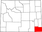
Laramie County, Wyoming Basics:


Laramie County Wyoming - Government Site

Population: 94,627
Area: 2686 square miles
County seat: Cheyenne
Area code(s) in use: 307
Time zone: MST
High school graduate or higher: 92.7%
Bachelor's degree or higher: 24.2%
Median household income: $54,596
Persons in poverty: 10.4%
Home ownership rate: 68.7%
Mean travel time to work: 15.2 minutes


Adjacent counties:
Albany  Banner (NE)  Goshen  Kimball (NE)  Larimer (CO)  Platte  Weld (CO)  

Find in Wyoming

Map of the Laramie County area


Our detail map of Laramie County shows the Laramie County, Wyoming boundary lines and other interesting items.

Places in Laramie County, Wyoming

  Airports     show all on map

Butler Airport, Cheyenne Echo Heliport, Cheyenne Regional/Jerry Olson Field Airport, Cheyenne Whiskey Heliport, Francis E Warren Air Force Base, Pine Bluffs Municipal Airport, Skyview Airpark, Sloan Airport, Thiel Field, Vowers Ranch Airport

  Buildings     show all on map

American Medical Response, Burns Emergency Medical Services, Cheyenne Fire and Rescue Station 1 Headquarters, Cheyenne Fire and Rescue Station 2, Cheyenne Fire and Rescue Station 3, Cheyenne Fire and Rescue Station 5, Cheyenne Fire and Rescue Station 6, Cheyenne Fire and Rescue Training Center, Francis E Warren Air Force Base Fire Department, Laramie County Fire District 1 Cheyenne Station 1, Laramie County Fire District 1 Cheyenne Station 2, Laramie County Fire District 10 - Granite Canyon, Laramie County Fire District 10 Harriman, Laramie County Fire District 2 Station 1 Cheyenne, Laramie County Fire District 2 Station 2 Cheyenne, Laramie County Fire District 2 Station 3 Horse Creek, Laramie County Fire District 3 Albin Fire Department, Laramie County Fire District 4 Carpenter, Laramie County Fire District 5 Pine Bluffs, Laramie County Fire District 6 Station 1 Burns, Laramie County Fire District 6 Station 2 Hillsdale, Laramie County Fire District 8 - Table Mountain, Laramie County Sheriff's Office Eastern District, Pine Bluffs Police Department, Wyoming Air National Guard Fire Department, Wyoming Highway Patrol District 1 Division A, Wyoming State Capitol

  Canals     show all on map

Adamson Ditch Number 1, Adamson Ditch Number 2, Adamson Ditch Number 3, Beaver Dam Ditch, Bolln Ditch, Carey Horse Creek Ditch Number 1, Carey Horse Creek Ditch Number 10, Carey Horse Creek Ditch Number 5, Carey Horse Creek Ditch Number 6, Carey Horse Creek Ditch Number 9, Chadwick Ditch Number 1, Chadwick Ditch Number 5, Chadwick Reservoir Number 1, Chadwick Reservoir Number 2, Chadwick Reservoir Number 3, Coad Ditch, Donahue Ditch, Dyer Ditch Number 8, Elizabeth Ditch, Garden Ditch, Gilchrist Ditch Number 4, Gilchrist Ditch Number 9, Horse Creek Ditch Number 1, Horse Creek Ditch Number 2, Horse Creek Ditch Number 3, J H D Supply Ditch, Kent Ditch, Kingman Ditch, Little Horse Creek Number 4 Ditch, Mayer Ditch, McLaughlin Ditch Number 5, McLaughlin Ditch Number 6, North Lodgepole Ditch, Petsch Ditch Number 1, Polaris Ditch, Snow Cattle Co Ditch Number 4, Sophia Ditch, South Horse Creek Ditch, Springvale Ditch, Springvale Number 1 Ditch, Springvale Number 2 Ditch, Stewart Ditch, Whitney Ditch, Wood and Lykins Ditch, Wyoming Hereford Ranch Ditch Number 1, Wyoming Hereford Ranch Ditch Number 2

  Cemeteries     show all on map

Albin Cemetery, Beth El Cemetery, Burns Cemetery, Cheyenne Memorial Gardens, Lakeview Cemetery, Lindbergh Cemetery, Little Bear Cemetery, Olivet Cemetery

  Census     show all on map

Carpenter Census Designated Place, Fox Farm-College Census Designated Place, Hillsdale Census Designated Place, Ranchettes Census Designated Place, South Greeley Census Designated Place, Warren Air Force Base Census Designated Place

  Churches     show all on map

Calvary Church, Chapel Number 1, Christ Church, Full Gospel Church, Golden Prairie America Church, Grace Church, Morrie Avenue Church, North Cheyenne Church, Pleasantview Church, Redeemer Church, Saint Marys Church

  Cliffs     show all on map

Chalk Bluffs, Pine Bluffs

  Dams     show all on map

7XL Dam, Beaver Dam, C W Dam, Campstool Dam, Carey Number 1 Dam, Clear Creek Dam, Coad Dam, Crystal Lake Dam, Culek Dam, Donahue Dam, Experiment Station Dam, Fred Hersig Dam, Gardner Dam, Gilland Dam, Gleason Number 2 Dam, Granite Springs Dam, Hirsig Enlargement R P Allen Number 1 Dam, Hirsig Number 1 Dam, Hirsig Number 2 Dam, Hirsig Number 3 Dam, Hirsig Number 4 Dam, J H D Number 1 Dam, John W Griffen Dam, Jordon Number 1 Dam, Mackley Dam, McLaughlin Number 2 Dam, North Crow Diversion Reservoir Dam, One Mile Dam, Polaris Dam, Spotswood Number 2 Dam, Swan Dam, Thomas Number 2 Dam, Ullman Number 1 Dam, Upper Van Tassell Dam, Wyoming Hereford Number 2 Dam, Wyoming Hereford Ranch Number 1 Dam

  Gaps     show all on map

Cheyenne Pass

  Hospitals     show all on map

Cheyenne Regional Medical Center, Cheyenne Veterans Affairs Medical Center, United Medical Center East, Whispering Pines Care Home

  Lakes     show all on map

Kiwanis Lake, Lake Absarraca, Lake Minnehaha, Lake Pearson, Lake Terry, Sloan Lake, Twin Mountains Lake

  Locales     show all on map

7 Mile Corral, A X Ranch, Adolphson Ranch, Altus (historical), Archer, Athol Camp, Bar Ed Ranch, Baumans Ranch, Beaver Camp, Bedortha Windmill, Bell Corral, Bell Ranch, Belvoir Ranch, Berry Camp, Berry Ranch, Bert Gillaspie Ranch, Bliss Pumping Station, Borie, Bosler Ranch, Brown Ranch, Brownell Ranch, Cameron Ranch, Campstool, Canyon Windmill, Carpenter Mill Camp, Caster Ranch, Cattail Ranch, Century Windmill, Chambers Camp, Cheyenne Country Club, Cheyenne Plaza, Cole Ranch, Cole Shopping Center, Collins Ranch, Corriedale Ranch, Coyote Camp, Coyote Mill Camp, D Kirkbride Ranch, Davis Ranch, Davis Range Camp, Derby Ranch, Dereemer Ranch, Dick Duvall Ranch, Divide Camp, Double Lazy T Ranch, Duck Creek Camp, E-7 Ranch, Eagle Camp, East Middle East Windmill, East Porter Cow Camp, Elvy Gillaspie Ranch, F L Duvall Ranch, Farthing Ranch, Farthing Ranch, Federal, Ferguson Ranch, Fork Camp, Frontier Mall, Frontier Park, Frontier Square Shopping Center, Granite Canon, Harriman, Harry Dayton Ranch, Hashknife Camp, Heifer Pasture Windmill, High Plains Grasslands Research Station, Hillside Camp, Hirsig Ranch, Hodge Spring Corral, Homes Ranch, Horse Creek Quarries, Horse Creek Siding, Hoyt Duvall Ranch, Hunter Ranch, Indian Hills Shopping Center, Intermountain Speedway, Islay Ranch, J Francis Ranch, J H D Ranch, J R Ranch, JHD Dry Camp, Johnson Ranch, Johnson Ranch, Jordan Ranch, Kelly Ranch, King Merritt Ranch, Kinnaman Ranch, Kruger Camp, L Kirkbride Ranch, L T Ranch, Lazy Heart 9 Ranch, Lewis Ranch, Lindbergh, Little Indian Camp, Lorenz Ranch, Lower J H D Sheds, Luey Huey Camp, Lummis Ranch, Mable Ranch, Mare Pasture Windmill, McDonald Ranch, McIntyre Ranch, McLees Ranch, Meadowlark Ranch, Merritt Ranch, Middle Camp, Middle East Windmill, Midway, Moffett Ranch, Moyer Ranch, Nimmo Ranch, North Mare Pasture Windmill, North Mill Camp, O'Conner Ranch, Old Francis Ranch, P O Ranch, Pasture Mill Camp, Peogh Camp, Petsch Ranch, Pole Creek Farm, Pole Creek Ranch, Prong Horn Camp, Prosser Corral, Rabbit Camp, Rees Ranch, Remount Ranch, Rhoder Windmill, Richards Hall, Robinson Place (historical), Romsa Ranch, Russel Camp, Russell Dayton Ranch, School Section Camp, Scoon Ranch, Shell Back Ranch, Shellback, Silver Crown, Site of Camp Walbach, Snow Ranch, South Triangle Windmill, Speer Windmill, State Line Camp, Swan Camp, Terry Peak Camp, Terry Ranch, The South Windmill, Tinker Windmill, Tomato Camp, Trail Creek Camp, Triangle Camp, Triangle Windmill, Upper J H D Camp, Valley Camp, Welty Ranch, West Porter Cow Camp, West Triangle Windmill, Whitaker Ranch, Whitaker Ranch, Whiting Ranch, Wilkinson Place, Willow Creek Camp, Winter Pasture Windmill, Wyo Plaza, Wyoming Angus Ranch, Wyoming Hereford Ranch, Y-Cross Ranch, Yellowstone Corral (historical)

  Military     show all on map

F E Warren Air Force Base

  Mines     show all on map

Arizona Mine, Arizona Mine, Barlett Copper King Mine, Bear Deposit, Beaver Claim, Comstock Mines, Copper King Mine, Dean Fogg Pit, Fairview Mine, Globe Prospect, Golden Goose Number Two Mine, Good Hope Mine, Granite Canyon Quarry, Great Standard Group Mine, Hecla Mine and Prospects, Hereford Pit, Horse Creek Quarry, Kopper Krown Group Mine, Kunau Pit, London Mine, Louise Mine, Lyle Faith Quarry, McCard Pit Number One, Monte Cristo Mine, Rambler Mine, Rocky Mountain Sand and Gravel Pit, Teton Gravel Pit

  Oilfields     show all on map

Borie Oil Field, Horse Creek Oil Field

  Parks     show all on map

Brimmer Park, Cahill Park, Civitan Park, Clear Creek Park, Holliday Park, Jaycee Park, Legion Park (historical), Lions Park, Martin Luther King Park, Mylar Park, Okie Blanchard Stadium, Pioneer Park, Smalley Park, United Nations Park

  Populated Places     show all on map

Albin, Altvan, Arcola, Athol, Burns, Carpenter, Cheyenne, Durham, Egbert, Farthing, Gleason, Granite, Hecla, Hillsdale, Horse Creek, Islay, Lambert, Meriden, Murke, Orchard Valley, Otto, Pine Bluffs, Ranchettes, South Greeley, Speer, Tracy, Tremain

  Post Offices     show all on map

Meriden Post Office

  Ranges     show all on map

Twin Mountains

  Reservoirs     show all on map

7XL Reservoir, Bastian Reservoir Number 1, Beaver Dam Reservoir, C W Reservoir, Campstool Reservoir, Carey Reservoir Number 1, Clear Creek Reservoir, Coad Reservoir, Crystal Lake Reservoir, Culek Reservoir, Donahue Reservoir, Equalizing Reservoir, Farthing Reservoir, Fred Hersig Reservoir, Gardner Reservoir, Gilchrist Reservoir, Gilland Reservoir, Gillard Reservoir, Gleason Number 2 Reservoir, Granite Springs Reservoir, Hirsig Enlargement R P Allen Number 1 Reservoir, Hirsig Number 1 Reservoir, Hirsig Number 2 Reservoir, Hirsig Number 3 Reservoir, Hirsig Number 4 Reservoir, J H D Reservoir Number 1, John W Griffen Reservoir, Jordon Number 1 Reservoir, King Reservoir, Mackley Reservoir, McLaughlin Reservoir Number 2, Nimmo Reservoir Number 9, North Crow Diversion Reservoir, Number 1 Reservoir, Number 5 Reservoir, Number 6 Reservoir, One Mile Reservoir, Peach Lake, Petsch Reservoir, Polaris Reservoir, Polaris Reservoir, Pole Creek Reservoir, Renslaer Reservoir, Round Top Lake, Schuyler Reservoir, South Crow Creek Reservoir, Spotswood Reservoir Number 2, Swan Reservoir, Terry Reservoir, Thomas Number 2 Reservoir, Thomas Reservoir Number 1, Thomas Reservoir Number 2, Ullman Number 1 Reservoir, Upper Van Tassell Reservoir, Valley Reservoir, Wisroth Reservoir, Wyo Hereford Ranch Reservoir Number 1, Wyoming Hereford Ranch Reservoir Number 1, Wyoming Hereford Ranch Reservoir Number 2, Wyoming Hereford Reservoir Number 2

  Ridges     show all on map

Base Line Ridge, Bristol Ridge

  Schools     show all on map

Albin High School, Albin Junior High School, Albin School, Alta Vista Elementary School, Anderson Elementary School, Arp Elementary School, Baggs Elementary School, Bain Elementary School, Buffalo Ridge Elementary School, Burns High School, Burns Junior High School, Carey Junior High School, Carpenter School, Central High School, Chalk Hill School, Chaplin School (historical), Churchill Elementary School, Cole Elementary School, Corlett Elementary School, Davis Elementary School, Deming Elementary School, Dildine Elementary School, East High School, Fairview Elementary School, Gilchrist School, Goggins School, Goins Elementary School, Hebard Elementary School, Henderson Elementary School, High School III, Hobbs Elementary School, Ingleside School, J H D School, Jessup Elementary School, Johnson Junior High School, Laramie County Community College, Lebhart Elementary School, McCormick Junior High School, McDonald School, Miller Elementary School, North Crow School, Pine Bluffs High School, Pine Bluffs Junior High School, Pine Bluffs School, Pioneer Park Elementary School, Ridley School, Robert G Afflerbach Elementary School, Rossman Elementary School, Saint Marys School, Trinity Lutheran School, University of Wyoming Experimental Station, West School, Willadsen School, Willadsen School

  Springs     show all on map

Bull Spring, Donahue Spring, Granite Springs, Mud Spring

  Streams     show all on map

Bean Creek, Brush Creek, Brush Creek, Bull Spring Creek, Bushnell Creek, Carey Creek, Cattail Creek, Cattail Creek, Clear Creek, Corlett Creek, Cottonwood Creek, Cow Creek, Diamond Creek, Dry Creek, Dry Creek, Dry Creek, Duck Creek, East Kellehan Creek, Goose Creek, Hazard Creek, Herrick Creek, Kellehan Creek, Little Horse Creek, Little Simpson Creek, Lost Corner Creek, Middle Chugwater Creek, Middle Creek, Middle Crow Creek, Middle Lodgepole Creek, Mill Creek, Miller Creek, Mills Creek, Muddy Creek, North Bear Creek, North Branch Little Bear Creek, North Creek, North Fork Crow Creek, North Fork Horse Creek, North Fork Muddy Creek, North Fork South Fork Bear Creek, North Lodgepole Creek, Paulson Branch, Ricker Creek, Sand Creek, South Chugwater Creek, South Crow Creek, South Fork Bear Creek, South Fork Horse Creek, South Fork Little Bear Creek, South Fork Middle Crow Creek, South Fork South Crow Creek, South Lodgepole Creek, Sprager Creek, Spring Branch, Spring Creek, Spring Creek, Spring Creek, Spring Creek, Spring Creek, Spring Creek, Stinking Water Creek, Threemile Creek, Trail Creek, West Kellehan Creek, Willow Creek

  Summits     show all on map

Augur Hill, Chalk Hill, Chimney Rock, Dodge Hill, Eagle Hill, Flattop, Gilbert Hill, Gurney Peak, Horse Creek Hogback, Indian Hill, Mesa Mountain, Ninemile Hill, Nob Hill, Pine Top, Round Top, Round Top, Saddleback Mountain, Steamboat Rock, Stevenson Hill, Table Mountain, Terry Anticline, Terry Peak, Whitcomb Hill

  Towers     show all on map

KFBC-AM (Cheyenne), KFBQ-FM (Cheyenne), KGWN-TV (Cheyenne), KKAZ-FM (Cheyenne), KKTU-TV (Cheyenne), KLEN-FM (Cheyenne), KLWY-TV (Cheyenne), KMUS-FM (Burns), KRAE-AM (Cheyenne), KSHY-AM (Cheyenne), KSHY-AM (Cheyenne), KSHY-AM (Fox Farm), KUUY-AM (Cheyenne), KUUY-AM (Orchard Valley), KVWO Radio Tower (Cheyenne)

  Trails     show all on map

Lattas Ranch Trail

  Valleys     show all on map

Antelope Draw, Baker Canyon, Bean Draw, Brunyansky Draw, Bullwhacker Draw, Chivington Draw, Fisher Canyon, Gundby Draw, Kelley Draw, Lewis Draw, Lewis Draw Number 2, Lewis Draw Number 3, Lewis Draw Number 4, Lewis Draw Number 4, Lewis Draw Number 5, Lewis Draw Number 6, Little Indian Draw, McCann Draw, McIntyre Draw, Middle Canyon, Nimmo Draw, Ninemile Canyon, Ninemile Draw (historical), Parker Gulch, Porter Draw, Road Canyon, Rocky Hollow, Shelton Draw, Sheppard Draw, Sweet Draw, Tromley Gulch, Wyoming Canyon

  Wells     show all on map

Bailey Number 1 Well, Bailey Number 5 Well, Bell Number 10 Well, Bell Number 11 Well, Bell Number 12 Well, Bell Number 14 Well, Bell Number 15 Well, Bell Number 16 Well, Bell Number 17 Well, Bell Number 24 Well, Bell Number 25 Well, Bell Number 5 Well, Bell Number 6 Well, Bell Number 8 Well, Eddy Well, Elkar Number 1 Well, Elkar Number 3 Well, Elkar Well, Finnerty Well, Happy Jack Number 1 Well, Happy Jack Number 2 Well, Happy Jack Number 3 Well, Holman Well, King Number 2 Well, King Number 4 Well, Koppes Number 1 Well, Koppes Number 2 Well, Koppes Number 3 Well, Koppes Number 4 Well, North Well, Snyder Well Number 20, Webber Well,

Laramie County, Wyoming Population By Race (2012 estimate)

RacePopulation
WhiteLaramie County White population 86,58486,583  
BlackLaramie County Black population 3,1233,122
MixedLaramie County Mixed population 2,3662,365
American IndianLaramie County American Indian population 1,2301,230
AsianLaramie County Asian population 1,1361,135
Hawaiian & Pacific IslanderLaramie County Hawaiian & Pacific Islander population 189189

Additional population tables :
State population table
Wyoming population by county