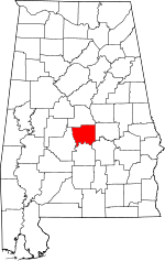
Autauga County, Alabama Basics:
Autauga County Alabama - Government Site
Population: 55,265
Area: 594 square miles
County seat: Prattville
Area code(s) in use: 334 205
Time zone: CST
High school graduate or higher: 85.1%
Bachelor's degree or higher: 21.7%
Median household income: $53,773
Persons in poverty: 11.6%
Home ownership rate: 77.7%
Mean travel time to work: 25.6 minutes
Adjacent counties:
Chilton Dallas Elmore Lowndes Montgomery
Places in Autauga County, Alabama
Prattville - Grouby Field Airport Gholson Bar,
Gordon Bar,
Graves Bar,
Holy Ground Bar,
Huffman Bar,
Manack Bar,
Newport Bar,
O'Possum Bight Bar,
Old Hell Bar,
Pauline Bar,
Swift Creek Bar,
Tallawassee Bar,
Upper Brother Bar,
Washington Bar Days Bend,
Dutch Bend Autauga County Courthouse,
Autauga County Rescue Squad,
Autauga County Sheriff's Office,
Autaugaville Volunteer Fire Department,
Billingsley Volunteer Fire Department,
Booth Volunteer Fire Department,
Independence Volunteer Fire Department,
International Paper Corporation Fire Department - Emergency Medical Services,
Jones Volunteer Fire Department,
Marbury Fire Department,
Miller State Forest Nursery,
Old Kingston Volunteer Fire Department,
Pentacost Volunteer Fire Department,
Pine Level Volunteer Fire Department,
Prattaugan Museum,
Prattville City Hall,
Prattville Fire Department Station 1,
Prattville Fire Department Station 2,
Prattville Fire Department Station 3,
Prattville Police Department,
White City Volunteer Fire Department Big Springs Cemetery,
Bildee Cemetery,
Bishop Cemetery,
Booth Cemetery,
Burt Cemetery,
Carter Cemetery,
Carter Cemetery,
Chapman Cemetery,
Coee Cemetery,
Cooper Cemetery,
County Line Cemetery,
Daniel Pratt Cemetery,
Davis Cemetery,
DeJarnett Cemetery,
Deramus Cemetery,
Doster Cemetery,
Durden Cemetery,
Durdin Cemetery,
Fair Cemetery,
Golson Cemetery,
Hamilton Cemetery,
Harmony Cemetery,
Hinton Cemetery,
Holland Cemetery,
Indian Hill Cemetery,
Jones Cemetery,
Jones Cemetery,
Jones Cemetery,
Jones Cemetery,
King Cemetery,
Lucas Cemetery,
Manning Cemetery,
Marbury Baptist Church Cemetery,
Marbury Church of God Cemetery,
Memory Gardens Cemetery,
Milton Cemetery,
Montgomery Cemetery,
New Prospect Cemetery,
Oak Hill Cemetery,
Old Harmony Cemetery,
Old Kingston Cemetery,
Owens Cemetery,
Pine Level Cemetery,
Pleasant Hill Cemetery,
Rocky Hill Cemetery,
Rodgers Cemetery,
Saint Joseph Cemetery,
Saint Paul Cemetery,
Stewart Cemetery,
Stoney Point Cemetery,
Stoudemire Cemetery,
Sunny Hill Cemetery,
Tatum Cemetery,
Thompson Cemetery,
Wilsons Cemetery Marbury Census Designated Place,
Pine Level Census Designated Place Allen Chapel,
Autauga Heights Baptist Church,
Autauga Hill African Methodist Episcopal Zion Church,
Bethel Church,
Bethesda Baptist Church,
Bethesda Church,
Bethlehem Christian Methodist Episcopal Church,
Bethlehem Lutheran Church,
Big Elam Church (historical),
Big Springs Baptist Church,
Big Springs Church,
Billingsley Church,
Boones Chapel Baptist Church,
Booth United Methodist Church,
Brown Town Church,
Calvary Baptist Church,
Camellia Baptist Church,
Canaan Land Church,
Cedar Grove Church,
Cornerstone Church,
County Line Church,
County Line Church,
County Line Church,
Crestview Baptist Church,
Davis Chapel,
Dutch Bend Church,
Elam Church (historical),
Evergreen Baptist Church,
Faith Church,
Fig Tree Baptist Church,
First Assembly of God Church,
First Baptist Church,
First Baptist Church,
First Christian Church,
First Presbyterian Church,
First United Methodist Church,
Fountain City Baptist Church,
Friendship Church,
Friendship Church,
Friendship Church,
Grace Baptist Temple,
Greater Pine Grove Church,
Greenwood Baptist Church,
Harmony Church,
Hunting Ridge Church of God,
Indian Grave Church,
Ivy Creek United Methodist Church,
Jones Church,
Kingdom Hall of Jehovahs Witnesses,
Kingston Church,
Kingston Methodist Protestant Church,
Liberty Baptist Church,
Little Zion Church,
Locust Bluff United Methodist Church,
Macedonia Baptist Church,
Maranatha Church,
Mellards Chapel Church,
Milton Baptist Church,
Mount Pisgah Church,
Mount Ramoth Church,
Mount Sinai Baptist Church,
Mount Zion United Methodist Church,
New Jerico Baptist Church,
New Mount Zion Church,
New Prospect Church,
New Salem Church,
Oak Grove Church,
Old Kingston Church,
Old Kingston Church,
Peace and Goodwill Church,
Pentecost Church,
Pilgrim Rest Baptist Church,
Pine Grove Church,
Pine Level Methodist Church,
Pink Lily Baptist Church,
Pleasant Hill African Methodist Episcopal Church,
Pleasant Hill Baptist Church,
Pleasant Hill Church,
Pleasant Valley Church,
Pleasant Valley Church,
Poplar Grove Church (historical),
Poplar Springs Church,
Popular Spring African Methodist Episcopal Zion Church,
Pratt Court Baptist Church,
Prattmont Baptist Church,
Prattville Alliance Church,
Prattville Church,
Prattville Church of Christ,
Prattville Church of God,
Prattville Community Church,
Prattville Mission Church (historical),
Prattville Missionary Baptist Church,
Rutledge Church,
Saint Josephs Catholic Church,
Saint Marks Episcopal Church,
Saint Matthew Church,
Saint Paul African Methodist Episcopal Church,
Salem Church (historical),
Shiloh Church,
Spring Hill African Methodist Episcopal Zion Church,
Spring Hill Church,
Sunny Hill Church,
Unity Church,
Vine Hill Church,
Wadsworth Baptist Church,
Ward African Methodist Episcopal Chapel,
Wesleyan Church of Prattville,
White Pond Baptist Church,
Whitewater Church,
Zions Rest Church House Bluff,
Jones Bluff Interchange 186,
Newport Ferry (historical),
Washington Ferry (historical) Bridge Creek Fishing Club Dam,
Camp Tukabatchee Lake Dam,
Circle A Ranch Dam,
Crystal Lake Dam,
Idlewood Lake Dam,
Jim Adams Lake Dam,
M A Richard Dam,
O'Dell Lake Dam,
Pickering Lake Dam,
Prattville Lake Dam,
R M Pendergrass Dam,
Robert F Henry Lock and Dam,
Underwood Lake Dam,
Upchurch Lake Dam Prattville Baptist Hospital Manacks Island (historical) Gum Cypress Lake (historical),
Jacobs Swamp,
Walkers Lake Alpha Springs,
Auburn University Prattville Experimental Field,
Autauga Landing,
Benton Landing,
Camp Alabama,
Camp Montauga,
Congregational Holiness Campground,
Crestview Shopping Center,
Dawson Mill,
Gates Mill (historical),
Gunters Farm,
Holdridges Mill (historical),
Moores Mill (historical),
Ousley Store (historical),
Perrys Landing (historical),
Prattville Country Club,
Prattville East Shopping Center,
Prattville Landfill,
Prattville Plaza Shopping Center,
Prattville Square Shopping Center,
Simmons Landing (historical),
Skyline Shopping Center,
Steeles Farm,
Steels Mill (historical),
Stillwells Mill (historical),
Stricklands Landing,
Tukabatchee Camp,
Vine Hill Station (historical),
Whitewater Camp,
Wood Landing Bell Park,
Cooters Pond Park,
Daniel Pratt Historic District,
Heritage Park,
McGray Park,
Newton Park,
North Highland Park,
Prattville Park,
R E Bob Woodruff Park,
Spinner Park,
Steeles Landing Park,
Swift Creek Park Andrew (historical),
Autauga (historical),
Autaugaville,
Beth Grove (historical),
Bethel Grove,
Billingsley,
Bonita,
Booth,
Brothers Mobile Home Park,
Browntown,
Country Club Estates,
Dosterville,
Evergreen,
Forester,
Fremont,
Gibbons (historical),
Haynes,
Hillside (historical),
Hunting Ridge,
Independence,
Joffre,
Jones,
Kalmia (historical),
King Arthur Manor,
Langford Mobile Home Park,
Live Oaks,
Marbury,
Melmar,
Milton,
Mount Sinai,
Mulberry,
New Prospect,
Oak Grove,
Old Kingston,
Old Vernon (historical),
Onoqua (historical),
Overlook,
Pate,
Peace,
Pine Flat,
Pine Level,
Poseys Crossroads,
Prattmont,
Prattville,
Pyron,
Rollins,
Smithboro (historical),
Spur (historical),
Statesville,
Stoney Point,
Upper Kingston,
Vida,
Vida Junction,
Vine Hill,
W C Rices Trailer Park,
Wadsworth,
Wadsworth,
Washington (historical),
Washington Hill,
Whispering Pines,
White City,
White Water,
Wilder Hill (historical),
Willowbrook,
Winslow,
Woodland Heights Andrew Post Office (historical),
Autaugaville Post Office, Baldwin Post Office (historical),
Billingsley Post Office, Bonita Post Office (historical), Booth Post Office (historical), Fremont Post Office (historical), Gibbons Post Office (historical), Goodson Post Office (historical), Gretna Post Office (historical),
Hamilton Post Office (historical), Haynes Post Office (historical), Hillside Post Office (historical), Hoar Post Office (historical), Hogan Post Office (historical), Huckabee Post Office (historical), Independence Post Office (historical),
Indian Springs Post Office (historical),
Jones Post Office, Kalmia Post Office (historical), Kingston Post Office (historical), Madera Post Office (historical),
Marbury Post Office, Millgin Post Office (historical), Mountama Post Office (historical), Mulberry Post Office (historical), Netezen Post Office (historical), Peace Post Office (historical), Posey Post Office (historical),
Prattville Post Office, Rayshill Post Office (historical), Rollins Post Office (historical), Samples Post Office (historical), Spur Post Office (historical), Statesville Post Office (historical), Tyus Post Office (historical), Vida Post Office (historical), Vine Hill Post Office (historical), Wadsworth Post Office (historical), White Water Post Office (historical)
Fall Line Hills Bridge Creek Lake,
Camp Tukabatchee Lake,
Circle A Ranch Lake,
Crystal Lake,
Grahamhaven Lake,
Idlewild Lake,
Jim Adams Lake,
Lake Pearl,
Pickering Lake,
Prattville Industrial Board Waste Pond,
Richard Lake,
Underwood Lake,
Wadsworth Ponds,
Whirleys Pond,
White Water Lake Autauga Academy,
Autauga County High School,
Autauga Hill School,
Autauga Vocational School,
Autaugaville Elementary School,
Autaugaville High School,
Billingsley High School,
Cavirs School (historical),
Friendship School,
Gladden School (historical),
Grace Baptist School,
Locust Bluff School,
Marbury School,
New Salem School,
Pentecost School,
Pine Flat School,
Prattville Elementary School,
Prattville High School,
Prattville Intermediate School,
Prattville Primary School,
Smith School,
Walker School (historical),
White School (historical) White Spring Autauga Creek,
Bear Creek,
Beaver Creek,
Beaver Creek,
Billdee Creek,
Boggy Branch,
Breakfast Creek,
Bridge Creek,
Buck Creek,
Coon Creek,
Dry Branch,
Dunn Branch,
Fox Creek,
Haney Branch,
Howard Creek,
Hudson Creek,
Ivy Creek,
Little Bridge Run,
Little Mulberry Creek,
Long Branch,
Mill Creek,
Mill Creek,
Molly Branch,
Motley Branch,
Noland Creek,
Parker Branch,
Pierce Creek,
Pine Creek,
Pine Creek,
Pine Level Branch,
Rogers Branch,
Sand Branch,
Sand Branch,
South Mortar Creek,
Stover Branch,
Swift Creek,
Turnback Creek,
Turnpike Branch,
Wheatley Branch,
White Water Creek,
Yellow Water Creek Gin Shop Hill,
Parker Mountain Bear Creek Swamp,
Bear Swamp,
Merritt Swamp,
Robinson Pond,
Savanna Swamp Evergreen Lookout Tower,
WIQR-AM (Prattville),
WQIM-FM (Prattville),

