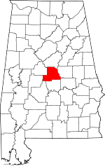
Chilton County, Alabama Basics:


Chilton County Alabama - Government Site

Population: 43,800
Area: 693 square miles
County seat: Clanton
Area code(s) in use: 205 334
Time zone: CST
High school graduate or higher: 75.7%
Bachelor's degree or higher: 12.5%
Median household income: $40,834
Persons in poverty: 18.6%
Home ownership rate: 75.1%
Mean travel time to work: 32.9 minutes


Adjacent counties:
Autauga  Bibb  Coosa  Dallas  Elmore  Perry  Shelby  

Find in Alabama

Map of the Chilton County area


Our detail map of Chilton County shows the Chilton County, Alabama boundary lines and other interesting items.

Places in Chilton County, Alabama

  Airports     show all on map

Chilton County Airport, Mayfield (Private) Airport

  Bars     show all on map

Butting Ram Shoals

  Basins     show all on map

Sawyer Cove

  Buildings     show all on map

Chilton County Courthouse, Chilton County Sheriff's Office, Clanton City Hall, Clanton Fire and Rescue Department Station 1, Clanton Fire and Rescue Department Station 2, Clanton Police Department, Collins Chapel Fire and Rescue, East Chilton Volunteer Fire and Rescue, Enterprise Volunteer Fire and Rescue Station 1, Enterprise Volunteer Fire and Rescue Station 2, Fairview Fire and Rescue 8, Gap of The Mountain Fire and Rescue Station, Isabella Volunteer Fire Department, Jemison Fire Department, Jemison Police Department, Maplesville Volunteer Fire and Rescue, North Chilton Fire and Rescue, South Chilton Fire and Rescue, Thorsby Fire Department, Thorsby Police Department, Union Grove Volunteer Fire Department, Verbena Volunteer Fire and Rescue 16, West Chilton Fire Department

  Cemeteries     show all on map

Abney Cemetery, Aldridge Family Cemetery, Alpine Cemetery, Antioch Cemetery, Antioch Cemetery, Archers Chapel Cemetery, Bell Lane Cemetery, Bethany Cemetery, Bethel Cemetery, Bethsalem Cemetery, Beulah Cemetery, Billingsley Cemetery, Campbell Cemetery, Canaan Cemetery, Cane Creek Cemetery, Cedar Grove Cemetery, Center Hill Cemetery, Chestnut Creek Cemetery, Chilton County Memorial Gardens, Clanton Cemetery, Cobb Cemetery, Collins Chapel Cemetery, Concord Cemetery, Cooper Cemetery, Corinth Cemetery, Crossroad Cemetery, Crumpton Cemetery, Davis Cemetery, Donavan Cemetery, Eastview Cemetery, Evergreen Cemetery, Floyd Cemetery, Foshee Cemetery, Foshee Cemetery, Friendship Cemetery, Glad Tidings Cemetery, Hardiman Cemetery, Harris Cemetery, Highland Cemetery, Hillcrest Cemetery, Holly Grove Cemetery, Hopewell Cemetery, Isabella Cemetery, Jacksons Chapel Cemetery, Jo Anna Cemetery, Jones Cemetery, Liberty Hill Cemetery, Lime Springs Cemetery, Lomax Cemetery, Lovelady Cemetery, Macedonia Cemetery, Macedonia Cemetery, Macedonia Cemetery, Maple Springs Cemetery, Maplesville Cemetery, Martin Memorial Cemetery, McKee Cemetery, Memorial Cemetery, Midway Cemetery, Mineral Springs Cemetery, Morning Star Cemetery, Morning Star Cemetery, Mount Bethel Cemetery, Mount Carmel Cemetery, Mount Carmel Cemetery, Mount Nebo Cemetery, Mount Pisgah-Zion Ridge Cemetery, Mount Pleasant Cemetery, Mount Zion Cemetery, Mount Zion Cemetery, Mountain Creek Cemetery, Mountain Springs Cemetery, Mulberry Cemetery, New Bethel Cemetery, New Cedron Cemetery, New Convert Cemetery, New Harmony Cemetery, New Harmony Cemetery, New Hope Cemetery, New Hope Cemetery, New Lily Hill Cemetery, New Mars Hill Cemetery, New Salem Cemetery, Oak Grove Cemetery, Oak Grove Cemetery, Oak Grove Church of God Cemetery, Oak Hill Cemetery, Old Bethel Cemetery, Old Liberty Hill Cemetery, Old Maplesville Cemetery, Old Mars Cemetery, Old Mount Nebo Cemetery, Old Raspberry Cemetery, Old Rock Springs Cemetery, Old Salem Cemetery, Pates Chapel Cemetery, Peach Cemetery, Pine Hill Cemetery, Pine Hill Cemetery, Pinedale Cemetery, Pleasant Grove Cemetery, Pleasant Grove Cemetery, Pleasant Grove Cemetery, Pleasant Hill Cemetery, Pleasant Hill Cemetery, Pleasant Hill Cemetery, Pleasant Hill Cemetery, Pleasant Hill Cemetery, Pleasant Valley Cemetery, Poplar Springs Cemetery, Popwell Cemetery, Posey Cemetery, Providence Cemetery, Providence Cemetery, Reeds Cemetery, Refuge Cemetery, Robinson Springs Cemetery, Rock Springs Cemetery, Rocky Mount Cemetery, Rocky Mount Cemetery, Saint Pauls Cemetery, Samaria Cemetery, Sardis Cemetery, Shady Grove Cemetery, Shiloh Baptist Church Cemetery, Shiloh Cemetery, Shiloh Cemetery, Shiloh-Busby Cemetery, Spring Hill Cemetery, Stanton Cemetery, Sunshine Cemetery, Temple Cemetery, Thorsby Memorial Cemetery, Thorsby Scandinavian Cemetery, Union Grove Cemetery, Union Springs Cemetery, University Highway Cemetery, Valley Creek Cemetery, Verbena Cemetery, Vermont Cemetery, Walnut Creek Cemetery, Williams Cemetery

  Churches     show all on map

Alpine Church, Antioch Church, Antioch Methodist Church, Archies Chapel, Bell Lane Baptist Church, Bethany Church, Bethel Primitive Baptist Church, Bethlehem West Church, Bethsalem Baptist Church, Beulah Church, Big Spring Church, Calvary Church, Cane Creek Baptist Church, Cedar Grove Methodist Church, Cedar Springs Church, Center Hill Church, Chestnut Creek Baptist Church, Chestnut Hill Church (historical), Church of God, Clanton Presbyterian Church, Clarks Chapel, Clearview Mission Church, Collins Chapel Baptist Church, Concord Baptist Church, Concord Church, Corinth Baptist Church, Corinth Church (historical), Cross Roads Church (historical), Crossroad Church, Dry Creek Church, Eastview Church, Ebenezer Church, Fairview Church (historical), First Baptist Church, First Born Church, First United Methodist Church, Flint Hill Church, Floyd Baptist Church, Friendship Baptist Church, Glad Tidings Church of Christ, Grove Hill Church, Happy Church, Highland Baptist Church, Highland Church of God, Hillcrest Baptist Church, Holly Grove Baptist Church, Hopewell Baptist Church, Isabella Baptist Church, Jacksons Chapel Baptist Church, Jemison Church, Jo Anna Church, Liberty Hill Baptist Church, Lime Springs Methodist Church, Lomax Church, Lomax Church of Christ, Lowerys Chapel, Macedonia Baptist Church, Macedonia Church, Maple Springs Baptist Church, Maplesville Baptist Church, Maplesville Community Church, Mars Hill Church, Maynard Chapel (historical), Midway Church of Christ, Mineral Springs Baptist Church, Morning Star Church, Morning Star Church, Mount Bethel Baptist Church, Mount Carmel Baptist Church, Mount Carmel Baptist Church, Mount Nebo Church, Mount Pisgah Church (historical), Mount Pisgah Methodist Church, Mount Pleasant Baptist Church, Mount Pleasant Church (historical), Mount Zion Church, Mount Zion Church, Mount Zion Church, Mountain Creek Baptist Church, Mountain Springs Methodist Church, Mulberry Baptist Church, Myrick Chapel, New Bethel Church, New Cedron Baptist Church, New Convert Church, New Harmony Holiness Church, New Harmony Primitive Baptist Church, New Home Church, New Hope Assembly of God Church, New Hope Church, New Lily Hill Church, New Mount Zion Church, New Salem Baptist Church, New Style Church, Oak Grove Church, Oak Hill Church, Old Cedron Church (historical), Pates Chapel Baptist Church, Pilgrim Rest Baptist Church, Pinedale Assembly of God Church, Pleasant Grove Baptist Church, Pleasant Grove Methodist Church, Pleasant Grove Missionary Baptist Church, Pleasant Hill Baptist Church, Pleasant Hill Church, Pleasant Valley Baptist Church, Pletcher Church, Poplar Springs Baptist Church, Providence Baptist Church, Providence Baptist Church, Refuge Baptist Church, Resurrection Catholic Church, Robinson Springs Baptist Church, Rock Springs Baptist Church, Rocky Mount Methodist Church, Saint James Church, Saint Pauls Baptist Church, Samaria Baptist Church, Sardis Church, Shady Grove Methodist Church, Shiloh Baptist Church, Shiloh Church, Shiloh Methodist Church, Spring Hill Church, Stanton Church, Sunshine Assembly of God Church, Temple Assembly of God Church, Thompson Chapel, Tongue Church (historical), Union Church, Union Grove Church, Union Spring Church, Unity Church, University Highway Church, Verbena Baptist Church, Verbena Church, Vermont Holiness Church, Victory Chapel, Walnut Creek Methodist Church, West End Baptist Church, Zion Ridge Church

  Crossings     show all on map

Curry Ford, Houses Ferry (historical), Interchange 200, Interchange 205, Interchange 208, Interchange 212, Interchange 219, Knights Ferry (historical), Watson Ford

  Dams     show all on map

Brantley Lake Dam, Calfee Lake Dam, Demargo Lake Dam, Gilbert Lake Dam, Gulf States Columbiana SW Dam, J H Oliver Lake Dam, J T Stewart Lake Dam, Jim Oliver Pond Dam, Lake Fountain Head Dam, Lake John Paul Dam, Lightfoot Dam, Livingston Lake Dam, Lock Twelve (historical), Luby Gore Dam, Mitchell Dam, Moores Lake Dam, Shechi Lake Dam, Shelton Barkley Lake Dam, Woodward Lake Dam

  Hospitals     show all on map

Central Alabama Hospital (historical), Chilton Medical Center

  Islands     show all on map

Big Island (historical), Big Rock, The Negrohead (historical)

  Locales     show all on map

Burwell (historical), Camp Dawson, Camp Maplesville, Chilton (historical), Chilton Area Horticulture Sub-Station, Clanton Drive-In (historical), Clanton Golf and Country Club, Clanton Pumping Station, Double Bridges, Enid (historical), Grantville (historical), Honey Cutts Mill (historical), Hunts Mill (historical), Leighs Camp, Lily (historical), Mims Crossroads (historical), Mount Bethel Youth Camp, Old Maplesville (historical), Pakan Talahassi (historical), Patella Gin (historical), Peach Queen Camp, Sears Camp, Welch Mill (historical), Zamora

  Mines     show all on map

Fitzpatrick Mine, Goldwaithe and Walkers Goldmine (historical), Judge Terrys Goldmine (historical), Maddox Mine, Old Maddox Mine

  Parks     show all on map

Alabama Music Park, Confederate Memorial Park, Panther Stadium, Susan Bentley Field, Tiger Stadium

  Populated Places     show all on map

Adams, Bessie, Campbell, Center Hill, Clanton, Collins Chapel, Cooper, Dixie, Enterprise, Fairview, Falakto, Gap of the Mountain, Highland, Hubbard, Isabella, Jemison, Jumbo, Kalona, Kincheon, Lomax, Maplesville, Mars Hill, Midway, Mineral Springs, Minooka, Mountain Creek, Mulberry, New Convert, Oak Grove, Ocampo, Parnell, Pleasant Grove, Pletcher, Pools Crossroads, Poseys Crossroads, Riderville, Rocky Mount, Samaria, Stanton, Thorsby, Union Grove, Verbena, Wessington

  Post Offices     show all on map

Ashley Post Office (historical), Chestnut Post Office (historical), Clanton Post Office, Days Mills Post Office (historical), Maplesville Post Office, Mullins Mill Post Office (historical)

  Reservoirs     show all on map

Bentleys Lake, Brantley Lake, Calfee Lake, Demargo Lake, Fountainhead Lake, Gilberts Lake, Gulf States Columbiana SW Lake, J H Oliver Lake, Jim Oliver Pond, Lake John Paul, Lightfoot Lake, Livingston Lake, Luby Gore Lake, Mitchell Lake, Moores Lake, Nix Lake, Shechi Lake Number One, Shechi Lakes, Shelton Barkley Lake, T J Stewart Lake, Woodward Lake

  Ridges     show all on map

Chandler Mountain

  Schools     show all on map

Adair School, Brewer School (historical), Cedar Grove School (historical), Chestnut Grove School, Chilton County High School, Chilton County Industrial School (historical), Chilton County Vocational Skills Center, Chilton County Vocational Technical School, Clanton Elementary School, Collins Chapel School (historical), Cooper School, Enterprise Junior High School (historical), Gulp School (historical), Isabella High School, Jemison High School, Macedonia School (historical), Maplesville High School, Mineral Springs School (historical), Pine Dale School (historical), Rocky Mountain School (historical), Smiths School (historical), Stanton Christian School, Thomas Junior High School, Thorsby High School, Thorsby Institute (historical), Verbena High School, Verbena Junior High School, Vermont School

  Streams     show all on map

Abbott Branch, Aiken Creek, Beam Branch, Bear Branch, Bear Creek, Beaver Branch, Bee Branch, Benson Creek, Bird Creek, Black Snake Creek, Blue Branch, Blue Creek, Blue Gut Creek, Boggles Creek, Broadhead Creek, Brown Branch, Buxahatchee Creek, Byrd Creek, Cane Creek, Cane Creek, Caney Branch, Caney Branch, Cargle Creek, Cedar Creek, Cedar Grove Branch, Charlotte Creek, Chestnut Creek, Clear Creek, Clear Creek, Cobb Creek, Cobb Creek, Coppers Branch, Cove Branch, Cowmire Branch, Cowwild Branch, Crawford Branch, Cressie Branch, Dry Creek, Dry Creek, Dutton Branch, Eiland Branch, Elam Creek, Flat Branch, Flat Branch, Gale Creek, Gandy Creek, Gin Creek, Gold Mine Branch, Goose Pond Creek, Harris Branch, Harris Branch, Hog Creek, Honeycutt Creek, Honeysuckle Creek, Hurricane Branch, Indian Creek, Kincheon Creek, Lester Branch, Little Creek, Little Creek, Little Mulberry Creek, Mahan Branch, Martin Creek, McKensey Creek, Miller Branch, Mohorn Creek, Mollie Branch, Morgan Creek, Mountain Branch, Mountain Creek, Mountain Creek, Page Creek, Pate Creek, Persimmon Branch, Pierce Branch, Pig Pen Creek, Pink Branch, Poley Bridge Creek, Pollis Creek, Possum Branch, Price Branch, Ram Branch, Reaves Creek, River Branch, Rocky Creek, Rocky Creek, Sam Branch, Sandy Branch, Sandy Creek, Sawmill Branch, School Branch, Simmons Branch, South Prong Chestnut Creek, Splawn Branch, Spring Branch, Stumps Creek, Talley Branch, Tanyard Branch, Third Creek, Turkey Creek, Varden Branch, Walnut Creek, Ward Creek, Wash Creek, Watson Creek, Waxahatchee Creek, West Mountain Creek, Will Redden Branch, Yellow Leaf Creek

  Summits     show all on map

Perry Mountain, Round Rock

  Swamps     show all on map

Gum Swamp

  Towers     show all on map

Perry Mountain Fire Tower, Union Grove Lookout Tower, WEZZ-FM (Clanton), WKLF-AM (Clanton),

Chilton County, Alabama Population By Race (2012 estimate)

RacePopulation
WhiteChilton County White population 38,41338,412  
BlackChilton County Black population 4,4684,467
MixedChilton County Mixed population 482481
American IndianChilton County American Indian population 219219
AsianChilton County Asian population 175175
Hawaiian & Pacific IslanderChilton County Hawaiian & Pacific Islander population 8887

Additional population tables :
State population table
Alabama population by county