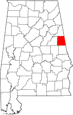
Randolph County, Alabama Basics:
Randolph County Alabama - Government Site
Population: 22,720
Area: 581 square miles
County seat: Wedowee
Area code(s) in use: 256 334
Time zone: CST
High school graduate or higher: 71.6%
Bachelor's degree or higher: 11.9%
Median household income: $35,074
Persons in poverty: 23.1%
Home ownership rate: 73.3%
Mean travel time to work: 27.9 minutes
Adjacent counties:
Carroll (GA) Chambers Clay Cleburne Heard (GA) Tallapoosa Troup (GA)
Places in Randolph County, Alabama
Roanoke Municipal Airport Butler Bridge,
Coles Bridge,
Foster Bridge,
Island Ford Bridge,
Lamar Bridge,
Lee Bridge,
Meadows Bridge,
Muckfau Bridge,
Overton Bridge,
Shelton Bridge,
Thompson Bridge,
White Bridge A and M Volunteer Fire Department,
Bethel East Volunteer Fire Department Station 14,
Corinth Volunteer Fire Department,
Dickert Volunteer Fire Department,
East Randolph County Fire Department,
Fosters Crossroads Volunteer Fire Department,
Morrison Crossroad Volunteer Fire Department,
New Hope Volunteer Fire Department,
Newell Volunteer Fire Department,
Randolph County Sheriff's Office,
Roanoke City Hall,
Roanoke Fire Department Station 1,
Roanoke Fire Department Station 2,
Roanoke Police Department Headquarters,
Roanoke Public Library,
Rock Mills Volunteer Fire Department,
Rock Stand Volunteer Fire Department,
Tin Shop Volunteer Fire Department,
Wadley Police Department,
Wadley Volunteer Fire Department,
Wedowee Police Department,
Wedowee Volunteer Fire Department,
Woodland Volunteer Fire Department Antioch Cemetery,
Antioch Cemetery,
Bear Creek Cemetery,
Bethena Church Cemetery,
Beulah Cemetery,
Big Springs Cemetery,
Booger Hill Cemetery,
Boozer Cemetery,
Brown Cemetery,
Cedarwood Cemetery,
Concord Cemetery,
Corinth Cemetery,
County Line Cemetery,
Dinglers Chapel Cemetery,
Fisher Cemetery,
Fowler Cemetery,
Friendship Cemetery,
Gay Cemetery,
Goldridge Cemetery,
Highway Cemetery,
Highway Ridge Memorial Gardens,
Knight Cemetery,
Liberty Grove Cemetery,
Malone Cemetery,
Midway Cemetery,
Mount Gilead Cemetery,
New Hope Cemetery,
Old Cool Spring Cemetery,
Old Rocky Branch Cemetery,
Old Salem Primitive Baptist Church Cemetery,
Old Shiloh Church Cemetery,
Pine Grove Cemetery,
Pine Grove Cemetery,
Pleasant Grove Cemetery,
Pleasant Hill Cemetery,
Pleasant Hill Cemetery,
Randolph Memory Gardens,
Rice Cemetery,
Shake Rag Cemetery,
Springfield Cemetery,
Swan Cemetery,
Sweetwater Cemetery,
Traylor Family Cemetery,
Union Hill Cemetery,
Valley Grove Cemetery,
Wadley Cemetery,
Wildcat Creek Cemetery,
Williams Cemetery Graham Census Designated Place,
Morrison Crossroads Census Designated Place,
Rock Mills Census Designated Place Acts Church,
Almond Church,
Antioch Church,
Auslin Chapel,
Ava Church,
Bear Creek United Methodist Church,
Bethany Lime Church,
Bethel East Church,
Bethel Methodist Episcopal Church,
Bethel West Church,
Bethlehem Camp Ground Church,
Bethlehem Church,
Beulah Church,
Big Springs Baptist Church,
Burke Chapel,
Calvary Church,
Canaan Missionary Baptist Church,
Cavers Grove Church,
Center Chapel,
Center West Church,
Chesnut Fork Church,
Christiana Church,
Concord Church,
Cool Springs Church,
Corinth Church,
Corinth Church,
Corinth Church,
County Line Baptist Church,
Dinglers Chapel Church,
El Bethel Church,
Fellowship Baptist Church,
First Baptist Church,
First Christian Church,
First United Methodist Church,
Flat Rock Church,
Flint Hill Church,
Forest Home Church,
Forester Chapel Church,
Friendship Baptist Church,
Friendship Church,
Friendship Church,
Goldridge Baptist Church,
Gray Hill Church,
Green Chapel,
Harmony Church,
Herrens Grove Church,
High Pine Baptist Church,
Highway First Congregational Methodist Church,
Hope Memorial Church,
Iduma Congregational Methodist Church,
Jordan Chapel,
Lanes Chapel,
Lebanon Church,
Levins Chapel,
Lewis Church,
Liberty Church,
Liberty East Church,
Liberty Grove Congregational Methodist Church,
Macedonia Church,
Macedonia Church,
Malone Church,
Midway Full Gospel Church,
Midway United Methodist Church,
Mission Mount Bethel Church,
Morrison Chapel,
Mount Carmel Church,
Mount Carmel Church,
Mount Gilead Baptist Church,
Mount Grove Baptist Church,
Mount Olive Church,
Mount Pisgah Baptist Church,
Mount Pleasant Baptist Church,
Mount Prospect Church,
Mount Zion Church,
Mount Zion Church,
Napoleon Church,
Neighborhood Chapel Church of God,
Neighborhood House of Prayer Church,
New Area Church,
New Harmony Church,
New Home Church,
New Hope Church,
New Life Church,
Noonday Church,
Oak Grove Church,
Oak Grove Church of Christ,
Paran Church,
Peace and Goodwill Church,
Pilgrims Rest Church,
Pine Flat Church,
Pine Hill Church,
Pine Hill Church,
Pine Hill Church,
Pineywoods Church,
Pleasant Grove Baptist Church,
Pleasant Grove Church,
Pleasant Hill Church,
Pleasant Hill Church,
Potash Church,
Prospect Congregational Methodist Church,
Providence Church,
Radney Chapel,
Riverside Church,
Roanoke Church of Christ,
Rock Mills Church,
Rock Mills First Baptist Church,
Rock Springs Church,
Rock Stand Christian Church,
Rocky Branch Baptist Church,
Rocky Mount Primitive Baptist Church,
Saint James Church,
Salem Primitive Baptist Church (historical),
Shady Creek Church,
Shiloh Church,
Shiloh Church,
Smyrna Church,
Southside Baptist Church,
Springfield Baptist Church,
Stephens Mission Church,
Taylor Crossroads Church,
The Fire Baptizes Believers Church,
Trinity Baptist Church,
Union Church,
Union Hill Church,
Union Hill Church,
Union Hill Church,
Valley Grove Church,
Victory Cathedral Church,
Victory Church,
Wehadkee Church,
Wehadkee Church,
Welcome Home Church,
Wesley Chapel Church,
Whites Chapel,
Whites Chapel,
Woodville Church,
Woodville Church,
Zion Church,
Zion Church,
Zion Rest Church,
Zion Rest Church Blake Ferry (historical),
Brown Ford (historical),
Burrow Ferry (historical),
Butlers Ferry (historical),
Foster Ford (historical),
Island Ford,
Malone Ferry (historical),
McBurnett Ford (historical),
Michels Ford (historical),
Nixon Ford,
Owen Ford,
Wellborne Ferry (historical),
Young Ford Boyd Dam,
Brady Lake Dam,
Burns Number 2 Dam,
Carpenter Dam,
Clegg and Pearson Dam,
College Lake Dam,
Concord Dam,
Frost Dam,
Gray Dam,
Higgins Dam,
High Pine Creek Watershed Dam Number 10,
High Pine Creek Watershed Dam Number 2,
High Pine Creek Watershed Dam Number 3,
High Pine Creek Watershed Dam Number 4,
High Pine Creek Watershed Dam Number 5,
High Pine Creek Watershed Dam Number 6,
Highpine Creek Watershed Dam Number 1,
Knight Dam,
Lake Louise Dam,
McCain Dam,
McManus Dam,
McMurray Dam,
Moore Dam,
Nelson Dam,
New Hope Dam,
Rice Dam,
Roanoke City Reservoir Dam,
Schuessler Dam,
Strain Dam,
Transco Dam,
Wedowee Club Lake Dam High Shoals Falls Randolph Medical Center,
Wedowee Hospital and Clinic Hodge Island,
Price Island Bell Lake,
Crystal Lake Atchinalgi (historical),
Big Hunting Club,
Byron (historical),
Camp Heard,
Crooked Creek (historical),
Gay (historical),
Level Road,
Rice Mill (historical),
Roanoke County Club,
Roanoke Sewage Disposal Plant,
Rock Stand,
Saxon Crossroads,
Stephens Mill (historical),
Tallapoosa River Hunting Club,
Taylors Mill (historical),
Tin Shop Alexandria Mine,
Arnold Prospect,
Arnott Mine,
Bagley Mine,
Campbell Mine,
Consolidated Number Five Mine,
Consolidated Number Four Mine,
Consolidated Number One Mine,
Consolidated Number Ten Mine,
Consolidated Number Three Mine,
Crews Mine,
Crystal Clear Mine,
Foote Prospect,
Foster Mine,
Friendshiip Number One Mine,
Friendship Number Two Mine,
Great Southern Number Four Mine,
Great Southern Number One Mine,
Great Southern Number Three Mine,
Great Southern Number Two Mine,
Haynes Number One Mine,
Haynes Number Two Mine,
Holmes Prospect,
Holmes Prospect,
Jack Rice Mine,
Jones Number One Mine,
Jones Prospect,
Kitchen Prospect,
Knopf Prospects,
Knott Prospect,
Liberty Mine,
McAdoo Mine,
Miller Mines,
Morrison Mine,
New Number One Mine,
New Number Two Mine,
Old Anicent Mine,
Pinetucky Mine,
Pinetucky Number One Mine,
Schefner Mine,
Silver Leaf Prospect,
Spring Hill Number One Mine,
Spring Hill Number Three Mine,
Spring Hill Number Two Mine,
Tennant Prospect,
Vickers Number Four Mine,
Vickers Number One Mine,
Wallace Number One Mine,
Wallace Number Two Mine,
Weeks Mine,
Whitehead Prospects,
York Prospect,
Zeesman Pit Almond,
Ava,
Bacon Level,
Barrett Crossroads,
Bethel,
Big Springs,
Blake,
Broughton,
Butlers Mill,
Cambridge,
Cavers Grove,
Cedron,
Center Chapel,
Center West,
Christiana,
Concord,
Corbin,
Corinth,
Corinth,
Cornhouse,
Curt,
Dickert,
Dingler,
Folsom,
Forester Chapel,
Foster Crossroad,
Friendship,
Fuller Crossroad,
Gold Ridge,
Graham,
Harmon Crossroads,
Hawk,
Haywood,
High Pine,
High Shoals,
Hobson,
Jordan Chapel,
Kaylor,
Lamar,
Lee Crossroads,
Liberty,
Liberty Grove,
Lime,
Lofty,
Louina,
Malone,
Midway,
Milner,
Moores Crossroads,
Morrison Crossroad,
Mount Olive,
Mount Pleasant,
Mount Zion,
Napoleon,
New Hope,
Newell,
Ofelia,
Omaha,
Paran,
Peace,
Peavy,
Pine Hill,
Pine Tuckey,
Pooles Crossroad,
Potash,
Providence,
Roanoke,
Rock Mills,
Rockdale,
Rocky Branch,
Sewell,
Smyrna,
Springfield,
Swagg,
Taylors Crossroads,
Tennant,
Union,
Wadley,
Waldrep,
Wedowee,
Wehadkee,
West,
White Crossroads,
White Signboard Crossroad,
Wildwood,
Woodland Almond Post Office (historical), Bear Creek Post Office (historical), Bernice Post Office (historical), Blakes Ferry Post Office (historical), Buchanan Post Office (historical), Byron Post Office (historical), Cambridge Post Office (historical), Carters Store Post Office (historical), Christiana Post Office (historical), Clack Post Office (historical), Clint Post Office (historical), Corbin Post Office (historical), Corinth Post Office (historical), Cornhouse Post Office (historical), Dickert Post Office (historical), Dingler Post Office (historical),
Eastville Post Office (historical), Fair Play Post Office (historical), Foresters Chapel Post Office (historical), Fox Creek Post Office (historical), Goldburg Post Office (historical),
Graham Post Office, Gridley Post Office (historical), Handley Post Office (historical), Hawk Post Office (historical), Haywood Post Office (historical), High Shoals Post Office (historical), Hoyt Post Office (historical), Huckeba Post Office (historical), Ice Post Office (historical),
Ingraham Post Office (historical), Jay Post Office (historical), Jeptha Post Office (historical), Kaylor Post Office (historical), Level Road Post Office (historical), Levonia Post Office (historical), Lime Post Office (historical), Lofty Post Office (historical), Louina Post Office (historical), Malone Post Office (historical), Milner Post Office (historical), Napoleon Post Office (historical),
Newell Post Office, Ocre Post Office (historical), Ofelia Post Office (historical), Omaha Post Office (historical), Paran Post Office (historical), Peace Post Office (historical), Peavy Post Office (historical), Pencil Post Office (historical), Pittman Post Office (historical), Potash Post Office (historical),
Roanoke Post Office, Sewell Post Office (historical), Slate Hill Post Office (historical), Swag Post Office (historical), Swanhill Post Office (historical), Swann Post Office (historical), Tallapoosa Post Office (historical), Tenant Post Office (historical), Thurman Post Office (historical), Tolbut Post Office (historical), Viola Post Office (historical),
Wadley Post Office, Waldrep Post Office (historical),
Wedowee Post Office, Wehadkee Post Office (historical), West Post Office (historical), White Post Office (historical), Wichie Post Office (historical), Wildwood Post Office (historical),
Woodland Post Office, Woods Ferry Post Office (historical)
Horton Shoal Bartlett Pond,
Barton Lake,
Boyd Lake,
Brady Lake,
Burns Lake Number 2,
Burns Lakes,
Carpenter Lake,
Clegg and Pearson Lake,
College Lake,
Concord Lake,
Frost Lake,
Grays Lake,
Higgins Lake,
High Pine Creek Lake Number 10,
High Pine Creek Lake Number 2,
High Pine Creek Lake Number 3,
High Pine Creek Lake Number 4,
High Pine Creek Lake Number 5,
High Pine Creek Lake Number 6,
Highpine Creek Lake Number 1,
Lake Louise,
McManus Pond,
McMurray Lake,
Moores Pond,
Nelson Lake,
New Hope Lake,
R L Harris Reservoir,
Rice Pond,
Roanoke City Lake,
Wedowee Club Lake,
Woodland Lake Big Springs School (historical),
Folsom Elementary School,
Handley High School,
Handley Middle School,
Knight Enloe Elementary School,
Midway School (historical),
Mount Carmel School,
Pleasant Grove School,
Randolph County High School,
Randolph County Training School,
Rock Mills Junior High School,
Southern Union State College,
Wadley High School,
Wedowee High School,
Woodland High School Allen Branch,
Andanley Branch,
Bear Creek,
Beaverdam Creek,
Boatner Creek,
Boone Creek,
Buck Branch,
Buck Branch,
Buckhannon Creek,
Bud Coffee Branch,
Cane Creek,
Carlisle Branch,
Cedar Creek,
Cohobadiah Creek,
Coppers Rock Creek,
Cornhouse Creek,
Crooked Creek,
Cutnose Creek,
Dewberry Branch,
Edwards Branch,
Farmer Creek,
Fixico Creek,
Fox Creek,
Frog Level Branch,
Fuller Creek,
Gaston Branch,
Ginhouse Branch,
Gladney Mill Branch,
Gobbler Creek,
Graves Creek,
Green Creek,
Griswold Creek,
Henson Branch,
Hillabeehago Branch,
Hornyhead Branch,
Horton Shoal Branch,
Hunter Branch,
Hunter Branch,
Hunter Creek,
Hurricane Creek,
Jack Branch,
Jacks Branch,
Jones Creek,
Ketchepedrakee Creek,
Kidd Branch,
Knight Branch,
Knokes Creek,
Lane Branch,
Liles Branch,
Little Ketchepedrakee Creek,
Little Pineywood Creek,
Little Tallapoosa River,
Little Wehadkee Branch,
Little Wehadkee Creek,
Lost Creek,
Mad Indian Creek,
Meacham Creek,
Miles Branch,
Mill Branch,
Mud Creek,
No Business Creek,
Panther Branch,
Pineywood Creek,
Price Branch,
Red Caty Creek,
Rice Branch,
Rocky Branch,
Rollins Creek,
Sandy Creek,
Shoal Creek,
Stitt Branch,
Tanyard Branch,
Town Creek,
Town Creek,
Triplett Creek,
Turkeypen Creek,
Turpentine Still Branch,
Vineyard Branch,
Wedowee Creek,
Wesobulga Creek,
Wildcat Creek,
Willingham Branch,
Wolf Creek,
Wolfpen Creek Buck Mountain,
Cockrell Mountain,
Flat Rock,
Oak Mountain,
Plunkett Mountain,
Swan Hill Lookout Tower,
WELR-AM (Roanoke),
WELR-FM (Roanoke),

