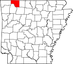
Carroll County, Arkansas Basics:


Carroll County Arkansas - Government Site

Population: 27,639
Area: 630 square miles
County seat: Berryville
Area code(s) in use: 479 870
Time zone: CST
High school graduate or higher: 81.2%
Bachelor's degree or higher: 16.5%
Median household income: $35,558
Persons in poverty: 17.7%
Home ownership rate: 71.6%
Mean travel time to work: 19.7 minutes


Adjacent counties:
Barry (MO)  Benton  Boone  Madison  Newton  Stone (MO)  Taney (MO)  
Find in Arkansas

Map of the Carroll County area


Our detail map of Carroll County shows the Carroll County, Arkansas boundary lines and other interesting items.

Places in Carroll County, Arkansas

  Airports     show all on map

Black Horse Landing Ultralight Flightpark, Buck Mountain Airport, Carroll County Airport, Carroll General Hospital Heliport, Flying Machines Airstrip Ultralight Flightpark, Silver Wings Field Airport, Smith Heliport

  Bends     show all on map

Barnett Bend, Gum Bottom, Mason Bend, Stewart Bend

  Bridges     show all on map

Beaver Bridge, Mulladay Hollow Bridge

  Buildings     show all on map

Arkansas Game and Fish Commission Law Enforcement Northwest Regional Office, Berryville Fire Department, Berryville Police Department, Carroll County Courthouse, Carroll County Sheriff's Office, Eureka Springs Fire Department, Eureka Springs Fire Department Ambulance, Eureka Springs Fire Department Station 2, Eureka Springs Fire Department Station 3, Eureka Springs Fire Department Station 4, Eureka Springs Police Department, Grassy Knob Volunteer Fire Department, Green Forest Police Department, Green Forest Volunteer Fire Department, Hammond Bell Museum, Harps Doll Museum, Holiday Island Fire Department Ambulance, Holiday Island Fire Department Station 1, Holiday Island Volunteer Fire Department Station 2, Holiday Island Volunteer Fire Department Station 3, Holiday Island Volunteer Fire Department Station 4, Inspiration Point Volunteer Fire Department Main Station, Inspiration Point Volunteer Fire Department Substation, Oak Grove Volunteer Fire Department Station 1, Oak Grove Volunteer Fire Department Station 2, Saint John's Emergency Medical Service Carroll County, South Carroll County Volunteer Fire Department Station 1, South Carroll County Volunteer Fire Department Substation

  Cemeteries     show all on map

Beaver Cemetery, Berryville Memorial Cemetery, Beulah Union Cemetery, Blackjack Cemetery, Bobo Cemetery, Boyd Cemetery, Briley Cemetery, Bunch Cemetery, Burris Cemetery, Carr Cemetery, Carrollton Cemetery, Chaney Cemetery, Dean Cemetery, Denver Cemetery, Dog Branch Cemetery, Enon Cemetery, Eureka Springs Cemetery, Fancher Cemetery, Farmer Cemetery, Fuller Cemetery, Gaskins Switch Cemetery, Gibbs Cemetery, Glenwood Cemetery, Gobbler Cemetery, Grandview Cemetery, Hale Cemetery, High Cemetery, Jones Cemetery, Marshall Cemetery, McCracken Cemetery, McGehee Cemetery, McMillion Cemetery, Moore Cemetery, Moreland Cemetery, Mountain View Cemetery, New Home Cemetery, Norris Cemetery, Oak Hill Cemetery, Oak Hills Cemetery, Parker Cemetery, Pension Mountain Cemetery, Pickens Cemetery, Pleasant Valley Cemetery, Riddle Cemetery, Rule Cemetery, Rush Cemetery, Shady Grove Cemetery, Sisco Cemetery, Sites Cemetery, Sites Cemetery, Snead Cemetery, Snow Cemetery, Walden Cemetery, Ward Cemetery, White Oak Cemetery, Williams Cemetery, Yocum Cemetery, York Cemetery, Zion Hill Cemetery

  Census     show all on map

Holiday Island Census Designated Place

  Churches     show all on map

Antioch Church of God of the Apostolic Faith, Assembly of God Church, Berkes Community Church, Berryville United Methodist Church, Beulah Church, Blackjack Church, Boyd Church, Busch Church, Christ of the Ozarks, Church of Christ, Church of Christ, Cove Church, Fanning Church, First Baptist Church, First Baptist Church, First Christian Church, First Freewill Baptist Church, First Presbyterian Church, First Presbyterian Church, Freeman Heights Baptist Church, Freewill Church, Gobbler Church, Grassy Knob Church, Hale Church, High Church, Hill Church, Moore Church, Mulberry Church, Pleasant Valley Church, Possum Trot Church, Rock Springs Baptist Church, Saint Elizabeth Catholic Church, Shady Grove Baptist Church, Shady Grove Church, Snow Church, Trinity Free Will Baptist Church, Union Chapel (historical), Union Church, Ward Church, Westside Christian Church, White Oak Church, Winona Springs Church, Zion Hill Church

  Cliffs     show all on map

Bee Bluff, Cedar Bluff, Chaney Bluff, Crane Roost Bluff, Davis Bluff, Gallion Bluff, Harris Point, Inspiration Point, Pine Bluff, Poker Bluff, Rolloff Bluff, Salts Bluff, Sims Point, Stony Point, Wallace Bluff

  Crossings     show all on map

Applegate Ford, Littrel Ford, McKennon Ford, Simmons Ford, Summers Ford

  Dams     show all on map

Beaver Dam, Brewer Lake Dam, Eureka Springs City Lake Dam, Farwell Spider Creek Lake Dam, Fuller Lake Dam, Jackson Lake Dam, Lake Leatherwood Dam, Lake Lucerene Dam, Lake of No Return Dam

  Forests     show all on map

Green Forest

  Gaps     show all on map

Allen Gap, Bradfield Gap, Charcoal Gap, Duncan Gap, Jennings Gap, Lucky Gap, Trigger Gap

  Hospitals     show all on map

Carroll Regional Medical Center, Eureka Springs Hospital, Mercy - Saint Johns Hospital Berryville

  Locales     show all on map

Elk Ranch, Hanbys Mill (historical)

  Parks     show all on map

Beaver Dam Site Park, Cricket Creek Public Use Area, Eureka Springs Historic District, Harmon Park

  Pillars     show all on map

Pivot Rock

  Populated Places     show all on map

Ashley (historical), Beaver, Berryville, Blue Eye, Brasswell Spring (historical), Busch, Cabanal, Carrollton, Cave Spring (historical), Cisco, Coin, Conner, Dean, Delmar, Denver, Dryfork, Enon (historical), Eureka Springs, Farewell, Freeman (historical), Gaskins (historical), Gobbler, Grandview, Green Forest, High, Holiday Island, Hough, Indian Creek (historical), Junction (historical), Kirtley (historical), Lone Star, Maple, Metalton, Mundell (historical), New Town (historical), Norton (historical), Nunnally (historical), Oak Hill, Oakgrove, Osage, Pleasant Ridge, Pleasant Valley, Polo (historical), Raum (historical), Rudd, Rule, Tunnel (historical), Urbanette, Walden (historical), Winona Springs (historical), Wolf Pen (historical), Yocum

  Post Offices     show all on map

Busch Post Office, Connor Post Office (historical), Delmar Post Office (historical), Denver Post Office (historical), Dry Fork Post Office (historical), Enon Post Office (historical), Grandview Post Office (historical), High Post Office (historical), Little Star Post Office (historical), Metalton Post Office (historical), Omega Post Office (historical), Rudd Post Office (historical), Springlawn Post Office (historical), Tarkiln Post Office (historical), Thompsonville Post Office (historical), Wolf Pen Post Office (historical)

  Reservoirs     show all on map

Brewer Lake, Eureka Springs City Lake, Farwell Spider Creek Lake, Fuller Lake, Jackson Lake, Lake Lucerene, Lake of No Return, Leatherwood Lake

  Ridges     show all on map

Mill Ridge, Turkey Wing Ridge

  Schools     show all on map

Armo Baptist Academy (historical), Berryville Elementary School, Berryville High School, Berryville Middle School, Braswell Springs School (historical), Carrollton School (historical), Dean School (historical), Eureka Springs Elementary School, Eureka Springs High School, Eureka Springs Middle School, Farwell School (historical), Green Forest Elementary School, Green Forest High School, Green Forest Intermediate School, Moore School (historical), Oak Grove School (historical), Oak Hill School (historical), Pension Mountain School, Rock Springs School (historical), Rudd School (historical), Rule School (historical), Urbanette School (historical), Winona School (historical)

  Springs     show all on map

Basin Spring, Big Spring, Blue Spring, Blue Spring, Braswell Spring, Bull Spring, Cave Spring, Hale Spring, Hammond Spring, Herd Spring, Johnson Spring, MacMerry Spring, Magnetic Spring, Patty Spring, Reves Spring, Tanyard Spring, Winona Springs, Wood Spring

  Streams     show all on map

Bee Creek, Bobo Creek, Braswell Branch, Brush Creek, Butler Creek, Callens Branch, Cedar Creek, Cedar Creek, Cedar Creek, Clabber Creek, Clayborn Creek, Cranenest Creek, Denny Spring Branch, Dicks Creek, Dishrown Creek, Dog Branch, Dry Creek, Flat Rock Creek, Freeman Branch, Haddock Creek, Honey Creek, Keels Creek, Kenner Branch, Kenner Creek, Leatherwood Creek, Long Creek, Marshall Branch, Mill Branch, Mills Branch, North Fork Dry Fork, North Fork North Clifty Creek, Osage Creek, Pine Creek, Piney Creek, Possum Trot Creek, Rocky Fork, Sites Branch, South Fork Dry Creek, Spider Creek, Spring Creek, Stillhouse Creek, Stony Point Branch, Tan Yard Branch, Warden Branch, Waxweed Run, West Leatherwood Creek, Wilder Branch, Yocum Creek

  Summits     show all on map

Anderson Mountain, Ant Mountain, Black Mountain, Blacklick Mountain, Boat Mountain, Bradshaw Mountain, Brother Knobs, Brush Mountain, Brushy Knobs, Brushy Mountain, Buck Mountain, Chinkapin Mountain, Coffman Mountain, Collier Mountain, Crystal Mountain, Dewees Mountain, Dodson Mountain, Flower Pot Point, Fort Mountain, Fultz Mountain, Gage Mountain, Gobbler Point, Grindstone Mountain, Holden Mountain, Huckleberry Point, Indigo Knob, Jackson Mountain, Jim Fultz Mountain, Kimhowart Hill, Lone Tree Mountain, Mack Mountain, Miles Mountain, Mill Mountain, Miller Mountain, Mount Oberammergau, Needle Eye Mountain, Panorama Point, Pension Mountain, Pilot Knob, Pilot Knob, Pine Mountain, Pinnacle, Pond Mountain, Potato Hill, Rock Quarry, Rolloff Mountain, Round Mountain, Round Mountain, Saffer Mountain, Saunders Heights, Sister Knob, Snow Knob, Stanley Mountain, Sugar Mountain, Sugarloaf Mountain, Trigger Mountain, Usrey Mountain, Waldrop Mountain, Walker Mountain, Wilkins Mountain, Woods Knob

  Towers     show all on map

KSCC-FM (Berryville), KTCN-FM (Eureka Springs), KTHS-AM (Berryville)

  Valleys     show all on map

Alford Cove, Allen Hollow, Bear Hollow, Bear Hollow, Big Mill Hollow, Blackjack Hollow, Blowing Spring Hollow, Bradley Hollow, Brawley Hollow, Brown Hollow, Brushy Hollow, Bunch Canyon, Buzzard Roost Hollow, Canfield Hollow, Carpenter Hollow, Catron Hollow, Cave Hollow, Dark Hole Hollow, Democrat Hollow, Denton Cove, Devils Pocket, Durham Mill Hollow, Dutchman Hollow, Elk Ranch Hollow, Farmer Hollow, Fortner Hollow, Garver Hollow, Hailey Hollow, Henry Hollow, Hogscald Hollow, Hollingsworth Hollow, Hoppins Hollow, Hurt Hollow, Hurth Hollow, Hyde Hollow, Jim Mill Hollow, Jody Hollow, Kittner Hollow, Lead Hollow, Livingston Hollow, Lucky Hollow, Mack Hollow, May Hollow, Mead Hollow, Miller Hollow, Miller Hollow, Mulladay Hollow, Ott Hollow, Outlaw Hollow, Owl Hollow, Paxton Hollow, Penitentiary Hollow, Pine Hollow, Pitcher Hollow, Pivot Rock Hollow, Poddy Hollow, Racetrack Hollow, Sally Hollow, Schriborough Canyon, Slickrock Hollow, Smith Hollow, Spicewood Hollow, Stillhouse Hollow, Tarpin Hollow, Tereherst Hollow, Wagon Shed Hollow, Warrick Hollow, Waterfall Hollow, White Oak Hollow, Whooping Hollow, Wilcox Hollow, Wildcat Hollow, Williams Hollow, Winding Staircase Hollow, Winona Hollow, Zink Hollow,

Carroll County, Arkansas Population By Race (2012 estimate)

RacePopulation
WhiteCarroll County White population 26,34026,339  
MixedCarroll County Mixed population 498497
American IndianCarroll County American Indian population 332331
AsianCarroll County Asian population 193193
Hawaiian & Pacific IslanderCarroll County Hawaiian & Pacific Islander population 8382

Additional population tables :
State population table
Arkansas population by county