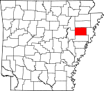
Cross County, Arkansas Basics:


Cross County Arkansas - Government Site

Population: 17,686
Area: 616 square miles
County seat: Wynne
Area code(s) in use: 870
Time zone: CST
High school graduate or higher: 80.0%
Bachelor's degree or higher: 11.9%
Median household income: $39,665
Persons in poverty: 16.2%
Home ownership rate: 67.7%
Mean travel time to work: 24.6 minutes


Adjacent counties:
Crittenden  Jackson  Poinsett  St. Francis  Woodruff  
Find in Arkansas

Map of the Cross County area


Our detail map of Cross County shows the Cross County, Arkansas boundary lines and other interesting items.

Places in Cross County, Arkansas

  Airports     show all on map

Cross County Hospital Heliport, Hess Strip Airport, Runsick Flying Service Airport, Wynne Municipal Airport

  Bars     show all on map

Austelle Bar, Fortune Bar, Lee Bar, Mussel Bar, Sugar Bar, Turnbull Bar, Wheeler Bar

  Bends     show all on map

Ash Bend, Barrow Bend, Block Bend, Grassy Lake, Johnson Bend, Morris Bend, Short Bend, Short Bend, Woods Bend

  Buildings     show all on map

Bay Village Volunteer Fire Department, Cherry Valley Police Department, Cherry Village Volunteer Fire Department, Crest Park Nursing Home, Cross County Courthouse, Cross County Library, Cross County Sheriff's Office, Fair Oaks Volunteer Fire Department, Hickory Ridge Volunteer Fire Station, Parkin Police Department, Parkin Volunteer Fire Department, Southern Care Wynne, Southern Care, Incorporated - Cherry Valley, Vanndale Volunteer Fire Department, Wynne City Hall, Wynne Fire Station, Wynne Police Department

  Canals     show all on map

Bushy Creek Ditch, Cross County Ditch, Ditch Number 1, Ditch Number 14, Ditch Number 15, Ditch Number 2, Ditch Number 210, Ditch Number 24, Ditch Number 9, First Creek Canal, Straight Slough

  Cemeteries     show all on map

Akins Cemetery, Bowers Cemetery, Cogbill Cemetery, Gatlen Cemetery, Halk Cemetery, Harefarm Cemetery, Hawk Cemetery, McDonald Cemetery, McElroy Cemetery, Mount Maria Cemetery, Pilgrim Rest Cemetery, Riley Cemetery, Saint Marks Cemetery, Slocum Cemetery, Smith Cemetery, Spring Hill Cemetery, Stark Cemetery, Union Grove Cemetery, Walnut Grove Cemetery, Walters Cemetery, Warren Cemetery, Wynne Cemetery

  Churches     show all on map

Antioch Church, Apostolic Holiness Church (historical), Bay Ferry Church, Bethel Church, Bethlehem Church, Butler Chapel, Candlelight Baptist Church, Central United Methodist Church, Christian Fellowship Church, Clarks Church, East Baptist Church, Egypt Church, Ellis Chapel United Methodist Church, Evening Time Church, Fair Oaks Baptist Church, Feltner Church, First Assembly of God Church, First Baptist Church, First Freewill Baptist Church, First United Methodist Church, Fitzgerald Baptist Church, Fondren Memorial Presbyterian Church, Fortune Church, Glad Acre Church, Gladden Church, Grace Baptist Church, Harris Chapel Baptist Church, Hit Chapel, Johnson Chapel, Johnson Church, Jones Temple, Lake View Church, Levesque Assembly of God Church, Lewis Church, Locust Grove Church, Macedonia Church, Manns Church, McDonald Church, McElroy Baptist Church, McElroy United Methodist Church, Merck Church, Mount Olive Church, Mount Omah Baptist Church, Mount Pisgah Church, Mount Tabor Baptist Church, Mount Zion Church, Myres Chapel, New Bethel Church, New Hope Baptist Church, New Hope Baptist Church, New Hope Church, New Light Church, New Saint James Church, Pilgrim Rest Church, Rolfe Church, Saint James Baptist Church, Saint Marks Church, Saint Mary Christian Methodist Episcopal Church, Saint Peters Church, Shady Grove Church, Shady Grove Church, Sharps Chapel, Smith Chapel Methodist Church, Springhill Church, Thomas Church, Tilton Church, Tilton Methodist Church, Togo Baptist Church, Togo Missionary Baptist Church (historical), Union Avenue Baptist Church, Union Valley Baptist Church, Valley View Baptist Church, Wynne Baptist Church, Wynne Church of Christ

  Crossings     show all on map

Old Neelys Ferry (historical), Twist Ferry (historical), Wittsburg Ferry (historical)

  Dams     show all on map

Caney Creek Site 3a Dam, Caney Creek Site Five Dam, Caney Creek Site Four Dam, Caney Creek Site One Dam, Caney Creek Site Seven Dam, Caney Creek Site Six Dam, Caney Creek Site Two Dam, Gardner Lake Dam, Hall Lake Dam, Hidden Valley Lake Dam, Hunter Rest Club Lake Dam, Lake Austell Dam, Lake Dunn Dam, Pufahl Lake Dam, Robinson Lake Dam

  Flats     show all on map

Locust Lake, Pemiscot Lake, Smith Lake, Sunk Timber Lake, Wittsburg Island

  Hospitals     show all on map

Crossridge Community Hospital, East Arkansas Mental Health Center

  Lakes     show all on map

Allens Lake, Anderson Lake, Barnes Lake, Dog Pond, Fishing Lake, Grassy Lake, Harris Pond, Hill Lake, Jack Lake, Little Blackfish Lake, Neelys Lake, Old River, Patterson Lake, Prophet Lake, Rainbow Lake, Shaver Lake, Snowden Lake, Swan Lake, Walnut Timber Lake, Wittsburg Lake, Yancopin Lake

  Locales     show all on map

Bott Spur, Burr Place, Crowley Ridge Country Club, McManus Spur, Wrapes Spur (historical), Yarbo Place

  Military     show all on map

Fort Russell (historical)

  Parks     show all on map

Parkin Mound Archeological State Park, Village Creek State Park

  Populated Places     show all on map

Aberdeen (historical), Belknap (historical), Birdeye, Budsmith (historical), Central, Cherry Valley, Coldwater, Colton Crossing, Dunn (historical), Duvall, Ellis Chapel, Fair Field, Fair Oaks, Fitzgerald Crossing, Flag Lake Crossing, Fortune, Gieseck, Gladden, Hamlin, Hickory Ridge, L'Anguille, Levesque, Love Place, McDonald, McElroy, Merck (historical), Mersman, Monterey, Mounds, Parkin, Pittinger, Pleasant Hill, Princedale, River Front, Riverside, Rose Place, Saint Francis (historical), Smith Chapel, Smithdale, Tilton, Togo, Turney (historical), Twist, Vanndale, Welford (historical), Wick Mill, Wilkins, Wittsburg, Wrape (historical), Wynne, Yarbo Place

  Post Offices     show all on map

Birdeye Post Office, Parkin Post Office, Twist Post Office, Wynne Post Office

  Reservoirs     show all on map

Caney Creek Site 3a Reservoir, Caney Creek Site Five Reservoir, Caney Creek Site Four Reservoir, Caney Creek Site One Reservoir, Caney Creek Site Seven Reservoir, Caney Creek Site Six Reservoir, Caney Creek Site Two Reservoir, Cathy Lake, Cooper Pond, Gardner Lake, Hall Lake, Hidden Valley Lake, Hunter Rest Club Lake, Lake Austell, Lake Dunn, Pufahl Reservoir, Robinson Lake

  Ridges     show all on map

Crowleys Ridge

  Schools     show all on map

Antioch School (historical), Burr School, Campbell School, Cherry Valley Elementary School, Cherry Valley High School (historical), Cobbs Boarding School (historical), Coldwater School (historical), Cross County High School, Hare Farm School (historical), Hickory Ridge Elementary School, Hickory Ridge High School (historical), Lansing Grove School (historical), Mersman School (historical), Morledge School (historical), New Hope School (historical), Parkin Elementary School, Parkin High School, Patterson School (historical), Pilgrim Rest School, Pleasant Hill School (historical), Princedale School (historical), Rolfe School, Rolfe School (historical), Rose School (historical), Saint Peters School, Singer School (historical), Smith Chapel School (historical), Thomas School (historical), Tilton School, Vanndale Elementary School, Vanndale High School (historical), Walker School (historical), Wynne High School, Wynne Intermediate School, Wynne Junior High School, Wynne Primary School

  Streams     show all on map

Bear Creek, Bee Tree Slough, Big Beaver Slough, Cane Creek, Caney Creek, Caney Creek, Cherry Valley Creek, Cooper Creek, Coopey Creek, Copeland Slough, Copperas Creek, Cut-off Bayou, Draw Creek, Elbow Slu, Fortune Slough, Foust Creek, Gum Slough, Halk Creek, Harefarm Creek, Hog Slough, Indian Creek, Lick Creek, Lindley Slough, Little Beaver Slough, Magot Slough, Malone Branch, McFaran Branch, Morgan Creek, Overcup Creek, Parkin Slough, Pope Creek, Prairie Creek, Saint Francis Bay, Second Creek, Sugar Creek, Sycamore Slough, Taylor Creek, Turkey Creek, Turkey Roost Drain, Twomile Creek, Tyronza River, Village Creek, Williams Creek, Wolf Creek, Wolf Pen Slough, Wolf Slough

  Towers     show all on map

KWYN-AM (Wynne), KWYN-FM (Wynne), KWYN-FM (Wynne),

Cross County, Arkansas Population By Race (2012 estimate)

RacePopulation
WhiteCross County White population 13,26513,264  
BlackCross County Black population 4,0684,067
MixedCross County Mixed population 195194
AsianCross County Asian population 8888
American IndianCross County American Indian population 5353
Hawaiian & Pacific IslanderCross County Hawaiian & Pacific Islander population 00

Additional population tables :
State population table
Arkansas population by county