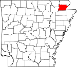
Greene County, Arkansas Basics:


Greene County Arkansas - Government Site

Population: 43,165
Area: 578 square miles
County seat: Paragould
Area code(s) in use: 870
Time zone: CST
High school graduate or higher: 82.2%
Bachelor's degree or higher: 12.5%
Median household income: $38,481
Persons in poverty: 17.3%
Home ownership rate: 64.0%
Mean travel time to work: 20.1 minutes


Adjacent counties:
Clay  Craighead  Dunklin (MO)  Lawrence  Mississippi  Randolph  
Find in Arkansas

Map of the Greene County area


Our detail map of Greene County shows the Greene County, Arkansas boundary lines and other interesting items.

Places in Greene County, Arkansas

  Airports     show all on map

Kirk Field Airport, Quinn Field Airport

  Bridges     show all on map

Eight Mile Creek Bridge, Hopkins Bridge

  Buildings     show all on map

Delaplaine Volunteer Fire Department, Fire Station Number 2, Greene County Courthouse, Greene County Sheriff's Office, Lafe Volunteer Fire Department, Marmaduke Fire Station, Marmaduke Police Department, Northeast Greene County Volunteer Fire Department, Oak Grove Heights Police Department, Oak Grove Heights Volunteer Fire Department, Paragould Childrens Home, Paragould Community Center, Paragould Fire Department Station 1, Paragould Fire Department Station 2, Paragould Fire Department Station 3, Paragould Fire Department Station 4, Paragould Police Department, Paragould-Greene County Jail, Southern Greene County Station 1, Western Greene County Volunteer Fire Department, Wright Memorial Library

  Canals     show all on map

Beaver Dam Ditch, Big Gum Lateral, Big Slough Ditch, Caney Slough, Conley Ditch, Eightmile Ditch, Hurricane Ditch, Johnson Creek Ditch, Lake Ditch, Lateral 4A, Lateral 6 A, Lateral 6 B, Lateral Number 1, Lateral Number 1, Lateral Number 10, Lateral Number 11, Lateral Number 12, Lateral Number 13, Lateral Number 15, Lateral Number 16, Lateral Number 2, Lateral Number 2, Lateral Number 3, Lateral Number 3, Lateral Number 4, Lateral Number 5, Lateral Number 5A, Lateral Number 6, Lateral Number 7, Lateral Number 7, Lateral Number 8, Lateral Number 9, Lateral Number 9, Locust Creek Ditch, Main Canal, Main Ditch, Mayo Ditch, Mud Slough Ditch, Number 26 Ditch, Number 26 Ditch, Petersburg Ditch, Post Oak Ditch, Swan Pond Ditch, Swan Pond Lateral, Village Creek Ditch

  Capes     show all on map

Mitchell Point

  Cemeteries     show all on map

Albrite Cemetery, Beech Grove Cemetery, Bethel Cemetery, Bethel Cemetery, Bonds Cemetery, Browns Chapel Cemetery, Caldwell Cemetery, Center Hill Cemetery, Clarks Cemetery, Coffman Cemetery, Croft Cemetery, Cross Roads Cemetery, Cudd Cemetery, Fairview Cemetery, Finch Cemetery, Finch Cemetery, Friends Cemetery, Gainesville Cemetery, Hartsoe Cemetery, Hartsoe Cemetery, Harveys Chapel Cemetery, Jones Ridge Cemetery, Lafe Cemetery, Liberty Cemetery, Linwood Cemetery, Lorado Cemetery, Memorial Gardens Cemetery, Miller Cemetery, Moore Cemetery, Morrow Cemetery, Mount Zion Cemetery, Mountain Home Cemetery, Old Liberty Cemetery, Parsons Cemetery, Pine Knot Cemetery, Pleasant Grove Cemetery, Pleasant Hill Cemetery, Pruets Chapel Cemetery, Reddick Cemetery, Saint Johns Cemetery, Saint Marys Cemetery, Shady Grove Cemetery, Shiloh Cemetery, Talken Cemetery, Union Grove Cemetery, Warren Cemetery, Woods Cemetery, Wright Cemetery

  Churches     show all on map

Alexander Baptist Church, All Saints Episcopal Church, Beech Grove Methodist Church, Bells Chapel Church, Bethel Baptist Church, Bethel Church (historical), Big Creek Baptist Church, Brighton Baptist Church, Browns Chapel Baptist Church, Browns Church, Calvary Baptist Church, Campground United Methodist Church, Cappadocia Church, Center Hill Baptist Church, Church of God, Church of Jesus Christ, Clarkes Chapel Baptist Church, Commisary Church, Cotton Belt Missionary Baptist Church, Croft Church of Christ, Crossroad Church, Delaplaine Baptist Church, East Side Baptist Church, Ebenezer Church (historical), Eight Mile Baptist Church, Epsaba Baptist Church, Evangelical Friendship Church (historical), Eveland Chapel, Evening Star Church, Fairview Baptist Church, First Assembly of God Church, First Baptist Church, First Christian Church, First General Baptist Church, First Pentecostal Church, First Presbyterian Church, First United Methodist Church, Fontaine Baptist Church, Gainesville Cumberland Presbyterian Church, Gainesville United Methodist Church, Greene County Church, Griffin Memorial United Methodist Church, Harveys Chapel United Methodist Church, Holly Grove Church, Hopewell Missionary Baptist Church, Hurricane United Methodist Church, Immanuel Baptist Church, Lafe Baptist Church, Lake Street Baptist Church, Lambs Church, Liberty Church, Light Baptist Church, Lorado Baptist Church, Mill Town Church, Morning Star Methodist Church (historical), Mount Hebron Church, Mount Hebron Church (historical), Mount Zion Church, Mountain Home Church, Mulberry Church, New 24 Liberty Church, New Friendship Baptist Church, New Home Missionary Baptist Church, New Hope Baptist Church, Nutts Chapel Baptist Church, Oak Grove Heights Baptist Church, Old Bethel Methodist Church, Old Friendship Church (historical), Old Liberty Church, Paragould Christian Church, Pine Knot Church, Pleasant Grove Baptist Church, Pleasant Grove Church, Pleasant Hill Methodist Church, Pleasant Valley Church, Providence Baptist Church, Pruitt Church, Pruitts Chapel, Ramers Chapel United Methodist Church, Redeemer Lutheran Church, Revival Center Pentecostal Church, Rickey Chapel, Robbs Chapel Baptist Church, Rock Hill Baptist Church, Saint Johns Evangelical Lutheran Church, Saint Marks United Methodist Church, Saint Marys Catholic Church, Scatter Creek Methodist Church, Seventh and Mueller Church of Christ, Shady Grove Church, Shiloh United Methodist Church, Spring Grove Church, Stanford Baptist Church, Stanford United Methodist Church, Third Avenue Baptist Church, Tokio Missionary Baptist Church, True Holiness Church of God, Union Church, Union Grove Church (historical), Union Grove Church (historical), Unity Baptist Church, Village Baptist Church, Walls Chapel, Walnut Street Church of Christ, Warrens Chapel United Methodist Church, West View Baptist Church, White Oak Church, Witschieben Presbyterian Church (historical), Woods Chapel Methodist Church

  Cliffs     show all on map

Cypress Point

  Dams     show all on map

Arnolds Lake Dam, Big Creek Site 15 Dam, Big Creek Site One Dam, Big Creek Site Three Dam, Big Creek Site Two Dam, Dickeys Lake Dam, Meadow Lake Dam, Park Lake Dam, Reynolds Park Lake Dam, Thompson Lake Dam, W H Spence Lake Dam

  Guts     show all on map

Gum Slough

  Hospitals     show all on map

Arkansas Methodist Medical Center

  Islands     show all on map

Bark Camp Island, Bear Island, Big Island, Boland Island, Giles Island, Lower Panther Island, Round Island, Upper Panther Island

  Lakes     show all on map

Little Lake, Swagger Slough

  Locales     show all on map

Fox Hills Country Club, Greene County Fairgrounds, Mississippi County Baptist Camp, Mount Zion Baptist Camp, Paragould Country Club, Paragould Industrial Park, Paragould Plaza Shopping Center, Pillows Fish Farm, Stout Spur (historical), Town West Shopping Center

  Parks     show all on map

Alexander Tennis Center, Centennial Station Park, Center Hill Park, Crowley Ridge State Park, Francis Bland Park, Harmon Park, Labor Park, Lake Frierson Primitive Area, Lake Frierson State Park, Reynolds Park, Rotary Park

  Populated Places     show all on map

Bard, Beech Grove, Bertig, Bethel, Black Jack, Brighton, Camp Ground, Case, Case (historical), Center Hill, Coffman, Commissary (historical), Cotton Belt, Crowley, Delaplaine, Dixie, Ebenezer, Evening Star, Fairview, Faulknerville, Finch, Fontaine, Fritz, Gainesville, Green High, Halliday, Hillside (historical), Hooker, Hopewell, Jay, Lafe, Lake Side, Light, Lorado, Marmaduke, Miller, Mitchell Mill, Mollus (historical), Morning Star, Mounds, New Hope, Noxburn, Oak Grove Heights, Paragould, Paris (historical), Pine Knot, Rock Hill, Stanford, Stonewall, Tunis, Twin Oaks, Unity, Walcott, Walnut Corner, White Oak

  Post Offices     show all on map

Beech Grove Post Office, Bula Post Office (historical), Delaplaine Post Office, Light Post Office (historical), Marmaduke Post Office, Paragould Post Office, Stonewall Post Office, Walcott Post Office

  Reservoirs     show all on map

Arnolds Lake, Big Creek Site 15 Reservoir, Big Creek Site One Reservoir, Big Creek Site Three Reservoir, Dickeys Lake, Lake Ashbaugh, Lake Frierson, Meadow Lake, Reynolds Park Lake, Thompson Lake, W H Spence Lake, Walcot Lake

  Ridges     show all on map

Brushy Ridge, Crowleys Ridge, Horse Island Ridge, Jones Ridge, Poplar Ridge, White Oak Ridge

  Schools     show all on map

Alexander School (historical), Baldwin Elementary School, Bard School (historical), Camp Ground School (historical), Center Hill School (historical), Clarks Chapel School (historical), Coffman School (historical), Commissary School (historical), Conley School (historical), Croft Academy (historical), Croft Bible College (historical), Crossroads School (historical), Crowley Ridge Junior College, Crowleys Ridge Academy, Delaplaine Elementary School, Delaplaine High School, Denman School (historical), East Elementary School, Eight Mile School (historical), Elmwood Elementary School, Epsaba School (historical), Evening Shade School (historical), Evening Star School (historical), Friendship School (historical), Fritz School (historical), Green Grove School (historical), Greene County Tech High School, Greene County Tech Intermediate School, Greene County Tech Junior High School, Greene County Tech Primary School, Greene County Technical Junior High School, Halliday School (historical), Hickory Grove School (historical), Lafe Elementary School, Light House School (historical), Light School (historical), Marie Justice Academy (historical), Marmaduke Elementary School, Marmaduke High School, Morning Star School (historical), Mound School (historical), Mount Carmel School (historical), New Home School (historical), New Hope School (historical), Newberry School (historical), Oak Grove Elementary School, Oak Grove Junior High School, Oak Grove Middle School, Oakwood Elementary School, Paragould High School, Paragould Junior High School, Parrish Business College (historical), Pine Knot School (historical), Pleasant Hill School (historical), Post Oak School (historical), Pruitt School (historical), Purcell School (historical), Ramer School (historical), Reddick School (historical), Rice School (historical), Saint Marys School, School Number 44 (historical), School of the 21st Century, South Elementary School, Spring Grove School (historical), Stanford Elementary School, Stanford High School, Talley School (historical), Tech High School, Thompsons Classical Institute (historical), Toddsville School (historical), Tokio School (historical), Tower School (historical), Union Hill School (historical), Upper Lake School (historical), Walls Chapel School (historical), Walnut Corner School (historical), Walnut Ridge School (historical), Welch School (historical), West Elementary School, White Oak School (historical), Woodland School (historical), Woodrow Wilson Elementary School, Woods School (historical)

  Springs     show all on map

Bettis Spring

  Streams     show all on map

Big Creek, Buffalo Head Slough, Culver Creek, Eightmile Creek, Fox Creek, Grassy Slough, Henderson Creek, Hurricane Creek, Jacks Creek, Johnson Creek, Johnson Creek, Jordan Creek, Lick Creek, Lighthouse Creek, Locust Creek, Negro Head Slough, Pigeon Roost Creek, Poplar Creek, Rooker Creek, Scatter Creek, Slavens Creek, Sugar Creek, Village Creek

  Swamps     show all on map

Big Cypress Swamp

  Towers     show all on map

KDRS-AM (Paragould), KDXY-FM (Paragould), KLQZ-FM (Paragould),

Greene County, Arkansas Population By Race (2012 estimate)

RacePopulation
WhiteGreene County White population 41,91341,913  
MixedGreene County Mixed population 561561
BlackGreene County Black population 302302
American IndianGreene County American Indian population 216215
AsianGreene County Asian population 129129
Hawaiian & Pacific IslanderGreene County Hawaiian & Pacific Islander population 00

Additional population tables :
State population table
Arkansas population by county