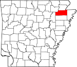
Craighead County, Arkansas Basics:


Craighead County Arkansas - Government Site

Population: 99,920
Area: 707 square miles
County seat: Jonesboro
Area code(s) in use: 870
Time zone: CST
High school graduate or higher: 84.7%
Bachelor's degree or higher: 23.7%
Median household income: $41,054
Persons in poverty: 20.4%
Home ownership rate: 59.6%
Mean travel time to work: 17.5 minutes


Adjacent counties:
Dunklin (MO)  Greene  Jackson  Lawrence  Mississippi  Poinsett  
Find in Arkansas

Map of the Craighead County area


Our detail map of Craighead County shows the Craighead County, Arkansas boundary lines and other interesting items.

Places in Craighead County, Arkansas

  Airports     show all on map

Classic Airstrip, Disinger-Farrville Landing Strip, John Parker Strip, Jonesboro Municipal Airport, Methodist Hospital of Jonesboro Heliport, Nolan Airport, Whited Brothers Landing Strip

  Areas     show all on map

Hackberry Island

  Basins     show all on map

Deasons Lake

  Bridges     show all on map

Logan Bridge, Saint Francis River Bridge

  Buildings     show all on map

Air - Evacuation Lifeteam 2, Arkansas Game and Fish Commission Law Enforcement Northeast Regional Office, Arkansas Services Center, Arkansas State Police Troop C, Arkansas State University Police Department Jonesboro, Bay Fire Department Station 1, Bay Fire Department Station 2, Bay Police Department, Black Oak Volunteer Fire Department, Bono Fire Department Bono Station, Bono Fire Department Center Hill Station, Bono Fire Department Westside Station, Bono Police Department, Booker T Washington Community Center, Brookland Police Department, Brookland Volunteer Fire Department Goobertown Station, Brookland Volunteer Fire Department Greensboro Station, Brookland Volunteer Fire Department Station 2, Buffalo Island Emergency Medical Services, Caraway Police Department, Caraway Volunteer Ambulance Service, Caraway Volunteer Fire Department, Cash Fire Department, Craighead County and Jonesboro Public Library, Craighead County Courthouse, Craighead County Jail, Craighead County Sheriff's Office, Craighead County Sheriff's Office East, Dean B Ellis Library, Egypt Volunteer Fire Department, Emerson Ambulance Service, Federal Bureau of Investigation Jonesboro Resident Office, Jonesboro City Hall, Jonesboro Fire Department Station 2, Jonesboro Fire Station 1, Jonesboro Fire Station 3, Jonesboro Fire Station 4, Jonesboro Fire Station 5, Jonesboro Fire Station 6, Jonesboro Police Department, Lake City Fire Protection District Dixie Station, Lake City Police Department, Lake City Volunteer Fire Main Station, Medic One Ambulance Service Jonesboro, Monette Police Department, Monette Volunteer Fire Department, Philadelphia Fire Department Station 1, Philadelphia Fire Department Station 2, Southridge Fire Department Station 1, Southridge Fire Department Station 2, Valley View Fire Department

  Canals     show all on map

Angle Ditch Lateral Number 4, Ark Slough Ditch, Asher Ditch, Big Bay Ditch, Big Creek Ditch, Big Creek Ditch Main Ditch, Big Creek Lateral Number 1, Big Slough Ditch, Black Fork Ditch, Bohanan Slouth Ditch, Butler Ditch, Cane Island Slough Ditch, Caney Ditch, Cemmons Donick, Cockle Burr Slough Ditch, Ditch Number 1, Ditch Number 10, Ditch Number 2, Ditch Number 2, Ditch Number 2, Ditch Number 3, Ditch Number 3, Ditch Number 3, Ditch Number 32, Ditch Number 4, Ditch Number 5, Ditch Number 5, Ditch Number 6, Ditch Number 6, Ditch Number 6, Ditch Number 60, Ditch Number 7, Ditch Number 7, Ditch Number 8, Ditch Number 8, East Cache River Ditch, Elm Ditch, Emerson Ditch Lateral Number 2, Farley Ditch, Gum Slough Ditch, Gum Slough Ditch, Honey Cypress Ditch Number 4, Johnson Ditch Lateral Number 3, Lateral Number 1, Lateral Number 2, Lateral Number 2 Moores Ditch, Lateral Number 3, Lateral Number 3, Lateral Number 4, Lateral Number 5, Lighthouse Ditch, Little Bay Ditch, Little Ditch Number 3, Little Slough Ditch, Long Pond Or-Cache Ditch, Lost Creek Ditch, Main Ditch, Main Ditch, Main Ditch Number 1, Main Ditch Number 2, Maple Slough Ditch, Marked Tree Floodway, Mound Ditch, Mud Slough Ditch, Taylors Ditch, Thompson Creek Ditch, Viney Slough Ditch, Whaley Slough Ditch, Whitsle Ditch

  Capes     show all on map

White Oak Point

  Cemeteries     show all on map

Bishop Cemetery, Burrow Cemetery, Caldwell Cemetery, Caraway Cemetery, Cooper Cemetery, Culberhouse Cemetery, Gibson Cemetery, Holloway Cemetery, Holy Cross Cemetery, Johnson Cemetery, Jonesboro Memorial Park Cemetery, Kelly Cemetery, Lake City Cemetery, Love Cemetery, Lower Cane Island Cemetery, Macedonia Cemetery, Macy Cemetery, Mangrum Cemetery, McDaniel Cemetery, Mount Pisgah Cemetery, Mount Sinai Cemetery, Nettleton Cemetery, New Haven Cemetery, New Hope Cemetery, Nober Cemetery, Old Trinity Cemetery, Otwell Cemetery, Philadelphia Cemetery, Pine Hill Cemetery, Pine Log Cemetery, Pleasant Grove Cemetery, Rains Cemetery, Ransom Cemetery, Reliford Cemetery, Rock Hill Cemetery, Saint Pauls Cemetery, Sharp Cemetery, Shiloh Cemetery, Sims Cemetery, Straw Floor Cemetery, Sweet Moments Cemetery, Temple of Israel Cemetery, Trinity Cemetery, Union Grove Cemetery, Upper Cane Island Cemetery, White Cemetery, Woodlawn Cemetery, Worley Cemetery

  Churches     show all on map

Alsup Church, Alsup Church, Antioch Church (historical), Baptist Student Center, Beech Grove Church (historical), Bethabara Baptist Church, Bethany Missionary Baptist Church, Bethel Church, Bethel Faith Tabernacle, Big Creek Valley Church, Blessed Sacrement Catholic Church, Bowman Baptist Church, Brookland Church, Brown Church, Buffalo Church, Burnt Hill Church, Caldwell Church, Caraway Church, Carter Temple Christian Methodist Episcopal Church, Center Hill Church, Central Baptist Church, Chilson Chapel, Chilson Church, Christian Valley Church, Church of Christ, Church of Christ, Church of Christ, Church of God, Cothern Church, Cottage Home Church, County Line Church, Cross Road Church, Cross Roads Church, Dixie Baptist Church, Downtown Church of Christ, Earnest Chapel, East Side Baptist Church, Egypt Church, Elm Grove Church, Fairfield Christian Union Church, First Assembly of God Church, First Baptist Church, First Christian Church, First Nazarene Church, First Presbyterian Church, First United Methodist Church, First United Pentecostal Church, Fisher Street Baptist Church, Fisher Street Methodist Church, Forest Chapel (historical), Forest Home Church, Friendly Hope Baptist Church, Friendship Church, Friendship Missionary Baptist Church, Full Gospel Assembly Church, General Church, Gospel Assembly Church, Grace Missionary Church, Hales Chapel (historical), Happy Corner Church, Harmony Church (historical), Hay Memorial Church, Hendrix Chapel (historical), Herget Chapel (historical), Herndon Church, Herndon Church, Hickory Ridge Church, Highland Drive Christian Church, Holy Angels Convent, Huntington Avenue Methodist Church, Immanuel Missionary Church, Interprise Church, Jonesboro Christian Church, Jonesboro Freewill Baptist Church, Jonesboro General Baptist Church, Jonesboro Seventh Day Adventist Church, Kellers Chapel, Kingdom Hall, Kingdom Hall of Jehovahs Witnesses, Lake View United Methodist Church, Liberty Church, Little Texas Church, Lunsford Baptist Church, Macedonia Baptist Church, Macy Church, Mangrum Church, Mount Carmel United Methodist Church, Mount Olive Church, Mount Pisgah Church, Mount Pleasant Church, Needham Church, Needham Church, Nettleton Church of God, Nettleton Methodist Church, New Antioch Baptist Church, New Haven Church, New Haven United Methodist Church, New Hope Baptist Church, New Hope Church, New Hope Church, New Interprise Church, North Main Baptist Church, Oak Grove Church, Oak Ridge Church, Pentecostal Church, Philadelphia Baptist Church, Pilgrim Church, Pine Hill Church, Pine Log Church, Pleasant Grove Church, Pleasant Valley United Methodist Church, Poplar Ridge Chapel, Poplar Valley Church, Prairie Church, Prospect Church, Providence Gum Point Church, Red Church, Reliford Church, Reorganized Church of Jesus Christ of Latter Day Saints, Ridgecrest Baptist Church, Rock Hill Church, Rogers CHapel, Rowes Chapel Baptist Church, Saint Andrews Mission, Saint John Baptist Church, Saint Marks Episcopal Church, Saint Paul Missionary Baptist Church, Saint Pauls African Methodist Episcopal Church, Saint Pauls Church, Saint Pauls United Methodist Church, Schugtown United Methodist Church, Second Presbyterian Church, Shiloh United Methodist Church, Southwest Church, Strawfloor Church, Sunny Valley Church, Sweet Moments Church, Temple Church, Trinity Church, Trinity Methodist Church, Union Grove Church, Union Grove United Methodist Church, United Fellowship of Jonesboro Church, Unity Church, Walnut Grove Church, Walnut Street Baptist Church, Wesleyan Church, Westvale Church, Wood Church, Wood Springs Church, Wood Springs Church

  Crossings     show all on map

Fowler Ford (historical), Logans Ferry (historical)

  Dams     show all on map

Big Creek Site 10 Dam, Big Creek Site 11 Dam, Big Creek Site 13 Dam, Big Creek Site 14 Dam, Big Creek Site 16 Dam, Big Creek Site 17 Dam, Big Creek Site 18 Dam, Big Creek Site 19 Dam, Big Creek Site 20 Dam, Big Creek Site 21 Dam, Big Creek Site 22 Dam, Big Creek Site Eight Dam, Big Creek Site Five Dam, Big Creek Site Four Dam, Big Creek Site Nine Dam, Big Creek Site Seven Dam, Big Creek Site Six Dam, Big Pond Dam, Cole Pond Dam, Craighead Forest Lake Dam, Guy Parden Pond Dam, J L Craft Pond Dam, Mary Simpson Pond Dam, Poinsett Watershed Site 20 Dam, Ralph Cox Pond Dam

  Flats     show all on map

Grapevine Island, Maumelle Prairie, Panther Island, Turkey Island

  Guts     show all on map

Bagwell Slough, Caney Slough (historical), Cottonwood Slough (historical), Dark Slough (historical), Grassy Slough (historical), Ironwood Slough (historical), Overcup Slough (historical), Panther Slough, Spicewood Slough, Tupelo Slough, Turkey Island Slough

  Hospitals     show all on map

HealthSouth Rehabilitation Hospital Jonesboro, Northeast Arkansas Medical Center, Northeast Arkansas Surgery Center, Saint Bernards Behavioral Health Systems, Saint Bernards Medical Center, The Surgical Hospital of Jonesboro

  Islands     show all on map

Big Island, Cane Island, Gum Island, Newton Island, Rush Island, Rush Island, Stave Island

  Locales     show all on map

Airport Center Shopping Center, Airport Industrial Park, Arkansas Childrens Colony, Browns Mill (historical), Caraway Plaza Shopping Center, Chicago Mill (historical), Cole Mill (historical), Craig Hills Public Golf Course, Herman, Highland Square Shopping Center, Indian Mall Shopping Center, Jackson Landing, Jonesboro Country Club, Jonesboro Industrial Development Corporation Industrial Park, Jonesboro Industrial Park, Legacy Landfill, Macey, Millers Store (historical), Northeast District Livestock Show and Fairgrounds, Old Craddock Mill (historical), West Mart Center Shopping Center

  Parks     show all on map

Craighead Forest County Park, Hope Park, Indian Stadium, Northside Park, Saint Francis Sunken Lands State Wildlife Management Area, Southside Softball Complex, Southwest Park, West Washington Avenue Historic District

  Populated Places     show all on map

Aetna, Antioch, Apt, Bay, Black Oak, Bono, Bowman, Brookland, Buck Snort, Bunney, Burnt Hill, Cane Island (historical), Caraway, Cary, Cash, Childress, Chilson, Claunch, Cottonwood Corner, Credit (historical), Davis Spur, Deep Landing, Degelow, Deglow, Delfore, Denton Island, Dixie, Dorothy, Doss (historical), Dryden, Egypt, Elm Grove, Fallis, Farrville, Fiftysix, Fisher, Gibson, Gilkerson, Glendale, Goobertown, Greensboro (historical), Gum Point, Hancock, Hancock Junction, Hergett, Herman, Herndon, Jonesboro, Jonesboro Junction, Lake City, Lake View, Lepanto Junction, Lester, Longwill, Lunsford, Macey, Mangrum, March (historical), Maysville (historical), Monette, Nalle, Needham, Nemo, Nettleton, Oak Ridge, Obear (historical), Otwell, Pauls Switch, Pekin (historical), Philadelphia, Phillips, Pleasant Grove, Poplar Ridge, Ridge, Riggs, Risher, Sandy, Scarb (historical), Schug, Shaw (historical), Smithville (historical), Southland, Sterling Springs, Stier, Three Way, Upper Poplar Ridge, Valley View, Waco (historical), Webbs Mill (historical), Whitburg (historical), Winesburg

  Post Offices     show all on map

Jonesboro Post Office, Nettleton Post Office, State University Post Office

  Reservoirs     show all on map

Big Creek Site 10 Reservoir, Big Creek Site 11 Reservoir, Big Creek Site 13 Reservoir, Big Creek Site 14 Reservoir, Big Creek Site 16 Reservoir, Big Creek Site 17 Reservoir, Big Creek Site 18 Reservoir, Big Creek Site 19 Reservoir, Big Creek Site 20 Reservoir, Big Creek Site 21 Reservoir, Big Creek Site 22 Reservoir, Big Creek Site Eight Reservoir, Big Creek Site Five Reservoir, Big Creek Site Four Reservoir, Big Creek Site Nine Reservoir, Big Creek Site Seven Reservoir, Big Creek Site Six Reservoir, Big Pond, Cole Pond, Craighead Forest Lake, Farmers Lake, Guy Parden Pond, J L Craft Pond, Mary Simpson Pond, Poinsett Watershed Site 20 Reservoir, Ralph Cox Pond

  Ridges     show all on map

Black Oak Ridge, Coopers Ridge, Jimmy Ridge, Old Town Ridge

  Schools     show all on map

56 School (historical), Adams School (historical), Alsup School (historical), Ames School (historical), Annie Camp Junior High School, Annie Camp Middle School, Antioch School (historical), Arkansas State University, Bay Elementary School, Bay High School, Bay-Brown High School, Black Oak School (historical), Blessed Sacrement School, Bono School, Booker T Washington School (historical), Bowman School (historical), Brookland East School, Brookland Elementary School, Brookland High School, Brookland Intermediate School, Brown School (historical), Buffalo Island Central High School, Buffalo Island Central West Elementary, Buffalo Island Central West Elementary School, Burnt Hill School (historical), Casey School (historical), Cash School (historical), Claunch School (historical), Clinton School (historical), Cothran School (historical), Davis Spur School (historical), Decent Lake School (historical), Douglas Macarthur Junior High School, Edgewood School (historical), Egypt School (historical), Elk Grove School, Elm Grove School (historical), Enterprise School (historical), Enterprise School (historical), Fisher School (historical), Forest Home School (historical), Fox Meadow Elementary School, Fox Meadow Intermediate Center, Gilkerson School (historical), Good Luck School (historical), Gray Memorial School, Gubertown School (historical), Gum Point School (historical), Hackaberry School, Hancock School (historical), Herman School (historical), Herman School (historical), Hickory Ridge School (historical), Hillcrest Elementary School, Hope School (historical), Jonesboro Academy (historical), Jonesboro Baptist College (historical), Jonesboro High School, Kerr School (historical), Kindergarten Center School, Lake View School (historical), Lower Mangrum School (historical), Lunsford School (historical), Macey School (historical), Mangrum School (historical), McArthur Middle School, Nettleton Central Elementary School, Nettleton Elementary School, Nettleton High School, Nettleton Intermediate Center School, Nettleton Junior High School, Nettleton Middle School, New Harmony School (historical), New Haven School (historical), New Hope School (historical), New Hope School (historical), North Elementary School, Oak Hill School (historical), Oak Ridge School (historical), Oak Valley School (historical), Philadelphia Elementary School, Phillips School (historical), Pine View School (historical), Pisgah School (historical), Pleasant Grove School (historical), Pleasant Hill School (historical), Pleasant Valley School (historical), Prairie Grove School (historical), Prairie School (historical), Prospect School, Raider Open Door Academy, Red School (historical), Refuge School (historical), Ridge Station School (historical), Riverside East Elementary School, Riverside High School, Riverside Junior High School, Riverside West Elementary School, Rock Hill School (historical), Rogers School (historical), Saint Paul School (historical), Shady Grove School (historical), Shaw School (historical), Sixth Grade Academic Center School, South Elementary School, Special School for Handicapped Children, Trinity School (historical), Tuggle School, Turkey Run School (historical), Union Grove School (historical), University Heights Elementary School, University Hieghts Elementary School, Upper Macey School (historical), Upper Mangrum School (historical), Upper Poplar Ridge School (historical), Valley View Elementary School, Valley View High School, Valley View Junior High School (historical), Wallace School (historical), West 56 School (historical), West Elementary School, West Side High School, Westside Elementary School, Westside Middle School, Woodland College (historical), Yapp School (historical)

  Streams     show all on map

Big Creek, Birch Creek, Bridger Creek, Christian Creek, Coward Slough, Cypress Slu, Davis Branch, Deep Slough, Gunner Slough, Gunner Slough, Higginbottom Creek, Kinnemore Slough, Kirksey Creek, Lost Creek, Maple Slough, Mud Creek, Murray Creek, Podo Creek, Purcell Slough, Rogers Bayou, Rogers Branch, Shelton Creek, Steep Cut Creek, Thompson Creek, Trinity Branch, Whiteman Creek

  Towers     show all on map

KASU-FM (Jonesboro), KBTM-AM (Jonesboro), KDEZ-FM (Jonesboro), KFIN-FM (Jonesboro), KJBR-FM (Jonesboro), KJBR-FM (Jonesboro), KNEA-AM (Jonesboro), KTEJ-TV (Jonesboro), KWEZ-FM (Trumann), KXXA-AM (Monette),

Craighead County, Arkansas Population By Race (2012 estimate)

RacePopulation
WhiteCraighead County White population 82,93482,933  
BlackCraighead County Black population 13,78913,788
MixedCraighead County Mixed population 1,5991,598
AsianCraighead County Asian population 1,0991,099
American IndianCraighead County American Indian population 500499
Hawaiian & Pacific IslanderCraighead County Hawaiian & Pacific Islander population 10099

Additional population tables :
State population table
Arkansas population by county