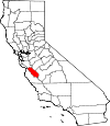
San Benito County, California Basics:


San Benito County California - Government Site

Population: 56,869
Area: 1389 square miles
County seat: Hollister
Area code(s) in use: 831
Time zone: PST
High school graduate or higher: 75.6%
Bachelor's degree or higher: 18.4%
Median household income: $63,939
Persons in poverty: 12.7%
Home ownership rate: 64.3%
Mean travel time to work: 29.3 minutes


Adjacent counties:
Fresno  Merced  Monterey  Santa Clara  Santa Cruz  

Find in California

Map of the San Benito County area


Our detail map of San Benito County shows the San Benito County, California boundary lines and other interesting items.

Places in San Benito County, California

  Airports     show all on map

Christensen Ranch Airport, Frazier Lake Airpark, Hollister Municipal Airport, Pinnacles Ranch Airport

  Areas     show all on map

Badlands, Bolsa, Popeloutchom, San Andreas Rift Zone

  Basins     show all on map

Bitterwater Valley, Browns Valley, Dry Lake Valley, Indian Valley, Rabbit Valley, Round Spring Valley, San Carlos Bolsa, The Hole

  Bends     show all on map

Blue Jay Splash

  Buildings     show all on map

American Medical Response, Bluebird Hotel, Bureau of Land Management Hollister Field Office, Crane House, Department of Forestry and Fire Protection Antelope Station, Department of Forestry and Fire Protection Aromas Tri - County Fire District, Department of Forestry and Fire Protection Bear Valley Fire Station, Department of Forestry and Fire Protection Hollister Station / San Benito County Fire Department, Felipe Gardella House, Galacoma Building, Hollister City Hall, Hollister Community Center, Hollister Fire Department Station 1, Hollister Fire Department Station 2, Hollister School District Office, Jasper Twitchell House, Joe Zbrankik Blacksmith Shop, John Anderson House, Jose Castro House, Juan de Anza Adobe, Kemp House, Lavagnino House, Odd Fellows Hall, Rozas House, Saint Johns Institute (historical), San Benito County Free Library, San Benito County Jail, San Benito County Juvenile Court, San Benito County Law Library, San Benito County Planning Building, San Juan Bautista City Hall, San Juan Bautista City Library, San Juan Bautista Volunteer Fire Department, Taix Block, Theophile Vache Adobe, Tuccoletta Hall, Veterans Memorial Building

  Canals     show all on map

Hollister Conduit, Millers Canal

  Cemeteries     show all on map

Bitterwater Cemetery, Calvary Cemetery, Cherry Hill Cemetery, Clayton Cemetery, Williams-Duckworth Cemetery, Willow Creek Cemetery

  Census     show all on map

Aromas Census Designated Place, Ridgemark Census Designated Place, Tres Pinos Census Designated Place

  Churches     show all on map

Apostolic Full Gospel Church of Christ, Calvary Baptist Church, Church of Christ, Church of God of Prophecy, Community Christian Church, Family Bible Pentecostal Church of God, First Baptist Church (historical), First Presbyterian Church, Full Gospel Tabernacle, Glad Tidings Church, Hollister Church of Christ, Hollister United Methodist Church, Mission San Juan Bautista, Primera Iglesia Bautista del Sur, Sacred Heart Convent, Sacred Heart Roman Catholic Church, Saint Lukes Episcopal Church, Seventh Day Adventist Church, The Church of Jesus Christ of Latter Day Saints, Trinity Lutheran Church

  Cliffs     show all on map

Resurrection Wall, Swanson Bluff, The Bluff

  Crossings     show all on map

Exit 347, Exit 349, Vasquez Crossing

  Dams     show all on map

Bear Gulch Dam, Hawkins 651 Dam, Hernandez 1025-002 Dam, Hollister Waste Pond 1071 Dam, J V De Laveaga 653 Dam, New Idria 657 Dam, Paicines 1025 Dam, Percolation Area 653-002 Dam, Three Corners Dam, Vessey 654 Dam, Wild Oat Dam

  Flats     show all on map

Big Oak Flat, Cedar Flat, Dairy Flat, Lankford Flat, Lewis Flat, Murphy Flat, Orejano Flat, Pretty Flat, Spanish Flats, Star Flat

  Gaps     show all on map

Chittenden Pass, Pajaro Gap, Panoche Pass, Syncline Divide, Three Corners

  Hospitals     show all on map

Hazel Hawkins Convalescent Hospital Sunset, Hazel Hawkins Memorial Hospital, San Benito Health Foundation and Clinic

  Lakes     show all on map

Airstrip Pond, Anzar Lake, Bitterwater Lake, Dry Lake, Dry Lake, Fawn Lake, Hog Hole, Laguna Lake, Lake Tanganyika, Mail Trail Pond, Merrill Lake, Quarry Lake, San Felipe Lake

  Locales     show all on map

Abelardo Cabin, Antelope Fire Control Station, Ashurst Ranch, Bar B Ranch, Bear Gulch Visitor Center, Bear Valley Fire Control Station, Bear Valley Ranch, Beaver Dam Fire Control Station, Buena Vista Ranch, Buffs Ranch, Calhoon Cabin, California Division of Forestry, Chalone Annex Campground, Chalone Creek Campground, Chaparral Campground, Chaparral Overlook, Chileno Camp, Cleveland Ranch, Cygnet Cellars, De Alvarez Ranch, East Entrance Station, Elkhorn Ranch, Enz Vineyards, Fern Chamber, French Ranch, Garcia Rancho, Harrison Cabin, Hawkins Ranch, Hepsedam Ranch, Hollister Business Park, Indart Ranch, John Cabin, John Smith Landfill, Jones Ranch, Kenneth Cabin, Laguna Ranch, Lew Smith Ranch, McCreery Ranch, Melendy Ranch, One Hundred and One Ranch, Ozeki San Benito Winery, Paicines Ranch, Pinnacles Campground, Quien Sabe Ranch, Rancho Las Cimas, Red Corral, Ridgemark Golf and Country Club, Saint Francis Retreat, San Benito County Golf and Country Club, San Benito County Labor Camp, San Benito Mill, San Benito Vineyards, San Juan Oaks Golf Club, Sans Ranch, Schmidt Ranch, Schmidt Ranch, Sparling Ranch, Strohn Rancho, Tannehill Ranch, The Adobe, Thomas Ranch, Thompson Cabin, Thousand Trail Resort, Tully Hall, Wilkinson Ranch

  Military     show all on map

Naval Auxiliary Air Station Hollister (historical)

  Mines     show all on map

Alpine Mine, Ambrose Mine, Asbestos Ridge Mine, Aurora Mine, Bradford Mine, Breen Mine, Camp Two Pit, Clear Creek Mine, Dunne Quarries, Ely Ray Mine, Fireflex Mine, Five Oaks Ranch Pit, Florence Mack Mine, Fourth of July Mine, Gem Mine, Le Grant Mine, Lone Oak Mine, Lucky Strike Mine, Mariposa Mine, Molina Mine, Nash Road Pit, New Idria Mine, Picacho Mine, Saint Thomas Mine, Sampson Mine, San Carlos Mines, Santa Margarita Mine, Spanish Mine, Valley View Mine, Wonder Mine

  Oilfields     show all on map

Vallecitos Oil Field

  Parks     show all on map

Abbe Park, Andy Hardin Stadium, Bear Creek Picnic Area, Bolado Park, Downtown Hollister Historic District, Dunne Memorial Park, Fremont Peak State Park, Hollister Hills State Vehicular Recreation Area, Hollister Wayside Park, McCarthy Park, Pinnacles National Monument, Rancho San Justo Park, San Benito Historical Park, San Juan Bautista Historic District, San Juan Bautista State Historic Park, Veterans Memorial Park, Vista Park

  Pillars     show all on map

Castle Rock, Little Pinnacles, Pinnacle Rocks

  Populated Places     show all on map

Absayruc (historical), Aromas, Asystarca (historical), Bitterwater, Cottage Corners, Dunneville, Duri (historical), Fep (historical), Hollister, Hudner, Idria, Llanada, Logan, Mission Oaks Mobile Home Community, Morse, Mutsun (historical), Orestaco (historical), Paicines, Panoche, Pinnacles, Pouxouoma (historical), Ridgemark, River Oaks, San Benito, San Juan Bautista, Tamarox (historical), Tape (historical), Thithirii (historical), Tipsistaca (historical), Tres Pinos, Vineyard (historical)

  Post Offices     show all on map

Hollister Post Office, Paicines Post Office, San Juan Bautista Post Office, Tres Pinos Post Office

  Ranges     show all on map

Call Mountains, Diablo Range, Gabilan Range, Griswold Hills, Las Aguilas Mountains

  Reserves     show all on map

Pinnacles Wilderness

  Reservoirs     show all on map

Bear Gulch Reservoir, Gloria Lake, Hawkins Lake, Hernandez Reservoir, Paicines Reservoir, San Justo Reservoir

  Ridges     show all on map

Buck Ridge, Cerro Bonito, Chemise Ridge, Cottonwood Ridge, Glaucophane Ridge, Machete Ridge, Pine Ridge, Schoolhouse Ridge, Squire Ridge, The Picachos

  Schools     show all on map

Antelope School (historical), Anzar High School, Apostolic Christian School, Aromas School (historical), Ausaymas School, Bitterwater Tully Elementary School, Calaveras Elementary School, Calvary Christian School, Cerra Vista Elementary School, Chamberlains Acres School, Chamberlains Children Center, Cherry Hill School (historical), Cienega Elementary School, Cottonwood School (historical), Dual Language Academy, Emmett School (historical), Enterprise School, Fairhaven School, Fairview School, Fremont School (historical), Gabilan Hills Elementary School, Gabilan School (historical), Gavilan Community College Hollister Campus, Hernandez School (historical), Hollister Grammar School (historical), Hollister Seventh Day Adventist School, Jefferson Elementary School, Ladd Elementary School, Live Oak School (historical), Marguerite Maze Middle School, Olympia School, Pacheco School, Paicines School (historical), Panoche Elementary School, Pinnacles Community School, Pinnacles School, Quien Sabe School (historical), R O Hardin Elementary School, Rancho San Justo Elementary School, Rancho San Justo Middle School, Sacred Heart Parish School, San Andreas Continuation High School, San Benito Christian School, San Benito County Junior College, San Benito High School, San Juan Elementary School, Santa Ana Alternative Opportunity School, Santa Ana School, Santa Anita School, Southside Elementary School, Spring Grove Elementary School, Sunnyslope Elementary School, Tres Pinos Elementary School, Union School, Vineyard School, Willow Creek School (historical), Willow Grove Elementary school

  Springs     show all on map

Agua Buena Spring, Alba�ez Spring, Ashurst Spring, Buck Spring, Bucks Peak Spring, Cedar Spring, Cottonwood Springs, Dogwood Lateral Six, Dunham Spring, Elkhorn Spring, Fawn Spring, Fitzpatrick Spring, Fourth of July Spring, Fox Spring, Greentree Spring, Hepsedam Spring, Hidden Spring, Horseshoe Spring, Hunter Spring, Lake Spring, Larious Spring, Ligs Spring, Moody Spring, Moses Spring, Mud Spring, Oak Tree Spring, Orejano Spring, Parrot Spring Sulphur, Red Corral Spring, Red Mountain Spring, Rock Spring, Split Oak Spring, Sulphur Spring, Sulphur Spring, Sulphur Springs, Sweetwater Spring, Sylvester Spring, Trough Spring, Wild Oat Springs, Willow Spring, Willow Spring, Willow Spring, Willow Spring

  Streams     show all on map

Antelope Creek, Arroyo De Las Viboras, Arroyo Dos Picachos, Augustine Creek, Bird Creek, Bitterwater Creek, Boulder Creek, Cholla Creek, Clear Creek, De Alvarez Creek, East Fork San Carlos Creek, Garcia Creek, Gorge Creek, Griswold Creek, Harlan Creek, Hepsedam Creek, James Creek, Jamieson Creek, Laguna Creek, Larious Creek, Las Aguilas Creek, Left Fork Bird Creek, Lewis Creek, Lone Tree Creek, Lopez Creek, Los Muertos Creek, Los Pinos Creek, McCoy Creek, Mine Creek, Morellini Creek, North Fork Chalone Creek, North Fork Lewis Creek, Ortega Creek, Pacheco Creek, Payne Creek, Pescadero Creek, Picacho Creek, Pimental Creek, Quien Sabe Creek, Red Mountain Creek, Rock Springs Creek, Salt Creek, Sampson Creek, San Benito River, San Carlos Creek, Santa Ana Creek, Sawmill Creek, South Fork Little Panoche Creek, South Fork Mercy Creek, South Fork Willow Creek, Stone Creek, Sulphur Creek, Sulphuritos Creek, Tequisquita Slough, Thompson Creek, Three Corners Creek, Towne Creek, Tres Pinos Creek, Tully Creek, Vallecitos Creek, Vasquez Creek, West Fork Chalone Creek, Wild Oat Creek, Willow Creek, Willow Spring Creek

  Summits     show all on map

Alta Peak, Balconies, Bald Mountain, Big Mountain, Black Mountain, Buck Peak, Bucks Peak, Cerro Colorado, Cherry Peak, Cibo Peak, Coyote Peak, Cushman Hill, Eagle Mountain, Flint Hills, Fremont Peak, Goat Mountain, Hawkins Peak, Henrietta Peak, Hepsedam Peak, High Peaks, Idria Peak, Jacks Hill, Laguna Mountain, Lomerias Muertas, Lookout Peak, McPhails Peak, Messic Mountain, Meyers Peak, Monolith, Mount Defiance, Mount Harlan, Mount Johnson, Mount Reynolds, North Hill, Panther Peak, Picacho Peak, Pine Mountain, Pine Rock, Pinecate Peak, Pionne Peak, Potrero Peak, Red Mountain, Reinoso Peak, Rock Spring Peak, Sampson Peak, San Benito Mountain, San Carlos Peak, San Joaquin Peak, Santa Ana Mountain, Santa Rita Peak, Scout Peak, Split Rock, Sugarloaf, The Fingers, Three Sisters, Tucker Mountain, Tully Mountain, Vasquez Rock, Walker Peak, Wild Oat Peak, Williams Mountain, Willow Creek Peak

  Towers     show all on map

KMPG-AM (Hollister), KMPG-AM (Hollister)

  Trails     show all on map

Balconies Trail, Bear Gulch Trail, Bench Trail, Condor Gulch Trail, High Peaks Trail, Juniper Canyon Trail, Mail Trail, Moses Spring Trail, North Wilderness Trail, Old Pinnacles Trail, Rim Trail, The Rock Trail, Tunnel Trail

  Valleys     show all on map

Alvisa Canyon, Arroyo Hondo, Azalea Canyon, Babies Gulch, Baker Canyon, Bear Canyon, Bear Canyon, Bear Gulch, Bear Gulch, Bear Valley, Bickmore Canyon, Bitterwater Canyon, Bitterwater Valley, Black Canyon, Bonanza Gulch, Bosworth Canyon, Butterfly Canyon, Byles Canyon, Ca�ada Azul, Ca�ada Verde, Cane Canyon, Cedar Flat Canyon, Cherry Canyon, Cienega Valley, Clough Canyon, Comstock Canyon, Cottonwood Gulch, Coyote Valley, Devils Canyon, Dixon Canyon, Dunham Canyon, George Hansen Canyon, Gloria Valley, Grass Valley, Grassy Canyon, Griswold Canyon, Hell Hole, Hernandez Valley, Hollister Valley, Horse Canyon, Horse Valley, Horsethief Canyon, Horsethief Canyon, Indian Canyon, James Canyon, Johnson Canyon, Larious Canyon, Las Aguilas Canyon, Las Aguilas Valley, Little Quien Sabe Valley, Little Rabbit Valley, Log Cabin Canyon, Long Canyon, Long Gulch, Lorenzo Vasquez Canyon, Los Muertos Valley, McCabe Canyon, McKenna Canyon, Miller Canyon, Mine Canyon, Moody Canyon, Muertos Canyon, New Mill Canyon, Nimrod Canyon, North Canyon, North Fork Oak Canyon, Oat Canyon, Ojeda Canyon, Olivas Canyon, Panoche Valley, Parks Valley, Payne Valley, Peak Canyon, Pimental Valley, Post Canyon, Quien Sabe Valley, Quinn Canyon, Rattlesnake Gulch, Rattlesnake Gulch, Rosas Canyon, Rudolf Canyon, San Juan Canyon, San Juan Valley, Santa Ana Valley, Shields Canyon, Slacks Valley, Smoker Canyon, Steinbeck Canyon, Stone Canyon, Sulphur Canyon, Sulphur Canyon, Swope Canyon, The Gorge, Thompson Valley, Three Troughs Canyon, Topo Valley, Tucker Gulch, Vallecitos, Van Cliff Canyon, Wildcat Canyon, Wildhorse Canyon, Williams Hollow, Williamson Valley

  Wells     show all on map

Eugene Well, New Redford Oil Well,

San Benito County, California Population By Race (2012 estimate)

RacePopulation
WhiteSan Benito County White population 50,44350,442  
MixedSan Benito County Mixed population 1,8771,876
American IndianSan Benito County American Indian population 1,7631,762
BlackSan Benito County Black population 739739
Hawaiian & Pacific IslanderSan Benito County Hawaiian & Pacific Islander population 227227

Additional population tables :
State population table
California population by county