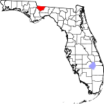
Gadsden County, Florida Basics:


Gadsden County Florida - Government Site

Population: 46,641
Area: 516 square miles
County seat: Quincy
Area code(s) in use: 850
Time zone: EST
High school graduate or higher: 76.8%
Bachelor's degree or higher: 14.0%
Median household income: $35,593
Persons in poverty: 29.5%
Home ownership rate: 70.2%
Mean travel time to work: 28.1 minutes


Adjacent counties:
Calhoun  Decatur (GA)  Grady (GA)  Jackson  Leon  Liberty  Seminole (GA)  

Find in Florida

Map of the Gadsden County area


Our detail map of Gadsden County shows the Gadsden County, Florida boundary lines and other interesting items.

Places in Gadsden County, Florida

  Airports     show all on map

Dogwood Farm Airport, Flat Creek Airport, Florida State Hospital Heliport, Gadsden Memorial Hospital Heliport, Peavy Farms Airport, Quincy Municipal Airport, Rutten Dusting Strip Airport, Saranac Farm Airport, Watson Farm Airport

  Basins     show all on map

Pitts Point

  Bridges     show all on map

Victory Bridge

  Buildings     show all on map

Chattahoochee Fire Department, Concord Volunteer Fire Department, Florida State Hospital Fire Department, Gadsden County Emergency Medical Services Station 1 Headquarters, Gadsden County Emergency Medical Services Station 3, Gadsden County Emergency Medical Services Station 4, Greensboro Volunteer Fire Department, Gretna Volunteer Fire Department, Havana Fire Department, Midway Volunteer Fire Department, Mount Pleasant Volunteer Fire Department, Quincy Fire Department, Robertsville Volunteer Fire Department, Sycamore Volunteer Fire Department, Wetumpka Volunteer Fire Department, Wetumpka Volunteer Fire Department Cooks Landing Substation

  Cemeteries     show all on map

Barber Cemetery, Black Cemetery, Butler Cemetery, Campground Cemetery, Eastern Cemetery, Edwards Cemetery, Farrell Cemetery, Friendship Cemetery, Gause Cemetery, Hopkins Cemetery, Mount Calvary Cemetery, Mount Glory Cemetery, Mount Hosey Cemetery, Mount Pilgrim Cemetery, Mount Pleasant Cemetery, Mount Zion Cemetery, Mount Zion Cemetery, Nicholson-Freeman Cemetery, Owens Cemetery, Pine Grove Cemetery, Poley Branch Cemetery, Saint Hebron Cemetery, Salem Cemetery, Shelfer Cemetery, Smith Cemetery, Smith Cemetery, Sunny Dell Cemetery, Taylor Cemetery, Vickers Cemetery, Western Cemetery, Williams Cemetery, Woodberry Cemetery, Woodland Cemetery

  Churches     show all on map

Antioch Church, Bear Creek Church, Bethlehem Church, Campbell Chapel, Campbell Chapel, China Hill Church, Ebenezer Church, Flat Creek Church, Friendship Church, Galilee Church, Greensboro Church, Hickory Hill Church, Hopewell Church, Little River Church, Little Sycamore Church, Macedonia Church, Mayflower Church, Mount Calvary Church, Mount Glory Church, Mount Hosey Church, Mount Moriah Church, Mount Olive Church, Mount Olive Church, Mount Pilgrim Church, Mount Pleasant Church, Mount Sinai Church, Mount Zion Church, Mount Zion Church, Mount Zion Church, Neals Temple, New Bethel Church, New Zion Church, New Zion Primitive Baptist Church, Peace Church, Philadelphia Church, Pine Grove Church, Piney Grove Church, Pleasant Hope Church, Providence Church, Rich Bay Church, River Hill Church, Saint Elizabeth Church, Saint Hebron Church, Saint James Church, Saint James Church, Saint James Church, Saint John Missionary Baptist Church, Saint Johns Church, Saint Johns Church, Saint Louis Catholic Church, Saint Luke Primitive Baptist Church, Saint Lukes Church, Saint Marks Church, Saint Marys Church, Saint Marys Church, Saint Matthews Church, Saint Pauls Church, Saint Pauls Church, Saint Peters Church, Saint Stevens Church, Shiloh Church, Sycamore Church, Union Chapel, Zion Hope Church

  Cliffs     show all on map

Pine Bluff

  Dams     show all on map

Jim Woodruff Dam

  Harbors     show all on map

Whippoorwill Marina

  Hospitals     show all on map

Florida State Hospital, Florida State Hospital, Gadsden Community Hospital, Gadsden Medical Center

  Lakes     show all on map

A S T Kraysland Pond, Bert Brothers Pond, Byron Sube Mill Pond, C W Thomas Lake, Cecil Butler Lake, Durwood Owens Pond, F J Betts Pond, Gyte Chester Pond, H H Swisher Pond, H M Spooner Pond, Hanno Mill Pond, Henry Dover Pond, J Frank Smith Pond, Lake Tallavana, Lake Yvette, Mary G Munroe Pond, Pitt Land Slide Pond, Violetta Farm Pond

  Locales     show all on map

Altschul Railroad Station, Aspalaga Landing, Bagwell Landing, Boozers Landing, Browns Landing, Camp Star, Centenary Church Camp Grounds, Drakes Landing, Grays Number One Landing, Grays Number Two Landing, High Bluff Landing, Hopkins Landing, Johnsons Landing, Magnet Cove Railroad Station, Miller Camp, Oaklake Village Shopping Center, Quincy Plaza, Rawlings Landing, Smith Landing, Town and Country Shopping Center, Wallwood Boy Scout Camp Reserve

  Mines     show all on map

Gunn Farm Mine

  Parks     show all on map

Bear Creek State Park, Joe Budd Wildlife Management Area, Lake Talquin State Park

  Populated Places     show all on map

Attapulgas (historical), Branchville, Chattahoochee, Concord, Darsey, Dogtown, Douglas City, Ebenezer, Florence, Freemont, Gibson, Greensboro, Gretna, Hardaway, Hardin Heights, Havana, Hiamonee (historical), Hinson, Jamieson, Juniper, Lake View Point, Littman, Lochiocha (historical), Midway, Mount Pleasant, Oak Grove, Ohathlockhouchy (historical), Quincy, Rich Bay, River Junction, Rosedale, Santa Clara, Sawdust, Scotland, Shady Rest, Sycamore, Topkegaiga (historical), Wetumpka

  Reservoirs     show all on map

Hannas Millpond, Interlocking Lakes, J T Budd Pond, Lake Talquin, Shepards Millpond

  Schools     show all on map

Carter-Parramore Junior High School, Chattahoochee Elementary School, Chattahoochee High School, Friendship School, Gadsden Adult Education Center, Gadsden Christian Academy, Greensboro Elementary School, Greensboro High School, Greensboro School, Gretna Elementary School, Havana Day Care Center, Havana Elementary School, Havana Middle School, Havana Northside High School, James A Shanks High School, Love Street School, Mount Pleasant School, Mount Zion School, Munroe School, Pine Park School, Quincy Day School, Quincy High School, Quincy Middle School, Robert F Munroe Day School, Saint Johns School, Springfield School, Stewart Street Elementary School

  Streams     show all on map

Attapulgus Creek, Bear Creek, Billy Branch, Camp Creek, Cane Creek, Clark Branch, Copperhead Branch, Cox Creek, Crooked Creek, Cuban Branch, Double Branch, Double Branch, English Branch, Flat Creek, G Creek, Gulley Branch, Hammock Creek, Hills Creek, Hog Creek, Holley Branch, Holman Branch, Hubbert Branch, Hunter Creek, Hurricane Branch, Hurricane Creek, Jacob Branch, Juniper Branch, Juniper Branch, Juniper Creek, Lewis Creek, Little River, Little Telogia Creek, Long Branch, McDonald Branch, McIntosh Branch, Midway Branch, Mill Creek, Mill Creek, Mill Dam Creek, Monroe Creek, Mosquito Creek, Mule Creek, North Mosquito Creek, Ocklawaha Creek, Pitman Branch, Pole Branch, Quincy Creek, Richlander Creek, Robinson Branch, Rocky Comfort Creek, Salem Branch, Shaw Creek, South Mosquito Creek, Station Branch, Swamp Creek, Sweetwater Branch, Sycamore Branch, Tallahassee Creek, Tanyard Branch, Todd Branch, Turkey Creek, Vote Creek, Willacoochee Creek, Wilson Branch, Winkley Branch, Yon Creek, Yon Creek

  Towers     show all on map

Havana Fire Tower, Quincy Lookout Tower, Rosedale Fire Tower, WFHT-FM (Quincy), WFHT-FM (Quincy), WGWD-FM (Gretna), WMLO-FM (Havana), WMLO-FM (Havana), WTCL-AM (Chattahoochee), WWSD-AM (Quincy),

Gadsden County, Florida Population By Race (2012 estimate)

RacePopulation
BlackGadsden County Black population 25,74625,745  
WhiteGadsden County White population 19,82219,822
MixedGadsden County Mixed population 513513
American IndianGadsden County American Indian population 280279
Hawaiian & Pacific IslanderGadsden County Hawaiian & Pacific Islander population 4746

Additional population tables :
State population table
Florida population by county