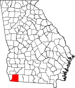
Decatur County, Georgia Basics:


Decatur County Georgia - Government Site

Population: 27,472
Area: 597 square miles
County seat: Bainbridge
Area code(s) in use: 229
Time zone: EST
High school graduate or higher: 78.4%
Bachelor's degree or higher: 13.9%
Median household income: $30,061
Persons in poverty: 28.9%
Home ownership rate: 62.1%
Mean travel time to work: 22.4 minutes


Adjacent counties:
Baker  Gadsden (FL)  Grady  Jackson (FL)  Miller  Mitchell  Seminole  

Find in Georgia

Map of the Decatur County area


Our detail map of Decatur County shows the Decatur County, Georgia boundary lines and other interesting items.

Places in Decatur County, Georgia

  Airports     show all on map

Anderson Airport, Brock Airpark, Corps of Engineers Airport, Decatur County Industrial Air Park, Memorial Hospital Heliport, Vada Airport, Viola Farm Airport, Widdon Airstrip

  Basins     show all on map

Big Rock Sink, Little Rock Sink

  Bends     show all on map

Big Horseshoe Bend, Little Horseshoe Bend

  Bridges     show all on map

Culbreth Bridge

  Buildings     show all on map

Attapulgus Police Department, Bainbridge City Hall, Bainbridge Fire Department Station 2, Bainbridge Police Department, Bainbridge Public Safety Department, Bainbridge Substance Abuse Treatment Center, Beulah Wheat Mission, Climax Police Department, Climax Volunteer Fire Department, Decatur County Correctional Institution, Decatur County Courthouse, Decatur County Fire and Rescue Central Station, Decatur County Fire and Rescue Station 230, Decatur County Fire and Rescue Station 240, Decatur County Fire and Rescue Station 245, Decatur County Fire and Rescue Station 250, Decatur County Fire and Rescue Station 255, Decatur County Fire and Rescue Station 260, Decatur County Fire and Rescue Station 265, Decatur County Fire and Rescue Station 270, Decatur County Fire and Rescue Station 275, Decatur County Jail, Decatur County Sheriff's Department, Potter Street Community Center, Southwest Georgia Regional Library

  Cemeteries     show all on map

Arline Cemetery, Breedlove Cemetery, Brock Cemetery, Butler Cemetery, Cedar Grove Cemetery, Chester Cemetery, Conyers Cemetery, Cool Spring Cemetery, Darsey Cemetery, Fain Cemetery, Fleatown Cemetery, Freeman Cemetery, Green Shade Cemetery, Griffin Cemetery, Hannatown Cemetery, Jackson Cemetery, Jonas Lobe Cemetery, Lane Cemetery, Lewis Cemetery, Lewis Cemetery, Mars Hill Cemetery, Mock Cemetery, Morning Star Cemetery, New Fountainhead Cemetery, Oak City Cemetery, Peterson Cemetery, Pottevint Cemetery, Randolph Cemetery, Rose Lawn Memorial Gardens, Samuel Cemetery, Thompson Cemetery, White Cemetery

  Churches     show all on map

Adams Chapel, Adams Church (historical), Advent Church, Antioch Church, Antioch Church, Antioch Church, Bethany Church, Bethel Church, Bethel Church, Beulah Thomas Church, Black Jack Church, Calvary Baptist Church, Christ Memorial Church, Church of Christ, Church of God (historical), Church of God in Christ, Cool Spring Church, Dry Spring Church, Eldorendo Baptist Church, Emanuel Church, Evangel Temple Assembly of God Church, Fellowship Church, First African Baptist Church of Bainbridge, First Baptist Church, First Born Church, First Christian Church, First Church of the Nazarene, First Independent Methodist Church, First Macedonia Church, First Presbyterian Church, First United Methodist Church, Franklin Church, Friendship Church, Gods Tabernacle, Grant Chapel, Greater Macedonia Baptist Church, Hannatown Church, Highway Church, Hopewell Church, Immanuel Church, John the Baptist Church, Jordan Grove Church, Kingdom Hall, Little Bethel Church, Magnolia Church, Mars Hill Church, Morningside Baptist Church, Mosel Chapel, Mount Ararat Church, Mount Ethel Church, Mount Eunice Church, Mount Gilead Church, Mount Horum Church, Mount Moriah Church, Mount Moriah Church Number 1, Mount Moriah Church Number 2, Mount Nebo Church, Mount Olive Church, Mount Olive Church, Mount Olive Church, Mount Pleasant Church, Mount Pleasant Church, Mount Tabor Church, Mount Zion Church, Mount Zion Church, Mount Zion Church, Mount Zuba Church, Nelson Chapel African Methodist Episcopal Church, New Fountain Head Church, New Home Church, New Jerusalem Church, New Messiah Church, New Messiah Church, New Salem Church, Oak Grove Church, Pilgrim Rest Missionary Baptist Church, Pilgrims Rest Church, Pilgrims Rest Church, Pine Forest Church, Pine Grove Church, Pine Hill Church, Pisgah Church, Pleasant Hill Church, Prosperity Church, Recovery Church, Saint Andrews Church, Saint Johns Episcopal Church, Saint Joseph Catholic Church, Saint Joseph Church (historical), Saint Lukes Church, Saint Mary Church (historical), Saint Marys Church, Saint Matthews Church (historical), Saint Paul Church, Saint Paul Church, Saint Stevens Church, Salem Church, Salem Church, Salem Church, Sanctified Church of the First Born, Sand Bottom Church (historical), Shiloh Church, Smith Grove Church, Smith Grove Church, Star Bethel Church, Sutton Church, Swanwall Church, Sweetwater Church, Sylvania Church, Temple Bethel, Travelers Rest Church, Union Baptist Church, West Bainbridge Baptist Church, West Bainbridge Baptist Church, West Street Baptist Church

  Cliffs     show all on map

Red Bluff

  Crossings     show all on map

Hutchinsons Ferry (historical)

  Dams     show all on map

Coastal Loan Company Lake Dam, Davis Lake Dam, Dubarco Incorporated Lake Dam, Dubarco South Lake Dam, Lake Dubarco Dam, Rich Lake Dam

  Flats     show all on map

Camp Flats, The Level

  Guts     show all on map

Big Slough

  Hospitals     show all on map

Bainbridge Hospital (historical), Bainbridge State Hospital, Griffin Hospital, Memorial Hospital and Manor, Riverside Hospital (historical)

  Islands     show all on map

Bass Island, Fort Scott Island, Perkins Island

  Lakes     show all on map

Avery Pond, Bateau Pond, Black Jack Pond, Black Lake, Buffalo Pond, Buzzard Roost, Cane Water Pond, Cowart Pond, Crescent Lake, Duck Pond, Durham Park, Fountain Pond, Fourmile Pond, Gum Pond, Holder Pond, Lake Douglas, Long Pond, Open Pond, Peter Pond, Silver Lake, Simms Pond, Twin Lakes

  Locales     show all on map

Attapulgus, Bainbridge Mall Shopping Center, Big Slough Boat Landing, Chattahoochee Landing, Commodore Decatur Industrial Park, Decatur County Industrial Air Park, Faceville Landing, Hales Landing, Horseshoe Bend Boat Ramp, Hutchinson Landing, Johnsons Store (historical), L and N Poultry Farm, Old Hatton Ferry Landing, Pattersons Landing, River Junction Landing, Steadhams Store, Ten Mile Still Landing, Town Center Mall Shopping Center, Wyley Landing (historical)

  Military     show all on map

Bainbridge Army Air Field (historical), Fort Scott (historical)

  Mines     show all on map

Englehart Decatur Mine

  Parks     show all on map

Bainbridge Commercial Historic District, Bainbridge Residential Historic District, Bainbridge State Park, Brinson Family Historic District, Chason Park, Cheney Griffen Park, College Street Park, Decatur County Memorial Coliseum, Earle May Park, Helen Street Park, Lake Drive Park, Pineland Drive Park, Washington Street Park, Willis Park

  Populated Places     show all on map

Amsterdam, Attapulgus, Ausmac, Bainbridge, Bethany, Brinson, Climax, Cyrene, Eldorendo, Faceville, Fowlstown, Hannatown, Hanover, Jinks, Laingkat, Lynn, Miriam (historical), Mount Pleasant, Mount Pleasant, Otisco, Parker Courthouse, Recovery, Smiths Landing, Vada, West Bainbridge

  Post Offices     show all on map

Bainbridge Post Office, Fowlstown Post Office, West Bainbridge Post Office

  Reservoirs     show all on map

Coastal Loan Company Lake, Davis Lake, Dubarco Incorporated Lake, Dubarco South Lake, Lake Dubarco, Lake Seminole, Rich Lake, Sholar Pond, Silver Lake

  Schools     show all on map

Attapulgus Academy (historical), Bainbridge Air Base Contract School (historical), Bainbridge Female Academy (historical), Bainbridge High School, Bainbridge Junior College, Bainbridge Junior High School (historical), Bainbridge Male and Female Academy (historical), Bainbridge Masonic Institute (historical), Bell-Dixon School (historical), Christian School Number 1, Christian School Number 2, Climax Elementary School, Dell School, Elcan-King School, Faceville School (historical), Fowlstown Academy (historical), Grants School (historical), Hutto Junior High School, John Johnson School, Jones Wheat School, Lillian E Williams Elementary School, Mount Moriah School (historical), Mount Pleasant School (historical), Oak Academy, Oak Grove School (historical), Parker School (historical), Potter Street Elementary School, West Bainbridge Elementary School, West Bainbridge Middle School, Whittier Normal School (historical)

  Springs     show all on map

Devil Den Springs, Muddy Springs, Shackelford Springs, Whidden Springs, Yates Springs

  Streams     show all on map

Ballou Creek, Betts Mill Creek, Big Slough, Boykin Branch, Butlers Creek, Callahan Branch, Chattahoochee River, Double Branch, Dry Creek, Dry Creek, Flint River, Fourmile Creek, Gin Branch, Ginhouse Creek, Little Attapulgus Creek, Miller Branch, Parramore Creek, Sanborn Creek, Spring Creek, Walker Branch, Yellow Water Branch

  Swamps     show all on map

Fowlstown Swamp

  Towers     show all on map

WMGR-AM (Bainbridge), WYSE-AM (Bainbridge),

Decatur County, Georgia Population By Race (2012 estimate)

RacePopulation
WhiteDecatur County White population 15,35715,356  
BlackDecatur County Black population 11,40111,400
MixedDecatur County Mixed population 275274
American IndianDecatur County American Indian population 220219
AsianDecatur County Asian population 165164
Hawaiian & Pacific IslanderDecatur County Hawaiian & Pacific Islander population 2727

Additional population tables :
State population table
Georgia population by county