Miller County, Georgia Basics:


Miller County Georgia - Government Site

Population: 5,975
Area: 282 square miles
County seat: Colquitt
Area code(s) in use: 229
Time zone: EST
High school graduate or higher: 78.5%
Bachelor's degree or higher: 10.6%
Median household income: $32,432
Persons in poverty: 21.6%
Home ownership rate: 71.2%
Mean travel time to work: 24.0 minutes

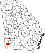
Adjacent counties:
Baker  Decatur  Early  Seminole  

Find in Georgia

Map of the Miller County area


Our detail map of Miller County shows the Miller County, Georgia boundary lines and other interesting items.

Places in Miller County, Georgia

  Buildings     show all on map

Colquitt - Miller County Volunteer Fire Department, Colquitt Police Department, Georgia State Patrol Troop G Post 14 Donalsonville, Miller County Emergency Medical Services, Miller County Jail, Miller County Sheriff's Department, Miller County Volunteer Fire Department Station 2 Babcock Volunteer Fire Department, Miller County Volunteer Fire Department Station 3 - Enterprize Volunteer Fire Department

  Cemeteries     show all on map

Bellview Cemetery, Boykin Cemetery, Colquitt City Cemetery, Cooks Union Cemetery, Cratic Cemetery, Davis Cemetery, Flat Creek Cemetery, Harmony Cemetery, Hornsby Cemetery, Hornsby Cemetery, Kelly Cemetery, Lane Cemetery, Macedonia Cemetery, Mothers Home Cemetery, New Home Cemetery, New Salem Cemetery, Oak Grove Cemetery, Pleasant Hill Cemetery, Pleasant Hill Cemetery, Pond Town Cemetery, Rawls Cemetery, Roberts Cemetery, Sheffield Cemetery, Shepard Cemetery, Swingington Cemetery, Union Cemetery, Union Cemetery, Whites Bridge Cemetery

  Census     show all on map

Boykin Census Designated Place

  Churches     show all on map

Bellview Freewill Baptist Church, Boykin Church of God, Church of Christ, Colquitt Church, Colquitt United Methodist Church, Cooks Union Church, Ebenezer Church, Evergreen Church, First Baptist Church, Flat Creek Church, Harmony Church, Hopewell Church, Kimbell Chapel, Little Zion Church, Macedonia Church, Morning Star Church, Mothers Home Church, Mount Olive Church, Mount Olive Church, New Home Church, New Hope Church, New Salem Church, Oak Grove Free Will Baptist Church, Pilgrims Rest Church, Pine View Baptist Church (historical), Pleasant Hill Church, Pleasant Hill Church, Rocky Ridge Church, Saint Marys Church, Saint Pauls Church, Shiloh Church, South Mount Zion Church, Thompson Church, Union Church, Union Church

  Hospitals     show all on map

Miller County Hospital

  Lakes     show all on map

Big Pond (historical), Byrd Pond, Cecil Lake, Cook Pond, Cow Pen Pond, Davis Pond, Gilbert Lake, Indian Pond (historical)

  Parks     show all on map

Colquitt Town Square Historic District, Miller County Wildlife Management Area

  Populated Places     show all on map

Babcock, Bellview, Boykin, Colquitt, Cooktown, Corea, Dozier (historical), Enterprise, Floydtown (historical), Horns Cross Road (historical), Jeterville, Joe Shingler (historical), Macedonia, Mayhaw, Nicholasville (historical), Spooner (historical), Twilight (historical)

  Schools     show all on map

Griggs School (historical), Grimes School (historical), Hardy School (historical), Harmony School (historical), Jeterville School (historical), Jones-Babcock School (historical), Kaney Head School (historical), McCormick School (historical), McLendon School (historical), Miller County Elementary School, Miller County High School, Miller County Junior High School, Newberry School (historical), Pine Hill School (historical), Porto Rico School (historical), Spooners School (historical), Twilight School (historical), Widners School (historical)

  Streams     show all on map

Acocks Creek, Aycocks Creek, Big Drain, Cypress Creek, Dry Creek, Flat Creek, Kaney Head Creek, Long Branch, Sow Branch, Susian Ford Creek

  Swamps     show all on map

Bush Pond, Full Ford Pond, Middleton Pond, Piney Pond

  Towers     show all on map

WGMK-FM (Donalsonville), WSEM-AM (Donalsonville),

Miller County, Georgia Population By Race (2012 estimate)

RacePopulation
WhiteMiller County White population 4,1534,152  
BlackMiller County Black population 1,6911,690
MixedMiller County Mixed population 7271
AsianMiller County Asian population 4241
American IndianMiller County American Indian population 1817
Hawaiian & Pacific IslanderMiller County Hawaiian & Pacific Islander population 00

Additional population tables :
State population table
Georgia population by county