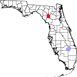
Gilchrist County, Florida Basics:


Gilchrist County Florida - Government Site

Population: 16,859
Area: 350 square miles
County seat: Trenton
Area code(s) in use: 352
Time zone: EST
High school graduate or higher: 79.2%
Bachelor's degree or higher: 11.8%
Median household income: $36,521
Persons in poverty: 21.9%
Home ownership rate: 81.0%
Mean travel time to work: 31.7 minutes


Adjacent counties:
Alachua  Columbia  Dixie  Lafayette  Levy  Suwannee  

Find in Florida

Map of the Gilchrist County area


Our detail map of Gilchrist County shows the Gilchrist County, Florida boundary lines and other interesting items.

Places in Gilchrist County, Florida

  Airports     show all on map

Country Landings Airport, Darrah Air Park, Flying Harness Farms Airport, Fox Field Airport, Oak Tree Landing Airport, Otter Springs Resort Airport, Rush Airport, Saw Whet Farms Airport, Shady Bend Airport, Watson Flight Strip Airport

  Buildings     show all on map

Central Florida Electric Cooperative Neals Substation, Gilchrist County Courthouse, Gilchrist County Emergency Medical Services Medic 1, Gilchrist County Emergency Medical Services Medic 2, Gilchrist County Fire and Rescue Station 1, Gilchrist County Fire and Rescue Station 2, Gilchrist County Fire and Rescue Station 3, Gilchrist County Fire and Rescue Station 4, Gilchrist County Public Library, Gilchrist County School Board, Gilchrist County Sheriff's Office, Trenton Volunteer Fire Department Station 25

  Cemeteries     show all on map

Joppa Cemetery, Mount Horeb Cemetery, Osceola Cemetery, Shady Grove Cemetery, Townsend Cemetery, Trenton Cemetery

  Census     show all on map

Spring Ridge Census Designated Place

  Churches     show all on map

Bell Church, Bethel African Methodist Episcopal Church, Bethel Church, Bethel Church, Center Hill Church, Cherry Sink Church, Community Church of the Nazarene, Ebenezer Baptist Church, Jennings Lake Church, Jesus Way Church of Deliverance, Living Praise Church of God, Midway Church, Mount Horeb Baptist Church, Mount Nebo Church, New Hope Church, Pierce Chapel, Pleasant Grove Church, Pleasant Hill Church, Priscilla Church, Shady Grove Primitive Baptist Church, Trenton Church of Christ, Trenton First Baptist Church, Trenton United Methodist Church, Union Church, Wayfair Church, Westside Church of Christ

  Islands     show all on map

Dry Prairie Hammock

  Lakes     show all on map

Bagget Lake, Bay Horse Pond, Bird Pond, Black Lake, Black Pond, Boat Pond, Bogg Pond, Bone Pond, Bonnet Pond, Bright Lake, Buttonwood Pond, Camp Pond, Cannon Pond, Cannon Pond, Casson Pond, Christmas Lake, Clear Pond, Clear Pond, Coop Pond, Deer Pond, Dinner Pond, Double Pond, Duck Pond, Duck Pond, Fish Pond, Fivemile Pond, Fourmile Lake, Fox Pond, Gator Pond, Goose Pond, Grass Pond, Grass Pond, Half Moon Pond, Haven Winquipin, Hay Pond, Jeb Knight Pond, Jennings Lake, Joppa Lake, Knighting Lake, Lee Lake, Leech Pond, McCain Lake, Mill Pond, Morgan Pond, Negro Pond, Poley Cow Pen, Sampson Lake, Sand Pond, Sapp Lake, Sevenmile Lake, Shirley Lake, Smiths Prairie, Threemile Lake, Tusset Pond, Waccasassa Lake, Wash Pond, Waters Lake, Weeks Lake, Weeks Waterhole, Yard Pond

  Locales     show all on map

Iris Railroad Station, Log Landing, Mona Railroad Station, Rock Bluff Landing, Thames Junction (historical)

  Military     show all on map

Fort White (historical)

  Parks     show all on map

Trenton High School Football Stadium, Trenton State Park

  Populated Places     show all on map

Bell, Blitchville, Craggs, Curtis, Fanning Springs, Harvard, Little Lake City, Lottieville, Mutual, Neals, Thames, Trenton, Tyler, Wanamake, Wannee, Waters Lake, Wilcox, Wilcox Junction, Williford

  Post Offices     show all on map

Trenton Post Office

  Reservoirs     show all on map

Raulison Pond, Spring Pond

  Schools     show all on map

Bell High School, Eagles Nest Private School, Gilchrist Adult Education, John Morse High School (historical), Lancaster Correctional Institution, Suwannee River Research Educational Center, Trenton Elementary School, Trenton Middle-High School

  Springs     show all on map

Bell Springs, Blue Springs, Ginnie Spring, Hart Springs, Lilly Spring, Lumber Camp Springs, Otter Springs, Rock Bluff Spring, Sun Springs

  Streams     show all on map

Cow Creek, Santa Fe River

  Swamps     show all on map

Waccasassa Flats

  Towers     show all on map

Bell Fire Tower, Gilchrist County Lookout Tower, Trenton Water Tower, WCWB-FM (Trenton),

Gilchrist County, Florida Population By Race (2012 estimate)

RacePopulation
WhiteGilchrist County White population 15,49315,493  
BlackGilchrist County Black population 944944
MixedGilchrist County Mixed population 202202
American IndianGilchrist County American Indian population 101101
AsianGilchrist County Asian population 8484
Hawaiian & Pacific IslanderGilchrist County Hawaiian & Pacific Islander population 1716

Additional population tables :
State population table
Florida population by county