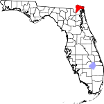
Nassau County, Florida Basics:


Nassau County Florida - Government Site

Population: 74,701
Area: 649 square miles
County seat: Fernandina Beach
Area code(s) in use: 904
Time zone: EST
High school graduate or higher: 88.0%
Bachelor's degree or higher: 22.5%
Median household income: $57,163
Persons in poverty: 11.1%
Home ownership rate: 79.2%
Mean travel time to work: 28.7 minutes


Adjacent counties:
Baker  Camden (GA)  Charlton (GA)  Duval  

Find in Florida

Map of the Nassau County area


Our detail map of Nassau County shows the Nassau County, Florida boundary lines and other interesting items.

Places in Nassau County, Florida

  Airports     show all on map

Baptist Medical Center of Nassau Heliport, Fernandina Beach Municipal Airport, Flying-A-Ranch Airport, Hilliard Airpark, Nassau Airport, Nassau General Hospital Heliport

  Bays     show all on map

Buford Bay, Cumberland Sound

  Bends     show all on map

Cabbage Bend

  Bridges     show all on map

Bell Bridge, Stokes Bridge, Thomas J Shave, Junior, Bridge

  Buildings     show all on map

Callahan Volunteer Fire Rescue Station 5, Fernandina Beach Fire Department Station 1, Fernandina Beach Fire Department Station 2, Fernandina Beach Police Department, Fort Clinch, Hilliard Volunteer Fire Department, Nassau County Criminal Court, Nassau County Detention Center, Nassau County Fire and Rescue Service Headquarters, Nassau County Fire and Rescue Station 10, Nassau County Fire and Rescue Station 20, Nassau County Fire and Rescue Station 30, Nassau County Fire and Rescue Station 3A, Nassau County Fire and Rescue Station 4, Nassau County Fire and Rescue Station 40, Nassau County Fire and Rescue Station 6, Nassau County Fire and Rescue Station 60, Nassau County Fire and Rescue Station 7, Nassau County Fire and Rescue Station 70, Nassau County Fire and Rescue Station 8, Nassau County Fire and Rescue Station 90, Nassau County Sheriff's Department, Nassau County Volunteer Fire and Rescue Station 3, Nassau County Volunteer Fire and Rescue Station 3B, Nassau Oak Volunteer Fire Department Station 11, River Road Community Volunteer Fire Department Station 9

  Capes     show all on map

Johnson Neck, Lofton Point, Seymour Point, Smiths Point

  Cemeteries     show all on map

Bosquebello Cemetery, Braddock Cemetery, Brickyard Cemetery, Conner-Green Cemetery, Deep Creek Cemetery, Haddock Cemetery, Haddock Cemetery, Higginbotham Cemetery, Keen Cemetery, Motes Cemetery, Oakwood Cemetery, Owens Cemetery, Pringle Cemetery, Saint Theresa Cemetery, Wildes Cemetery, Yulee Cemetery

  Census     show all on map

Nassau Village-Ratliff Census Designated Place, Yulee Census Designated Place

  Channels     show all on map

Alligator Creek, City Front Reach, Old Town Reach, Quarantine Reach, Rayonier Reach, Saint Marys Entrance, Seaboard Reach

  Churches     show all on map

Bethel Church, Brandy Branch Church, Buford Grove Church, Chester Missionary Church, Ephesus Church, Gray Gables Church, Harpers Chapel, Live Oak Church, Memorial Church, Mount Horeb Baptist Church, Mount Olive Church, Mount Olive Church, Mount Zion Church, Mount Zion Church, New Hope Church, Pigeon Creek Church, Pine Grove Church, Prince Chapel, Saint James Church, Saint Pauls Church, Saint Peters Church, Spring Hill Church

  Cliffs     show all on map

Orange Bluff, Reids Bluff, Roses Bluff

  Crossings     show all on map

Interchange 373

  Guts     show all on map

Kingsley Creek

  Hospitals     show all on map

Baptist Medical Center Nassau

  Islands     show all on map

Amelia Island, Big Piney Island, Crane Island, Little Tiger Island, Martins Island, Piney Island, Tiger Island

  Lakes     show all on map

Hampton Lake

  Locales     show all on map

Amelia Island Light, Amelia Island Shopping Center, Amelia Plaza, Blood Landing, Bonnet Creek Golf Club, Brickyard Landing, Deland Country Club, Delray Beach Golf Club, Dusdee Willows Poultry Farm, Elbow Landing, Flat Landing, Hawkins Shop Landing, Homer Landing, Jerry Landing, McKenzie Landing, Prospect Landing, Rayonier Fernandina Mill Wharf, Sunowa Springs Camp, Vaughn Landing, Walkers Landing, West Landing, White Sand Landing

  Parks     show all on map

Amelia Island State Park, Cary State Forest, Central Park, Fernandina Plaza Historic State Park, Fort Clinch State Park, Nassau Sound Fishing Pier State Park, Nassau Wildlife Management Area

  Populated Places     show all on map

Amelia City, Amelia Island Mobile Home Park, American Beach, Andrews, Becker, Boulogne, Braddocks Trailer Park, Bryceville, Callahan, Chester, Crandall, Crawford, Dahoma, Dyal, Evergreen, Fernandina Beach, Franklintown, Glenwood, Goodbread Mobile Home Park, Gross, Hedges, Hero, Hilliard, Ingle, Italia, Keene, Kent, Kings Ferry, Lessie, Mattox, Nassau Acres Mobile Home Park, Nassau Village, Nassauville, O'Neil, Old Amelia Mobile Home Park, Old Fernandina, Ratliff, Ruby's Mobile Home Park, Sandpiper Mobile Home Park, Verdie, Yulee, Yulee Heights

  Schools     show all on map

Bryant Academy, Bryceville Elementary School, Callahan Elementary School, Callahan Junior High School, Emma Love Hardee Elementary School, Fernandina Beach High School, Fernandina Beach Junior High School, Hardee Elementary School, Hilliard Elementary School, Hilliard Junior-Senior High School, Junior High School, Peck High School, Saint Josephs Academy, Southside Elementary School, West Nassau Company High School, Yulee Elementary School, Yulee Junior High School

  Streams     show all on map

Alligator Creek, Amelia River, Bells River, Ben Branch, Blounts Branch, Braddock Creek, Brandy Branch, Brush Creek, Cabbage Creek, Christopher Creek, Cossiers Creek, Cross Branch, Cuno Creek, Cushing Creek, Deep Creek, Deep Creek, Deep Creek, Dunn Creek, Egans Creek, Elwood Branch, Funks Creek, Gardner Creek, Harrison Creek, Jackson Creek, Jolly River, Kingsley Creek, Lanceford Creek, Little Boggy Creek, Little Dunn Creek, Little Mills Creek, Little Saint Marys River, Lofton Creek, Lower Sister Creek, Lumber Creek, McQueen Creek, Mill Creek, Mills Creek, Nassau River, Pigeon Creek, Plummer Creek, Saint Joseph Creek, Saint Marys River, Soap Creek, South Amelia River, Stave Branch, Tiger Creek, Upper Sister Creek, Walker Creek

  Summits     show all on map

McClure Hill

  Swamps     show all on map

Brandy Branch Swamp, Cabbage Swamp, Crosby Bay, Little Boggy Swamp, McQueen Swamp, Mesa Marsh, Plummer Swamp, Spell Swamp, Tom Mann Swamp, White Oak Swamp, Wilder Swamp

  Towers     show all on map

WELX-AM (Callahan), WGSR - AM (Fernandina Beach), WNLE-FM (Fernandina Beach), WQAI-AM (Fernandina Beach), WYHI,

Nassau County, Florida Population By Race (2012 estimate)

RacePopulation
WhiteNassau County White population 67,53067,529  
BlackNassau County Black population 4,9304,930
MixedNassau County Mixed population 1,0461,045
AsianNassau County Asian population 747747
American IndianNassau County American Indian population 374373
Hawaiian & Pacific IslanderNassau County Hawaiian & Pacific Islander population 7574

Additional population tables :
State population table
Florida population by county