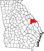
Burke County, Georgia Basics:


Burke County Georgia - Government Site

Population: 23,157
Area: 827 square miles
County seat: Waynesboro
Area code(s) in use: 478 706
Time zone: EST
High school graduate or higher: 75.9%
Bachelor's degree or higher: 9.4%
Median household income: $31,597
Persons in poverty: 30.9%
Home ownership rate: 71.7%
Mean travel time to work: 27.6 minutes


Adjacent counties:
Aiken (SC)  Allendale (SC)  Augusta - Richmond  Barnwell (SC)  Emanuel  Jefferson  Jenkins  Screven  

Find in Georgia

Map of the Burke County area


Our detail map of Burke County shows the Burke County, Georgia boundary lines and other interesting items.

Places in Burke County, Georgia

  Airports     show all on map

Burke County Airport, Midville International Airport, Rhodes Air Ranch Airport, Sandy Hill Airport, Vegp Visitor Center Heliport, Yawn Field

  Bends     show all on map

Devils Elbow, Sandy Hook

  Bridges     show all on map

Cates Bridge, Farmers Bridge, Thompson Bridge, Walkers Bridge

  Buildings     show all on map

Burke County Courthouse, Burke County Emergency Management Agency Engine Company 1, Burke County Emergency Management Agency Engine Company 10, Burke County Emergency Management Agency Engine Company 11, Burke County Emergency Management Agency Engine Company 12, Burke County Emergency Management Agency Engine Company 2, Burke County Emergency Management Agency Engine Company 3, Burke County Emergency Management Agency Engine Company 4, Burke County Emergency Management Agency Engine Company 5, Burke County Emergency Management Agency Engine Company 6, Burke County Emergency Management Agency Engine Company 7, Burke County Emergency Management Agency Engine Company 8, Burke County Emergency Management Agency Engine Company 9, Burke County Jail, Burke County Sheriff's Office, Girard City Hall, Joan Society Hall, Midville Branch Library, Midville City Hall, Midville Police Department, Sardis Branch Library, Sardis Police Department, Sardis Town Hall, Tucker Grove Society Hall, Vogtle Electric Generating Plant, Waynesboro Fire Department, Waynesboro Police Department

  Capes     show all on map

Little Hell Point, Point Comfort

  Cemeteries     show all on map

Alexander Cemetery, Applewhite Cemetery, Bark Camp Cemetery, Beech Branch Cemetery, Bethany Cemetery, Bethel Cemetery, Bethlehem Cemetery, Bines Slave Cemetery, Botsford Cemetery, Brack Cemetery, Brushy Creek Cemetery, Bunn Cemetery, Burke Memorial Gardens, Bynes Grove Cemetery, Casevill Cemetery, Caseville Cemetery, Cason-Bynes Cemetery, Clark Cemetery, Clarks Chapel Cemetery, Coleman Cemetery, Corinth Cemetery, Cross Cemetery, Cullen Cemetery, Foster Cemetery, Freeman Cemetery, George Palmer Cemetery, Godbee Cemetery, Gough Family Cemetery, Gray Family Cemetery, Green Cemetery, Gresham Cemetery, Gresham Cemetery, Heath Cemetery, Hickman Cemetery, Hopeful Cemetery, Hughes Cemetery, Inman Cemetery, Ivory Cemetery, Jenkins Cemetery, Joan Society Cemetery, Keysville Cemetery, Keysville Community Cemetery, Knight Cemetery, Lambert Cemetery, Mallard Cemetery, McBean Cemetery, Midville City Cemetery, Mixon Cemetery, Mixon Cemetery, Moody Cemetery, Mount Zion Cemetery, Murphree Cemetery, Nasworthy Cemetery, Old Church Cemetery, Pet Cemetery, Pol Hill Cemetery, Quinnie Cemetery, Rachael Tucker Cemetery, Red Hill Cemetery, Rocky Creek Cemetery, Rose Dhu Cemetery, Rose Dhu Cemetery, Rosier Cemetery, Saint Paul Cemetery, Sardis Cemetery, Sheppard Place Cemetery, Smith Cemetery, Smith Chapel Cemetery, Smith Family Cemetery, Sycamore Cemetery, Taylor Cemetery, Usher Cemetery, Walker Scott Cemetery, Walter Jones Cemetery, Waynesboro Confederate Memorial Cemetery, White Cemetery, Wimberly Cemetery

  Churches     show all on map

Allens Chapel, Asbury Church, Bark Camp Church, Beech Branch Baptist Church (historical), Beechwood Church, Bells Grove Church, Bethany Church, Bethel Associate Reformed Presbyterian Church (historical), Bethlehem Church, Blackburn Church, Blounts Chapel, Bony Branch Church, Botsford Church, Botsford Church, Brown Grove Church, Brushy Creek Church, Bryants Grove Church, Bynes Chapel, Bynes Grove Church, Canaan Church, Caseville Church, Christian Church (historical), Church of God, Clarks Chapel Church, Cleveland Church (historical), Cochran Grove Church, Cokes Chapel, Corinth Church, Crossroads Church, Daniel Grove Church, Doyle Grove Church, East Burke Church, Ebenezer Church, Ebenezer Church, Fairfield Church, Faith Church, Fellowship Church, Fieldings Grove Church, First Baptist Church, First Baptist Church, First Baptist Church, Florence Church (historical), Friendship Church, Fulwood Church (historical), Givins Grove Church, Gobbie Grove Church, Gordon Chapel, Grays Grove Church, Green Branch Church, Green Grove Church, Greens Cut Church, Hatchers Branch Church, Haven Memorial Church, Holy Church of God, Hopeful Church, Hopeful Church, James Grove Church, Jobs Spring Church, Jones Grove Church, Keys Grove Church, Keysville Evangelistic Church, McBean Church, McBean Church (historical), McClough Grove Church, McCullen Temple, McElmurray Grove Church, McKinney Branch Church, Metropolitan Baptist Church, Mills Grove Church, Mobley Pond Church, Moore Branch Church (historical), Morrison Grove Church (historical), Mount Carmel Church, Mount Olive African Methodist Episcopal Church, Mount Zion Church, Mount Zion Methodist Church (historical), New McCoy Church, Noah's Ark Church, Oak Grove Church, Palmer Grove Church, Peels Grove Church (historical), Phillip Grove Church, Pine Hill Church, Porterville Church, Rays Bridge Church, Red Hill Church, Red Hill Church, Roberson Grove Church, Rocky Creek Church, Rosier Grove Church, Rowland Grove Church, Sacred Heart Church, Saint Antioch Church, Saint Clair Church, Saint Georges Episcopal Church (historical), Saint Johns Church, Saint Johns Church, Saint Marys Baptist Church, Saint Marys Church, Saint Michaels Episcopal Church, Saint Paul Church, Second Canaan Church, Second Springfield Church, Section Grove Church, Smith Chapel (historical), Smith Chapel African Methodist Episcopal Zion Church, Spreadoak Church, Spring Branch Church, Spring Hill Church, Springfield Church, Straight Gate Church, Thankful Baptist Church, Thankful Church, Third Chapel Church, Thomas Grove Baptist Church, Thomas Hill Church, Thompson Bridge Church, Walkers Grove Church, Wards Grove Church, Watkinville Church, Waynesboro Methodist Church, Waynesboro Presbyterian Church, Wesleyan Methodist Church (historical), Williams Grove Church

  Cliffs     show all on map

Blue Bluff, Shell Bluff

  Crossings     show all on map

Demaries Ferry (historical), Dog Ferry (historical), Stoney Bluff Ferry (historical)

  Dams     show all on map

Boyd Lake Dam, Brinson Millpond Dam, Crockett Lake Dam, Davis Pond Dam, Farmer Lake Dam, Fenwick Lake Dam, Fryhofer Lake Dam, Hagler Lake Dam, Jenkins Lake Dam, Johnson Lake Dam, Johnson Pond Dam, Jones Lake Dam, Keys Pond Dam, Knight Irrigation Dam Upper, Knight Lake Dam, Magruder Farms Lake Dam West, McCullough Millpond Dam, Millers Pond Dam, Murray Lake Dam, Prescott Lake Dam, Robinson Lake Dam, Sapp Pond Dam, Shaw Lake Dam, Southland Timber Lake Dam, Telfair Pond Dam, Turkey Pond Dam, Waynesboro Pond Dam, Wells Pond Dam, Wood Pond Dam

  Hospitals     show all on map

Burke Medical Center, Pine Nursing Home

  Lakes     show all on map

Boneyard Lake, Brown Lake, Bunns Lake, Cypress Pond, Gordon Pond, Lamberts Lake, Little Hell Pond, Parkers Lake, Turkey Pond

  Locales     show all on map

Bark Camp, Bells Landing, Brighams Landing, Buxton Landing, Camp Burt Maxwell, Chandler Landing, Daniel Landing, Dog Ferry Landing, Ellisons Landing, Flowery Gap Landing, Fulchers Mill (historical), Greens Cut, Griffins Landing, Hatchers Mill (historical), Hillis Corner, Meeks Store, Mills Store (historical), Rae Old Cowpen (historical), Rouse Store, Sims Landing, Soldiers Field, Southeast Georgia Experiment Station, Stony Bluff Landing, Telfairs Mill (historical), Waynesboro Plaza Shopping Center

  Populated Places     show all on map

Alexander, Asbury (historical), Bellevue, Bill Davis (historical), Brushy Creek (historical), Drone, Dyes Crossroad, Elmore (historical), Gertrude, Girard, Gough, Grove Mount, Hancock Landing, Hatchers Store, Hills Store, Idlewood, Keysville, Le Roy (historical), Magruder, Midville, Munnerlyn, Murray Hill, Number Ten (historical), Old Church, Old Sardis, Rock Fence Crossroads, Rosier, Saint Clair, Sardis, Scotts Corner, Shell Bluff, Shell Bluff Landing, Telfair Woods, Thomas Station, Vidette, Walker Grove Settlement, Waynesboro, Wilsons Store

  Post Offices     show all on map

Gough Post Office, Keysville Post Office, Midville Post Office, Sardis Post Office, Waynesboro Post Office

  Reservoirs     show all on map

Black Lake, Boyd Lake, Brinson Millpond, Burtons Millpond, Crockett Lake, Davis Pond, Farmer Lake, Fenwick Lake, Fryhofer Lake, Goldberg Pond, Gordon Pond, Hagler Lake, Hatchers Millpond, Hillis Pond, Hills Millpond, Hills Pond, Jenkins Lake, Johnson Lake, Johnson Pond, Jones Lake, Keys Pond, Knight Lake, Magruder Farms Lake, Marks Mill Pond, Mash Pond, McCullough Millpond, Miles Pond, Miller Lake, Millers Pond, Murray Lake, Palmers Pond, Peel Pond, Prescott Lake, Red Lake, Robinson Lake, Royal Lake, Sapp Pond, Satchel Pond, Shaw Lake, Shoemaker Lake, Smiths Pond, Southland Timber Lake, Stockton Pond, Storys Millpond, Telfair Pond, Thompsons Pond, Timmons Pond, Turkey Pond, Watkins Pond, Waynesboro Pond, Wells Pond, Wood Pond, Woodwards Pond

  Ridges     show all on map

Clubhouse Ridge

  Schools     show all on map

Alexander Academy (historical), Bargeron School (historical), Bark Camp Academy (historical), Beech Branch School (historical), Beechwood School, Bethesda School (historical), Blakeney Elementary School, Blounts Chapel School, Boggs Academy, Bottsford School (historical), Burke County Comprehensive High School, Burke County High School, Burke County Junior College (historical), Burke County Middle School, Burton School (historical), Campbells School (historical), Carswell School (historical), Clear Spring School (historical), Colson School (historical), Cousins Elementary School, Crossroads Christian School, Cullen School (historical), Cullins School (historical), Days School (historical), Dinkins School, Drone School (historical), Ebenezer School (historical), Edmund Burke Academy, Fairfield School (historical), Florence School (historical), Franklin Academy (historical), Girard Academy (historical), Girard Junior High School, Gordon Hill School (historical), Grays Grove School (historical), Green Grove School, Gresham School (historical), Hammond Academy (historical), Hatchers School (historical), Haven Normal School (historical), Hendricks Academy (historical), Hickory School (historical), Hodgson Institute (historical), Hopeful School, Hudson Hall School, Inman School (historical), Job Spring School (historical), L D Hill School, McBean Academy (historical), Mobley Pond School (historical), Mobley School (historical), Noahs Ark School (historical), Ogeechee Education Center, Palmer Academy (historical), Palmer Elementary School, Phillip Grove School, Pleasant Grove Academy (historical), Pleasant Grove School (historical), Porter School (historical), Quinnie Hall School, Red Hill School (historical), Red Hill School (historical), Red School (historical), Roberson Grove School (historical), Robinson School (historical), Rockville School (historical), Rocky Creek School, Rowland Grove School, Saint Clair School, Saint Paul School (historical), Spring Branch School (historical), Spring Hill School (historical), Springfield School (historical), Thomas School (historical), Walker Academy (historical), Walker Grove School (historical), Waynesboro Elementary School, Waynesboro High School, Waynesboro Mennonite School, Williams Grove School, Winters School (historical)

  Springs     show all on map

Boiling Spring, Palmer Spring

  Streams     show all on map

Allen Branch, Bark Camp Creek, Barton Branch, Bates Branch, Beaver Dam Creek, Beaverdam Creek, Beaverdam Creek, Beedy Branch, Boggy Gut, Boggy Gut Creek, Braswell Branch, Broom Branch, Brushy Creek, Bull Branch, Camp Branch, Chandlers Branch, Chatman Branch, Chickasaw Branch, Clear Spring Creek, Collins Branch, Cox Branch, Daniels Branch, Dry Branch, Dukes Branch, Eightmile Creek, Fitz Branch, Harp Branch, Hatchers Branch, High Head Branch, Hills Branch, Hopeful Branch, Jenkins Branch, Jobs Branch, Lambert Branch, Little Beaverdam Creek, Little Brushy Creek, Little Creek, Little Sweetwater Creek, Looks Branch, Lovett Branch, Maple Branch, Mash Pond Branch, McBean Creek, McIntosh Creek, Mill Branch, Mill Creek, Mill Creek, Mima Branch, Mineral Spring Branch, Mobley Branch, Mount Zion Branch, Nesbitt Branch, Newberry Creek, Old Mill Branch, Palmer Branch, Peters Branch, Poley Branch, Poplar Root Branch, Red Branch, Reubens Branch, Rock Creek, Rock Hill Branch, Rocky Creek, Rocky Creek, Rocky Creek, Rosemary Creek, Roundtree Branch, Sandy Branch, Seals Creek, Slough Branch, Spring Branch, Steiner Branch, Stewart Branch, Stewart Branch, Still Branch, Stocking Branch, Strawberry Branch, Sweetwater Creek, Tarvers Branch, Thornton Creek, Toblers Creek, Travers Branch, Turner Branch, Walnut Branch, Walnut Branch

  Summits     show all on map

High Head, Potlikker Hill

  Swamps     show all on map

Cushner Pond, D'Antignac Swamp, Little Hell

  Towers     show all on map

WAGW-FM (Waynesboro), WBRO-AM (Waynesboro), WYFA-FM (Waynesboro), WYFA-FM (Waynesboro),

Burke County, Georgia Population By Race (2012 estimate)

RacePopulation
BlackBurke County Black population 11,34711,346  
WhiteBurke County White population 11,32411,323
MixedBurke County Mixed population 301301
AsianBurke County Asian population 116115
American IndianBurke County American Indian population 6969
Hawaiian & Pacific IslanderBurke County Hawaiian & Pacific Islander population 2323

Additional population tables :
State population table
Georgia population by county