Jenkins County, Georgia Basics:


Jenkins County Georgia - Government Site

Population: 9,149
Area: 347 square miles
County seat: Millen
Area code(s) in use: 478
Time zone: EST
High school graduate or higher: 69.6%
Bachelor's degree or higher: 13.8%
Median household income: $27,039
Persons in poverty: 29.5%
Home ownership rate: 73.5%
Mean travel time to work: 25.8 minutes

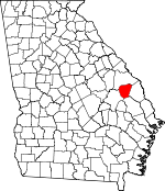
Adjacent counties:
Bulloch  Burke  Emanuel  Screven  

Find in Georgia

Map of the Jenkins County area


Our detail map of Jenkins County shows the Jenkins County, Georgia boundary lines and other interesting items.

Places in Jenkins County, Georgia

  Airports     show all on map

Birdsville Airport, Hacienda de Gay Airstrip Airport, Millen Airport

  Buildings     show all on map

Jenkins Correctional Center, Jenkins County Courthouse, Jenkins County Jail, Jenkins County Sheriff's Department, Millen City Hall, Millen Jenkins County Fire Department, Millen Police Department

  Cemeteries     show all on map

Anderson Cemetery, Aycock Cemetery, Big Buckhead Baptist Church Cemetery, Clifton Cemetery, Drake Cemetery, Fairhaven Cemetery, Finch Cemetery, Green Fork Cemetery, Habersham Cemetery, Lane Cemetery, Lane Cemetery, Lanier Cemetery, Law Cemetery, Lawtonville Cemetery, Little Buckhead Cemetery, Magnolia Cemetery, Paynes Chapel Cemetery, Rocky Branch Cemetery, Wiggens Cemetery, Williams Cemetery, Williams Grove Cemetery

  Census     show all on map

Perkins Census Designated Place

  Churches     show all on map

Anderson Chapel (historical), Bardman Grove Church, Bethel Methodist Episcopal Church, Bethlehem Church, Big Buckhead Baptist Church, Big Horse Creek Church, Carswell Grove Church, Christian Endeavor Hall (historical), Daniel Grove Church, Deep Creek Church, Drakes Chapel, Dry Branch Church, Elam Church, Fair-Haven Church, First Baptist Church, Fountain Springs Church, Friendship Church, Gays Hill Church, Gordon Grove Church, Green Fork Church, Habersham Church, Hurricane Branch Church, Johnson Chapel, Jones Temple, Kelsey Church, Lane Grove Church, Little Buckhead Church (historical), Long Branch Church, Louis Church, Magnolia Church, Millen Baptist Church, Morrison Grove Church, Mount Carmel Church, Mount Carmel Church (historical), Needful Church, Oak Hill Church, Ogeechee Church, Old McCoy Church, Paynes Chapel, Rock Branch Church, Rosemary Church, Saint Matthews Church, Salters Grove Church, Sand Hill Church, Sculls Creek Church, Sculls Creek Number 2 Church, Second Bynes Grove Missionary Baptist Church, Taylor Grove Church, West Millen Baptist Church, Williams Grove Church, Williams Grove Church (historical), Zion Baptist Church, Zion Church (historical)

  Crossings     show all on map

Rogers Crossing

  Dams     show all on map

Brinson Lake Dam, Carswell Lake Dam, Chew Millpond Dam, Davis Lake Dam, Gay Lake Dam, Hendley Pond Dam, Lower Miller Lake Dam, Magnolia Springs State Park Dam, Magnolia View Lake Dam, Milburne Lake Dam, Millen View Lake Dam, Miller Lake Dam, Newton Lake Dam

  Flats     show all on map

Big Sink

  Hospitals     show all on map

Jenkins County Hospital, Millen Hospital, Mulkey Hospital

  Islands     show all on map

Negro Island

  Lakes     show all on map

Big Dukes Pond, Jackson Pond, Jones Pond, Little Dukes Pond

  Locales     show all on map

Bull Hole Landing, Kents Landing, Lane Landing, Magnolia Springs Country Club, Millen National Fish Hatchery, Old Fort Lawton (historical), Pew Landing

  Parks     show all on map

Lincoln State Park, Magnolia Springs State Park

  Populated Places     show all on map

Bennetts Landing, Birdsville, Butts, Cushingville (historical), Emmalane, Four Points, Habersham (historical), Herndon, Lawton, Millen, Paramore Hill, Perkins, Rogers, Scarboro, South Millen (historical), Thrift

  Post Offices     show all on map

Millen Post Office, Perkins Post Office

  Reservoirs     show all on map

Brinson Lake, Carswell Lake, Chew Millpond, Davis Lake, Gay Lake, Hendley Pond, Hendley Pond, Lower Miller Lake, Magnolia Springs State Park Lake, Magnolia View Lake, Milburne Lake, Millen View Lake, Newton Lake

  Schools     show all on map

Buckhead Academy, Dry Branch School (historical), Fairhaven School (historical), Friendship School (historical), Gordons School (historical), Habersham School (historical), Horse Creek School (historical), Jenkins County Elementary School, Jenkins County High School, Jenkins County Middle School, Jenkins County Primary School, Kelsey School (historical), Lewis School (historical), Little Buckhead School (historical), Long Branch School (historical), Needful School (historical), Norwood School (historical), Oak Grove School (historical), Rooty Branch School (historical), Rosenwald School (historical), Sand Hill School (historical), Scarboro School (historical), Souders Grove School (historical), Union School (historical)

  Springs     show all on map

Blue Springs, Magnolia Spring

  Streams     show all on map

Bay Branch, Bee Tree Branch, Billy Branch, Buckhead Creek, Chew Mill Creek, Crooked Branch, Cypress Creek, Deep Creek, Dooley Branch, Dry Branch, Dry Branch, Falling Water Branch, Hooker Branch, Little Buckhead Creek, Long Branch, Middle Pond, Middle Prong Horse Creek, Mill Branch, Mill Creek, Mill Creek, Mill Creek, Oak Cane Branch, Richardson Creek, Rock Branch, Sand Hill Branch, Scarboro Branch, Sculls Creek, Southwell Branch, Spring Mill Branch, Springhead Creek, Storm Branch, The Canal, Wildcat Branch

  Summits     show all on map

Paramore Hill

  Towers     show all on map

WGSR-AM (Millen), WMKO-FM (Millen),

Jenkins County, Georgia Population By Race (2012 estimate)

RacePopulation
WhiteJenkins County White population 4,9954,995  
BlackJenkins County Black population 3,9623,961
MixedJenkins County Mixed population 9191
AsianJenkins County Asian population 4645
American IndianJenkins County American Indian population 3736
Hawaiian & Pacific IslanderJenkins County Hawaiian & Pacific Islander population 1818

Additional population tables :
State population table
Georgia population by county