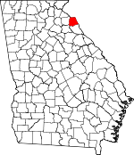
Hart County, Georgia Basics:


Hart County Georgia - Government Site

Population: 25,547
Area: 232 square miles
County seat: Hartwell
Area code(s) in use: 706
Time zone: EST
High school graduate or higher: 79.6%
Bachelor's degree or higher: 15.7%
Median household income: $35,647
Persons in poverty: 23.5%
Home ownership rate: 76.8%
Mean travel time to work: 23.4 minutes


Adjacent counties:
Anderson (SC)  Elbert  Franklin  Madison  Oconee (SC)  

Find in Georgia

Map of the Hart County area


Our detail map of Hart County shows the Hart County, Georgia boundary lines and other interesting items.

Places in Hart County, Georgia

  Airports     show all on map

Airnautique Inc Airport, Mustang Field Airport

  Bars     show all on map

Hatton Shoals (historical)

  Bridges     show all on map

Alfords Bridge (historical), Bakers Bridge, Knox Bridge (historical), Louis Morris Memorial Bridge, Smith-McGee Bridge

  Buildings     show all on map

Hart County Courthouse, Hart County Fire Department Station 1 Central, Hart County Fire Department Station 2 Red Creek, Hart County Fire Department Station 3 Goldmine, Hart County Fire Department Station 4 Shoal Creek, Hart County Fire Department Station 5 Bowersville, Hart County Fire Department Station 6 Nancy Hart, Hart County Fire Department Station 7 Bio, Hart County Fire Department Station 8 Vanna, Hart County Jail, Hart County Library, Hart County Sheriff's Office, Hartwell City Hall, Hartwell City Jail, Hartwell Fire Department, Hartwell Police Department, Whitworth Parole Detention Center

  Cemeteries     show all on map

Berryman Cemetery, Bethany Cemetery, Bethesda Cemetery, Bio Cemetery, Bowers Cemetery, Bowersville City Cemetery, Browns Grove Cemetery, Byrum Cemetery, Cedar Creek Cemetery, Cedar Springs Cemetery, Cleveland Cemetery, Cokesbury Cemetery, Crossroads Cemetery, Fellowship Cemetery, Flat Rock Cemetery, Flat Shoals Cemetery, Gaines Chapel Cemetery, Harmony Grove Cemetery, Hart Memorial Park, Liberty Cemetery, Liberty Hill Cemetery, Macedonia Cemetery, Manly Cemetery, Maret Cemetery, McMullan Cemetery, Memorial Garden of Prayer, Mount Hebron Cemetery, Mount Olivet Cemetery, Mount Olivet Cemetery, Mount Vernon Cemetery, New Harmony Cemetery, New Hope Cemetery, New Light Cemetery, New Prospect Cemetery, North View Cemetery, Oak Bower Cemetery, Old Canon Cemetery, Old Hendry Cemetery, Old Macedonia Cemetery, Old Pleasant Hill Cemetery, Poole Cemetery, Powell Cemetery, Price Chapel Cemetery, Providence Cemetery, Redwine Cemetery, Reed Creek Cemetery, Robertson Cemetery, Rock Springs Cemetery, Rose Hill Cemetery, Roy Cemetery, Ruckers Grove Cemetery, Saint James Cemetery, Saint Johns Cemetery, Sanders Grove Cemetery, Sardis Cemetery, Sardis Cemetery, Sharon Cemetery, Shiloh Cemetery, Shoal Creek Cemetery, Starr Cemetery, Tabernacle Cemetery, Union Hill Cemetery, Vickery Cemetery, Vickery Cemetery, White Cemetery, Williams Cemetery, Zion Cemetery

  Census     show all on map

Eagle Grove Census Designated Place, Reed Creek Census Designated Place

  Churches     show all on map

Bethany Church, Bethesda Church, Bio Church, Calvary Church, Cedar Creek Church, Cedar Springs Church, Cokesbury Church, Cross Roads Baptist Church, Fellowship Methodist Church, Flat Rock Church, Flat Shoals Baptist Church, Gaines Chapel, Goldmine Church, Goldmine Church, Grace Church, Harmony Grove Church, Hartwell Baptist Church, Hartwell Methodist Church, Hendrys Baptist Church (historical), Liberty Church, Liberty Hill Church, Macedonia Church, Milltown Church, Mount Hebron Church, Mount Olivet Church, Mount Olivet Church, Mount Zion Church (historical), New Harmony Methodist Church, New Hope Church, New Light Church, New Prospect Church, Oak Bowen Church, Old Canon Church, Old Salem Methodist Church (historical), Pleasant Hill Church (historical), Price Chapel, Providence Church, Redwine Church, Reed Creek Church, Rock Springs Church, Ruckers Grove Church, Sacred Heart Church, Saint James Church, Saint Johns Church, Sardis Church, Sardis Church, Sharon Church, Shiloh Church, Shoal Creek Church, Tabernacle Church, Union Hill Church, Vanna Chapel, Vernon Church, Zion Church

  Crossings     show all on map

Andersonville Ferry (historical), Averys Ferry (historical), Browns Ferry (historical), Chandlers Ferry (historical), Cleveland Ferry (historical), Coles Ferry (historical), Cooleys Ferry (historical), Crawfords Ferry (historical), Dooleys Ferry (historical), Exit 59, Hatton Ford (historical), Parks Ferry (historical), Sadlers Ferry (historical)

  Dams     show all on map

Beaverdam Creek Structure Number 21 Dam, Beaverdam Creek Structure Number Four Dam, Beaverdam Creek Structure Number Six Dam, Beaverdam Creek Watershed Structure Number 17 Dam, Beaverdam Creek Watershed Structure Number Eight Dam, Beaverdam Creek Watershed Structure Number Five Dam, Cole Dam One, Cole Dam Three, Cole Dam Two, Gunnels Dam, Hartwell Dam, Hartwell Dam

  Hospitals     show all on map

Hart County Hospital, Hartwell Healthcare Center

  Islands     show all on map

Derritt Island, Greens Island, Hewin Island, McMullins Island (historical), Stephenson Island, Weldon Island (historical)

  Locales     show all on map

Ah-yeh-li A-lo-hee (historical), Air Line, Cordell Mill (historical), Hart County Farm, Hartwell Plaza Shopping Center, Hartwell Village Shopping Center, Henley Store (historical), McMullins Mill (historical)

  Mines     show all on map

Taylor Mine

  Parks     show all on map

Benson Street-Forest Avenue Residential Historic District, Bowersville Historic District, Cherokee Memorial, Franklin Street-College Avenue Residential Historic District, Fred E Lee Memorial, Hart Monument, Hart State Park, Hartwell Commercial Historic District, Henrys Church Monument

  Populated Places     show all on map

Amandaville (historical), Bio, Bowersville, Canon, Cross Roads, Eagle Grove, Flat Shoals, Goldmine, Hartwell, Maretts, Monteideo (historical), Mount Olivet, Nuberg, Oak Bower (historical), Parkertown, Parkertown Mill, Reed Creek, Reeds, Royston, Shoal Creek, Vanna

  Post Offices     show all on map

Hartwell Post Office

  Reservoirs     show all on map

Brooks Lake, Cole Lake One, Cole Lake Three, Cole Lake Two, Deans Lake, Gunnels Lake, Hartwell Mica Mine Lake, Rays Lake, Reservoir 17, Reservoir 21, Reservoir Eight, Reservoir Five, Reservoir Four, Reservoir Six, Wilders Pond

  Schools     show all on map

Air Line Elementary School, Bio School (historical), Duncan School (historical), Eagle Grove Elementary School, Goldmine School (historical), Hart County Academy, Hart County High School, Hart County Middle School, Hart-Franklin Training Center for the Disabled, Hartwell Elementary School, Mill Town School (historical), Mount Olivet Elementary School, Nancy Hart School, North Hart Elementary School, Reed Creek School (historical), Shoal Creek Academy (historical), Shoal Creek School (historical), South Hart Elementary School, Viola School (historical)

  Streams     show all on map

Boyds Creek, Caney Branch, Cedar Creek, Clarks Creek, Flat Shoals Creek, Gum Branch, Lightwood Log Creek, Little Beaverdam Creek, Little Cedar Creek, Little Cedar Creek, Little Lightwood Log Creek, Little Shoal Creek, Paynes Creek, Pooles Creek, Pruitt Creek, Reed Creek, Robinson Branch, Shoal Creek, Tugaloo River, Wrights Branch

  Towers     show all on map

WKLY-AM (Hartwell),

Hart County, Georgia Population By Race (2012 estimate)

RacePopulation
WhiteHart County White population 20,08020,079  
BlackHart County Black population 4,8034,802
MixedHart County Mixed population 358357
AsianHart County Asian population 230229
American IndianHart County American Indian population 5151
Hawaiian & Pacific IslanderHart County Hawaiian & Pacific Islander population 00

Additional population tables :
State population table
Georgia population by county