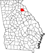
Madison County, Georgia Basics:


Madison County Georgia - Government Site

Population: 27,940
Area: 282 square miles
County seat: Danielsville
Area code(s) in use: 706
Time zone: EST
High school graduate or higher: 75.5%
Bachelor's degree or higher: 13.4%
Median household income: $41,404
Persons in poverty: 19.0%
Home ownership rate: 75.5%
Mean travel time to work: 24.7 minutes


Adjacent counties:
Athens - Clarke  Banks  Elbert  Franklin  Hart  Jackson  Oglethorpe  

Find in Georgia

Map of the Madison County area


Our detail map of Madison County shows the Madison County, Georgia boundary lines and other interesting items.

Places in Madison County, Georgia

  Bridges     show all on map

Fitz Bridge, New Lattice Bridge, Smith Bridge, Wildcat Bridge (historical)

  Buildings     show all on map

Carlton Volunteer Fire Department, Colbert Volunteer Fire Department, Collins District Volunteer Fire Department, Collins District Volunteer Fire Department, Comer Police Department, Comer Volunteer Fire Department, Danielsville Community Volunteer Fire Department, Danielsville Police Department, Georgia Forestry Commission Madison Office, Harrison Volunteer Fire Department, Hull Volunteer Fire Department, Ila Volunteer Fire Department, Madison County Courthouse, Madison County Detention Center, Madison County Emergency Medical Services Station 1, Madison County Emergency Medical Services Station 2, Madison County Emergency Medical Services Station 3, Madison County Emergency Medical Services Station 4, Madison County Sheriff's Office, Neese Sanford Fire Department Station 1, Neese Sanford Fire Department Station 2, Poca Volunteer Fire Department Station 1, Poca Volunteer Fire Department Station 2, Shiloh Volunteer Fire Department

  Cemeteries     show all on map

Adams Cemetery, Allen Cemetery, Bethaven Cemetery, Bradley Cemetery, Bradley Cemetery, Burroughs Cemetery, Chandler Cemetery, Chandler Cemetery, Chandler Cemetery, Chandler Cemetery, Collins Cemetery, Cooper Cemetery, Cooper Cemetery, Crawford Cemetery, Culbertson Cemetery, David Cemetery, Davis Cemetery, Flagham Cemetery, Hill Cemetery, Hitchcock Cemetery, Hix Cemetery, Hix-Williams Cemetery, Kidd Cemetery, Kidd Cemetery, Kincaid Cemetery, McGinnis Cemetery, Meadow Cemetery, Minish Cemetery, Mount Zion Cemetery, Old Fork Cemetery, Perry Cemetery, Pittman Cemetery, Porterfield Cemetery, Powers Cemetery, Shields Cemetery, Smith-Rogers Cemetery, Sorrow-Mann Cemetery, Thompson Cemetery, Thompson Cemetery, Ware Cemetery, White Cemetery, Whitworth Cemetery, Williams Cemetery, Wilson Cemetery

  Churches     show all on map

Bethaben Church, Bethel Church, Bethel Church, Bethel Methodist Church (historical), Bethlehem Church, Black Creek Church, Bluestone Church, Broad River Church, Calvary Temple, Cedar Grove Church, Colbert Baptist Church, Colbert Grove Church, Community Church, Davids Home Church, Diamond Hill Church, Erastus Church, Erastus Church, Fairfield Church, Fairplay Church, Faith Pentecostal Church, Faith Valley Church, Fork Missionary Baptist Church (historical), Freedom Church, Freedom Church, Friendship Church, Galilee Church, Gordons Chapel, Hanna Creek Church, Holly Creek Church, Huff Grove Church, Hull Baptist Church, Ila Baptist Church, Jones Chapel, Kingdom Hall, Liberty Church, Lystria Church, Macedonia Church, Meadow Church, Mill Shoal Church, Montgomery Grove Methodist Church (historical), Moon Grove Church, Moriah Church, Mount Airy Church (historical), Mount Hermon Presbyterian Church (historical), Mount Zion Church, Mount Zion Church, Mount Zion Church, Mount Zion Church, New Haven Church, New Hope Church, New Hope Church, Newtown Church, Oak Grove Baptist Church, Peoples Church, Pleasant Grove Church, Providence Church, Rogers Baptist Church, Rogers Chapel, Shiloh Baptist Church, South River Methodist Church (historical), Tabor Chapel, Trinity Church, Union Church, Vineyard Creek Church, Wagner Grove Church, Wesleys Chapel, Word of Life Church

  Crossings     show all on map

Bonds Ford, Charles Moons Ferry (historical), Daniels Ferry (historical), Deadmans Ferry (historical), Harpers Ferry (historical), Moon Ferry (historical), Moore Ferry (historical), Peytons Ferry (historical), Wilson Ferry (historical)

  Dams     show all on map

Adams Lake Dam, Clark Fain Lake Dam, Glenn Lake Dam, Grimes Dam, Hunnicutt Lake Dam, Irwin Lake Dam, Little Sandy Creek Structure Six Dam, M M Land Development Company Dam, Manley Estate Dam, Morrison Dam, Muse Lake Dam, O'Kelley Dam, Payne Dam, S Bar W Ranch Pond Dam, Sasnett Dam, Seagraves Mill Pond Dam, South Fork Braod River Structure 51 Dam, South Fork Broad River Number 64 Dam, South Fork Broad River Structure 10 Dam, South Fork Broad River Structure 27 Dam, South Fork Broad River Structure 31 Dam, South Fork Broad River Structure 35 Dam, South Fork Broad River Structure 46 Dam, Stoehr Dam, Whitehead Dam, Woods Lake Dam

  Locales     show all on map

Berryman Mill (historical), Brice Drake Chicken Farm, Camp Maranatha, Carruths Mill (historical), Colbert Mill (historical), Comer Mill (historical), Davids Mill (historical), Haggards Crossroad, Mason Mill (historical), O'Kelly Store (historical), Pleasant Grove Community Center, Rogers Mill (historical), Sacred Heart Camp, Seagraves Mill (historical), Smiths Store (historical), Spratling Mill (historical), Thornton Mill (historical)

  Parks     show all on map

Watson Mill State Park

  Populated Places     show all on map

Alvin, Bluestone, Bond, Carlton, Cedar Grove, Colbert, Comer, Dalton, Danielsville, Diamond Hill, Diamond Rock (historical), Dogsboro, Dowdy (historical), Fort Lamar, Gholston Stand Crossroads, Harrison, Hix, Hull, Ila, James Spring (historical), Jeptha, Madison Springs, Minish, Neese, Newtown, Paoli, Patterson, Phillips, Planter, Pocataligo, Porterfield, Rogers, Ross, Sanford, Seagraves, Shiloh, Smiths Store, Transco, Velpoe, Vineyard Creek

  Reservoirs     show all on map

Adams Lake, Clark Fain Lake, Glenn Lake, Grimes Lake, Hunnicutt Lake, Irwin Lake, Lake Seagraves, M M Land Development Company Lake, Manley Estate Lake, Minishs Lake, Morrison Lake, Muse Lake, O'Kelley Lake, Otter Run Lake, Payne Lake, Reservoir 27, Reservoir 29, Reservoir 31, Reservoir 35, Reservoir 51, Reservoir 64, Reservoir Four, Reservoir Six, Reservoir U, S Bar W Ranch Pond, Sandy and Trail Creek Lake, Sandy Creek O Trail Creek Reservoir Number Two, Sanford Lake, Sasnett Lake, Seagraves Mill Pond, Seymours Lake, Stoehr Lake, Whitehead Lake, Woods Lake

  Schools     show all on map

Berryman School (historical), Bluestone School (historical), Bonds Academy (historical), Carithers School (historical), Cleveland School (historical), Colbert Elementary School, Colbert High School (historical), Colbert School, Comer Elementary School, Danielsville Elementary School, Danielsville High School (historical), Duluth School (historical), Eberhart School (historical), Fowlers Academy (historical), Harris School (historical), Harrison School (historical), Hull - Sanford Elementary School, Ila Elementary School, Ila High School (historical), Lilburn School (historical), Madison County High School, Madison County Middle School, Mill Shoal School (historical), Norcross School (historical), Northside School, Oak Grove School (historical), Oakland School (historical), Patterson School (historical), Progress School (historical), Rogers School (historical), South Madison Middle School, Velpoe School (historical), Wrights School (historical)

  Streams     show all on map

Allen Branch, Barnett Branch, Beaverdam Creek, Biger Creek, Bluestone Creek, Brush Creek, Cedar Grove Branch, Double Branch, Dove Branch, Fork Creek, Fortson Branch, Fowler Branch, Furnace Creek, Hanna Creek, Hog Branch, Holly Creek, Hubbard Creek, Kelly Creek, Lamar Creek, Lindsey Branch, Little Black Creek, Little Scull Shoal Creek, Long Branch, Masons Mill Creek, Mill Shoal Creek, Mill Shoal Creek, Muddy Branch, North Fork Double Branch, Nowhere Branch, Rocky Branch, Rocky Shoals Creek, Scull Shoal Creek, Shiloh Creek, South Creek, South Fork Double Branch, Strickland Branch, Vineyard Creek, Ward Branch, Williams Creek, Wolf Branch

  Towers     show all on map

WBIC-AM (Royston), WNGC-FM (Athens), WPUP-FM (Royston), WPUP-FM (Royston),

Madison County, Georgia Population By Race (2012 estimate)

RacePopulation
WhiteMadison County White population 24,81124,810  
BlackMadison County Black population 2,4592,458
MixedMadison County Mixed population 335335
AsianMadison County Asian population 224223
American IndianMadison County American Indian population 8483
Hawaiian & Pacific IslanderMadison County Hawaiian & Pacific Islander population 00

Additional population tables :
State population table
Georgia population by county