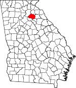
Jackson County, Georgia Basics:


Jackson County Georgia - Government Site

Population: 60,497
Area: 340 square miles
County seat: Jefferson
Area code(s) in use: 706
Time zone: EST
High school graduate or higher: 79.9%
Bachelor's degree or higher: 18.7%
Median household income: $53,393
Persons in poverty: 15.6%
Home ownership rate: 76.8%
Mean travel time to work: 29.3 minutes


Adjacent counties:
Athens - Clarke  Banks  Barrow  Franklin  Gwinnett  Hall  Madison  Oconee  

Find in Georgia

Map of the Jackson County area


Our detail map of Jackson County shows the Jackson County, Georgia boundary lines and other interesting items.

Places in Jackson County, Georgia

  Airports     show all on map

Aiken Field Airport, Doug Bolton Field Airport, Jackson County Airport, Lanier Airport

  Bars     show all on map

Hurricane Shoal, Talassee Shoals

  Bridges     show all on map

Candler Bridge, Double Bridges, Joseph A Johnson Bridge, Long Bridge, Talassee Bridge (historical), Woods Bridge

  Buildings     show all on map

Arcade Police Department, Arcade Volunteer Fire Department, Braselton Police Department, Commerce City Hall, Commerce Police Department, Commerce Public Library, Commerce Volunteer Fire Department, Crawford W Long Medical Museum, Harrisburg Fire Department, Hoschton Police Department, Jackson County Administration Building, Jackson County Correctional Institution, Jackson County Courthouse, Jackson County Jail, Jackson County Senior Citizen Center, Jackson County Sheriff's Office, Jackson Trail Volunteer Fire Department, Jefferson City Hall, Jefferson Fire Department, Jefferson Police Department, Jefferson Public Library, Maysville Area Volunteer Fire Department, Nicholson Area Volunteer Fire Department, Nicholson Area Volunteer Fire Department Station 2, North Jackson Fire Department Station 1, North Jackson Fire Department Station 2, North Jackson Fire Department Station 3, Pendergrass Police Department, Plainview Volunteer Fire Department, South Jackson Fire Department Station 2, South Jackson Volunteer Fire Department, West Jackson County Fire Department

  Cemeteries     show all on map

Academy Cemetery, Antioch Cemetery, Apple Valley Cemetery, Attica Cemetery, Bennett Cemetery, Benton Cemetery, Berea Cemetery, Bethany Cemetery, Bethlehem Cemetery, Braselton Cemetery, Braselton City Cemetery, Cabin Creek Cemetery, Cave Springs Cemetery, Center Cemetery, Center Cemetery, Center Grove Cemetery, Crooked Creek Cemetery, Damron Cemetery, Diamond Hill Cemetery, Dosters Cemetery, Dry Pond Cemetery, Dry Pond Cemetery, Dunson Cemetery, Ebenezer Cemetery, Faith Cemetery, Galilee Cemetery, Gray Hill Cemetery, Gum Springs Cemetery, Harmony Cemetery, Harris-Lord Cemetery, Holiday Cemetery, Holly Springs Cemetery, Hoschton City Cemetery, Howington Cemetery, Jackson Memorial Park, Lebanon Cemetery, Lyle Cemetery, Maxie Hill Cemetery, Mizpah Cemetery, Mount Olive Cemetery, Mount Tabor Cemetery, Mountain Creek Cemetery, New Harmony Cemetery, New Hope Cemetery, New Salem Cemetery, Nicholson City Cemetery, Niemmo Cemetery, Oak Grove Cemetery, Oconee Cemetery, Pendergrass City Cemetery, Pond Fork Cemetery, Poplar Springs Cemetery, Redstone Cemetery, Revival Cemetery, Riverside Cemetery, Rogers Cemetery, Smith Cemetery, Stapler Cemetery, Stone Cemetery, Summer Hill Cemetery, Talmo Cemetery, Thyatira Cemetery, Unity Cemetery, Walnut Fork Cemetery, Wheeler Cemetery, White Cemetery, White Plains Cemetery, Wilson Cemetery, Wilson Cemetery, Woodbine-Jefferson City Cemetery, Zion Cemetery

  Churches     show all on map

Academy Missionary Church, Antioch Church, Apple Valley Baptist Church, Arcade Mission, Arcade Presbyterian Church, Archers Grove Church, Attica Baptist Church, Berea Church, Bethany Church, Bethlehem Church (historical), Brockton Road Church, Cabin Creek Church, Calvary Church, Cave Springs Church, Cedar Grove Church, Center Church, Center Grove Church, Center Methodist Church, Center Union Church, Church of Prophecy, Crooked Creek Church, Crooked Creek Church, Diamond Hill Church, Dry Pond Methodist Church, Ebenezer Church, Faith Church, First Baptist Church, First Christian Church, First Methodist Church, First Presbyterian Church, Full Gospel Tabernacle, Galilee Church, Gum Springs Church, Harmony Christian Church, Holly Springs Church, Hope Haven Mission, Hurricane Grove Church, Jones Chapel, Lebanon Church, Liberty Church, Little Valley Church, Maxies Hill Church, Mizpah Church, Mount Olive Church, Mount Tabor Church, Mountain Creek Church, New Harmony Church, New Hope Church, New Liberty Church, New Salem Church, Niemno Church, Oak Grove Church, Oak Road Church, Oconee Church, Peeks Chapel, Pendergrass Baptist Church, Pommerhill Church, Pond Fork Church, Poplar Springs Church, Redstone Church, Revival Baptist Church, Riverside Church, Sardus Church, Solid Rock Church, Talmo Baptist Church, Thyatira Church, Thyatira Church, Thyatira Presbyterian Church, Toney Hill Church, Unity Christian Church, Victory Church, Walnut Fork Church, White Plains Church, Wilson Church, Zion Church

  Crossings     show all on map

Exit 49, Exit 50, Exit 51, Exit 52

  Dams     show all on map

Bishop Dam, Bishops Lake Dam, Carr Lake Dam, Crowes Lake Dam, Davis Lake Dam, Factory Pond Dam, Hills Lake Dam, Hoods Lake Dam, Iveys Lake Dam, Jarrett Lake Dam, Jefferson City Lake Dam, Johnsons Lake Dam, Lake Jarekit Dam, Lake Yamacutah Dam, Marlow Lake Dam, Middle Oconee Walnut Creek 16 Dam, Middle Oconee Walnut Creek 19 Dam, Middle Oconee-Walnut Creek 15 Dam, Middle Oconee-Walnut Creek 18 Dam, Middle Oconee-Walnut Creek Number 12 Dam, Middle Oconee-Walnut Creek Number 17 Dam, Middle Oconee-Walnut Creek Six Dam, Samples Lake Dam, Sandy Creek Structure 12 Dam, Sandy Creek Structure 14 Dam, Sandy Creek Structure 15 Dam, Sandy Creek Structure 18 Dam, Sandy Creek Structure 23 Dam, Sandy Creek Structure Eight Dam, Terry Dam, Weaver Lake Dam, Williamsons Lake Dam

  Hospitals     show all on map

Banks - Jackson - Commerce Medical Center, Hillcrest-Allen Clinic and Hospital (historical)

  Locales     show all on map

Commerce Country Club, Commerce Waterworks, Flanagans Mill (historical), Fowlers Mill (historical), Holder Plantation, Hoods Mill (historical), Jackson County Farm (historical), Molder Camp, Sells Mill (historical)

  Parks     show all on map

Commerce City Park, Commerce Commercial Historic District, Hoschton Recreation Park, Hurricane Shoals County Park, Jackson Trail Monument

  Populated Places     show all on map

Apple Valley, Arcade, Attica, Braselton, Brockton, Center, Clarksboro, Commerce, Constantine, Dry Pond, Ednaville, Fairview, Goochville, Grove Level, Hamilton Trailer Park, Harmony (historical), Holders, Holly Springs, Hoschton, Hurricane Shoals (historical), Jefferson, Marcus (historical), Nicholson, Pendergrass, Pond Fork (historical), Red Stone, Sells, Talassee (historical), Talmo, Thurmack, Thyatira

  Post Offices     show all on map

Jefferson Post Office

  Reservoirs     show all on map

Bishop Lake, Bishops Lake, Carr Lake, Crowes Lake, Crows Lake, Davis Lake, Factory Pond, Hills Lake, Hoods Lake, Iveys Lake, Jarrett Lake, Jefferson City Lake, Johnsons Lake, Lake Jarekit, Lake Uamacutah, Lake Yamacutah, Marlow Lake, Reservoir 12, Reservoir 12, Reservoir 14, Reservoir 15, Reservoir 15, Reservoir 16, Reservoir 17, Reservoir 18, Reservoir 18, Reservoir 19, Reservoir 23, Reservoir 33, Reservoir Eight, Reservoir Six, Samples Lake, Terry Lake, Weaver Lake, Williamsons Lake

  Schools     show all on map

Academy School (historical), Adams School (historical), Archers Grove School (historical), Bachelors School (historical), Benton Elementary School, Bryan School, Center Union School (historical), Collins School (historical), Commerce Elementary School, Commerce High School, Commerce Junior High School, Commerce Middle School, Commerce Primary School, County High School, Diamond Hill School (historical), East Jackson Comprehensive High School, East Jackson Elementary School, East Jackson Middle School, Elmwood School (historical), Fairview School (historical), Gordon Street Center, Gum Spring School (historical), Gum Springs Elementary School, Hardaman Heights School (historical), Harmony School (historical), Hoods Academy (historical), Jackson County High School, Jackson County Middle School, Jackson Trail Christian School, Jarrets Academy (historical), Jefferson Academy, Jefferson Elementary School, Jefferson High School, Jefferson Middle School, Kings Bridge Middle School, Lords Corner School (historical), Maxeys Hill School (historical), Maysville Elementary School, New Virgil School (historical), North Jackson Elementary School, Orrs School (historical), Plainview School (historical), Pond Park School (historical), Prospect Academy (historical), Red Stone School (historical), South Jackson Elementary School, Union Hill School (historical), Unity School (historical), Victory Hill School (historical), West Jackson Intermediate School, West Jackson Middle School, West Jackson Primary School, Wheeler School (historical)

  Streams     show all on map

Banigan Branch, Borders Creek, Buffalo Creek, Cabin Creek, Candler Creek, Crooked Creek, Cubb Creek, Curry Creek, Dosters Creek, East Fork Pond Fork, Gravelly Creek, Hardeman Creek, Holders Creek, Indian Creek, Little Curry Creek, Little Gravelly Creek, Little Sandy Creek, Lott Creek, Mill Branch, Mountain Creek, Opossum Creek, Parks Creek, Persimmon Branch, Pond Fork, Redstone Creek, Riley Branch, Shankles Creek, Stockton Creek, Turkey Creek

  Towers     show all on map

WBKZ-AM (Jefferson), WJJC-AM (Commerce), WNGM-TV (Athens),

Jackson County, Georgia Population By Race (2012 estimate)

RacePopulation
WhiteJackson County White population 54,02454,023  
BlackJackson County Black population 4,2954,295
AsianJackson County Asian population 1,0891,088
MixedJackson County Mixed population 907907
American IndianJackson County American Indian population 181181
Hawaiian & Pacific IslanderJackson County Hawaiian & Pacific Islander population 6060

Additional population tables :
State population table
Georgia population by county