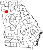
Paulding County, Georgia Basics:


Paulding County Georgia - Government Site

Population: 144,920
Area: 312 square miles
County seat: Dallas
Area code(s) in use: 770
Time zone: EST
High school graduate or higher: 88.1%
Bachelor's degree or higher: 23.0%
Median household income: $63,190
Persons in poverty: 10.3%
Home ownership rate: 82.0%
Mean travel time to work: 37.4 minutes


Adjacent counties:
Bartow  Carroll  Cobb  Douglas  Fulton  Haralson  Polk  

Find in Georgia

Map of the Paulding County area


Our detail map of Paulding County shows the Paulding County, Georgia boundary lines and other interesting items.

Places in Paulding County, Georgia

  Airports     show all on map

Paulding Memorial Hospital Heliport, Paulding Northwest Atlanta Airport, Pinewood Airport

  Bridges     show all on map

Archibald Holland Bridge, George H McMillan Bridge, Judge W A Foster Junior Bridge

  Buildings     show all on map

Braswell Police Department, Dallas City Hall, Dallas Police Department, Hiram Police Department, Maude P Ragsdale Library, Paulding County Administration Building, Paulding County Animal Shelter, Paulding County Board of Education Headquarters, Paulding County Chamber of Commerce, Paulding County Courthouse, Paulding County Fire and Rescue Bureau Station 2, Paulding County Fire and Rescue Bureau Station 3, Paulding County Fire and Rescue Bureau Station 4, Paulding County Fire and Rescue Bureau Station 5, Paulding County Fire and Rescue Bureau Station 6, Paulding County Fire and Rescue Bureau Station 7, Paulding County Fire and Rescue Bureau Station 8, Paulding County Fire and Rescue Bureau Training Facility, Paulding County Health Department, Paulding County Jail, Paulding County Library, Paulding County Sheriff's Office, Paulding County Station 9 Fire Station, Paulding County Water and Sewer Department, Paulding Probation Detention Center, Paulding Regional Youth Detention Center, Paulding Station 1 Fire Station

  Cemeteries     show all on map

Antioch Cemetery, Bethel Cemetery, Beulah Cemetery, Cochran Ridge Cemetery, Concord Cemetery, Cross Roads Cemetery, Dallas Cemetery, Davis Cemetery, Flint Hill Cemetery, Friendship Cemetery, Friendship Cemetery, Gann Cemetery, Harmony Grove Cemetery, Harmony Grove Cemetery, High Shoals Cemetery, Holly Springs Cemetery, Melrose Cemetery, Mount Moriah Cemetery, Mount Tabor Cemetery, Mount Vernon Cemetery, Mount Zion Cemetery, Mount Zion Cemetery, Mount Zion Cemetery, Narroway Cemetery, Nebo Cemetery, New Canaan Cemetery, New Harmony Cemetery, New Hope Cemetery, Old High Shoals Cemetery, Old Shady Grove Cemetery, Old Shady Grove Cemetery, Pine Log Cemetery, Poplar Springs Cemetery, Shady Grove Cemetery, Smyrna Cemetery, Star of Bethlehem Cemetery, Sweetwater Cemetery, Union Cemetery, Vernon Cemetery, White Oak Springs Cemetery, Willow Springs Cemetery, Yorkville Cemetery, Zion Cemetery

  Churches     show all on map

Allgood Church, Antioch Church, Bethany Church, Bethel Church, Beulah Land Baptist Church, Braswell Church, Burnt Hickory Church, Cochran Ridge Church, Concord Church, Cross Roads Church, Cross Roads Church, Crossroads Memorial Church, Dallas Church of God, East Hiram Church, Edgefield Church, Emanuel Church, First Baptist Church of Dallas, Flint Hill Church, Friendship Church, Friendship Church, Full Gospel Mission, Great Commission Fellowship, Happy Valley Church, Harmony Grove Church, Harmony Grove Church, Harper Lake Church, High Shoals Church, Hiram Church, Hiram Paulding Church of God, Hiram Seventh Day Adventist Church, Holly Springs Church, Macedonia Church, Maranatha Church, Martinville Church, McPherson Baptist Church, Milam Memorial Church, Mount Moriah Church, Mount Nebo Church, Mount Olive Church, Mount Olivet Church, Mount Tabor Church, Mount Vernon Church, Mount Vernon Church, Mount View Church, Mount Zion Church, Mount Zion Church, Mount Zion Church, Narroway Church, New Canaan Church, New Harmony Church, New Home Church, New Hope Baptist Church, New Hope Church, New Liberty Church, Northside Church, Pathway Church, Pine Log Church, Pine Ridge Church, Poplar Springs Church, Pumpkinvine Church, Rock Ford Church, Rock Missionary Baptist Church, Seventh Day Church, Shady Grove Church, Smyrna Church, Souls Arbor Tabernacle, Souls Harvest Worship Center, Star of Bethelhem Church, Sweet Home Baptist Church, Union Church, Victory Church, Wayside Church, White Oak Springs Church, Whitworth Memorial Church, Willow Springs Church, Yorkville United Methodist Church, Zion Church, Zion Hill Church

  Dams     show all on map

Blair Lake Dam, Bleakley Dam, Brown Lake Dam, Camp Lake Dam, Carter Lake Dam, Clay Lake Dam, Corley Lake Dam, Ellis Lake Dam, Finney Dam, Gore Lake Dam, Gore Lake Dam, Hatcher Lake Dam, Hatcher Lake East Dam, Jones Lake Dam, Jones Lake Dam, Jones Lake Dam, Lake Jane Dam, Lake Romona Dam, Lake Violet Dam, Little Ten Dam, McCravy Lake Dam, Pegamore Lake Dam, Pine Valley Lake Dam, Powell Lake Dam, Pumpkinvine Creek Structure Number 10 Dam, Pumpkinvine Creek Structure Number 11 Dam, Pumpkinvine Creek Structure Number 13 Dam, Pumpkinvine Creek Structure Number 16 Dam, Pumpkinvine Creek Structure Number 26 Dam, Pumpkinvine Creek Structure Number 50 Dam, Pumpkinvine Creek Structure Number 67 Dam, Pumpkinvine Creek Structure Number 68 Dam, Pumpkinvine Creek Structure Number Eight Dam, Pumpkinvine Creek Structure Number One Dam, Pumpkinvine Creek Structure Number Three Dam, Wheeler Lake Dam, Williams Lake Dam, Willow Springs Lake Dam, Worthy Lake Dam

  Hospitals     show all on map

Wellstar Paulding Hospital

  Locales     show all on map

Brownsville Crossing Shopping Center, Brownsville Square Shopping Center, Burnt Hickory Ridge, Citizens Square Shopping Center, Cotton Field Plaza Shopping Center, Cross Trails, Dallas Industrial Park North, Dallas Industrial Park South, Hiram Crossing Shopping Center, Metromont Shopping Center, Other, Paulding Commons Shopping Center, Paulding County Country Club, Paulding Pavilion Shopping Center, Paulding Plaza Shopping Center, Pettys Crossing Shopping Center, Strip 92 Shopping Center, Sudie Crossing Shopping Center, Sunny Industrial Park

  Mines     show all on map

Baxter Prospect, Dunaway Mine, Hicks Prospect, Hodges Prospect, Merritt Mine, Paulding Quarry, Russell Mine, Sheffield-Heidt Prospect, Twilley Mine, Yorkville Mine

  Parks     show all on map

Dallas City Park, Paulding County Recreation Park, Paulding County Sports Complex, Picketts Mill State Historical Site, Roadside Park

  Populated Places     show all on map

Acorn Tree, Allatoona Heights, Arbor Walk, Asbury Woods, Ash, Ashley Acres, Bakers Bridge Estates, Baldwin Hills, Beulah, Beverly Estates, Black Forest, Braswell, Braswell Corners, Brock, Bromley Estates, Brooks Estates, Brooks Farm, Brookwood, Brownsville, Bud, Burnt Hickory Acres, Burnt Hickory Farms, Burnt Hickory Ridge Estates, California, Campground School Estates, Canaan Heights, Carrington Chase, Cedar Crest Plantation, Cedar Ridge, Cobb Crossing, Cobb Estates, Colonial Hills, Coppermine Estates, Cottonwood Valley, Country Acres, Country Club Estates, Country Square, Creekwood Estates, Cross Creek, Cross Road Farms, Cross Roads, Crowville, Dallas, Deer Run, Denton Estates, Denton Farms, Denton Manor, Devonshire, Divide, Due West Estates, Echo Ridge, Emerald Forest, Etta (historical), Fleetwood Hills, Forest Creek Colony, Forest Echo, Forkwood, Forrister, Fox Ridge, Foxboro, Gold Creek, Gordon Estates, Green Hills Estates, Green Meadows, Greenacres, Greenfield Chase, Greenfield Summit, Gunnell Place, Hampton Estates, Hanlin, Hardy Hills, Harpers Lake, Hart Circle, Hartfield Acres, Hartfield Estates, Hasford Estates, Hearthwood, Heritage Estates, Hickory Gap, Hickory Glen, Hidden Oaks, Hiram, Hollyberry, Home Place Acres, Honeysuckle Plantation, Hopecastle Forest, Indian Lake, Indian Rose, Indian Springs, Joseph Estates, Keener Estates, Lake Swan, Little Creek Farms, Lost Meadows, Lost Mountain Woods, Macland Springs, McPherson, Meadow Lark, Meadowbrook, Mill Creek Place, Mill Creek Station, Mount Tabor Trace, Mountain Trace, Mulberry Place, Musket Ridge, Nebo, Nebo Gardens, Nebo Place, New Georgia, New Georgia Estates, New Hope, Oak Creek, Oak Dale Manor, Oak Haven, Oak Hill, Oberlochen, Old Davis Mill Estates, Paces Lakes, Paces Meadows, Park Place, Picketts Creek, Picketts Crossing, Picketts Mill, Picketts Plantation, Pilgrim North, Pine Forest, Pine Valley Estates, Pinecrest Estates, Piney Woods Manor, Plantation Estates, Pleasant Hills, Ponderosa Estates, Powder Creek Crossing, Powder Mill, Pumpkin, Quail Run, Quail Run East, Remus, Ridge Corners, Ridgeview Heights, Rock Falls Estates, Rock Springs, Rollins, Roxana, Saddle Up Estates, Scoggins Ridge, South Paulding Woods, Southfork, Spanish Trails, Sprayberry Farms, Spring Ridge Estates, Suburban Estates, Sudie, Sunny Acres, Sunset Hills, Swan Lake, Sweetwater Estates, Tabor Estates, The Highlands, The South Forty, Timberchase, Twelve Oaks, Union, Victoria Cove, Vinson (historical), Watson Glen, Westfork, Westward Ho, White Forest, Wilbanks Circle, Wildwood, Willow Creek, Windmill Creek, Winndale, Wood Valley, Yorkville

  Post Offices     show all on map

Braswell Post Office (historical), Brownsville Post Office (historical), Crowsville Post Office (historical), Dallas Post Office, Hanlin Post Office (historical), Hiram Post Office, Huntsville Post Office (historical), McPherson Post Office (historical), Nebo Post Office (historical), New Hope Post Office (historical), Other Post Office (historical), Roxana Post Office (historical), Yorkville Post Office (historical)

  Reservoirs     show all on map

Abney Lake, Aiken Lake, Benson Lake, Black Lake, Blair Lake, Bleakley Lake, Braly Lake, Brown Lake, Camp Lake, Carnes Lake, Carter Lake, Clay Lake, Cole Lake, Collins Lake, Corley Lake, Dodd Lake, Ellis Lake, Finney Lake, Flint Lake, Goldmine Lake, Gore Lake, Gore Lake, Hatcher Lake, Hatcher Lake East, Jones Lake, Jones Lake, Jones Lake, Jones Lake, Lake Jane, Lake Romona, Lake Violet, Little Ten Lake, Lost Mountain Sportsmen Club Lake, McCravy Lake, Mountain Lake, Pegamore Lake, Pine Valley Lake, Powell Lake, Wheeler Lake, Williams Lake, Willow Springs Lake, Womack Lake, Worthy Lake

  Schools     show all on map

Allgood Elementary School, Austin Middle School, Baggett Elementary School, Burnt Hickory Elementary school, Carl Scoggins Sr Middle School, Chattahoochee Technical College Paulding Campus, Crossroads Christian Academy, Dallas Elementary School, Dobbins Middle School, Dugan Elementary School, East Paulding High School, East Paulding Middle School, Hal Hutchens Elementary School, Herschel Jones Middle School, Hiram Elementary School, Hiram High School, JA Dobbins Middle School, Matthews Learning Center, McGarity Elementary School, Moses Middle School, Nebo Elementary School, New Georgia Elementary School, North Paulding High School, Northside Elementary School, P B Ritch Elementary School, Panter Elementary School, Paulding County High School, Poole Elementary School, Rainbow Montessori School, Roberts Elementary School, Russom Elementary School, Sammy McClure Middle School, Sara M Ragsdale Elementary School, Shelton Elementary School, South Paulding High School, South Paulding Middle School, Union Elementary School, Victory Christian Academy, W C Abney Elementary School, Yorkville Elementary School

  Streams     show all on map

Baker Creek, Bluffy Creek, Bone Creek, Caney Branch, Cochran Branch, Crider Creek, Davis Mill Creek, Drum Creek, Dunaway Branch, Goldmine Branch, Goodwin Branch, Gothards Creek, Gourd Branch, Griffin Creek, Holly Spring Branch, Jackson Creek, Lane Creek, Lawrence Creek, Left Prong Pegamore Creek, Lick Log Creek, Lick Log Creek, Little Creek, Little Pumpkinvine Creek, Little Pumpkinvine Creek, Little Raccoon Creek, Marable Creek, McClendon Creek, McEvers Branch, Middle Prong Pegamore Creek, Mill Creek, Mud Creek, Murry Creek, Pace Creek, Pegamore Creek, Picketts Mill Creek, Possum Creek, Rabbit Branch, Rakestraw Creek, Raper Creek, Right Prong Pegamore Creek, Scoggins Creek, Shed Creek, Turkey Creek, Weaver Creek, West Fork Pumpkinvine Creek, Westbrook Creek, Whitehead Creek

  Summits     show all on map

Brushy Mountain, Elsberry Mountain, Mulberry Rock, Pine Mountain, Ray Mountain

  Towers     show all on map

WDPC-AM (Dallas),

Paulding County, Georgia Population By Race (2012 estimate)

RacePopulation
WhitePaulding County White population 114,632114,631  
BlackPaulding County Black population 25,36125,361
MixedPaulding County Mixed population 2,8982,898
AsianPaulding County Asian population 1,4491,449
American IndianPaulding County American Indian population 580579
Hawaiian & Pacific IslanderPaulding County Hawaiian & Pacific Islander population 145144

Additional population tables :
State population table
Georgia population by county