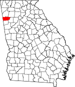
Polk County, Georgia Basics:


Polk County Georgia - Government Site

Population: 41,160
Area: 310 square miles
County seat: Cedartown
Area code(s) in use: 770
Time zone: EST
High school graduate or higher: 73.1%
Bachelor's degree or higher: 11.4%
Median household income: $38,861
Persons in poverty: 21.7%
Home ownership rate: 70.5%
Mean travel time to work: 26.8 minutes


Adjacent counties:
Bartow  Cherokee (AL)  Cleburne (AL)  Floyd  Haralson  Paulding  

Find in Georgia

Map of the Polk County area


Our detail map of Polk County shows the Polk County, Georgia boundary lines and other interesting items.

Places in Polk County, Georgia

  Airports     show all on map

Polk County Airport- Cornelius Moore Field

  Bridges     show all on map

Kings Bridge

  Buildings     show all on map

Aragon City Fire Department, Aragon Police Department, Cedartown City Hall, Cedartown Fire Department, Cedartown Police Department, Georgia State Patrol Troop A Post 29 Cedartown, Hawkes Library, Pineville (historical), Polk County Courthouse, Polk County Fire Department Aragon Station, Polk County Fire Department Blooming Grove Station, Polk County Fire Department Fish Creek Station, Polk County Fire Department Lake Creek Station, Polk County Fire Department Prior Station, Polk County Fire Department Youngs Station, Polk County Jail, Polk County Sheriff's Office, Polk County Volunteer Fire Department, Polk County Volunteer Fire Department Antioch Station, Polk County Volunteer Fire Department Esom Hill Station, Polk County Volunteer Fire Department Vinson Mountain Station, Rockmart Fire Department, Rockmart Police Department

  Cemeteries     show all on map

Edmondson Cemetery, Greenwood Cemetery, Hightower Cemetery, Hutching Cemetery, Jones Cemetery, Lime Branch Cemetery, Macedonia Cemetery, Maple Springs Cemetery, Northview Cemetery, Northview Cemetery, Oak Grove Baptist Church Cemetery, Pine Bower Baptist Church Cemetery, Polk Memorial Gardens, Red Hill Cemetery, Rockmart Memorial Gardens, Rose Hill Cemetery, Saint Johns Cemetery, Sanders Cemetery, Shiloh Baptist Church Cemetery, South Side Cemetery, Wimberly Hill Baptist Church Cemetery

  Churches     show all on map

Antioch Church, Aragon Baptist Church, Bellview African Methodist Episcopal Church, Bellview Baptist Church, Benedict Baptist Church, Berry Grove Church, Bethel Church, Bethlehem Church, Bethlehem Church, Blooming Grove Church, Calvary Assembly of God Church, Calvary Church, Cedar Springs Baptist Church (historical), Chapel of Saint Bernadette, Church of Christ, Church of God, Church of God (historical), Cleveland Chapel, Collard Valley Church, Congregational Holiness Church, Cornerstone Church, County Line Church, Crossroads Church, Daniel Merner Chapel, Eastview Baptist Church, Eastview Baptist Church, Eastview Church, Ebenezer African Methodist Episcopal Church, Euharlee Church, First Baptist Church of Cedartown, First Baptist Church of Rockmart, First United Methodist Church, Floyd Creek Church, Freedom Church, Friendly Baptist Church, Friendship Baptist Church, Friendship Church, Friendship Church, Gordon Hill Church, Harmony Church, Hills Creek Church, Hillside Mission, Holiness Church, Home View Church (historical), Jackson Chapel, Lake Creek Church, Lake Creek Church, Lake View Church, Lees Chapel, Lime Branch Church, Little Cedar Church, Live Oak Church, Marietta African Methodist Episcopal Church, Memorial Methodist Church, Morning View Church, Mount Home Church, Mount Sinai Church, New Bethel Church, New Euharlee Church, New Harmony Church, New Home Church, New Hope Church, New Prospect Church, Noah Chapel, Oak Grove Baptist Church, Oak Ridge Church, Open Door Church, Piedmont Avenue Baptist Church, Pine Bower Baptist Church, Pleasant Hill Church, Saint James Episcopal Church, Saint Lukes Church, Salem Church (historical), Sardis Church, Second Baptist Church of Cedartown, Second Baptist Church of Rockmart, Seney Church, Shady Grove Church, Shiloh Baptist Church, Southside Baptist Church, Springdale Church, Valley Grove Church, Valley View Church, Van Wert Church, Victory Church, Ware Grove Church, Wesley Chapel, West Aragon Church, Wimberly Hill Baptist Church, Youngs Grove Church

  Dams     show all on map

Big Cedar Creek Structure Number 13 Dam, Big Cedar Creek Structure Number 50 Dam, Casey Lake Dam, Cedar Rock Lake Dam, Crawford Lake Dam, Culp Lake Dam, Euharlee Creek Structure Number 51 Dam, Euharlee Creek Structure Number 76 Dam, Euharlee Creek Structure Number Four Dam, Euharlee Structure Number 49 Dam, Hightower Lake Dam Number One, Hobson Lake Dam, Hunts Lake Dam, King Lake Dam, Kirkpatrick Lake Dam, Lake Dorene Dam, Lower Coots Lake Dam, Lower Elder Lake Dam, Parham Springs Lake Dam, Pepper Lake Dam, Pine Hill Lake Dam, Springdale Lake Dam, Stringers Lake Dam, Upper Coots Lake Dam, Upper Elder Lake Dam, Vance Lake Dam, Williams Lake Dam, York Lake Dam

  Falls     show all on map

Hightower Falls

  Flats     show all on map

White Bottom

  Hospitals     show all on map

Murphy - Harpst Children's Centers, Polk General Hospital, Polk Medical Center

  Locales     show all on map

Aragon Station, Beatty Switch, Benedicts Mill, Camp Antioch, Camp Shepherd, Cedar Valley Country Club, Cherokee Country Club, Esom Station (historical), Fort Cedar Town, Hematite Crossing, Hickman Junction (historical), Hightower Mill (historical), Oremont Station, Simpson Mill (historical)

  Military     show all on map

Fort Cedartown (historical)

  Mines     show all on map

Deaton Mine, Rockmart Quarry, Woodward Mine

  Parks     show all on map

Optimist Field, Peek Forest Park

  Populated Places     show all on map

Akes, Antioch, Aragon, Benedict, Brewers (historical), Briscoe (historical), Caseyville, Cedartown, Davitte (historical), Don (historical), Esom Hill, Etna, Fearing (historical), Fish, Fish Creek, Friendship, Fullwood Springs, Grady (historical), Greenway (historical), Hamlet (historical), Iron Stab, Lake Creek, Portland, Posco (historical), Prior, Ravenel (historical), Red Ore (historical), Rockmart, Seney, Treat (historical), Van Wert, Walthrall (historical), Winkles (historical), Youngs

  Post Offices     show all on map

Aragon Post Office, Berry Post Office (historical), Cedartown Post Office, Esom Hill Post Office, Etna Post Office (historical), Fish Post Office (historical), Hamlet Post Office (historical), Lakecreek Post Office (historical), Lime Branch Post Office (historical), Oremont Post Office (historical), Portland Post Office (historical), Posco Post Office (historical), Priors Post Office (historical), Seney Post Office (historical), Walthrall Post Office (historical), Youngs Post Office (historical)

  Reservoirs     show all on map

Becks Lake, Benedicts Pond, Bentley Lake, Brocks Lake, Camp Shepherd Lake, Casey Lake, Cedar Rock Lake, Coots Lake, Crawford Lake, Culp Lake, Davis Lake, Dorene Lake, Elder Lakes, Everett Lake, Forsyth Lake, Hightower Lake, Hobson Lake, Hunts Lake, Johnson Lake, King Lake, Kirkpatrick Lake, Lake Dorene, Last Lake, Lindsey Lake, Lower Coots Lake, Lower Elder Lake, Lower Hightower Falls Lake, Parham Springs Lake, Parham Springs Lake, Pepper Lake, Pettit Lake, Pine Hill Lake, Shiloh Lake, Smith Lake, Springdale Lake, Stringers Lake, Upper Coots Lake, Upper Elder Lake, Vance Lake, Williams Lake, York Lake

  Schools     show all on map

Antioch School (historical), Benedict School, Biggers School (historical), Brewster School, Calvary Christian School, Cedar Hill High School (historical), Cedar Hill School, Cedartown High School, Cedartown Middle School, Cherokee Elementary School, College Street School, Eastside Elementary School, Eastview Public School (historical), Elm Street School, Ethel Harpst School for Dependent Children (historical), Euharlee School, Fite School, Fite School (historical), Goodyear Elementary School, Harpst Academy, Jones School (historical), Lake Creek School, Lyle School, Northside Elementary School, Old Brewster School (historical), Purks Middle School, Rockmart High School, Rockmart Middle School, Vineyard Harvester Christian Academy, West End Grammar School (historical), Westside Elementary School

  Springs     show all on map

Browder Spring, Cedartown Spring, Davette Spring, Deaton Spring, Everett Springs, Fish Spring, Jones Spring, Locke Spring, Parham Springs, Philpott Spring, West Spring, Youngs Spring

  Streams     show all on map

Baker Pole Branch, Bordens Creek, Dry Creek, Esom Slough, Fish Creek, Forked Branch, Hematite Branch, Hills Creek, Hutchings Creek, Lime Branch, Little Cedar Creek, Mackey Branch, McCurry Creek, Mineral Spring Branch, Parham Springs Creek, Popham Branch, Pumpkin Pile Creek, Riles Creek, Sat Brown Branch, Simpson Creek, Tan Yard Branch, Thompson Creek, Winkley Branch

  Summits     show all on map

Brewster Mountain, Casey Mountain, Cobb Mountain, Dugdown Mountain, Etna Mountain, Everett Mountain, Hightower Mountain, Loveless Mountain, Paris Mountain, Potato Hill, Shorty Mountain, Signal Mountain, Treat Mountain, Vinson Mountain

  Towers     show all on map

WGAA-AM (Cedartown), WZOT-AM (Rockmart)

  Valleys     show all on map

Devils Darning Needle Hollow, Etna Valley, Happy Hollow, Morgan Valley,

Polk County, Georgia Population By Race (2012 estimate)

RacePopulation
WhitePolk County White population 34,53334,533  
BlackPolk County Black population 5,3105,309
MixedPolk County Mixed population 617617
American IndianPolk County American Indian population 329329
Hawaiian & Pacific IslanderPolk County Hawaiian & Pacific Islander population 8282

Additional population tables :
State population table
Georgia population by county